1. Marine Science and Technology College, Zhejiang Ocean University, Zhoushan 316022, China 2. Zhejiang Province Ecological Environment Monitoring Centre (Zhejiang Key Laboratory of Ecological and Environmental Monitoring, Forewarning and Quality Control), Hangzhou 310012, China 3. State Key Laboratory of Satellite Ocean Environment Dynamics (Second Institute of Oceanography, MNR), Hangzhou 310012, China 4. State Information Center, Beijing 100045, China 5. Xiamen Raw Water Investment Co., Ltd., Xiamen 361000, China 6. School of Economics and Management, Zhejiang Ocean University, Zhoushan 316022, China
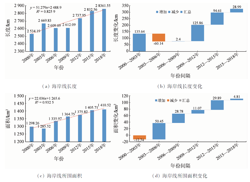
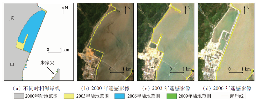
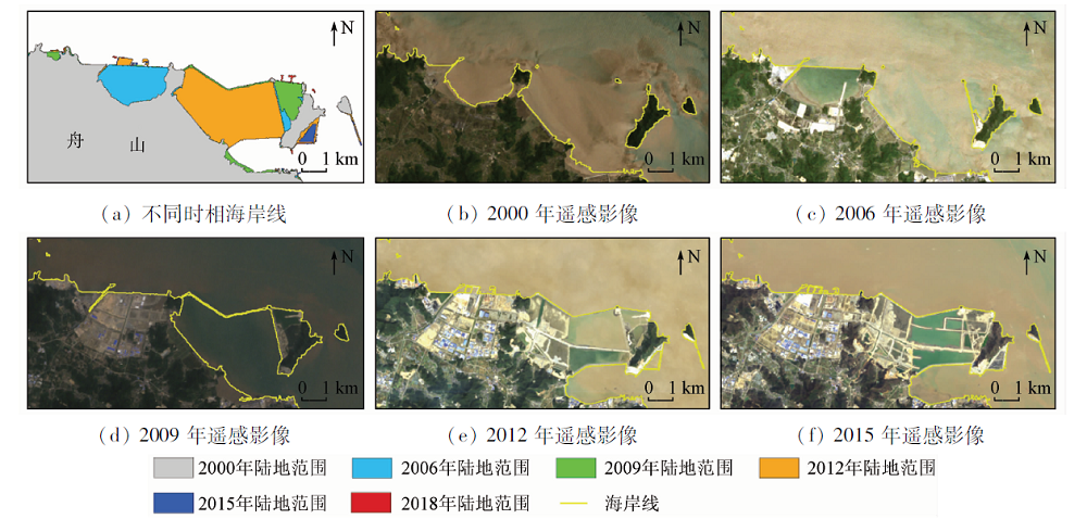
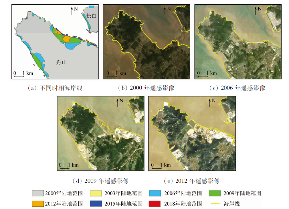
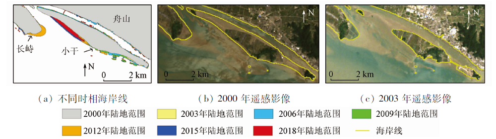
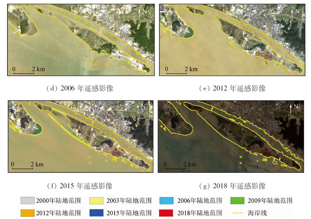
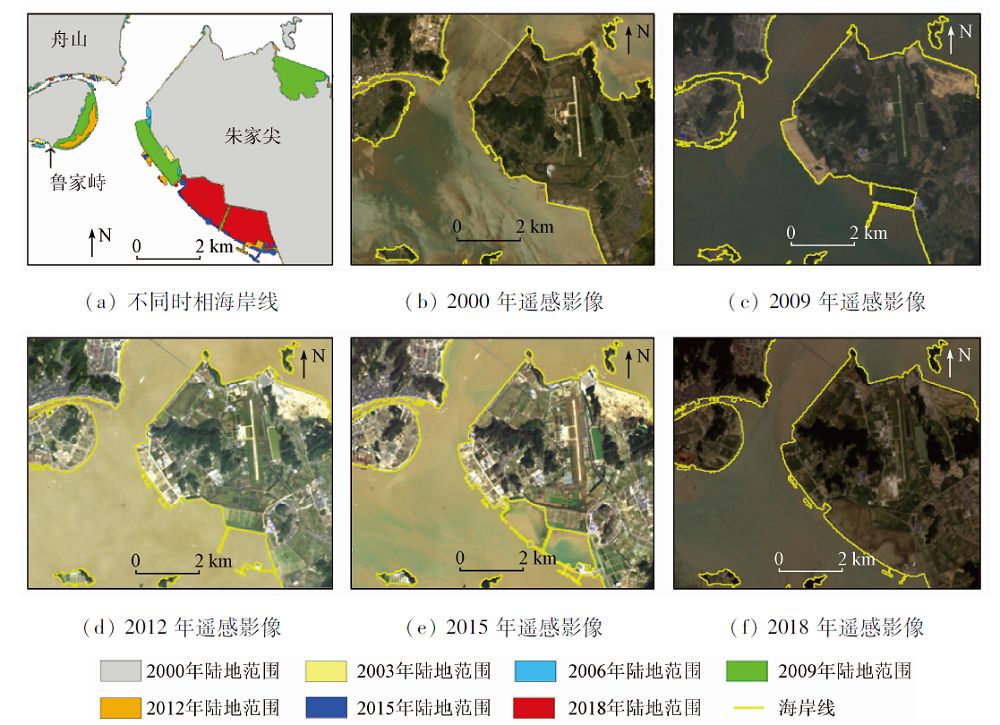
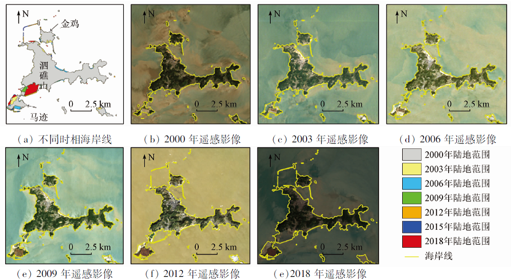
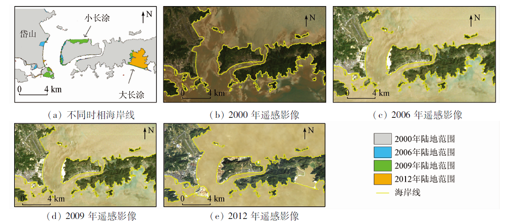
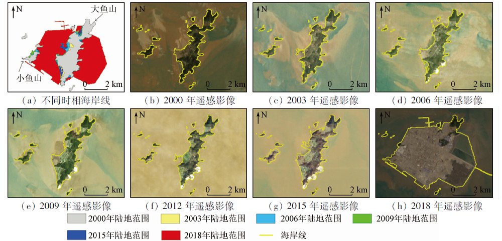
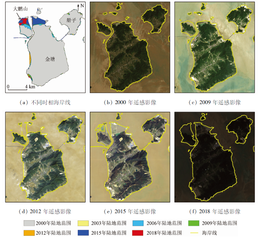
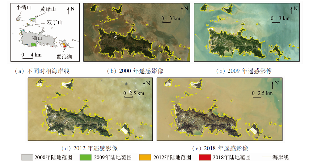
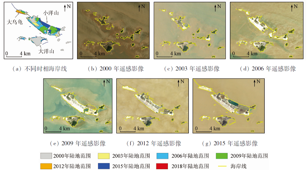
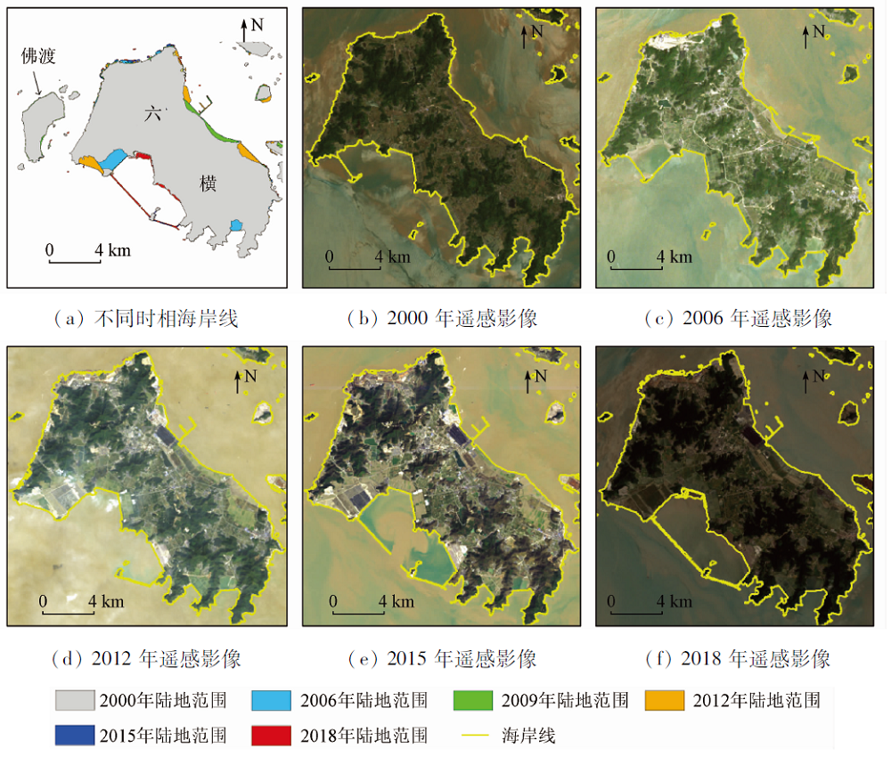
With a special geographical location and abundant marine resources, Zhoushan is the first prefecture-level city composed of islands in China. Therefore, the acquisition of dynamic information on the coastline is of great significance to this area. However, the large amount of suspended sediments, the tortuous coastline, the numerous tidal flats and some other factors have brought a lot of challenges to coastline extraction and the analysis of the spatial-temporal dynamics in Zhoushan Islands. In order to solve this problem, the authors have developed a method for extracting coastline remote sensing information based on the tasseled cap transformation and used long time series satellite remote sensing data to carry out the analysis of the temporal and spatial evolution of the coastline. The experimental results show that the proposed method can effectively remove the influence of suspended sediments, winding coastline and shoals on the extraction of coastline information, and make its position accurate. From 2000 to 2018, the total length of the coastline of Zhoushan Islands increased by about 327.36 km, the average growth length was 18.19 km, the average growth rate was 0.72%, the total area of Zhoushan Islands increased by about 112.26 km2, the average growth area was 6.24 km2, and the average growth rate was 0.49%. The constructions of reclamation and marine projects seem to have been the main reasons for Zhoushan’s coastline changes. This study is of great significance for improving the accuracy of coastline remote sensing information extraction as well as coastal development and protection in complex marine environments.
Wu Y Q, Liu Z L. Research progress on methods of automatic coastline extraction based on remote sensing images[J]. Journal of Remote Sensing, 2019, 23(4):582-602.
[2]
Ai B, Zhang R, Zhang H, et al. Dynamic process and artificial mechanism of coastline change in the Pearl River Estuary[J]. Regional Studies in Marine Science, 2019, 30:100715.
doi: 10.1016/j.rsma.2019.100715
[3]
Cao W, Zhou Y, Li R, et al. Mapping changes in coastlines and tidal flats in developing islands using the full time series of Landsat images[J]. Remote Sensing of Environment, 2020, 239:111665.
doi: 10.1016/j.rse.2020.111665
[4]
Kelly J T, Gontz A M. Using GPS-surveyed intertidal zones to determine the validity of shorelines automatically mapped by Landsat water indices[J]. International Journal of Applied Earth Observation and Geoinformation, 2018, 65:92-104.
doi: 10.1016/j.jag.2017.10.007
Liang L, Liu Q S, Liu G H, et al. Review of coastline extraction methods based on remote sensing images[J]. Journal of Geo-information Science, 2018, 20(12):1745-1755.
Wang Z H, Yang X M, Su F Z, et al. Remote sensing application in China’s coastal zones and islands:Recent progress and some suggestions[J]. Strategic Study of CAE, 2019, 21(6):59-63.
[7]
Almonacid-Caballer J, Sánchez-García E, Pardo-Pascual J E, et al. Evaluation of annual mean shoreline position deduced from Landsat imagery as a mid-term coastal evolution indicator[J]. Marine Geology, 2016, 372:79-88.
doi: 10.1016/j.margeo.2015.12.015
Li J L, Wang L J. Spatial and temporal evolutions of the major bays in the East China Sea under the influence of reclamataion[J]. Acta Geographica Sinica, 2020, 75(1):126-142.
Sui Y, Zhang L, Mu X D, et al. Coastline change detection and analysis with remote sensing in Hainan Island[J]. Journal of Marine Sciences, 2018, 36(3):36-43.
Wu T, Hou X Y. Review of research on coastline changes[J]. Acta Ecologica Sinica, 2016, 36(4):1170-1182.
[11]
Sun W, Peng J, Yang G, et al. Correntropy-based sparse spectral clustering for hyperspectral band selection[J]. IEEE Geoscience and Remote Sensing Letters, 2020, 17(3):484-488.
doi: 10.1109/LGRS.8859
[12]
Sun W, Yang G, Peng J, et al. Lateral-slice sparse tensor robust principal component analysis for hyperspectral image classification[J]. IEEE Geoscience and Remote Sensing Letters, 2020, 17(1):107-111.
doi: 10.1109/LGRS.8859
Sun W W, Yang G, Chen C, et al. Development status and literature analysis of China’s earth observation remote sensing satellites[J]. Journal of Remote Sensing, 2019, 24(5):479-510.
Zhang B. Remotely sensed big data era and intelligent information extraction[J]. Geomatics and Information Science of Wuhan University, 2018, 43(12):1861-1871.
[15]
Dai C, Howat I M, Larour E, et al. Coastline extraction from repeat high resolution satellite imagery[J]. Remote Sensing of Environment, 2019, 229:260-270.
doi: 10.1016/j.rse.2019.04.010
[16]
Sagar S, Roberts D, Bala B, et al. Extracting the intertidal extent and topography of the Australian coastline from a 28 year time series of Landsat observations[J]. Remote Sensing of Environment, 2017, 195:153-169.
doi: 10.1016/j.rse.2017.04.009
[17]
Ghosh M K, Kumar L, Roy C. Monitoring the coastline change of Hatiya island in Bangladesh using remote sensing techniques[J]. ISPRS Journal of Photogrammetry and Remote Sensing, 2015, 101:137-144.
doi: 10.1016/j.isprsjprs.2014.12.009
[18]
Li W, Gong P. Continuous monitoring of coastline dynamics in Western Florida with a 30-year time series of Landsat imagery[J]. Remote Sensing of Environment, 2016, 179:196-209.
doi: 10.1016/j.rse.2016.03.031
[19]
Liu C, Wu X, Cao X, et al. Analysis of coastline changes and the socio-economic driving mechanisms in Shenzhen,China[J]. Marine Geodesy, 2017, 40(6):378-403.
doi: 10.1080/01490419.2017.1319447
[20]
Wu T, Hou X, Xu X. Spatio-temporal characteristics of the mainland coastline utilization degree over the last 70 years in China[J]. Ocean & Coastal Management, 2014, 98:150-157.
Zhang Y Z, Zhang Q L, Hu Y F. Remote sensing monitoring and dynamic analysis of the Pearl River Estuary coastline during 2010—2017[J]. Marine Science Bulletin, 2019, 38(2):217-224.
[22]
Hsiao Y S, Hwang C, Cheng L C, et al. High-resolution depth and coastline over major atolls of South China Sea from satellite altimetry and imagery[J]. Remote Sensing of Environment, 2016, 176:69-83.
doi: 10.1016/j.rse.2016.01.016
[23]
Mulcahy N, Kennedy D M, Blanchon P. Hurricane-induced shoreline change and post-storm recovery:Northeastern Yucatan Peninsula,Mexico[J]. Journal of Coastal Research, 2016, 75(s1):1192-1196.
doi: 10.2112/SI75-239.1
[24]
Hou X, Wu T, Hou W, et al. Characteristics of coastline changes in Mainland China since the early 1940s[J]. Science China Earth Sciences, 2016, 59,1791-1802.
doi: 10.1007/s11430-016-5317-5
[25]
Maglione P, Parente C, Vallario A. Coastline extraction using high resolution WorldView-2 satellite imagery[J]. European Journal of Remote Sensing, 2014, 47(1),685-699.
doi: 10.5721/EuJRS20144739
[26]
Pillet V, Duvat V K E, Krien Y, et al. Assessing the impacts of shoreline hardening on beach response to hurricanes:Saint-Barthélemy,Lesser Antilles[J]. Ocean & Coastal Management, 2019, 174:71-91.
[27]
Quang T N, Cong T H, Quang D L, et al. Historical monitoring of shoreline changes in the Cua Dai Estuary,Central Vietnam using multi-temporal remote sensing data[J]. Geosciences, 2017, 7(3):7030072.
[28]
Sun Y, Gao C, Li J, et al. Evaluating urban heat island intensity and its associated determinants of towns and cities continuum in the Yangtze River Delta urban agglomerations[J]. Sustainable Cities and Society, 2019, 50:101659.
doi: 10.1016/j.scs.2019.101659
[29]
Bera R, Maiti R. Quantitative analysis of erosion and accretion (1975—2017) using DSAS:A study on Indian Sundarbans[J]. Regional Studies in Marine Science, 2019, 28:100583.
doi: 10.1016/j.rsma.2019.100583
[30]
Bronstein M M, Bruna J, Lecun Y, et al. Geometric deep learning:Going beyond euclidean data[J]. IEEE Singnal Processing Magazine, 2017, 34(4):18-42.
[31]
Li J, Ye M, Pu R, et al. Spatiotemporal change patterns of coastlines in Zhejiang Province,China,over the last twenty-five years[J]. Sustainability, 2018, 10(2):477.
doi: 10.3390/su10020477
[32]
Liu C, Xiao Y, Yang J. A coastline detection method in polarimetric SAR images mixing the region-based and edge-based active contour models[J]. IEEE Transactions on Geoscience and Remote Sensing, 2017, 55(7):3735-3747.
doi: 10.1109/TGRS.2017.2679112
Zhu C M, Zhang X, Luo J C, et al. Automatic extraction of coastline by remote sensing technology based on SVM and auto-selection of training samples[J]. Remote Sensing for Land and Resources, 2013, 25(2):69-74.doi; 10.6046/gtzyyg.2013.02.13.
doi: 10.6046/gtzyyg.2013.02.13
Hu Y B, Ren G B, Ma Y, et al. Remote sensing monitoring and evolution analysis of the coastline in the Lianyungang City based on multi-temporal GF-1 and Landsat images during 44 years[J]. Ocean Technology, 2019, 38(6):9-16.
[35]
Tsokos A, Kotsi E, Petrakis S, et al. Combining series of multi-source high spatial resolution remote sensing datasets for the detection of shoreline displacement rates and the effectiveness of coastal zone protection measures[J]. Journal of Coastal Conservation, 2018, 22:431-441.
doi: 10.1007/s11852-018-0591-3
[36]
Wu W, Yang Z, Tian B, et al. Impacts of coastal reclamation on wetlands:Loss,resilience,and sustainable management[J]. Estuarine,Coastal and Shelf Science, 2018, 210:153-161.
doi: 10.1016/j.ecss.2018.06.013
[37]
Xu N, Gong P. Significant coastline changes in China during 1991—2015 tracked by Landsat data[J]. Science Bulletin, 2018, 63(14):883-886.
doi: 10.1016/j.scib.2018.05.032
[38]
Liu Y, Li J, Yuan Q, et al. Comparative research on the impact of human activities on changes in coastline and landscape in bay areas:A case study with Xiangshangang bay,China and Tampa bay,USA[J]. Acta Geographica Sinica, 2016, 71(1):86-103.
[39]
Naser H A. The role of environmental impact assessment in protecting coastal and marine environments in rapidly developing islands:The case of Bahrain,Arabian Gulf[J]. Ocean & Coastal Management, 2015, 104:159-169.
Chen C, He X Y, Fu J Q, et al. A method of flood submerging area extracting for farmland based on tasseled cap transformation from remote sensing images[J]. Geomatics and Information Science of Wuhan University, 2019, 44(10):1560-1566.
Sha H J, Zhang D, Cui D D, et al. Remote sensing prediction method of coastline based on self-adaptive profile morphology[J]. Haiyang Xuebao, 2019, 41(9):170-180.
Lu X, Chen C. Research on spatial-temporal pattern of land use in Zhoushan City by using remote sensing images[J]. Journal of Zhejiang University of Science and Technology, 2018, 30(5):404-411.
[43]
Qiao G, Mi H, Wang W, et al. 55-year (1960—2015) spatiotemporal shoreline change analysis using historical DISP and Landsat time series data in Shanghai[J]. International Journal of Applied Earth Observation and Geoinformation, 2018, 68:238-251.
doi: 10.1016/j.jag.2018.02.009
[44]
Zhang B, Chen Z, Peng D, et al. Remote sensed big data:Evolution in model development for information extraction[J]. Proceedings of the IEEE, 2019, 107(12):2294-2301.
doi: 10.1109/JPROC.2019.2948454
[45]
Tian B, Wu W, Yang Z, et al. Drivers,trends,and potential impacts of long-term coastal reclamation in China from 1985 to 2010[J]. Estuarine,Coastal and Shelf Science, 2016, 170:83-90.
doi: 10.1016/j.ecss.2016.01.006
[46]
Tran T V, Tien T, Xuan A, Phan N H, et al. Application of remote sensing and GIS for detection of long-term mangrove shoreline changes in Mui Ca Mau,Vietnam[J]. Biogeosciences, 2014, 11:3781-3795.
doi: 10.5194/bg-11-3781-2014
Li J L, Tian P, Shao S Y, et al. The changes of continental coastline and its development and utilization intensity in the East China Sea[J]. Journal of Natural Resources, 2019, 34(9):1886-1901.
[48]
Chen C, Bu J, Zhang Y, et al. The application of the tasseled cap transformation and feature knowledge for the extraction of coastline information from remote sensing images[J]. Advances in Space Research, 2019, 64(9):1780-1791.
doi: 10.1016/j.asr.2019.07.032
[49]
Chen C, Fu J, Zhang S, et al. Coastline information extraction based on the tasseled cap transformation of Landsat-8 OLI images[J]. Estuarine,Coastal and Shelf Science, 2019, 217:281-291.
doi: 10.1016/j.ecss.2018.10.021
 2021, Vol. 33
  ), 陈慧欣1, 陈东4, 张自力2(