Application of random forest and Sentinel-1/2 in the information extraction of impervious layers in Dongying City
LIU Chunting1(), FENG Quanlong2, JIN Dingjian3, SHI Tongguang1, LIU Jiantao1(), ZHU Mingshui1
1. School of Surveying and Geo-Informatics, Shandong Jianzhu University, Jinan 250101, China 2. College of Land Science and Technology, China Agriculture University, Beijing 100083, China 3. China Aero Geophysical Survey & Remote Sensing Center for Natural Resources, Beijing 100083, China
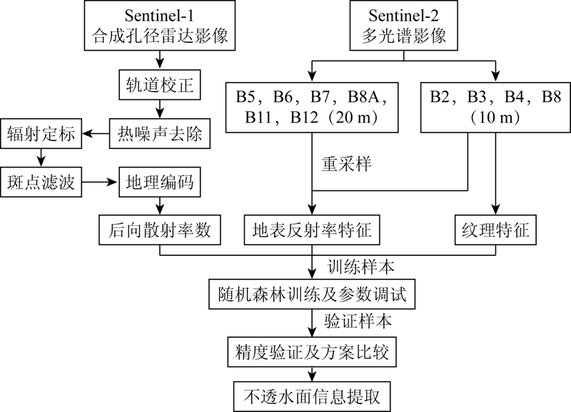
An impervious layer is an important indicator of human activities. Timely and accurate information of impervious layers is of great significance for the protection of the ecological environment. Taking the Yellow River Delta (Dongying City) as the study area, this study explores a novel extraction method of impervious layers by combining the random forest classification with Sentinel-1/2 data. According to comparative experiments, the confusion between dark and light impervious layers and bare soil can be reduced through the combination of the random forest algorithm with surface reflectance characteristics, texture characteristics, and backscatter coefficient, thus effectively improving the estimation accuracy of impervious layers (overall accuracy: 93.37%, Kappa coefficient: 0.925 8). The results of this study reveal that the random forest algorithm combined with Sentinel-1/2 data is a promising approach in the information extraction of impervious layers, which will provide a reference for the remote sensing monitoring of the Yellow River Delta through the integration of multi-source data.
刘春亭, 冯权泷, 金鼎坚, 史同广, 刘建涛, 朱明水. 随机森林协同Sentinel-1/2的东营市不透水层信息提取[J]. 自然资源遥感, 2021, 33(3): 253-261.
LIU Chunting, FENG Quanlong, JIN Dingjian, SHI Tongguang, LIU Jiantao, ZHU Mingshui. Application of random forest and Sentinel-1/2 in the information extraction of impervious layers in Dongying City. Remote Sensing for Natural Resources, 2021, 33(3): 253-261.
Arnold L C, Gibbons C J. Impervious surface coverage:The emergence of a key environmental indicator[J]. Journal of The American Planning Association, 1996, 62(2):243-258.
doi: 10.1080/01944369608975688
[2]
Leinenkugel P, Esch T, Kuenzer C. Settlement detection and impervious surface estimation in the Mekong Delta using optical and SAR remote sensing data[J]. Remote Sensing of Environment, 2011, 115(12):3007-3019.
doi: 10.1016/j.rse.2011.06.004
[3]
Weng Q H, Hu X F. Medium spatial resolution satellite imagery for estimating and mapping urban impervious surfaces using LSMA and ANN[J]. IEEE Transactions on Geoscience and Remote Sensing, 2008, 46(8):2397-2406.
doi: 10.1109/TGRS.2008.917601
[4]
Liu Z H, Wang Y L, Li Z G, et al. Impervious surface impact on water quality in the process of rapid urbanization in Shenzhen,China[J]. Environmental Earth Sciences, 2013, 68(8):2365-2373.
doi: 10.1007/s12665-012-1918-2
[5]
Ma Q, He C Y, Wu J G, et al. Quantifying spatiotemporal patterns of urban impervious surfaces in China:An improved assessment using nighttime light data[J]. Landscape and Urban Planning, 2014, 130:36-49.
doi: 10.1016/j.landurbplan.2014.06.009
[6]
Ridd M K. Exploring a V-I-S (vegetation-impervious surface-soil) model for urban ecosystem analysis through remote sensing:Comparative anatomy for citiest[J]. International Journal of Remote Sensing, 1995, 16(12):2165-2185.
doi: 10.1080/01431169508954549
[7]
Wu C, Murray A T. Estimating impervious surface distribution by spectral mixture analysis[J]. Remote Sensing of Environment, 2003, 84(4):493-505.
doi: 10.1016/S0034-4257(02)00136-0
Zhou C L, Xu H Q. A spectral mixture analysis and mapping of impervious surfaces in built-up land of Fuzhou City[J]. Journal of Image Graphics, 2007(5):875-881.
[9]
Carlson T N, Arthur S T. The impact of land use-land cover changes due to urbanization on surface microclimate and hydrology:A satellite perspective[J]. Global & Planetary Change, 2000, 25(1):49-65.
Xu H Q. A new remote sensing index for fastly extracting impervious surface information[J]. Geomatics and Information Science of Wuhan University, 2008(11):1150-1153.
[11]
Liu C, Shao Z, Chen M, et al. MNDISI:A multi-source composition index for impervious surface area estimation at the individual city scale[J]. Remote Sensing Letters, 2013, 4(8):803-812.
doi: 10.1080/2150704X.2013.798710
Liao M S, Jiang L M, Lin H, et al. Estimating urban impervious surface percent using boosting as a refinement of CART analysis[J]. Geomatics and Information Science of Wuhan University, 2007(12):1099-1102.
Li X N, Zhang Y J, She Y J, et al. Estimation of impervious surface percentage of river network regions using an ensemble leaning of CART analysis[J]. Remote Sensing for Land and Resources, 2013, 25(4):174-179.doi: 10.6046/gtzyyg.2013.04.28.
doi: 10.6046/gtzyyg.2013.04.28
[14]
Sung C Y, Yi Y J, Li M H. Impervious surface regulation and urban sprawl as its unintended consequence[J]. Land Use Policy, 2013, 32:317-323.
doi: 10.1016/j.landusepol.2012.10.001
Cheng X, Shen Z F, Luo J C, et al. Estimation impervious surface based on comparison of spectral mixture analysis and support vector machine methods[J]. Remote Sensing, 2011, 15(6):1228-1241.
[16]
Sun Z C, Guo H D, Li X W, et al. Estimating urban impervious surfaces from Landsat 5 TM imagery using multilayer perceptron neural network and support vector machine[J]. Journal of Applied Remote Sensing, 2011, 5(1):053501.
doi: 10.1117/1.3539767
Liu Y, Meng Q Y, Wang Y J, et al. A method for estimating impervious surface percentage based on feature optimization and SVM[J]. Geography and Geo-Information Science, 2018, 34(1):24-31.
Luo C F. Estimating urban impervious surface percentage with BP neural network based on genetic algorithm[J]. Science of Surveying and Mapping, 2011, 36(1):48-50.
[19]
Hu X F, Weng Q H. Estimating impervious surfaces from medium spatial resolution imagery using the self-organizing map and multi-layer perceptron neural networks[J]. Remote Sensing of Environment, 2009, 113(10):2089-2102.
doi: 10.1016/j.rse.2009.05.014
[20]
Zhang Y Z, Zhang H S, Lin H, et al. Improving the impervious surface estimation with combined use of optical and SAR remote sensing images[J]. Remote Sensing of Environment, 2014, 141:155-167.
doi: 10.1016/j.rse.2013.10.028
[21]
Shao Z F, Fu H Y, Fu P, et al. Mapping urban impervious surface by fusing optical and SAR data at the decision level[J]. Remote Sensing, 2016, 8(11),945-965.
doi: 10.3390/rs8110945
[22]
Guo H D, Yang H N, Sun Z C, et al. Synergistic use of optical and PolSAR imagery for urban impervious surface estimation[J]. Photogrammetric Engineering and Remote Sensing, 2014, 80(1):91-102.
doi: 10.14358/PERS.80.1.91
[23]
Deng C B, Wu C S. Examining the impacts of urban biophysical compositions on surface urban heat island:A spectral unmixing and thermal mixing approach[J]. Remote Sensing of Environment, 2013, 131:262-274.
doi: 10.1016/j.rse.2012.12.020
[24]
Weng Q H. Remote sensing of impervious surfaces in the urban areas:Requirements,methods,and trends[J]. Remote Sensing of Environment, 2012, 117:34-49.
doi: 10.1016/j.rse.2011.02.030
[25]
Zhang Y Z, Zhang H S, Lin H. Improving the impervious surface estimation with combined use of optical and SAR remote sensing images[J]. Remote Sensing of Environment, 2014, 141:155-167.
doi: 10.1016/j.rse.2013.10.028
Tang T Y, Fu B L, He S Y, et al. Identification of typical land features in the Lijiang River Basin with fusion optics and Radar[J]. Remote Sensing Technology and Application, 2020, 35(2):448-457.
Zhang H S, Lin Y Y, Wang T, et al. Fusing optical and SAR remote sensing data for urban impervious surface estimation[J]. Geography and Geo-Information Science, 2018, 34(3):39-46.
[28]
Masound M, Bahram S, Fariba M, et al. Random forest wetland classification using ALOS-2L-band,RADARSAT-2C-band and TerraSAR-X imagery[J]. ISPRS Journal of Photogrammetry and Remote Sensing, 2017, 130:13-31.
doi: 10.1016/j.isprsjprs.2017.05.010
[29]
Zhang H S, Zhang Y Z, Lin H. A comparison study of impervious surfaces estimation using optical and SAR remote sensing images[J]. International Journal of Applied Earth Observation and Geoinformation, 2012, 18:148-156.
doi: 10.1016/j.jag.2011.12.015
[30]
Zhang H S, Li J, Wang T, et al. A manifold learning approach to urban land cover classification with optical and Radar data[J]. Landscape and Urban Planning, 2018, 172:11-24.
doi: 10.1016/j.landurbplan.2017.12.009
[31]
Zhang Y Z, Zhang H S, Hui L, et al. Improving the impervious surface estimation with combined use of optical and SAR remote sensing images[J]. Remote Sensing of Environment, 2014, 141:155-167.
doi: 10.1016/j.rse.2013.10.028
[32]
Zhang H S, Lin H, Li Y, et al. Mapping urban impervious surface with dual-polarimetric SAR data:An improved method[J]. Landscape and Urban Planning, 2016, 151:55-63.
doi: 10.1016/j.landurbplan.2016.03.009
Chen K, Xiao N W, Wang B X, et al. The effects of petroleum on water quality bio-assessment and benthic macro-invertbrate communities in the Yellow River Delta wetland,Dongying[J]. Acta Ecologica Sinica, 2012, 32(6):1970-1978.
doi: 10.5846/stxb
Ding T T, Zhou T G, Zhu X B, et al. On dynamic changes of wetland in Yellow River Delta with remote sensing images:A case study of Dongying City[J]. Southwest Normal University(Natural Science Edition), 2016, 41(4):52-57.
Qin T T, Qi W, Xu B Q, et al. Impacts of road on land use based on RV index in Yellow River Delta:A case in Dongying City[J]. Heibei Agricultural Sciences, 2011, 15(11):67-72.
[36]
刘翠翠. 黄河三角洲湿地生态修复工程效果研究[D]. 济南:山东师范大学, 2013.
Liu C C. The study of the wetland restoration engineering effect in Yellow River Delta[D]. Jinan:Shandong Normal University, 2013.
Hou X H, Li X H. Characteristics of land cover change in the Yellow River estuary nature reserve from 1992 to 2010[J]. Subtropical Plant Science, 2015, 44(4):309-314.
[38]
Lee J S. Digital image smoothing and the sigma filter[J]. Computer Vision Graphics and Image Processing, 1983, 24:255-269.
doi: 10.1016/0734-189X(83)90047-6
[39]
Lopes A, Touzi R, Nezry E. Adaptive speckle filters and scene heterogeneity[J]. IEEE Transactions on Geoscience and Remote Sensing, 1990, 28:992-1000.
doi: 10.1109/36.62623
[40]
Xie H, Pierce L E, Ulaby F T. SAR speckle reduction using wavelet denoising and Markov random field modeling[J]. IEEE Transactions on Geoscience and Remote Sensing, 2002, 40:2196-2212.
doi: 10.1109/TGRS.2002.802473
[41]
Feng Q L, Liu J T, Gong J H. UAV remote sensing for urban vegetation mapping using random forest and texture analysis[J]. Remote sensing, 2015, 7(1):1074-1094.
doi: 10.3390/rs70101074
[42]
Dell’Acqua F, Gamba P. Texture-based characterization of urban environments on satellite SAR images[J]. IEEE Transactions on Geoscience and Remote Sensing, 2003, 41:153-159.
doi: 10.1109/TGRS.2002.807754
[43]
Stasolla M, Gamba P. Spatial indexes for the extraction of formal and informal human settlements from high-resolution SAR images[J]. IEEE Journal of Selected Topics in Applied Earth Observations and Remote Sensing, 2008, 1(2):98-106.
doi: 10.1109/JSTARS.4609443
[44]
Feng Q L, Liu J T, Gong J H. Urban flood mapping based on unmanned aerial vehicle remote sensing and random forest classifier:A case of Yuyao,China[J]. Water, 2015, 7(4):1437-1455.
doi: 10.3390/w7041437
[45]
Puissant A, Hirsch J, Weber C. The utility of texture analysis to improve per-pixel classification for high to very high spatial resolution imagery[J]. International Journal of Remote Sensing, 2005, 26:733-745.
doi: 10.1080/01431160512331316838
[46]
Breiman L. Random forests[J]. Machine Learning, 2001, 45(1):5-32.
doi: 10.1023/A:1010933404324
[47]
蒲东川. 多源卫星遥感数据驱动的城市不透水面提取[D]. 长春:吉林大学, 2020.
Pu D C. Urban impervious surface extraction driven by multi-source satellite remote sensing data[D]. Changchun:Jilin University, 2020.
Cai B W, Wang S G, Wang L, et al. Extraction of urban impervious surface from high-resolution remote sensing imagery based on deep learning[J]. Geo-Information Science, 2019, 21(9):1420-1429.
Shao Z F, Zhang Y, Zhou W Q, et al. Extraction of urban impervious surface based on high resolution remote sensing image[J]. Geospatial Information, 2016, 14(7):1-6.
Zhu D H, Liu Y M, Feng Q L, et al. Spatial-temporal dynamic changes of agricultural greenhouses in Shandong Province in recent 30 years based on Google Earth Engine[J]. Transactions of the Chinese Society for Agricultural Machinery, 2020, 51(1):168-175.
[51]
Rodriguez-Galiano V F, Ghimire B, Rogan J, An assessment of the effectiveness of a random forest classifier for land-cover classification[J]. ISPRS Journal of Photogrammetry and Remote Sensing, 2012, 67:93-104.
doi: 10.1016/j.isprsjprs.2011.11.002
 2021, Vol. 33
  ), 冯权泷2, 金鼎坚3, 史同广1, 刘建涛1(