Change detection of remote sensing images based on the fusion of co-saliency difference images
WANG Yiuzhu1(), HUANG Liang1,2(), CHEN Pengdi1, LI Wenguo1, YU Xiaona3
1. Faculty of Land Resource Engineering, Kunming University of Science and Technology, Kunming 650093, China 2. Surveying and Mapping Geo-Informatics Technology Research Center on Plateau Mountains of Yunnan Higher Education, Kunming 650093, China 3. Kunming Vocational and Technical College of Industry, Kunming 650302, China
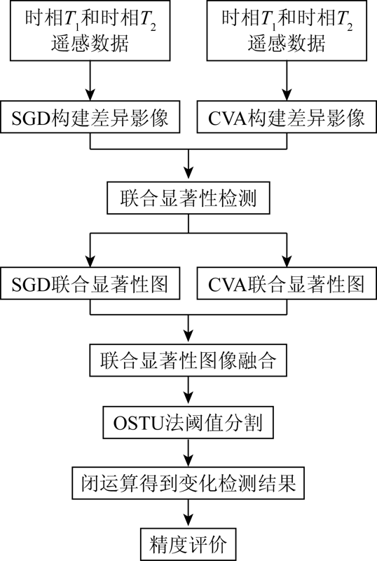
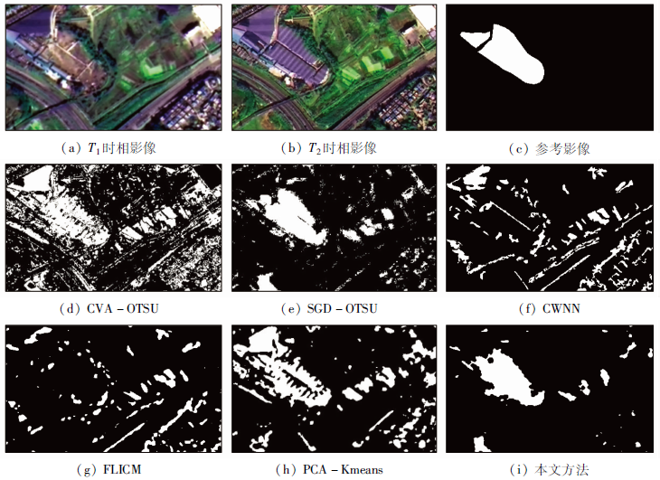
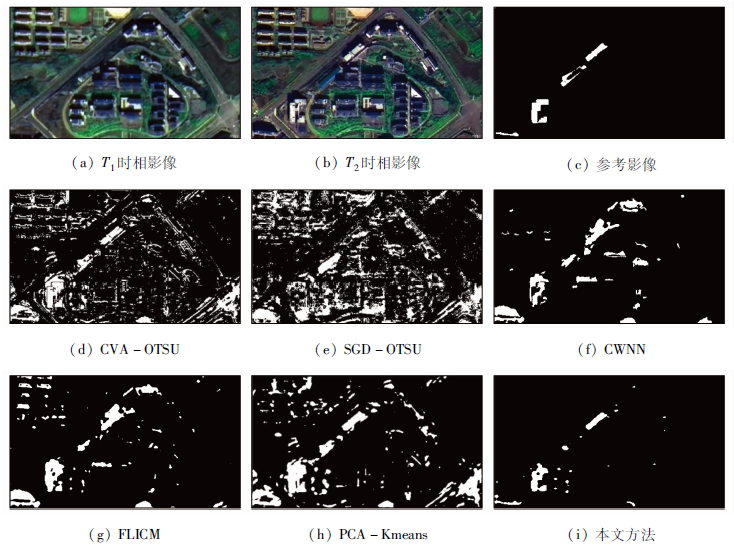
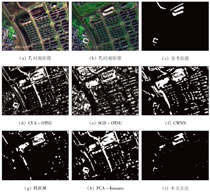
Owing to the complex surface features in the high spatial resolution (HR) remote sensing images, traditional change detection methods suffer the shortcoming of a high omission rate. Given this, this paper proposed a change detection method based on multi-temporal remote sensing images based on the fusion of co-saliency difference images. In this study, three groups of dual-temporal HR remote sensing images were selected to carry out the experiment according to the following steps. First, develop difference images based on the dual-temporal HR remote sensing images using the methods of change vector analysis (CVA) and spectral gradient difference (SGD). Then obtain a co-saliency map of two difference images using the cluster-based co-saliency detection. Finally, obtain the co-saliency difference map by fusing two co-saliency maps, and then conduct threshold segmentation and closing operation of the co-saliency difference map using the OTSU method. In this way, the final change map was obtained. As indicated by the experiment results, this method is superior to traditional methods in terms of overall accuracy (OA), Kappa coefficient, and F-measure accuracy and thus is highly reliable and accurate.
Huang L, Zuo X Q, Yu X Q. Review on change detection methods of remote sensing images[J]. Science of Surveyingand Mapping, 2013, 38(4):203-206.
[2]
Radke R J, Andra S, Al K O, et al. Image change detection algorithms:A systematic survey[J]. IEEE Transactions on Image Processing, 2005, 14(3):294-307.
doi: 10.1109/TIP.2004.838698
Sui H G, Feng W Q, Li W Z, et al. Review of change detection methods for multi-temporal remote sensing imagery[J]. Geomatics and Information Science of Wuhan University, 2018, 43(12):1885-1898.
Zhang L P, Wu C. Advance and future development of change detection for multi-temporal remote sensing imagery[J]. Acta Geodaetica et Cartographica Sinica, 2017, 46(10):1447-1459.
Huang L, Yu X Q, Yao B X, et al. Change detection for remote sensing images based on SLIC and PCA[J]. Science of Surveying and Mapping, 2019, 44(11):189-194.
[6]
Huang L, Fang Y M, Zuo X Q, et al. Automatic change detection method of multitemporal remote sensing images based on 2D-OTSU algorithm improved by firefly algorithm[J]. Journal of Sensors, 2015(3):327123.
[7]
Wu Z, Hu Z, Fan Q. Superpixel-based unsupervised change detection using multi-dimensional change vector analysis and SVM-based classification[J]. ISPRS Annals of the Photogrammetry, 2012, I-7(1):257-262.
Zhao M, Zhao Y D. Object-oriented and multi-feature hierarchical change detection based on CVA for high-resolution remote sensing imagery[J]. Journal of Remote Sensing, 2018, 22(1):119-131.
Feng W Q, Zhang Y J. Object-oriented change detection for remote sensing images based on multiscale fusion[J]. Acta Geodaetica et Cartographica Sinica, 2015, 44(10):1142-1151.
[10]
Chen J, Lu M, Chen X, et al. A spectral gradient difference based approach for land cover change detection[J]. ISPRS Journal of Photogrammetry & Remote Sensing, 2013(85):1-12.
Xiao M H, Feng W Q, Sui H G. Remote sensing image change detection algorithm based on super-pixel segmentation and multiple difference maps[J]. Bulletin of Surveying and Mapping, 2018(10):93-97,121.
[12]
He S F, Rynson W H L, Liu W X, et al. SuperCNN:A superpixelwise convolutional neural network for salient object detection[J]. International Journal of Computer Vision, 2015, 115(3):330-344.
doi: 10.1007/s11263-015-0822-0
[13]
Fu H Z, Cao X C, Tu Z W. Cluster-based co-saliency detection[J]. IEEE Transactions on Image Processing, 2013, 22(10):3766-3778.
doi: 10.1109/TIP.83
[14]
Huang L, Peng Q Z, Yu X Q. Change detection in multitemporal high spatial resolution remote-sensing images based on saliency detection and spatial intuitionistic fuzzy C-means clustering[J]. Journal of Spectroscopy, 2020:1-9.
[15]
Zhao J, Liu J J, Fan D P, et al. EGNet:Edge guidance network for salient object detection[C]// CVF International Conference on Computer Vision (ICCV).IEEE, 2020:8778-8787.
Liu Y Y, Sun J H, Wang Y Y, et al. Ginseng leaf spot image segmentation system based on Otsu and morphology algorithm[J/OL]. Changchun:Journal of Jilin Agricultural University(2020-07-23)[2020-09-24]. https://doi.org/10.13327/j.jjlau.2020.5794.
[17]
Liu D, Yu J. Otsu method and K-means[C]// Ninth International Conference on Hybrid Intelligent Systems.IEEE Computer Society, 2009:344-349.
[18]
Bovolo F, Bruzzone L. A detail-preserving scale-driven approach to change detection in multitemporal SAR images[J]. IEEE Transactions on Geoscience & Remote Sensing, 2005, 43(12):2963-2972.
[19]
Gong M, Zhang P, Su L, et al. Coupled dictionary learning for change detection from multisource data[J]. IEEE Transactions on Geoscience and Remote Sensing, 2016, 54(12):7077-7091.
doi: 10.1109/TGRS.2016.2594952
[20]
Wu C, Du B, Cui X, et al. A post-classification change detection method based on iterative slow feature analysis and Bayesian soft fusion[J]. Remote Sensing of Environment, 2017, 199:241-255.
doi: 10.1016/j.rse.2017.07.009
[21]
Duan Y P, Liu F, Jiao L C, et al. SAR Image segmentation based on convolutional-wavelet neural network and markov random field[J]. Pattern Recognition, 2017, 64:255-267.
doi: 10.1016/j.patcog.2016.11.015
Liu R, Jia Z H, Qin X Z, et al. A new SAR image change detection based on FLICM algorithm[J]. Laser Journal, 2015, 36(11):28-31.
[23]
Celik T. Unsupervised change detection in satellite images using principal component analysis and K-means clustering[J]. IEEE Geoscience & Remote Sensing Letters, 2009, 6(4):772-776.
 2021, Vol. 33
  ), 黄亮1,2(