Extraction and application of Forel-Ule index based on images from multiple sensors
WANG Yifei1,2,3,4,5(), GONG Zhaoning1,2,3,4(), ZHANG Yuan1,2,3,4, SU Shuo1,2,3,4
1. College of Resources, Environment and Tourism, Capital Normal University, Beijing 100048, China 2. Key Laboratory of 3D Information Acquisition and Application of Ministry, Beijing 100048, China 3. Beijing Key Laboratory of Resources Environment and GIS, Beijing 100048, China 4. Beijing Laboratory of Water Resources Security, Beijing 100048, China 5. Ministry of Ecology and Environment Center for Satellite Application onEcology and Environment, Beijing 100094, China
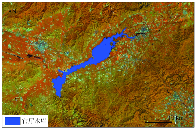
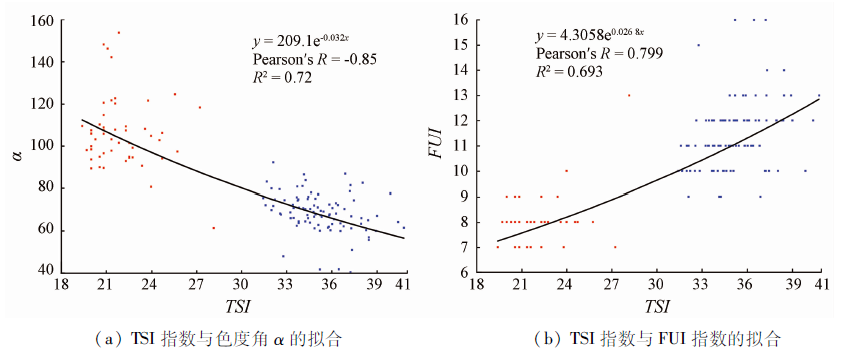
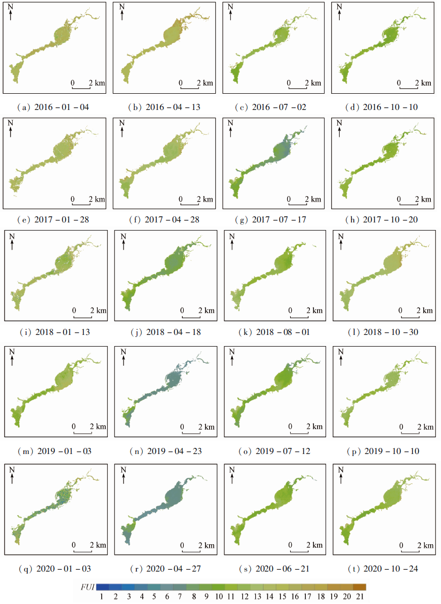
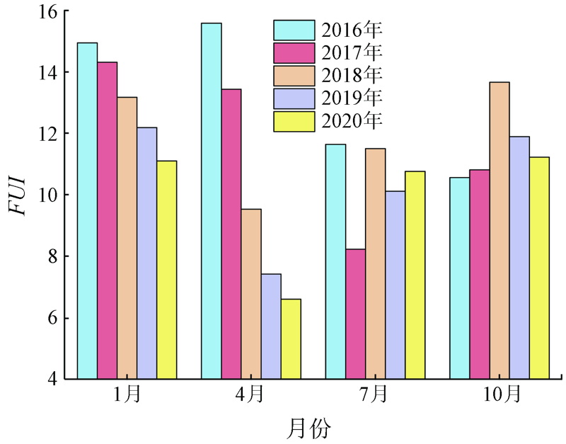
The quantitative characterization of water body color can provide important reference data for the comprehensive water quality assessment of inland lakes and reservoirs. The Guanting Reservoir is a large inland lake in North China. Based on FUI inversion using the seasonal-scale Sentinel-2 and Landsat 8 OLI reflectance data during 2016—2020, this study quantitatively analyzed the heterogeneous characteristics of Forel-Ule Index (FUI) of the Guanting Reservoir on the spatial, intra-annual, and inter-annual scales. To explore the coupling relationship between the FUI and the nutrient status of the water body, models were built using both hue angle α and FUI and the trophic status index (TSI). Moreover, this study demonstrated the comparability of FUI among different sensors and its application potential. The results are as follows. ① On the spatial scale, the FUI value was low at the center but high on the edge of the reservoir. ② On the seasonal scale within a year, the FUI value showed a trend of reaching the highest in winter, slightly decreasing in spring, reaching the lowest in summer, and rising again in autumn. ③ On the interannual scale, the FUI value in the latest three years was lower than that in the first two years during 2016—2020 and the water color changed accordingly from yellowish brown to yellowish green. These may be attributable to the effective governance of the Guanting Reservoir by the Beijing Municipal Government. ④ The Pearson correlation coefficient between TSI and α and that between TSI and FUI were -0.85 and 0.80, respectively, indicating a strong correlation between FUI and TSI. ⑤ The FUI values obtained through the inversion based on the Sentinel-2 and Landsat 8 OLI images of the same day were very approximate and were 13.04 and 13.16, respectively. This indicates that FUI is comparable between the images from different sensors. Therefore, the inversion of FUI can be achieved using the long time-series remote sensing data from multiple sensors. Meanwhile, FUI possesses notable application potential and advantages in the assessment of water quality and trophic status.
王一飞, 宫兆宁, 张园, 苏朔. 基于多源传感器的FUI水色指数提取与应用[J]. 自然资源遥感, 2021, 33(3): 262-271.
WANG Yifei, GONG Zhaoning, ZHANG Yuan, SU Shuo. Extraction and application of Forel-Ule index based on images from multiple sensors. Remote Sensing for Natural Resources, 2021, 33(3): 262-271.
Tab.2 基于波段线性插值的Sentinel-2,Landsat8 OLI 传感器色度角αM的Δα偏差校正多项式系数(a=αM/100)
Fig.5 基于实测叶绿素a浓度的TSI营养状态指数分别与色度角α及FUI的拟合
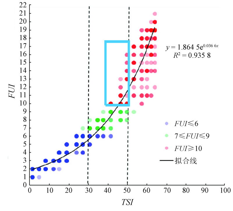
Fig.6 IOCCG模拟数据集(N=500)中的FUI与TSI之间的关系[32]
Fig.7 官厅水库FUI的季节性变化
Fig.8 官厅水库各季度FUI平均数值
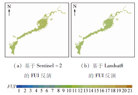
Fig.9 Sentinel-2与Landsat8 OLI反演FUI指数结果对比
[1]
Allan J D, McIntyre P B, Smith S D D, et al. Joint analysis of stressors and ecosystem services to enhance restoration effectiveness[J]. Proceedings of the National Academy of Sciences, 2013, 110(1):372-377.
doi: 10.1073/pnas.1213841110
[2]
Guan Q, Feng L, Hou X, et al. Eutrophication changes in fifty large lakes on the Yangtze Plain of China derived from MERIS and OLCI observations[J]. Remote Sensing of Environment, 2020, 246:111890.
doi: 10.1016/j.rse.2020.111890
[3]
Feng L, Hou X, Zheng Y. Monitoring and understanding the water transparency changes of fifty large lakes on the Yangtze Plain based on long-term MODIS observations[J]. Remote Sensing of Environment, 2019, 221:675-686.
doi: 10.1016/j.rse.2018.12.007
[4]
Bukata R P. Retrospection and introspection on remote sensing of inland water quality:“Like Déjà Vu All Over Again”[J]. Journal of Great Lakes Research, 2013(39):2-5.
Gong P. Expanding and deepening the application of remote sensing to environmental change in China[J]. Chinese Science Bulletin, 2012, 57(16):1379-1387.
Wang M C, Liu X Q, Zhang J H. Evaluate method and classification standard on lake eutrophication[J]. Environmental Monitoring in China, 2002(5):47-49.
[7]
Carlson R E. A trophic state index for lakes 1[J]. Limnology and Oceanography, 1977, 22(2):361-369.
doi: 10.4319/lo.1977.22.2.0361
[8]
Carlson R E. Expanding the trophic state concept to identify non-nutrient limited lakes and reservoirs[J]. Enhancing the States’s Lake Management Programs, 1991:59-71.
[9]
Sheela A M, Letha J, Joseph S, et al. Trophic state index of a lake system using IRS (P6-LISS III) satellite imagery[J]. Environmental Monitoring and Assessment, 2011, 177(1):575-592.
doi: 10.1007/s10661-010-1658-2
[10]
Joniak T, Nagengast B, Kuczyńska-Kippen N. Can popular systems of trophic classification be used for small water bodies?[J]. Oceanological and Hydrobiological Studies, 2009, 38(4):145-151.
doi: 10.2478/v10009-009-0053-1
[11]
Sathyendranath S. Reports of the international ocean-colour coordinating group[R]. IOCCG, 2000.
[12]
Novoa S, Wernand M R, Van der Woerd H J. The Forel-Ule scale revisited spectrally:Preparation protocol,transmission measurements and chromaticity[J]. Journal of the European Optical Society-Rapid publications, 2013, 8.
[13]
Wernand M R, Van der Woerd H J. Spectral analysis of the Forel-Ule Ocean colour comparator scale[J]. Journal of the European Optical Society-Rapid Publications, 2010, 5.
[14]
Wernand M R, Van der Woerd H J, Gieskes W W C. Trends in ocean colour and chlorophyll concentration from 1889 to 2000,worldwide[J]. PLOS One, 2013, 8(6):e63766.
doi: 10.1371/journal.pone.0063766
[15]
Wernand M R, Hommersom A, Van der Woerd H J. MERIS-based ocean colour classification with the discrete Forel-Ule scale[J]. Ocean Science, 2013, 9(3):477-487.
doi: 10.5194/os-9-477-2013
[16]
Li J, Wang S, Wu Y, et al. MODIS observations of water color of the largest 10 lakes in China between 2000 and 2012[J]. International Journal of Digital Earth, 2016, 9(8):788-805.
doi: 10.1080/17538947.2016.1139637
[17]
Chen Q, Huang M, Tang X. Eutrophication assessment of seasonal urban lakes in China Yangtze River Basin using Landsat 8-derived Forel-Ule index:A six-year (2013—2018) observation[J]. Science of The Total Environment, 2019: 135392.
Wang X, Gong Z N, Jing R, et al. Extraction of aquatic plants based on continuous removal method and analysis of its temporal and spatial changes:A case study of Guanting Reservoir[J]. Chinese Journal of Plant Ecology, 2018, 42(6):640-652.
doi: 10.17521/cjpe.2017.0240
[19]
吴世民, 王芸. 北京水史[M]. 北京: 中国水利水电出版社, 2013.
Wu S M, Wang Y. Beijing water history[M]. Beijing: China Water & Power Press, 2013.
Yu Z X, Ma D C. Countermeasures for reservoir water quality control under new situation:A case of Guanting Reservoir[J]. Water Resources Development Research, 2019, 19(10):57-61,79.
Tang J W, Tian G L, Wang X Y, et al. The methods of water spectra measurement and analysis Ⅰ:Above-water method[J]. Journal of Remote Sensing, 2004(1):37-44.
[22]
Mobley C D. Estimation of the remote-sensing reflectance from above-surface measurements[J]. Applied Optics, 1999, 38(36):7442-7455.
pmid: 18324298
Su W, Zhang M Z, Jiang K P, et al. Atmospheric correction method for Sentinel-2 satellite imagery[J]. Acta Optica Sinica, 2018, 38(1):322-331.
[24]
Cooley T, Anderson G P, Felde G W, et al. FLAASH,a MODTRAN4-based atmospheric correction algorithm,its application and validation[C]// IEEE International Geoscience and Remote Sensing Symposium.IEEE, 2002: 7528709.
Yuan J G, Niu Z, Wang X P. Atmospheric correction of Hyperion hyperspectral image based on FLAASH[J]. Spectroscopy and Spectral Analysis, 2009, 29(5):1181-1185.
[26]
Mcfeeters S K. The use of the normalized difference water index (NDWI) in the delineation of open water features[J]. International Journal of Remote Sensing, 1996, 17(7):1425-1432.
doi: 10.1080/01431169608948714
[27]
Smith T, Guild J. The CIE colorimetric standards and their use[J]. Transactions of the Optical Society, 1931, 33(3):73.
doi: 10.1088/1475-4878/33/3/301
[28]
Woerd H J, Wernand M R. True colour classification of natural waters with medium-spectral resolution satellites:SeaWiFS,MODIS,MERIS and OLCI[J]. Sensors, 2015, 15(10):25663-25680.
doi: 10.3390/s151025663
[29]
Van der Woerd H J, Wernand M R. Hue-angle product for low to medium spatial resolution optical satellite sensors[J]. Remote Sensing, 2018, 10(2):180.
doi: 10.3390/rs10020180
[30]
Benesty J, Chen J, Huang Y, et al. Pearson correlation coefficient[M]// Noise Reduction in Speech Processing.Springer,Berlin,Heidelberg, 2009:1-4.
[31]
Lee Z P. Remote sensing of inherent optical properties:Fundamentals,tests of algorithms,and applications[R]. IOCCG, 2006.
[32]
Wang S, Li J, Zhang B, et al. Trophic state assessment of global inland waters using a MODIS-derived Forel-Ule index[J]. Remote Sensing of Environment, 2018, 217:444-460.
doi: 10.1016/j.rse.2018.08.026
 2021, Vol. 33
  ), 宫兆宁1,2,3,4(