Aquatic environmental monitoring of inland waters based on UAV hyperspectral remote sensing
ZANG Chuankai1(), SHEN Fang1,2(), YANG Zhengdong3
1. State Key Laboratory of Estuarine and Coastal Research, East China Normal University, Shanghai 200062, China 2. Institute of Eco-Chongming(IEC), Shanghai 200062, China 3. Hydrological Station of Shanghai Chongming District, Shanghai 200062, China
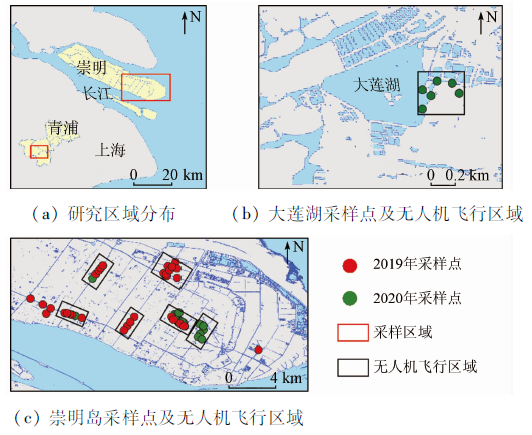
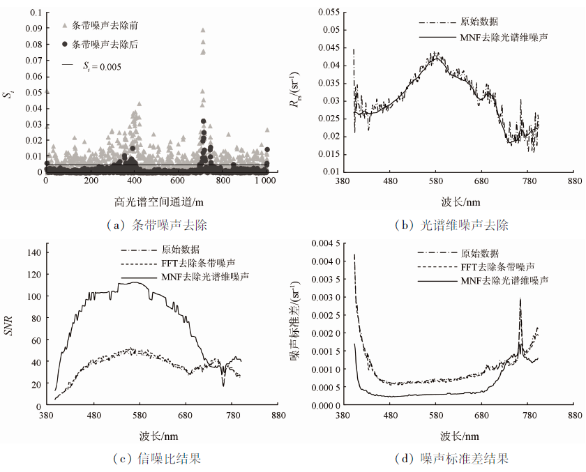
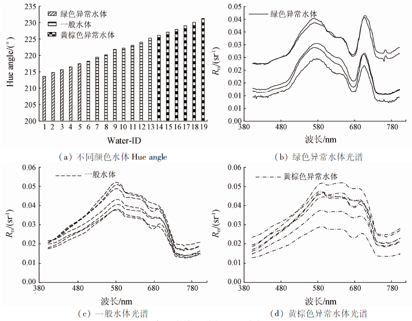
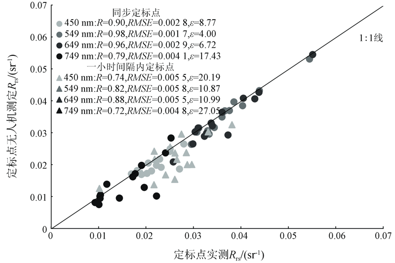
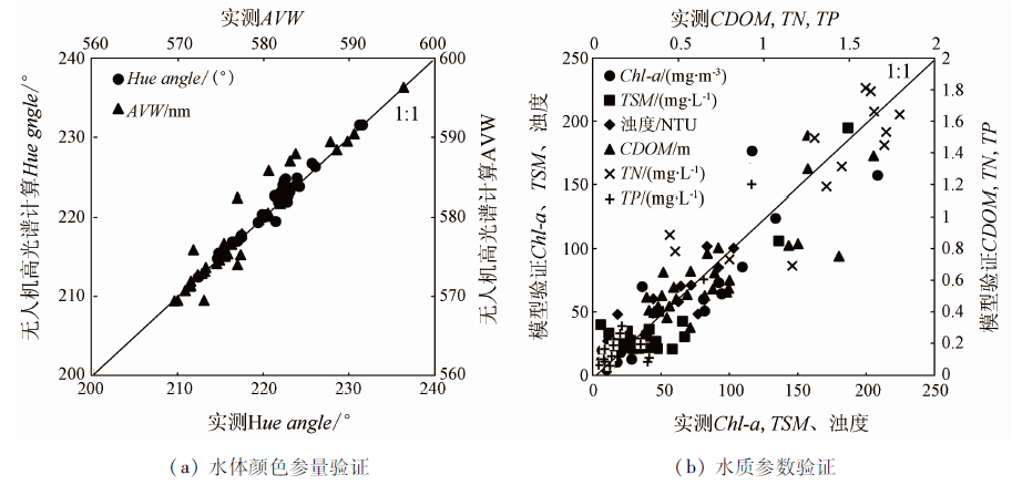
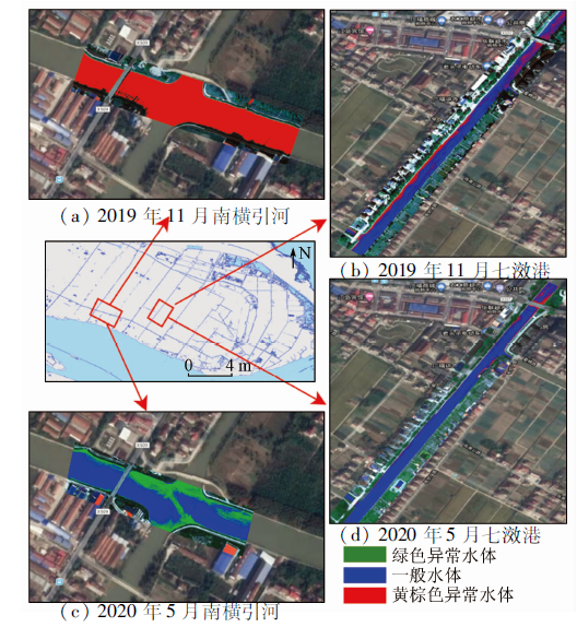
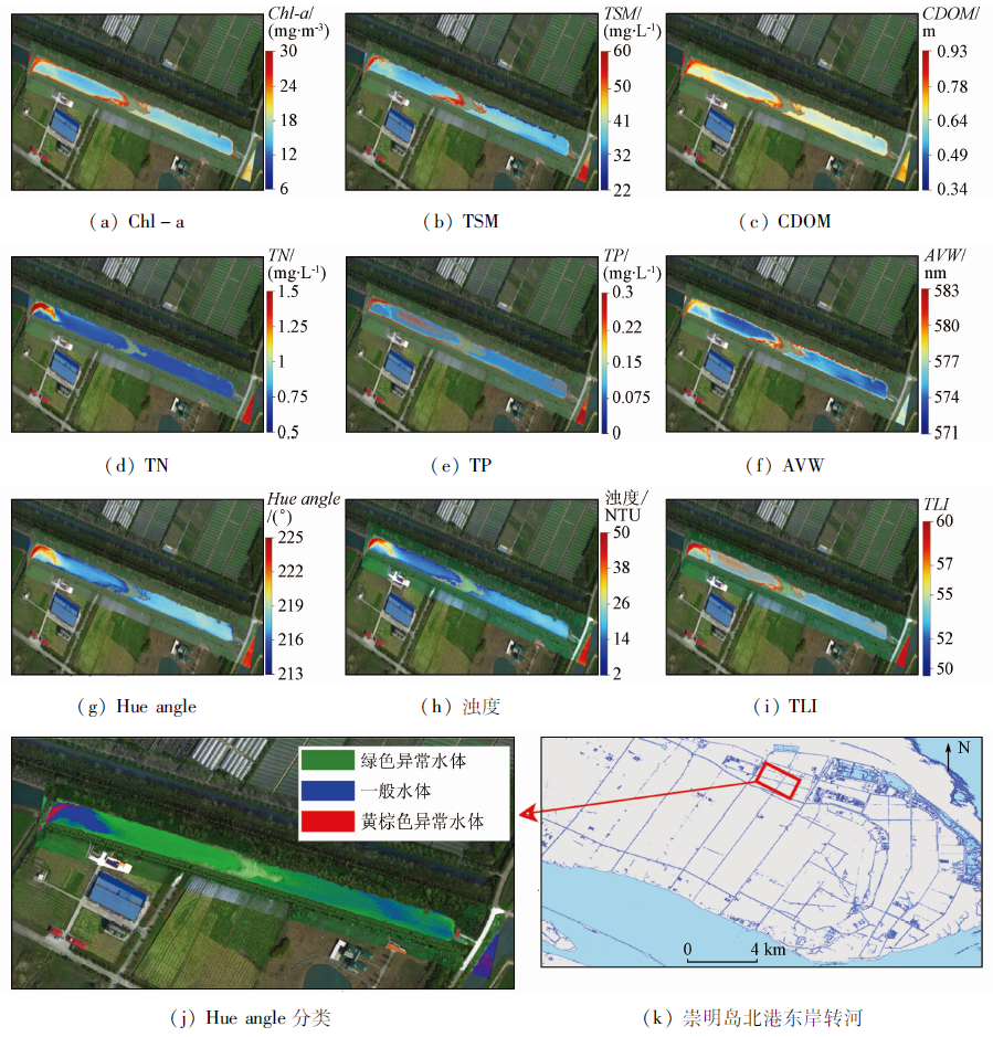
With the inland waters in Chongming Island, Shanghai as the study area, this study researched the color changes of waters and the identification of suspected polluted waters using unmanned aerial vehicle (UAV) hyperspectral remote sensing images. First, reflectance calibration was carried out for the radiance signals detected by the hyperspectral sensor carried by UAVs. Compared with on-site observations, this calibration method was more accurate, the average unbiased absolute percentage differences of various bands were 13.34% on average and the average determination coefficient R2 was 0.83. Afterward, the inversion of hue angle and apparent visible wavelength (AVW) was conducted using the hyperspectral reflectance of the inland waters according to the CIE-XYZ color space and weighted harmonic mean. Then an inversion model of water quality parameters was constructed based on measured data, and the water colors in the study area were classified by setting the threshold of hue angle. As indicated by the results, there exist many abnormal yellowish-brown inland waters in the Chongming Island in dry seasons and it is necessary to strengthen the supervision and governance of the aquatic environment of major shipping rivers. Finally, the suspected polluted inland waters were identified and analyzed by integrating the inversion results of the parameters of water color and water quality. This study shows that UAV hyperspectral remote sensing can be used to obtain the inversion results with high temporal-spatial continuity of the parameters of water color and water quality, which will provide credible technical support for the aquatic environment investigations of inland waters while saving costs.
Chen W Z, Li G M, Xu J C, et al. Application of remote sensing technology in water environment monitoring[J]. Environmental Monitoring in China, 2008(3):6-11.
[2]
Dall’olmo G, Gitelson A A, Rundquist D C. Towards a unified approach for remote estimation of chlorophyll-a in both terrestrial vegetation and turbid productive waters[J]. Geophysical Research Letters, 2003, 30(18):1938-1942.
[3]
Nechard B, Ruddick K G, Park Y. Calibration and validation of a generic multisensor algorithm for mapping of total suspended matter in turbid waters[J]. Remote Sensing of Environment, 2010, 114(4):854-866.
doi: 10.1016/j.rse.2009.11.022
[4]
Duan H, Ma R, Loiselle S A, et al. Optical characterization of black water blooms in eutrophic waters[J]. Science of The Total Environment, 2014, 482-483:174-183.
doi: 10.1016/j.scitotenv.2014.02.113
[5]
Wernand M R, Hommersom A, Woerd H J V D. MERIS-based ocean colour classification with the discrete Forel-Ule scale[J]. Ocean Science, 2013, 9(3):477-487.
doi: 10.5194/os-9-477-2013
[6]
CIE. Commission Internationale de l'Eclairage(CIE)Proceedings 1931[M]. Cambridge: Cambridge University Press, 1932.
[7]
Woerd H J V D, Wernand M R. Hue-angle product for low to medium spatial resolution optical satellite sensors[J]. Remote Sensing, 2018, 10(2):180-198.
doi: 10.3390/rs10020180
[8]
Woerd H J V D, Wernand M R. True colour classification of natural waters with medium-spectral resolution satellites:SeaWiFS,MODIS,MERIS and OLCI[J]. Sensors (Basel), 2015, 15(10):25663-25680.
doi: 10.3390/s151025663
[9]
Wang S, Li J, Zhang B, et al. Trophic state assessment of global inland waters using a MODIS-derived Forel-Ule index[J]. Remote Sensing of Environment, 2018, 217:444-460.
doi: 10.1016/j.rse.2018.08.026
[10]
Wang S, Li J, Shen Q, et al. MODIS-Based radiometric color extraction and classification of inland water with the forel-ule scale:A case study of Lake Taihu[J]. IEEE Journal of Selected Topics in Applied Earth Observations and Remote Sensing, 2015, 8(2):907-918.
doi: 10.1109/JSTARS.4609443
[11]
Zhao Y, Shen Q, Wang Q, et al. Recognition of water colour anomaly by using hue angle and Sentinel 2 image[J]. Remote Sensing, 2020, 12(4):716-737.
doi: 10.3390/rs12040716
[12]
Vandermeulen R A, Mannino A, Craig S E, et al. 150 shades of green:Using the full spectrum of remote sensing reflectance to elucidate color shifts in the ocean[J]. Remote Sensing of Environment, 2020, 247:111900.
doi: 10.1016/j.rse.2020.111900
[13]
Zhang F, Li J, Shen Q, et al. Algorithms and schemes for Chlorophyll a estimation by remote sensing and optical classification for Turbid Lake Taihu,China[J]. IEEE Journal of Selected Topics in Applied Earth Observations and Remote Sensing, 2015, 8(1):350-364.
doi: 10.1109/JSTARS.4609443
[14]
Tan J, Cherkauer K A, Chaubey I. Using hyperspectral data to quantify water-quality parameters in the Wabash River and its tributaries,Indiana[J]. International Journal of Remote Sensing, 2015, 36(21):5466-5484.
doi: 10.1080/01431161.2015.1101654
Sun D Y, Li Y M, Wang Q, et al. Remote sensing retrieval of CDOM concentration in Lake Taihu with hyper-spectral data and neural network model[J]. Geomatics and Information Science of Wuhan University, 2009, 34(7):851-855.
Zhang Y C, Jiang D G, Li J H, et al. Characteristics of eutrophication and its affecting factors in gate-controlled river network system of Chongming Island[J]. Journal of Lake Sciences, 2013, 25(3):366-372.
doi: 10.18307/2013.0309
Zhu H, Liu X G, Wu Z F, et al. Assessment of eutrophication and N,P balance in Dalian Lake ecological restoration region of Shanghai City[J]. Bulletin of Soil and Water Conservation, 2013, 33(6):157-160.
Tang J W, Tian G L, Wang X Y, et al. The Methods of water spectra measurement and analysis I:Above-water method[J]. Journal of Remote Sensing, 2004(1):37-44.
National Environmental Protection Agency. HJ/T 91—2002 Environmental quality standards for surface water[S]. Beijing: China Environmental Press, 2002
[20]
Porra R J. The chequered history of the development and use of simultaneous equations for the accurate determination of chlorophylls a and b[J]. Photosynth Res, 2002, 73(1-3):149-156.
doi: 10.1023/A:1020470224740
[21]
Bricaud A, Morel A, Prieur L. Absorption by dissolved organic matter of the sea (Yellow Substance) in the UV and visible domains[J]. Limnology and Oceanography, 1981, 26(1):43-53.
doi: 10.4319/lo.1981.26.1.0043
National Environmental Protection Agency. HJ 636—2012 Water quality-determination of total nitrogen-alkaline potassium persulfate digestion-ultraviolet spectrophotometric method[S]. Beijing: China Environmental Press, 2012.
National Environmental Protection Agency. GB-11893—89 Water quality-Determination of total phosphorus-Ammonium molybdate spectrophotometric method[S]. Beijing: China Environmental Press, 1990.
National Environmental Protection Agency. GB-11901—89 Water quality-determination of suspended matter gravimetric method [S]. Beijing: China Environmental Press. 1990.
Gou Z Y, Yan L, Chen W, et al. In-Flight Absolute Radiometric calibration of UAV hyperspectral camera and its validation analysis[J]. Spectroscpy and Spectral Analysis, 2012, 32(2):430-434.
[26]
Slater P N, Biggar S F, Holm R G, et al. Reflectance-and radiance-based methods for the in.flight absolute calibration of multispectral sensors[J]. Remote Sensing of Environment, 1987(22):11-37.
[27]
Shang S, Lee Z, Lin G, et al. Sensing an intense phytoplankton bloom in the western Taiwan Strait from radiometric measurements on a UAV[J]. Remote Sensing of Environment, 2017, 198:85-94.
doi: 10.1016/j.rse.2017.05.036
[28]
Mobley C D. Light and water:Radiative transfer in natural waters[M]. USA: Academic Press, 1994.
[29]
Yang J, Liu C, Shu R, et al. The extraction of urban surface water from hyperspectral data based on spectral indices[J]. Journal of the Indian Society of Remote Sensing, 2018, 46(11):1749-1759.
doi: 10.1007/s12524-018-0828-5
Liu X. Target detection on hyperspectral imagery based on transformation of spectral dimensions[D]. Beijing:Institute of Remote Sensing Applications Chinese Academy of Sciences, 2008.
[31]
Brigham E O, Morrow E R. The fast fourier transform[J]. Acoustics Speech&Signal Processing IEEE Transactions on, 2007, 4(12):63-70.
[32]
Landsat 8. Data Users Handbook Version 2.0.Department of the Interior[R]. Sioux Falls,South Dakota:USGS, 2016.
[33]
Green A A, Berman M, Switzer P, et al. A transformation for ordering multispectral data in terms of image quality with implications for noise removal[J]. IEEE Transactions on Geoscience and Remote Sensing, 1988, 26(1):65-74.
doi: 10.1109/36.3001
[34]
Gao B C. An operational method for estimating signal to noise ratios from data acquired with imaging spectrometers[J]. Remote Sensing of Environment, 1993, 43(1):23-33.
doi: 10.1016/0034-4257(93)90061-2
Wang M C, Liu X Q, Zhang J H. Evaluate method and classification standard on lake eutrophication[J]. China Environmental Monitoring Centre, 2002(5):47-49.
 2021, Vol. 33
  ), 沈芳1,2(