Please wait a minute...
 
国土资源遥感  2018, Vol. 30 Issue (2): 162-170    DOI: 10.6046/gtzyyg.2018.02.22
     技术应用 本期目录 | 过刊浏览 | 高级检索 |
甘肃红山地区重要控矿地质单元GF-1数据遥感解译与应用
王瑞军1(), 闫柏琨2, 李名松1, 董双发1, 孙永彬1, 汪冰1
1.核工业航测遥感中心,石家庄 050002
2.中国国土资源航空物探遥感中心,北京 100083
Remote sensing interpretation of important ore-controlling geological units in Hongshan Region of Gansu Province using GF-1 image and its application
Ruijun WANG1(), Bokun YAN2, Mingsong LI1, Shuangfa DONG1, Yongbin SUN1, Bing WANG1
1. Airborne Survey and Remote Sensing Center of Nuclear Industry, Shijiazhuang 050002, China
2. China Aero Geophysical Survey and Remote Sensing Center for Land and Resources, Beijing 100083, China
全文: PDF(5756 KB)   HTML  
输出: BibTeX | EndNote (RIS)      
摘要 

为了解高分一号(GF-1)卫星图像在地质找矿领域的应用性能,查明甘肃红山地区的成矿地质环境,利用GF-1图像对红山地区的控矿地层、构造和岩体进行遥感解译。在收集、梳理前人研究成果和野外验证的基础上,综合分析红山地区的成矿地质特征和规律,总结区内与多金属矿密切相关的地质体,建立该区重要控矿地层、控矿构造和控矿岩体的GF-1图像解译标志; 通过分析重要控矿地质单元的成矿地质特征和成矿规律,解析和挖掘典型矿床的控矿地质要素特征,整合典型矿床所处地质环境和控矿及赋矿要素信息,综合剖析典型多金属矿床的多源异常特征,构建找矿模型; 开展找矿应用,圈定遥感找矿有利地段。经野外查证,新发现铜、钼、铁、锌等多金属矿化线索,均位于GF-1图像解译的重要控矿地质单元区,取得了较好的找矿成果,表明国产卫星数据能够很好地应用于地质矿产勘查领域。

服务
把本文推荐给朋友
加入引用管理器
E-mail Alert
RSS
作者相关文章
王瑞军
闫柏琨
李名松
董双发
孙永彬
汪冰
关键词 高分一号(GF-1)卫星重要控矿地质单元遥感解译找矿应用红山地区    
Abstract

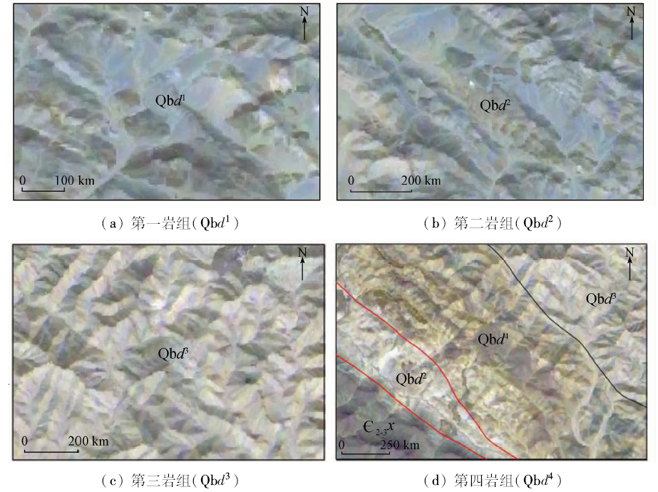
For the purpose of understanding the performance of the high resolution satellite image in the geological prospecting field and finding out the metallogenic geological environment of Hongshan Region in Gansu Province, the authors interpreted the ore-controlling strata, structures and rock masses in Hongshan Region by using the Gaofen-1 satellite(GF-1)remote sensing images. On the basis of reviewing and summarizing the results of previous studies and field verification, the geological characteristics and metallogenic regularity of Hongshan Region were analyzed comprehensively, the geological bodies closely related to the polymetallic deposit were summarized, and the GF-1 image interpretation keys of the important ore-controlling strata, ore controlling structure and ore rock were established. Based on the analysis of metallogenic geological characteristics and metallogenic regularity of the important ore-controlling geological units, the authors analyzed and excavated the characteristics of the ore-controlling geological factors of typical ore deposits, integrated the geological environment of the typical ore deposits and ore-controlling information; the multi-source anomaly characteristics of the typical polymetallic deposit were comprehensively analyzed, and the ore-prospecting model was established. The remote sensing prospecting was carried out, and the favorable areas for prospecting were delineated. Copper, molybdenum, iron, zinc and other metal mineralization clues were newly discovered through the field investigation, which are located in the important ore- controlling geological units according to the GF-1 image interpretation, and the better results of prospecting were achieved. The results show that the domestic satellite data can obtain good application results in the field of geological mineral exploration.

Key wordsGaofen-1 satellite(GF-1)    important ore-controlling geological unit    remote sensing interpretation    ore prospecting application    Hongshan Region
收稿日期: 2016-09-19      出版日期: 2018-05-30
:  TP79P623.2  
基金资助:中国地质调查局地质调查项目“天山—北山重要成矿区带遥感调查”(编号: 121201003000150008)
引用本文:   
王瑞军, 闫柏琨, 李名松, 董双发, 孙永彬, 汪冰. 甘肃红山地区重要控矿地质单元GF-1数据遥感解译与应用[J]. 国土资源遥感, 2018, 30(2): 162-170.
Ruijun WANG, Bokun YAN, Mingsong LI, Shuangfa DONG, Yongbin SUN, Bing WANG. Remote sensing interpretation of important ore-controlling geological units in Hongshan Region of Gansu Province using GF-1 image and its application. Remote Sensing for Land & Resources, 2018, 30(2): 162-170.
链接本文:  
https://www.gtzyyg.com/CN/10.6046/gtzyyg.2018.02.22      或      https://www.gtzyyg.com/CN/Y2018/V30/I2/162
Fig.1  红山地区GF-1正射影像图(GF-1 B4(R),B3(G),B2(B)假彩色合成图像)
Fig.2  青白口系大豁落山群(Qbd)GF-1影像特征
Fig.3  震旦系泽鲁木群(Z1-2z)GF-1影像特征
Fig.4  寒武系西双鹰山群(∈2-3x)GF-1影像特征
Fig.5  志留纪岩体GF-1影像特征
Fig.6  褶皱构造GF-1影像特征
1.第四系全新统; 2.罗雅楚山群下岩组; 3.寒武系西双鹰山群; 4.震旦系泽鲁木群; 5.南华系洗肠井组; 6.青白口系大豁落山群第四岩组; 7.大豁落山群第三岩组; 8.大豁落山群第二岩组; 9.大豁落山群第一岩组; 10.蓟县系平头山群; 11.长城系古硐井群; 12.石英闪长岩; 13.英云闪长岩; 14.韧性剪切带; 15.正断层; 16.性质不明断层; 17.地质界线; 18.平行不整合界线; 19.角度不整合界线
Fig.7  断裂构造GF-1影像特征
验证重要控矿地质单元 验证点/个 正确点/个 误判点/个 正确率/% 误判率/%
控矿地层 青白口系大豁落山群 31 26 5 83.87 16.13
震旦系泽鲁木群 18 15 3 83.33 16.67
寒武系西双鹰山群 22 18 4 81.82 18.18
控矿岩体 志留纪基性—超基性岩 15 15 0 100.00 0.00
志留纪辉长—辉绿岩 16 16 0 100.00 0.00
其他岩脉 8 7 1 87.50 12.50
控矿构造 罗雅楚山背斜 26 24 2 92.31 7.69
砂井子东背斜 20 18 2 90.00 10.00
断裂 11 10 1 90.91 9.09
总计 167 149 18 89.22 10.78
Tab.1  重要控矿地质单元野外验证结果
模型结构 矿床模型 红山模型 黑山模型 大红山模型 七一模型 黑石尖模型
矿种类型 铁矿 铜镍矿 锰矿 磷钒铀矿 多金属矿
成因类型 沉积—变质型 岩浆熔离型 沉积—改造型 沉积—变质型 热液型
构造部位 NW向背斜构造 区域性近EW向断裂 近EW向断裂 NW向背斜构造 区域性NWW向—
近EW向断裂
赋矿部位 罗雅楚山背斜和
砂井子东背斜
分异强烈基性—
超基性杂岩体
罗雅楚山背斜南翼 罗雅楚山背斜 NEE向断裂
控矿地质单元 青白口系大豁落山群 志留纪基性—
超基性岩体
震旦系泽鲁木群 寒武系西双鹰山群 NEE向断裂
赋矿层位 青白口系大豁落山群 志留纪基性—
超基性岩体
震旦系泽鲁木群 寒武系西双鹰山群 NEE向断裂带
含矿地段 背斜轴部转折端部位 杂岩体及接触带 背斜南翼 背斜南翼 NEE向及次级断裂带
矿体围岩 顶板为石榴黑云石英片岩,
底板为黑云母石英片岩
角闪橄榄岩、
角闪辉长岩
杂色细碎屑夹碳酸盐岩 黑色炭质页岩—
硅质岩夹碳酸盐岩
变质碎屑岩
Tab.2  红山地区典型矿床找矿模型
Fig.8  红山地区遥感找矿有利地段分布
1.全新统: 砂砾土; 2.奥陶系锡林柯博组: 凝灰质砂岩、粉砂岩; 3.奥陶系罗雅楚山群下岩组: 石英砂岩、粉砂岩; 4.寒武系西双鹰山群: 砂质板岩、石英岩; 5.震旦系泽鲁木群: 大理岩、板岩; 6.南华系洗肠井群: 大理岩、粉砂岩; 7.青白口系大豁落山群第四岩组: 千枚岩、石英岩夹磁铁矿层; 8.第三岩组: 大理岩、板岩; 9.第二岩组: 灰岩、石英砂岩; 10.第一岩组: 大理岩、片岩; 11.蓟县系平头山群: 大理岩、白云岩、石英岩; 12.泥盆纪二长花岗岩; 13.泥盆纪石英闪长岩; 14.志留纪花岗闪长岩; 15.志留纪英云闪长岩; 16.志留纪斜长角闪岩; 17.志留纪辉长—辉绿岩; 18.志留纪角闪橄榄岩; 19.辉绿岩脉; 20.断裂构造; 21.韧性剪切带; 22.地质界线; 23.地层产状; 24.与控矿地层密切相关的找矿有利地段; 25.与控矿构造密切相关的找矿有利地段; 26.与控矿岩体密切相关的找矿有利地段
Fig.9  铜钼矿化线索区野外实地照片
[1] 王润生, 熊盛青, 聂洪峰 , 等. 遥感地质勘查技术与应用研究[J]. 地质学报, 2011,85(11):1699-1743.
Wang R S, Xiong S Q, Nie H F , et al. Remote sensing technology and its application in geological exploration[J]. Acta Geologica Sinica, 2011,85(11):1699-1743.
[2] 张焜, 马世斌, 李宗仁 , 等. 高分一号卫星数据遥感地质解译[J]. 遥感信息, 2016,31(1):115-123.
doi: 10.3969/j.issn.1000-3177.2016.01.019
Zhang K, Ma S B, Li Z R , et al. Geological interpretation of GF-1 satellite imagery[J]. Remote Sensing Information, 2016,31(1):115-123.
[3] 何凯涛, 甘甫平, 王永江 . 高空间分辨率卫星遥感地质微构造及蚀变信息识别[J]. 国土资源遥感, 2009,21(1):97-99.doi: 10.6046/gtayyg.2009.01.22.
doi: 10.6046/gtzyyg.2009.01.22
He K T, Gan F P, Wang Y J . The extraction of geological micro-structure and altered rock information with high-resolution satellite images in a small range[J]. Remote Sensing for Land and Resources, 2009,21(1):97-99.
[4] 叶发旺, 刘德长 . 巴什布拉克铀矿区褪色蚀变Quickbird高分图像地学分析[J]. 地球信息科学学报, 2012,14(1):123-127.
doi: 10.3724/SP.J.1047.2012.00123
Ye F W, Liu D C . Analysis on the fading alteration in Bashibulake uranium mineralization area using Quickbird high resolution satellite remote sensing data[J]. Journal of Geo-information Science, 2012,14(1):123-127.
[5] 叶发旺, 刘德长 . 新疆塔里木盆地北缘铀矿勘查中高分辨率遥感分析应用[J]. 地球信息科学学报, 2012,14(4):548-554.
Ye F W, Liu D C . Application of high resolution remote sensing technology to uranium ore exploration in North Fringe of Tarim Basin,Xingjiang,China[J]. Journal of Geo-information Science, 2012,14(4):548-554.
[6] 陈玲, 张微, 周艳 , 等. 高分辨率遥感影像在新疆塔什库尔干地区沉积变质型铁矿勘查中的应用[J]. 地质与勘探, 2012,48(5):1039-1048.
Chen L, Zhang W, Zhou Y , et al. Application of high-resolution remote sensing images to searching for sedimentary-metamorphic type iron deposits in the Taxkorgan Area,Xinjiang[J]. Geology and Exploration, 2012,48(5):1039-1048.
[7] 金剑, 田淑芳, 焦润成 , 等. 基于地物光谱分析的WorldView-2数据岩性识别:以新疆乌鲁克萨依地区为例[J]. 现代地质, 2013,27(2):489-496.
doi: 10.3969/j.issn.1000-8527.2013.02.031
Jin J, Tian S F, Jiao R C , et al. Lithology identification with WorldView-2 data based on spectral analysis of surface features:A case study of Wulukesayi District in Xinjiang[J]. Geoscience, 2013,27(2):489-496.
[8] 王晓鹏, 杨志强, 康高峰 , 等. WorldView-2高分辨率卫星数据在西昆仑塔什库尔干地区遥感地质调查中的应用[J]. 地质找矿论丛, 2014,29(3):428-432.
doi: 10.6053/j.issn.1001-1412.2014.03.018
Wang X P.Yang Z Q, Kang G F , et al. Application of WorldView-2 data to remote sensing geological survey in Tashkurgan Area at West Kunlun[J]. Contributions to Geology and Mineral Resources Research, 2014,29(3):428-432.
[9] 金谋顺, 王辉, 乔耿彪 , 等. 利用高分遥感技术发现西昆仑黑恰铁矿矿化带及其地质意义[J]. 西北地质, 2014,47(4):221-226.
Jin M S.Wang H, Qiao G B , et al. The discovery of Heiqia iron mineralization belt in West Kunlun by high resolution remote sensing technology and its geological significance[J]. Northwestern Geology, 2014,47(4):221-226.
[10] 焦润成, 秦彦平, 张淑云 , 等. Worldview-2数据在沉积岩地区的遥感岩性增强方法初探——以新疆喀什阿尔塔什地区为例[J]. 西北地质, 2014,47(4):277-283.
Jiao R C, Qin Y P, Zhang S Y , et al. A preliminary exploration of methods to enhance remote sensing lithology with Worldview-2 data in sedimentary rocks area:A case study in Kashi Altas District of Xinjiang[J]. Northwestern Geology, 2014,47(4):277-283.
[11] 路云阁, 刘采, 王姣 . 基于国产卫星数据的矿山遥感监测一体化解决方案——以西藏自治区为例[J]. 国土资源遥感, 2014,26(4):85-90.doi: 10.6046/gtzyyg.2014.04.14.
doi: 10.6046/gtzyyg.2014.04.14
Lu Y G, Liu C, Wang J . Integrated solutions for mine remote sensing monitoring based on domestic satellite images:A case study of Tibet[J]. Remote Sensing for Land and Resources, 2014,26(4):85-90.doi: 10.6046/gtzyyg.2014.04.14.
[12] 陈玲, 梁树能, 周艳 , 等. 国产高分卫星数据在高海拔地区地质调查中的应用潜力分析[J]. 国土资源遥感, 2015,27(1):140-145.doi: 10.6046/gtzyyg.2015.01.22.
doi: 10.6046/gtzyyg.2015.01.22
Chen L, Liang S N, Zhou Y , et al. Potential of applying domestic high-resolution remote sensing data to geological survey in high altitudes[J]. Remote Sensing for Land and Resources, 2015,27(1):140-145.doi: 10.6046/gtzyyg.2015.01.22.
[13] 张发荣, 牛卯胜 . 甘肃北山地区成矿带划分及基本特征[J]. 甘肃地质学报, 2003,12(1):50-57.
Zhang F R, Niu M S . Divisions and basic features of the metallogenic belts in Beishan Area of Gansu Province[J]. Acta Geologica Gansu, 2003,12(1):50-57.
[14] 彭巨贵, 张发荣, 赵福昌 . 甘新蒙北山地区成矿带划分和基本特征对比[J]. 地球科学与环境学报, 2006,28(3):11-18.
doi: 10.3969/j.issn.1672-6561.2006.03.003
Peng J G, Zhang F R, Zhao F C . Divisions and contrast of basic features of metallogenic belts in Beishan Area of Gansu-Xinjiang-Iner Mongolia[J]. Journal of Earth Sciences and Environment, 2006,28(3):11-18.
[15] 李文渊, 董福辰, 姜寒冰 , 等. 西北地区重要金属矿产成矿特征及其找矿潜力[J]. 西北地质, 2006,39(2):1-16.
Li W Y, Dong F Z, Jiang H B , et al. Metallogenetic characteristics and prospecting potential of major metallic minerals in Northwest China[J]. Northwestern Geology, 2006,39(2):1-16.
[16] 张焜, 李晓民, 马世斌 , 等. GF-1图像在中印边境楚鲁松杰村地质灾害调查中的应用[J]. 国土资源遥感, 2016,28(2):139-148.doi: 10.6046/gtzyyg.2016.02.22.
doi: 10.6046/gtzyyg.2016.02.22
Zhang K, Li X M, Ma S B , et al. Application of GF-1 image to geological disaster survey in cosibsumgy village on Sino - India border area[J]. Remote Sensing for Land and Resources, 2016,28(2):139-148.doi: 10.6046/gtzyyg.2016.02.22.
[17] 杨日红, 于学政 . 藏东三江地区遥感五要素模式找矿远景[J]. 现代地质, 2004,18(4):543-548.
doi: 10.3969/j.issn.1000-8527.2004.04.021
Yang R H, Yu X Z . The mineral-prospecting perspective of remote sensing five features model in the Three-River Area of East Tibet[J]. Geoscience, 2004,18(4):543-548.
[18] 张微, 金谋顺, 张少鹏 , 等. 高分遥感卫星数据在东昆仑成矿带找矿预测中的应用[J]. 国土资源遥感, 2016,28(2):112-119.doi: 10.6046/gtzyyg.2016.02.18.
doi: 10.6046/gtzyyg.2016.02.18
Zhang W, Jin M S, Zhang S P , et al. Application of high resolution remote sensing data to ore-prospecting prediction in East Kunlun metallogenic belt[J]. Remote Sensing for Land and Resources, 2016,28(2):112-119.doi: 10.6046/gtzyyg.2016.02.18.
[19] 杨金中, 王海庆, 陈微 . 西昆仑成矿带高分辨率遥感调查主要进展与成果[J]. 中国地质调查, 2016,3(5):7-12.
Yang J Z, Wang H Q, Chen W . Main progress and achievements of high spacial resolution remote sensing survey on west Kunlun metallorgenic belt[J]. Geological Survey of China, 2016,3(5):7-12.
[1] 刘志中, 宋英旭, 叶润青. 渝东北2014年“8·31”暴雨诱发滑坡遥感解译与分析[J]. 自然资源遥感, 2021, 33(4): 192-199.
[2] 付丽华, 张策. 基于高分遥感数据的西藏荣勒地区控矿信息提取[J]. 国土资源遥感, 2020, 32(1): 98-105.
[3] 谢小平, 白毛伟, 陈芝聪, 柳伟波, 席书娜. 龙门山断裂带北东段活动断裂的遥感影像解译及构造活动性分析[J]. 国土资源遥感, 2019, 31(1): 237-246.
[4] 随欣欣, 眭素文. 基于MapGIS和ArcGIS的遥感解译成果图件数据库设计与实现[J]. 国土资源遥感, 2018, 30(4): 218-224.
[5] 随欣欣, 眭素文, 刘锟. 面向遥感业务应用的解译成果数据管理系统研究和构建[J]. 国土资源遥感, 2018, 30(3): 238-243.
[6] 张策, 揭文辉, 付丽华, 魏本赞. 新疆新源县滑坡灾害遥感影像特征及分布规律[J]. 国土资源遥感, 2017, 29(s1): 81-84.
[7] 李海鹰. 国产高分辨率遥感数据在环境地质调查中的应用[J]. 国土资源遥感, 2017, 29(s1): 46-51.
[8] 王瑞军, 董双发, 孙永彬, 李婧玥. 基于高分一号卫星数据新疆索拉克地区控矿地质单元遥感解译与应用[J]. 国土资源遥感, 2017, 29(s1): 137-143.
[9] 李晓民, 张焜, 李冬玲, 李得林, 李宗仁, 张兴. 青藏高原札达地区多年冻土遥感技术圈定方法与应用[J]. 国土资源遥感, 2017, 29(1): 57-64.
[10] 李晓民, 燕云鹏, 刘刚, 李冬玲, 张兴, 庄永成. ZY-1 02C星数据在西藏札达地区水文地质调查中的应用[J]. 国土资源遥感, 2016, 28(4): 141-148.
[11] 高孟绪, 王卷乐, 柏中强, 祝俊祥. 基于RapidEye影像的农村居民地遥感监测——以江西省泰和县为例[J]. 国土资源遥感, 2016, 28(1): 130-135.
[12] 宿渊源, 张景发, 何仲太, 姜文亮, 蒋洪波, 李强. 资源卫星三号DEM数据在活动构造定量研究中的应用评价[J]. 国土资源遥感, 2015, 27(4): 122-130.
[13] 刘德长, 童勤龙, 林子喻, 杨国防. 欧洲大陆遥感地质解译、诠释与矿产勘查战略选区[J]. 国土资源遥感, 2015, 27(3): 136-143.
[14] 胥兵, 方臣. ZY-102C星图像与ETM+图像融合方法及效果评价[J]. 国土资源遥感, 2014, 26(3): 80-85.
[15] 徐岳仁, 何宏林, 陈立泽, 申旭辉. 基于CBERS数据的福建南平地质灾害动态遥感解译[J]. 国土资源遥感, 2014, 26(3): 153-159.
Viewed
Full text


Abstract

Cited

  Shared   
  Discussed   
京ICP备05055290号-2
版权所有 © 2015 《自然资源遥感》编辑部
地址:北京学院路31号中国国土资源航空物探遥感中心 邮编:100083
电话:010-62060291/62060292 E-mail:zrzyyg@163.com
本系统由北京玛格泰克科技发展有限公司设计开发