1. School of Information Engineering, China University of Geosciences(Beijing), Beijing 100083, China 2. Ningxia Geological Survey Institute, Yinchuan 750021, China
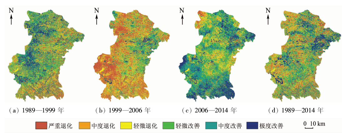
Based on dimidiate pixel model and using Landsat TM/OLI remote sensing images of 4 periods in 25 years (1989—2014) and geological hazards investigation data, the authors analyzed the characteristics of vegetation spatial-temporal pattern in Yanchi County by GIS and discussed the relationship between vegetation coverage and geological hazards. The results showed that the vegetation coverage of study area took on the features of relatively high vegetation coverage in the east and relatively low vegetation coverage in the west. The average vegetation coverage was on the low side generally and presented the characteristics of increase-decrease-increase; correspondingly the vegetation appeared the repetitive process of restoration-degeneration-restoration but had a tendency of recovery as a whole, with restoration distributed in the southeast and northwest and degeneration in the mid-west. Geological hazards point density was high in the south and low in the north, which suggests that the hazards points were concentrated in the south and dispersed in the north. A negative correlation between vegetation coverage and density of geological hazards points was discovered, which suggests the regularity of density of geological hazards points descending with the increasing of vegetation coverage: the higher the vegetation, the lower the density of geological hazards points.
Nandi A, Shakoor A . A GIS-based landslide susceptibility evaluation using bivariate and multivariate statistical analyses[J]. Engineering Geology, 2010,110(1/2):11-20.
doi: 10.1016/j.enggeo.2009.10.001
Jia G Y, Quan Y Q, Li Z H , et al. Geo-hazards assessment for the Gansu segment in Bailongjiang River Basin by using combination weighting method[J]. Journal of Glaciology and Geocryology, 2014,36(5):1227-1236.
Du J, Yang Q H, Yan J , et al. Hazard evaluation of secondary geological disaster based on GIS and information value method[J]. Earth Science, 2010,35(2):324-330.
Xu C, Dai F C, Yao X , et al. GIS platform and certainty factor analysis method based Wenchuan earthquake-induced landslide susceptibility evaluation[J]. Journal of Engineering Geology, 2010,18(1):15-26.
Ni Z Y, He Z W, Zhao Y B , et al. Study on the relationship between vegetation cover and geo-hazards in Danba County based on RS and GIS[J]. Computing Techniques for Geophysical and Geochemical Exploration, 2011,33(2):217-221.
Zeng L K, Xu M, Fang Q , et al. Vegetation and development of geological hazards[J]. Journal of Geological Hazards and Environment Preservation, 2010,21(3):97-100.
Zhang X D, Liu X N, Zhao Z P , et al. The application of RS technique for investigation of geological hazards in Zhongning County of Ningxia[J]. The Chinese Journal of Geological Hazard and Control, 2015,26(3):120-126.
Zhang G P, Xu J, Bi B G . Relations of landslide and debris flow hazards to environmental factors[J]. Chinese Journal of Applied Ecology, 2009,20(3):653-658.
Li K, Sun Y D, Jiang B H , et al. Analysis on spatial-temporal patterns of the vegetation coverage and landslides in Bailongjiang River Basin based on the dimidiate pixel model[J]. Journal of Lanzhou University(Natural Sciences), 2014,50(3):376-382.
[10]
Leprieur C, Verstraete M M, Pinty B . Evaluation of the performance of various vegetation indices to retrieve vegetation cover from AVHRR data[J]. Remote Sensing Reviews, 1994,10(4):265-284.
doi: 10.1080/02757259409532250
[11]
Gutman G, Ignatov A . The derivation of the green vegetation fraction from NOAA/AVHRR data for use in numerical weather prediction models[J]. International Journal of Remote Sensing, 1998,19(8):1533-1543.
doi: 10.1080/014311698215333
[12]
Mu S J, Yang H F, Li J L , et al. Spatio-temporal dynamics of vegetation coverage and its relationship with climate factors in Inner Mongolia,China[J]. Journal of Geographical Sciences, 2013,23(2):231-246.
doi: 10.1007/s11442-013-1006-x
[13]
Gillies R R, Kustas W P, Humes K S . A verification of the “triangle” method for obtaining surface soil water content and energy fluxes from remote measurements of the normalized difference vegetation index(NDVI) and surface[J]. International Journal of Remote Sensing, 1997,18(15):3145-3166.
doi: 10.1080/014311697217026
Jia B Q . Driving factor analysis on the vegetation changes derived from the Landsat TM images in Beijing[J]. Acta Ecologica Sinica, 2013,33(5):1654-1666.
Pang J L, Zhang K B, Qiao N , et al. RS-based study on dynamics of the vegetation coverage in recent 10 years in Yanchi County[J]. Research of Soil and Water Conservation, 2012,19(4):112-115,121.
 2018, Vol. 30
  ), 刘湘南1(