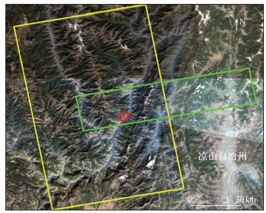
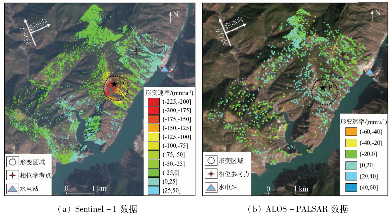
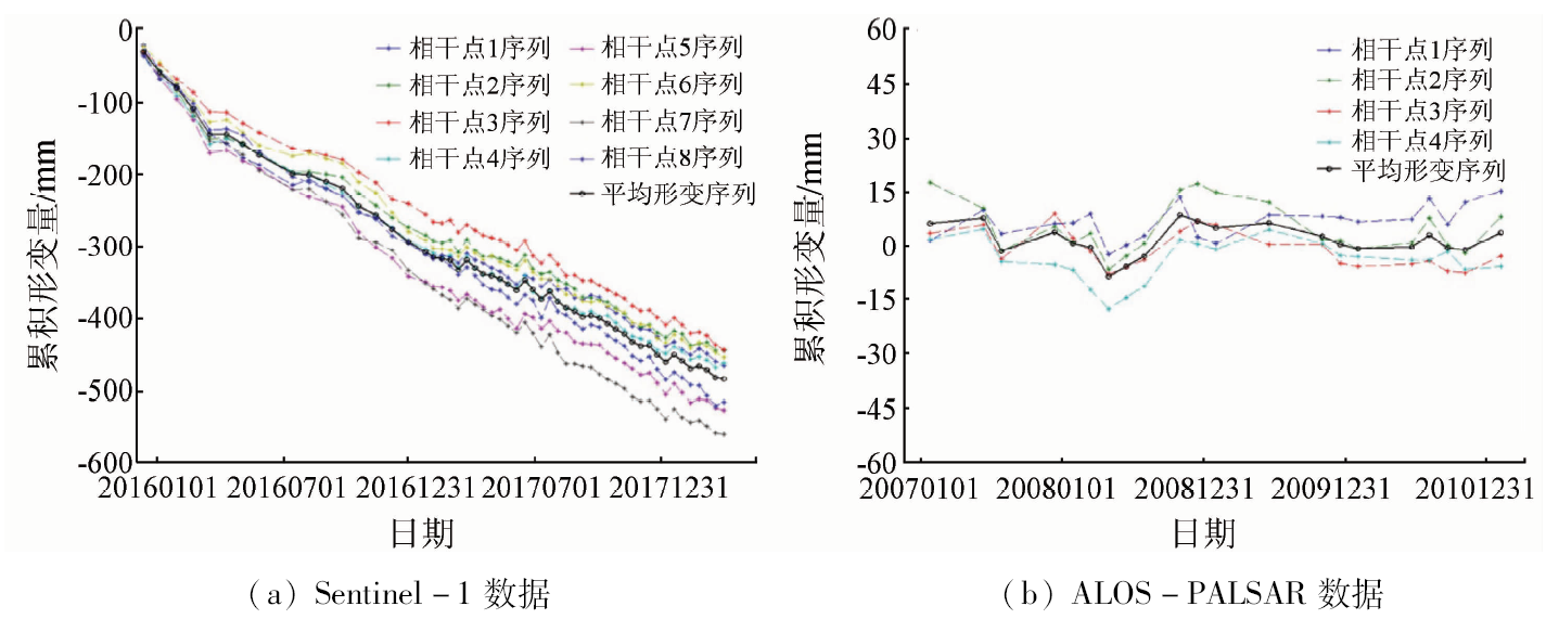
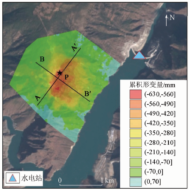
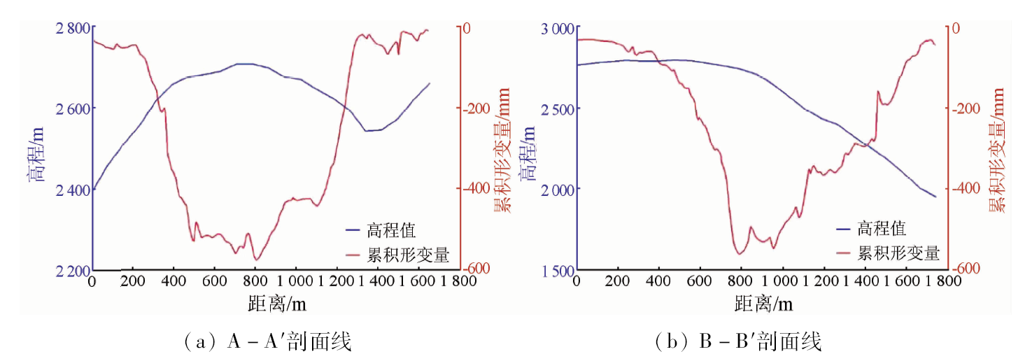
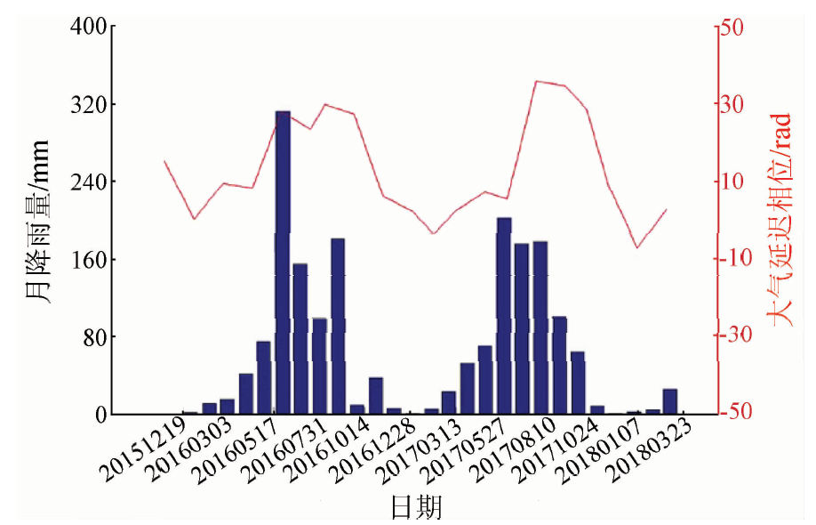
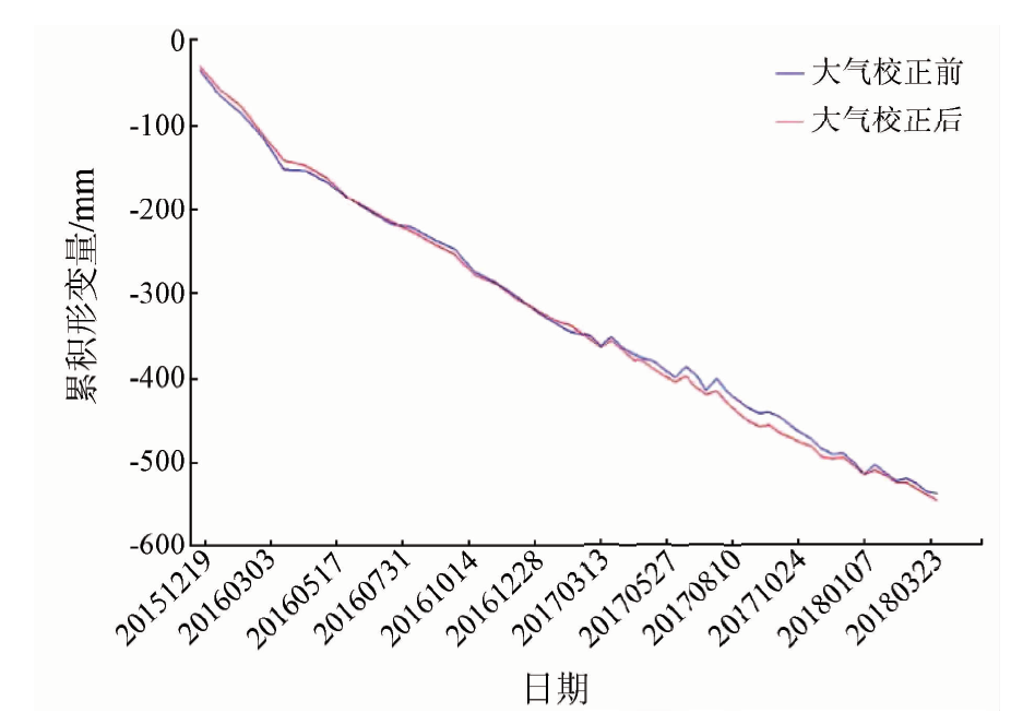
tability monitoring of bank slopes along the reservoirs of hydropower projects is a fundamental task for the safety of dam operation. And deformation detection is a major approach for stability monitoring. Spaceborne InSAR technique has been recognized as an effective tool for deformation detection with its high observation accuracy and capability to work independent of weather and solar illumination. The deformation information of left bank slope of Jinping hydropower station in the Yalong River Basin was obtained by processing 56 images of C-band Sentinel-1 data with small baselines time series InSAR technique. The result indicated that there was a large landslide on the left bank slope about 1.5 km away from the dam upstream of the Jinping I hydropower station, with a surface area of more than 750,000 square meters. The maximum deformation rate in the line of sight exceeded 200 mm/a from 2015 to 2018. The deformation area was mainly concentrated in the middle and upper part of the bank slope. And the maximum cumulative deformation of the line of sight in the observation period was more than 500 mm. The time series of deformation was basically a linear sliding trend without obvious periodicity. The same method was used to process 22 archived images of L-band ALOS-PALSAR data from 2006 to 2011. The results show that the left bank slope was stable before the reservoir impoundment. It is therefore inferred that the sharp rise of water level of the reservoir might be a main trigger factor for this landslide activation.
王振林, 廖明生, 张路, 罗恒, 董杰. 基于时序Sentinel-1数据的锦屏水电站左岸边坡形变探测与特征分析[J]. 国土资源遥感, 2019, 31(2): 204-209.
Zhenlin WANG, Mingsheng LIAO, Lu ZHANG, Heng LUO, Jie DONG. Detecting and characterizing deformations of the left bank slope near the Jinping hydropower station with time series Sentinel-1 data. Remote Sensing for Land & Resources, 2019, 31(2): 204-209.
Li Y, Meng H, Dong Y , et al. Main types and characteristics of geo-hazard in China:Based on the results of geo-hazard survey in 290 counties[J]. The Chinese Journal of Geological Hazard and Control, 2004,15(2):29-34.
Liao M S, Zhang L, Shi X G , et al. Methods and Practice of Radar Remote Sensing Monitoring of Landslide Deformation[M]. Beijing: Science Press, 2017: 2-4.
[3]
李自立 . 滑坡变形监测反演参数及稳定性研究[D]. 西安:长安大学, 2005.
Li Z L . Study on Parameters Inversion and Stability of Landslide Deformation Monitoring[D]. Xi’an:Chang’an University, 2015.
Liao M S, Tang J, Wang T , et al. Landslide monitoring with high-resolution SAR data in the Three Gorges Region[J]. Science China Earth Science, 2012,42(2):217-229.
[6]
Xia Y, Kaufmann H, Guo X F . Landslide monitoring in the Three Gorges Area using D-InSAR and corner reflectors[J]. Photogrammetric Engineering and Remote Sensing, 2004,70(10):1167-1172.
doi: 10.14358/PERS.70.10.1167
[7]
Ferretti A, Prati C, Rocca F . Permanent scatterers in SAR interfero-metry[J]. IEEE Transactions on Geoscience and Remote Sensing, 2001,39(1):8-20.
doi: 10.1109/36.898661
[8]
Berardino P, Fornaro G, Lanarir R , et al. A new algorithm for surface deformation monitoring based on small baseline differential SAR interferograms[J]. IEEE Transactions on Geoscience and Remote Sensing, 2002,40(11):2375-2383.
doi: 10.1109/TGRS.2002.803792
Qin X Q, Liao M S, Yang M S , et al. Monitoring Shanghai relocation housing skew deformation using high resolution PS-InSAR technology[J].Bulletin of Surveying and Mapping, 2016(6):18-21.
Zhou H Y, Wang Y J, Yan S Y , et al. Land subsidence monitoring and analyzing of Cangzhou Area Sentinel-1A/B based time series InSAR[J].Bulletin of Surveying and Mapping, 2017(7):89-93.
[11]
刘广全 . 基于SBAS-InSAR的丹巴县滑坡探测与监测[D]. 西安:长安大学, 2015.
Liu G Q . Landslide Detection and Monitoring of Danba County Based on SBAS-InSAR[D]. Xi’an:Chang’an University, 2015.
[12]
Hooper A, Zebker H, Segall P , et al. A new method for measuring deformation on volcanoes and other natural terrains using InSAR persistent scatterers[J]. Geophysical Research Letters, 2004,31(23):1-5.
Zhao M, Long F, Gong Y . The seismic velocity ratio changes before and after the reservoir filling of Jinping hydropower station[J].Earthquake Research in Sichuan, 2016(2):22-26.
Zhang D X . The Stability Analysis and Destruction of Forecasting Study on Left High Slope of Jinping Hydropower Station Dam[D]. Chengdu:Chengdu University of Technology, 2008.
[15]
Rodriguez E, Morris C S, Belz J E . A global assessment of the SRTM performance[J]. Photogrammetric Engineering and Remote Sensing, 2006,72(3):249-260.
doi: 10.14358/PERS.72.3.249
Gao L T, Yi X W, Li X , et al. Case study of relationship between typical landslide distortion and water changes in Three Gorges Area[J]. Geological Science and Technology Information, 2011,30(4):132-136.
[17]
Yu C, Li Z, Penna N T . Interferometric synthetic aperture Radar atmospheric correction using a GPS-based iterative tropospheric decomposition model[J]. Remote Sensing of Environment, 2018,204:109-121.
doi: 10.1016/j.rse.2017.10.038
Yang Q, Pan Y W, Cheng L , et al. Mechanism of valley deformation of high arch dam and effective stress principle for unsaturated fractured rock mass[J]. Chinese Journal of Rock Mechanics and Engineering, 2015,34(11):2258-2269.
 2019, Vol. 31