1.National Key Laboratory of Remote Sensing Information and Imagery Analyzing Technology, Beijing Research Institute of Uranium Geology, Beijing 100029, China 2.Faculty of Geosciences and Resources, China University of Geosciences (Beijing), Beijing 100083, China
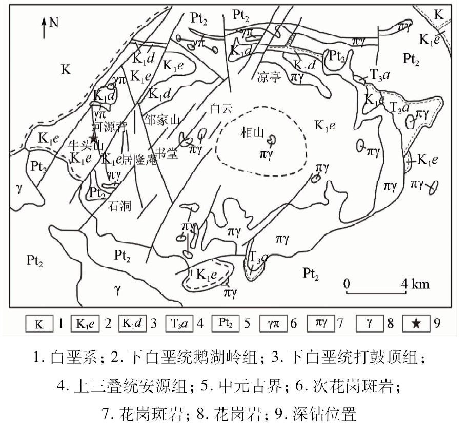
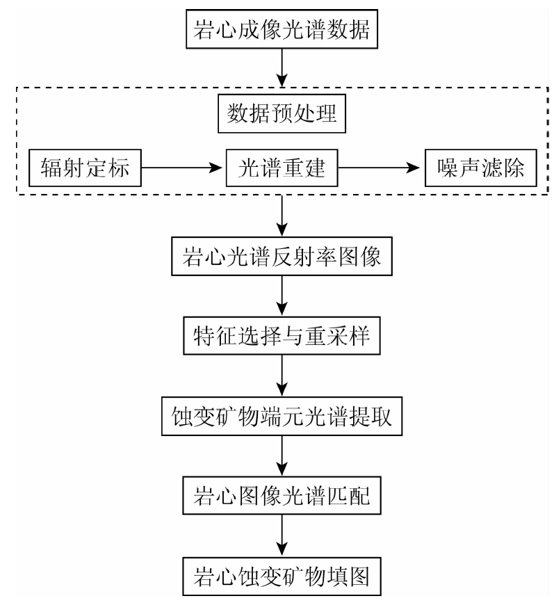
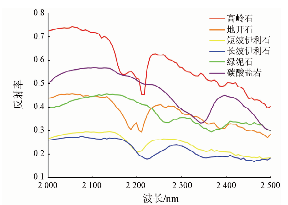
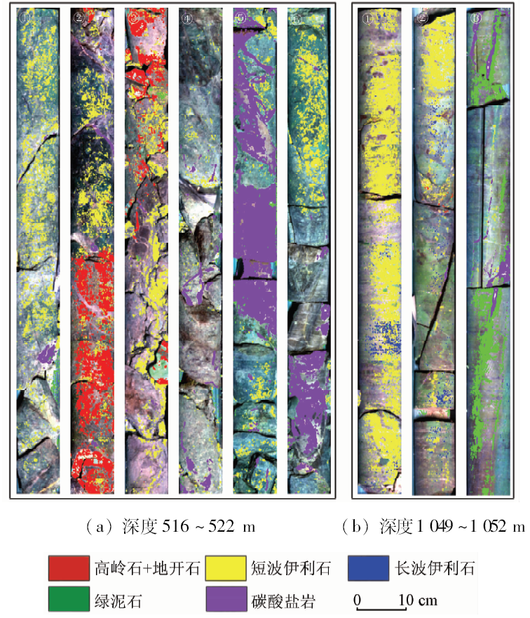
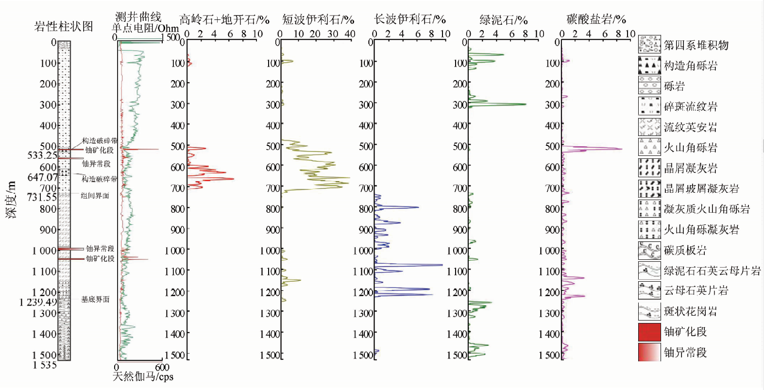
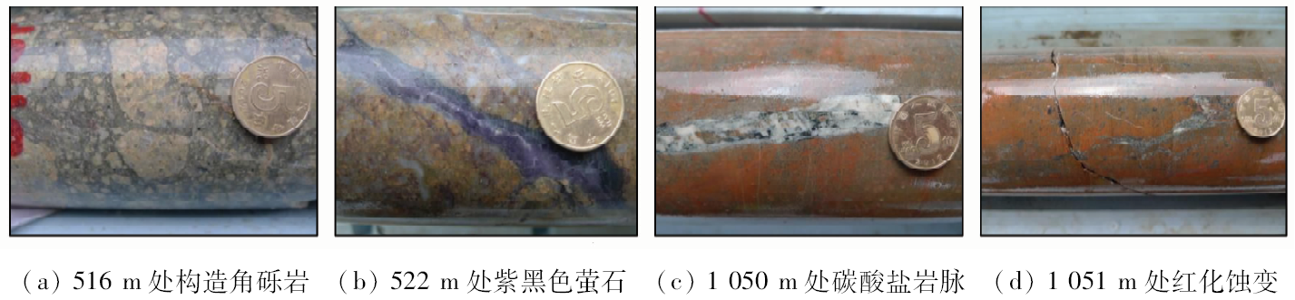
The west of Xiangshan basin is an important potential area in the search for deep-buried uranium ore deposits in Xiangshan uranium orefield, and its deep alteration zoning remains to be further explored. Imaging hyperspectral core scanning technique provides a new means for revealing deep alteration information. On the basis of the imaging hyperspectral scanning data of deep drilling cores in the Niutoushan area of western Xiangshan, mapping of 5 types of altered minerals was realized by data processing. Then, pixels statistic algorithm was used to obtain the relative content logging curve of each altered mineral. The reliability of the imaging hyperspectral logging was verified by comparing the geological lithology and geophysical logging curves. According to the results of imaging hyperspectral logging of deep drill holes, the formations overlying the basement can be divided into three alteration zones. The main alteration of the first is chloritization, which is located in the upper part, and the second main alterations located in the middle part contain kaolinization, dickitization, and illitization dominated by shortwave illite, and the third main alteration is illitization that is characterized by more long wave and less short wave illite, located in the lower part. Uranium mineralizations in the upper and lower parts of the borehole have distinct features of altered mineral combinations and show that formation environments of illites with different wavelength characteristics are relatively different. The short wave illite tends to form in relatively acidic fluid environment, closely related to uranium mineralization controlled by acid alterations; the long wave illite tends to form in relatively alkaline fluid environment and is not closely related to uranium mineralization. Alteration zoning features of deep drill holes reveal that acidic fluid activity is later than alkaline fluid activity and acts on the latter. Uranium is gradually enriched with deuteric potassium metasomatism and acidic fluid activity. The action of deep fluid on the whole has the evolution characteristics of starting from sodium metasomatism to potassium metasomatism, followed by acid metasomatism with the time.
张川, 叶发旺, 徐清俊, 邱骏挺. 相山铀矿田西部深钻岩心成像光谱编录及蚀变分带特征[J]. 国土资源遥感, 2019, 31(2): 231-239.
Chuan ZHANG, Fawang YE, Qingjun XU, Junting QIU. Deep drill logging and its alteration zoning features based on hyperspectral core imaging in west of Xiangshan uranium orefield. Remote Sensing for Land & Resources, 2019, 31(2): 231-239.
Li Z Z, Yang R H, Dang F X , et al. The hyperspectral remote sensing technology and its application[J]. Geological Bulletin of China, 2009,28(2-3):270-277.
Wang R S, Gan F P, Yan B K , et al. Hyperspectral mineral mapping and its application[J]. Remote Sensing for Land and Resources, 2010,22(1):1-13.doi: 10.6046/gtzyyg.2010.01.01.
Wang R S, Xiong S Q, Nie H F , et al. Remote sensing technology and its application in geological exploration[J]. Acta Geologica Sinica, 2011,85(11):1699-1743.
[4]
Bedini E . Mineral mapping in the Kap Simpson complex,central East Greenland,using HyMap and ASTER remote sensing data[J]. Advances in Space Research, 2011,47(1):60-73.
doi: 10.1016/j.asr.2010.08.021
[5]
Molan Y E, Refahi D, Tarashti A H . Mineral mapping in the Maherabad Area,eastern Iran,using the HyMap remote sensing data[J]. International Journal of Applied Earth Observation and Geoinformation, 2014,27:117-127.
doi: 10.1016/j.jag.2013.09.014
[6]
Kruse F A . Identification and mapping of minerals in drill core using hyperspectral image analysis of infrared reflectance spectra[J]. International Journal of Remote Sensing, 1996,17(9):1623-1632.
doi: 10.1080/01431169608948728
[7]
Taylor G R . Mineral and lithology mapping of drill core pulps using visible and infrared spectrometry[J]. Natural Resources Research, 2000,9(4):257-268.
doi: 10.1023/A:1011501125239
Wang J N, Li Z Z, Zhang L F , et al. “Spectral Crust” project:Research on new mineral exploration technology[J]. Journal of Geo-information Science, 2012,14(3):344-351.
[9]
Huntington J, Quigley M, Yang K, et al. A geological overview of HyLogging 18 000 m of core from the Eastern Goldfields of Western Australia [C]//Proceedings 6th International Mining Geology Conference,Darwin:AusIMM, 2006.
[10]
Tappert M, Rivard B, Giles D , et al. Automated drill core logging using visible and near-infrared reflectance spectroscopy:A case study from the Olympic Dam IOCG deposit,South Australia[J]. Economic Geology, 2011,106(2):289-296.
doi: 10.2113/econgeo.106.2.289
[11]
Tappert M C, Rivard B, Giles D , et al. The mineral chemistry,near-infrared,and mid-infrared reflectance spectroscopy of phengite from the Olympic Dam IOCG deposit,South Australia[J]. Ore Geo-logy Reviews, 2013,53(3):26-38.
doi: 10.1016/j.oregeorev.2012.12.006
[12]
Travers S J , Wilson C J L .Reflectance spectroscopy and alteration assemblages at the Leven Star gold deposit,Victoria,Australia[J]. Australian Journal of Earth Sciences, 2015,62(7):873-882.
doi: 10.1080/08120099.2015.1114525
[13]
Shi X Z, Aspandiar M, Oldmeadow D . Reflectance spectral characterization and mineralogy of acid sulphate soil in subsurface using hyperspectral data[J]. International Journal of Sediment Research, 2014,29(2):149-158.
doi: 10.1016/S1001-6279(14)60031-7
[14]
Hill A J, Mauger A J . HyLogging unconventional petroleum core from the Cooper Basin,South Australia[J]. Australian Journal of Earth Sciences, 2016,63(8):1087-1097.
doi: 10.1080/08120099.2016.1261369
Xu Y H, Tian Q J . A drill core spectral logging study in a magnetite-quartzite type iron deposit[J]. Remote Sensing for Land and Resources, 2005,17(3):70-73.doi: 10.6046/gtzyyg.2005.03.17.
Xiu L C, Zheng Z Z, Yu Z K , et al. Study on method of measuring altered minerals in rocks with near-infrared spectrometer[J]. Rock and Mineral Analysis, 2009,28(6):519-523.
Li J, Qi J P, Xiu L C , et al. Application of core spectrum scanner in Zijinshan mineral exploration[J]. Acta Mineralogica Sinica, 2013,33(s2):1020-1021.
Zhang J L, Huang Y J, Wang J H , et al. Hyperspectral drilling core logging and 3D mineral mapping technology for uranium exploration[J]. Uranium Geology, 2013,29(4):249-255.
[20]
Xiu L C, Chen C X, Zheng Z Z , et al. Design and application of core mineral spectrometer[J]. Chinese Optics Letters, 2014,12(8):88-92.
Gan F P, Wang R S, Ma A N . Spectral identification tree(SIT) for mineral extraction based on spectral characteristics of minerals[J]. Earth Science Frontiers, 2003,10(2):445-454.
[24]
Boardman J W, Kruse F A, Green R O. Mapping target signatures via partial unmixing of AVIRIS data:In Summaries [C]//Fifth JPL Airborne Earth Science Workshop.Pasadena:JPL, 1995: 23-26.
[25]
Winter M E. A proof of the N-FINDR algorithm for the automated detection of endmembers in a hyperspectral image [C]//Proceedings of SPIE,Algorithms and Technologies for Multispectral,Hyperspectral,and Ultraspectral Imagery X, 2004,5425:31-41.
[26]
Scott K M, Yang K . Exploration and Mining Report 439R Spectral Reflectance Studies of White Micas[R]. Melbourne:Australian Mineral Industries Research Association, 1997, 1-35.
[27]
Yang K, Huntington J F, Boardman J W , et al. Mapping hydrothermal alteration in the Comstock mining district,Nevada,using simulated satellite-borne hyperspectral data[J]. Australian Journal of Earth Sciences, 1999,46(6):915-922.
doi: 10.1046/j.1440-0952.1999.00754.x
Xiu L C, Zheng Z Z, Yu Z K , et al. Mineral analysis technology application with near infrared spectroscopy in identifying alteration mineral[J]. Acta Geologica Sinica, 2007,81(11):1584-1590.
[29]
Yang K , Browne P R L,Huntington J F ,et al.Characterising the hydrothermal alteration of the Broadlands-Ohaaki geothermal system,New Zealand,using short-wave infrared spectroscopy[J]. Journal of Volcanology and Geothermal Research, 2001,106(1):53-65.
doi: 10.1016/S0377-0273(00)00264-X
Yang Z M, Hou Z Q, Yang Z S , et al. Application of short wavelength infrared (SWIR) technique in exploration of poorly eroded porphyry Cu district:A case study of Niancun ore district,Tibet[J]. Mineral Deposits, 2012,31(4):699-717.
[31]
Zhang X Y, Li P J . Lithological mapping from hyperspectral data by improved use of spectral angle mapper[J]. International Journal of Applied Earth Observation and Geoinformation, 2014,31(5):95-109.
doi: 10.1016/j.jag.2014.03.007
Zhang C, Ye F W, Yao J L , et al. Implementation method of drill core logging based on imaging spectrometer[J]. Remote Sensing Information, 2017,32(5):69-74.
Guo N, Huang Y R, Zheng L , et al. Alteration zoning and prospecting model of epithermal deposit revealed by shortwave infrared technique:A case study of Tiegelongnan and Sinongduo Deposits[J]. Acta Geoscientia Sinica, 2017,38(5):767-778.
[34]
Harraden C L, Mcnulty B A, Gregory M J , et al. Shortwave infrared spectral analysis of hydrothermal alteration associated with the Pebble Porphyry Copper-Gold-Molybdnum deposit,Iliamna,Alaska[J]. Economic Geology, 2013,108(3):483-494.
doi: 10.2113/econgeo.108.3.483
[35]
Herrmann W, Blake M, Doyle M , et al. Short wavelength infrared (SWIR) spectral analysis of hydrothermal alteration zones associated with base metal sulfide deposits at Rosebery and Western Tharsis,Tasmania,and Highway-Reward,Queensland[J]. Economic Geology, 2001,96(5):939-955.
[36]
Yang K, Lian C, Huntington J F , et al. Infrared spectral reflectance characterization of the hydrothermal alteration at the Tuwu Cu-Au deposit,Xinjiang,China[J]. Mineralium Deposita, 2005,40(3):324-336.
doi: 10.1007/s00126-005-0479-7
Lin J R, Hu Z H, Xie G F , et al. The indicators and direction for deep exploration in Xiangshan uranium ore field[J]. Uranium Geo-logy, 2013,29(6):321-327.
Hu B Q, Wang Q, Qiu L F , et al. Geochemistry of alkali metasomatized rocks of Zoujiashan uranium ore-deposit in Xiangshan ore-field[J]. Geotectonica et Metallogenia, 2016,40(2):377-385.
 2019, Vol. 31