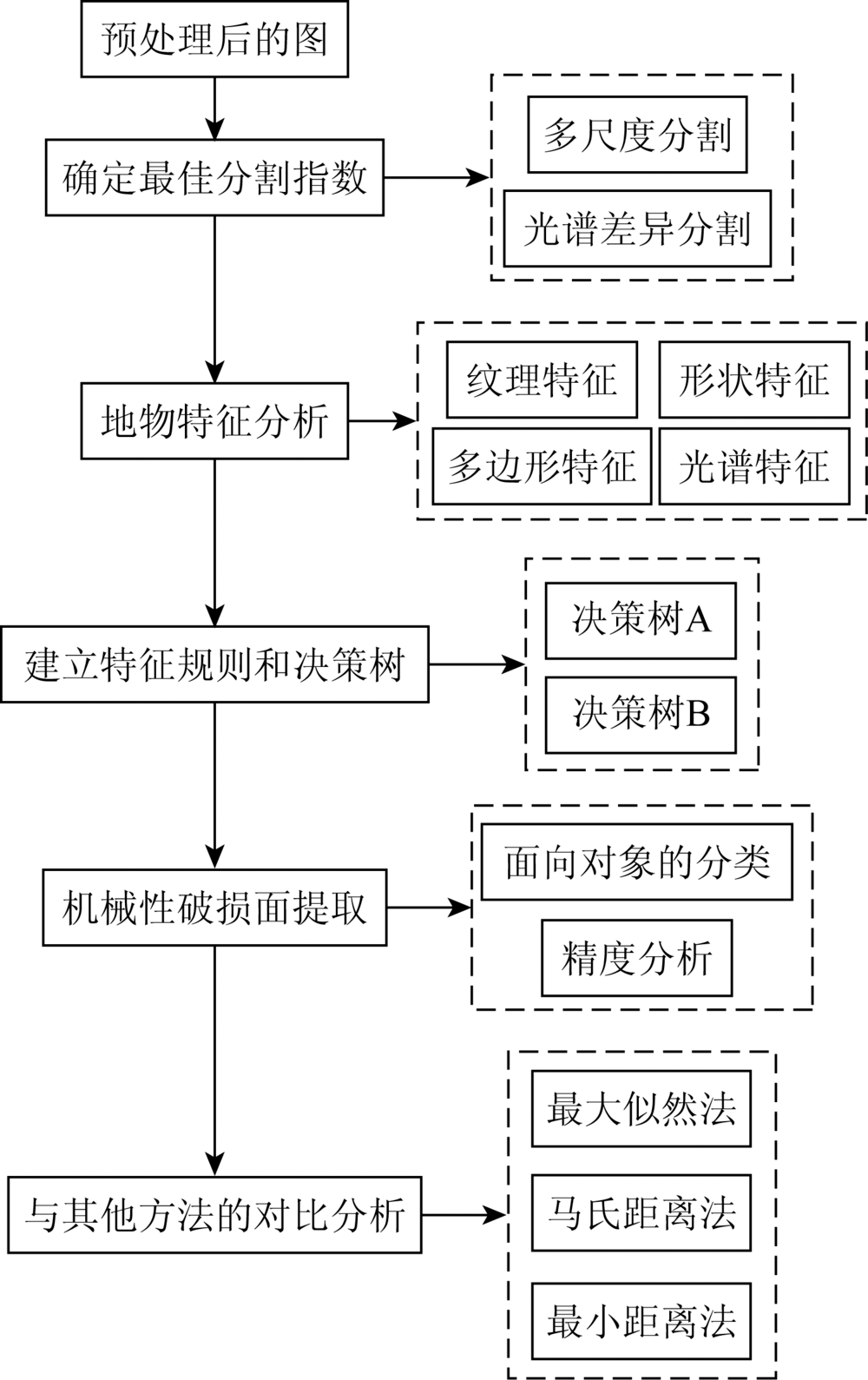
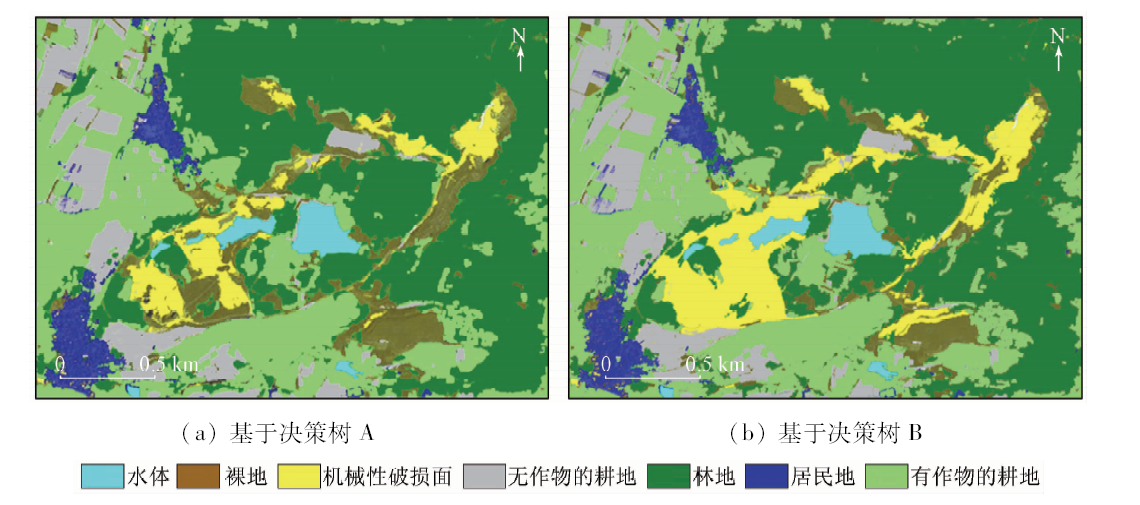
Mechanical damaged surface tends to cause soil erosion, secondary geological hazards and other ecological environment problems, but there is still a lack of effective extraction methods based on remote sensing images. Based on the GF-2 remote sensing image, the authors studied the object-oriented extraction method based on texture features in Tanglangchuan watershed with densely distributed mechanical damage surface. According to the seven types of features, the classification rules were established. On the basis of the optimal scale segmentation, the decision tree A based on spectral features and the decision tree B based on "spectral + texture" features are classified in object-oriented way. Precision evaluation and analysis show that, compared with the traditional supervised classification method and the spectral-based object-oriented classification method, the classification method improves the Kappa coefficient and the total accuracy to 0.82 and 86.25%, respectively, and also effectively improves the extraction accuracy of mechanical damage surface.
(0.2<NDVI<0.7) and (Stddev of length of edges (polygon)<4)
有作物的耕地
(0.2<NDVI<0.7) and (Stddev of length of edges (polygon)≥4)
居民地
(NDVI≥0.7 or NDVI≤0.2) and (length/width<2.8 or length/width>35) and (600<mean NIR<1 500)
无作物的耕地
(meanNIR≥1 500 or meanNIR≤600) and (2.8≤length/width≤35)and (8<Stddev of length of edges (polygon)<52)
裸地
(NDVI≥0.07 and NDVI≤0.01)
机械性破损面
(Stddev of length of edges (polygon)≤8 or Stddev of length of edges (polygon)≥52) and (0.01<NDVI<0.07) and (contrast>1 000) and (Homogeneity<0.07)
Tab.3 地物的分类规则
Fig.5 基于决策树A和决策树B的面向对象分类结果
土地利用 类型
决策树A
决策树B
用户精 度/%
制图精 度/%
用户精 度/%
制图精 度/%
裸地
83.56
83.56
87.33
84.42
机械性破损面
86.43
86.53
89.63
86.83
总体精度/%
78.34
86.25
Kappa系数
0.73
0.82
Tab.4 决策树A和决策树B的机械性破损面提取精度对比
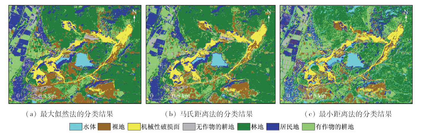
Fig.6 不同监督分类方法的结果对比
精度
基于像元的监督分类
面向对象分类
最小距 离法
马氏距 离法
最大似 然法
基于光谱 的决策树A
基于“光谱+ 纹理”的 决策树B
总体精度/%
70.21
72.67
74.53
78.34
86.25
Kappa系数
0.60
0.62
0.65
0.73
0.82
Tab.5 面向对象分类与监督分类精度对比
[1]
陈佳俊. 基于GF-2卫星影像的川东丘陵地区耕地信息提取[D]. 成都:成都理工大学, 2017.
Chen J J. Extraction of cultivated land information in hilly area of Eastern Sichuan based on GF-2 satellite image[D]. Chengdu:Chengdu University of Technology, 2017.
Wang L, Yang W, Ren J T, et al. Object-oriented typical urban area object extraction method for GF-2 image[J].Surveying and Mapping Bulletin, 2018(1):138-142.
[3]
Ouyang H L, Shen J W, Zhou T G. Application of object-oriented classification method to typhoon disaster information extraction[J]. Journal of Natural Disasters, 2016,25(6):9-17.
[4]
Xu F N, Qi Y, Wang J H, et al. Riparian forest vegetation coverage information classification based on object-oriented method in Heihe River[J]. Remote Sensing Technology and Application, 2015. 30(5):996-1005.
Dai L L, Li H T, Gu H Y, et al. Construction of object-oriented classification rules for remote sensing images based on feature selection[J]. Surveying and Mapping Science, 2019,44(2):26-32.
Jia W, Gao X H, Yang L Y, et al. Object-oriented extraction of surface cover information in complex terrain area[J]. Journal of Lanzhou University:Natural Science Edition, 2018,54(4):486-493.
Zhang J Y, Yao G H, Lin L, et al. Combined with active learning and word bag model,automatic classification of high-score remotesensing image No.2[J]. Surveying and Mapping Bulletin, 2019,20(2):103-107.
Zhu H T, Zhang X, Wang S D, et al. Classification of remote sensing images in semi-arid areas based on object-oriented decision tree algorithm[J]. Remote sensing information, 2013,28(4):50-56.
Zhang H, Zhang G G, Wu R. Object-oriented classification of Minqin Oasis vegetation based on GF-1 satellite data[J]. Arid RegionGeography, 2017,40(4):831-838.
Su T F, Zhang S W, Li H Y. High resolution remote sensing image segmentation algorithm based on texture features and regional growth[J]. Land and Resources Remote Sensing, 2017,29(2):72-81.doi: 10.6046/gtzyyg.2017.02.11.
[11]
张东梅. 基于多尺度分割的土地利用分类研究[D]. 南昌:东华理工大学, 2017, 7-53.
Zhang D M. Land use classification based on multi-scale segmentation[D]. Nanchang:East China University of Technology, 2017, 7-53.
Wang E L, Li C J, Zhou J P, et al. Tree species classification of plantations in Beijing plain based on multi-temporal remote sensing images[J]. Journal of Beijing University of Technology, 2017,43(5):710-718.
[13]
Moya L, Zakeri H, Yamazaki F, et al. 3D gray level co-occurrence matrix and its application to identifying collapsed buildings[J].Journal of Photogrammetry and Remote Sensing, 2019(149):14-28.
[14]
Huang X, Liu X B, Zhang L P. A Multichannel gray level co-occurrence matrix for multi/hyperspectral image texture representation[J]. Remote Sensing. 2014,6(9):8424-8445.
 2020, Vol. 32