Please wait a minute...
 
国土资源遥感  2021, Vol. 33 Issue (1): 123-128    DOI: 10.6046/gtzyyg.2020143
     技术方法 本期目录 | 过刊浏览 | 高级检索 |
一种基于格网索引优化的遥感影像自动配准算法
张萌生1,2,3(), 杨树文1,2,3(), 贾鑫1,2,3, 臧丽日1,2,3
1.兰州交通大学测绘与地理信息学院,兰州 730070
2.地理国情监测技术应用国家地方联合工程研究中心,兰州 730070
3.甘肃省地理国情监测工程实验室,兰州 730070
An automatic registration algorithm for remote sensing images based on grid index
ZHANG Mengsheng1,2,3(), YANG Shuwen1,2,3(), JIA Xin1,2,3, ZANG Liri1,2,3
1. Faculty of Geomatics, Lanzhou Jiaotong University, Lanzhou 730070, China
2. National-Local Joint Engineering Research Center of Technologies and Applications for National Geographic State Monitoring, Lanzhou 730070, China
3. Gansun Provincial Engineering Laboratory for National Geographic State Monitoring, Lanzhou 730070, China
全文: PDF(5719 KB)   HTML  
输出: BibTeX | EndNote (RIS)      
摘要 

针对SIFT算法在遥感影像配准过程中捕获配准点对数量较少和误匹配较多等问题,提出了一种基于格网索引的遥感影像自动配准的算法。首先,采用SIFT算法提取特征点和特征向量,并通过欧氏距离进行匹配; 其次,建立格网索引剔除部分误匹配点对,从而提高了随机抽样一致算法的精度; 最后,使用多项式几何纠正算法实现遥感影像的精确配准。实验结果表明: 该算法比传统分块算法在遥感影像中得到的匹配点对精度更高,并且考虑到不同遥感影像配准场景的差异。

服务
把本文推荐给朋友
加入引用管理器
E-mail Alert
RSS
作者相关文章
张萌生
杨树文
贾鑫
臧丽日
关键词 SIFT格网索引随机抽样一致影像配准    
Abstract

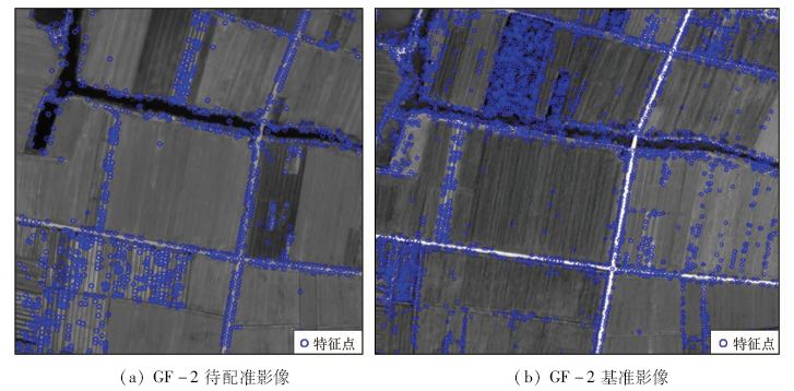
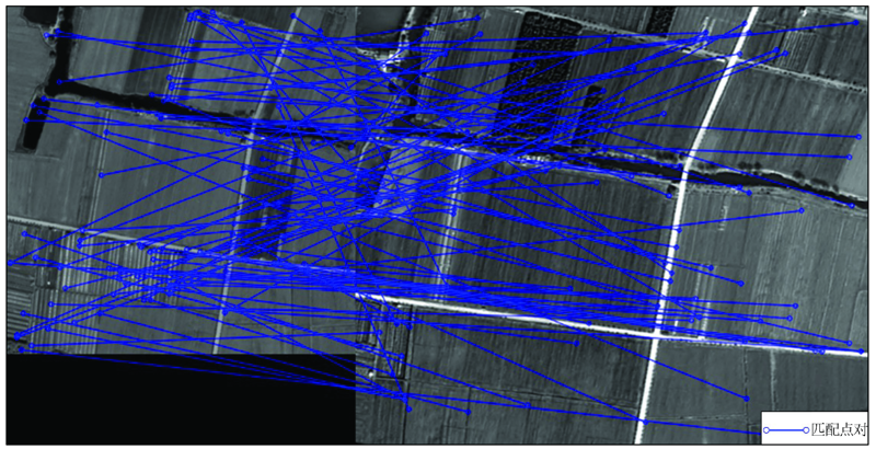
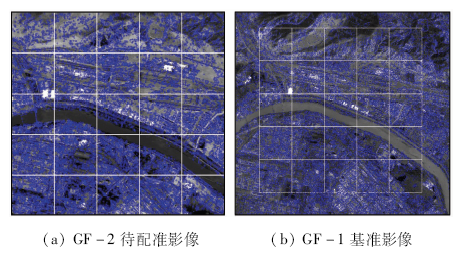
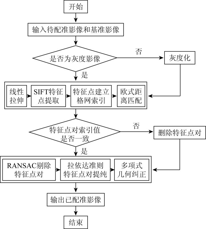
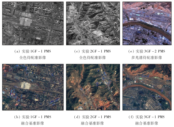
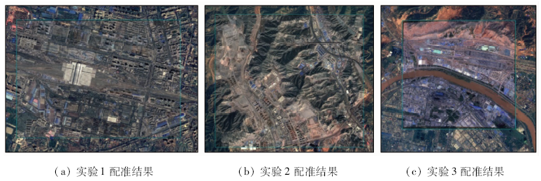
This paper proposes an algorithm for automatic registration of remote sensing images based on grid index, aiming at tackling the problems of a small number of registration point pairs and a large number of mismatches captured by the SIFT algorithm in the process of remote sensing image registration. First, SIFT algorithm is used to extract feature points and feature vectors, and matching is made by Euclidean distance; secondly, a grid index is established to eliminate part of the mismatched point pairs, thereby improving the accuracy of the random sampling consensus algorithm; finally, geometric polynomials are used to achieve accurate registration of remote sensing images. The experimental results show that the algorithm has higher accuracy of matching point pairs than the traditional block algorithm in remote sensing images, and takes into account the differences in registration scenes of different remote sensing images.

Key wordsSIFT    grid index    RANSAC    image registration
收稿日期: 2021-05-14      出版日期: 2021-03-18
ZTFLH:  P237  
基金资助:国家重点研发计划地球观测与导航“星空地遥感立体监测技术”(2017YFB0504201);国家自然科学基金项目“基于高分辨率卫星影像的彩钢板建筑与城市空间结构演变关系研究”共同资助(41761082)
通讯作者: 杨树文
作者简介: 张萌生(1994-),男,硕士研究生,主要从事影像处理的研究。Email: 642722474@qq.com
引用本文:   
张萌生, 杨树文, 贾鑫, 臧丽日. 一种基于格网索引优化的遥感影像自动配准算法[J]. 国土资源遥感, 2021, 33(1): 123-128.
ZHANG Mengsheng, YANG Shuwen, JIA Xin, ZANG Liri. An automatic registration algorithm for remote sensing images based on grid index. Remote Sensing for Land & Resources, 2021, 33(1): 123-128.
链接本文:  
https://www.gtzyyg.com/CN/10.6046/gtzyyg.2020143      或      https://www.gtzyyg.com/CN/Y2021/V33/I1/123
Fig.1  SIFT提取的特征点
Fig.2  SIFT算法进行匹配后的结果(随机显示100对)
Fig.3  遥感影像提取特征点后建立格网索引
Fig.4  基于格网索引优化的遥感影像配准流程
编号 待配准影像 基准影像 影像特点
卫星传感器 空间分
辨率/m
大小/像素 卫星传感器 空间分
辨率/m
大小/像素
1 GF-1 PMS全色 2 1 213×866 GF-1 PMS融合 2 1 640×1 247 地形平坦
2 GF-1 PMS全色 2 1 854×1 660 GF-1 PMS融合 2 2 437×2 103 地形起伏较大
3 GF-2 PMS多光谱 4 1 077×1 025 GF-1 PMS融合 2 2 916×2 755 分辨率差异大、拍摄卫星不同
Tab.1  实验数据的详细信息
Fig.5  实验数据
编号 SIFT SIFT+RANSAC 分块SIFT 本文算法
数量/个 正确率/% 数量/个 正确率/% 数量/个 正确率/% 数量/个 正确率/%
1 302 66.23 242 82.64 1 234 65.64 824 98.30
2 543 73.66 445 89.89 2 337 60.98 1 457 97.80
3 117 42.74 71 70.42 378 34.92 141 93.62
Tab.2  4种算法配准点对数量和正确率对比
Fig.6  影像配准结果
点号 配准结果 参考影像 误差
X坐标 Y坐标 X坐标 Y坐标
1 388 878.864 2 3 991 408.902 2 388 877.898 1 3 991 409.868 6 1.867 278 171
2 387 901.443 2 3 991 468.957 5 387 902.409 5 3 991 469.440 7 1.167 217 930
3 387 173.594 8 3 991 709.204 0 387 172.990 8 3 991 710.411 9 1.823 838 411
4 386 640.921 4 3 991 768.720 2 386 639.471 9 3 991 768.237 0 2.334 532 490
5 388 840.743 0 3 992 224.246 2 388 842.675 8 3 992 223.279 9 4.669 451 530
6 387 287.925 7 3 992 392.608 9 387 289.375 3 3 992 394.058 5 4.202 680 320
7 386 452.627 8 3 992 431.072 6 386 453.594 1 3 992 432.662 3 3.460 881 780
8 388 841.030 2 3 992 224.250 7 388 841.803 1 3 992 223.477 6 1.195 058 021
9 388 269.212 1 3 992 859.006 4 388 268.796 8 3 992 860.314 0 1.882 291 850
10 387 464.323 5 3 991 903.360 7 387 464.323 5 3 991 905.092 5 2.999 131 239
Tab.3  配准精度评价
[1] 李孚煜, 叶发茂. 基于SIFT的遥感图像配准技术综述[J]. 国土资源遥感, 2016,28(2):14-20.doi: 10.6046/gtzyyg.2016.02.03.
Li F Y, Ye F M. Summarization of SIFT-based remote sensing image registration techniques[J]. Remote Sensing for Land and Resources, 2016,28(2):14-20.doi: 10.6046/gtzyyg.2016.02.03.
[2] Lowe D G. Object recognition from local scale-invariant features[C]// iccv.IEEE Computer Society, 1999.
[3] Lowe D G. Distinctive image features from scale-invariant keypoints[J]. International Journal of Computer Vision, 2004,60(2):91-110.
doi: 10.1023/B:VISI.0000029664.99615.94
[4] Mikolajczyk K, Schmid C. A performance evaluation of local descriptors[J]. IEEE Trans Pattern Analysis and Machine Intelligence, 2005,27(10):1615-1630.
doi: 10.1109/TPAMI.2005.188
[5] 李晓明, 郑链, 胡占义. 基于SIFT特征的遥感影像自动配准[J]. 遥感学报, 2006,10(6):885-892.
pmid: 29938116
Li X M, Zheng L, Hu Z Y. SIFT based automatic registration of remotely-sensed imagery[J]. Journal of Remote Sensing, 2006,10(6):885-892.
doi: 10.3390/rs10060885 pmid: 29938116
[6] Fischler M A, Bolles R C. Random sample consensus:A paradigm for model fitting with applications to image analysis and automated cartography[J]. Communications of the ACM, 1981,24(6):381-395.
doi: 10.1145/358669.358692
[7] 程焱, 周焰, 林洪涛. 基于SIFT特征遥感影像自动配准与拼接[J]. 遥感技术与应用, 2008,23(6):721-728,608.
Cheng Y, Zhou Y, Lin H T. Automatic registration and mosaic of remote sensed imagery based on SIFT feature[J]. Remote Sensing Technology and Application, 2008,23(6):721-728,608.
[8] 李芳芳, 肖本林, 贾永红, 等. SIFT算法优化及其用于遥感影像自动配准[J]. 武汉大学学报(信息科学版), 2009,34(10):1245-1249.
Li F F, Xiao B L, Jia Y H, et al. Improved SIFT algorithm and its application in automatic registration of remotely-sensed imagery[J]. Geomatics and Information Science of Wuhan University, 2009,34(10):1245-1249.
[9] 程红, 陈文剑. 基于SIFT算法的图像匹配剔点方法研究[J]. 地理与地理信息科学, 2012,28(6):17-19,27.
Cheng H, Chen W J. A method to reject points based on SIFT for image matching[J]. Geography and Geo-Information Science, 2012,28(6):17-19,27.
[10] 张谦, 贾永红, 胡忠文. 多源遥感影像配准中的SIFT特征匹配改进[J]. 武汉大学学报(信息科学版), 2013,38(4):455-459.
Zhang Q, Jia Y H, Hu Z W. An improved SIFT algorithm for multi-source remote sensing image registration[J]. Geomatics and Information Science of Wuhan University, 2013,38(4):455-459.
[11] 张谦, 贾永红, 吴晓良, 等. 一种带几何约束的大幅面遥感影像自动快速配准方法[J]. 武汉大学学报(信息科学版), 2014,39(1):17-21,31.
Zhang Q, Jia Y H, Wu X L, et al. A rapid image registration method based on restricted geometry constraints for large-size remote sensing image[J]. Geomatics and Information Science of Wuhan University, 2014,39(1):17-21,31.
[12] 沈宇臻, 李百寿, 李灵芝. 一种基于邻域投票的异源光学影像SIFT匹配误差剔除方法[J]. 测绘通报, 2018(2):55-60,93.
Shen Y Z, Li B S, Li L Z. A method of SIFT matching error elimination for heterogeneous optical images based on neighborhood voting[J]. Bulletin of Surveying and Mapping, 2018(2):55-60,93.
[13] 闫浩文, 王明孝, 王中辉 .计算几何: 空间数据处理算法[M]. 北京: 科学出版社, 2012.
Yan H W, Wang M X, Wang Z H. Computational geometry:Spatial data processing algorithms[M]. Beijing: Science Press, 2012.
[14] 朱志文, 沈占锋, 骆剑承. 改进SIFT点特征的并行遥感影像配准[J]. 遥感学报, 2011,15(5):1024-1039.
Zhu Z W, Shen Z F, Luo J C. Parallel remote sensing image registration based on improved SIFT point feature[J]. Journal of Remote Sensing, 2011,15(5):1024-1039.
[1] 臧丽日, 杨树文, 申顺发, 薛庆, 秦肖伟. 耦合分水岭与形态学的特殊纹理影像配准算法[J]. 自然资源遥感, 2022, 34(1): 76-84.
[2] 薛白, 付钰莹, 崔成玲, 宋艳茹, 赵世湖. 多重约束条件下的不同遥感影像匹配方法[J]. 国土资源遥感, 2020, 32(3): 49-54.
[3] 康晋洁, 戚浩平, 杨清华, 陈华. 道路通行障碍物遥感检测与通过性评价[J]. 国土资源遥感, 2020, 32(2): 94-102.
[4] 叶发茂, 罗威, 苏燕飞, 赵旭青, 肖慧, 闵卫东. 卷积神经网络特征在遥感图像配准中的应用[J]. 国土资源遥感, 2019, 31(2): 32-37.
[5] 杜守基, 邹峥嵘, 张云生, 张明磊. L0级机载三线阵影像连接点自动提取[J]. 国土资源遥感, 2017, 29(1): 65-70.
[6] 李迁, 甘拯, 支晓栋, 刘玥, 王建超, 金鼎坚. 无人机近红外传感器数据匹配方法[J]. 国土资源遥感, 2017, 29(1): 86-91.
[7] 李孚煜, 叶发茂. 基于SIFT的遥感图像配准技术综述[J]. 国土资源遥感, 2016, 28(2): 14-20.
[8] 赵政, 凌霄, 孙长奎, 李勇志. 基于POS的无人机倾斜影像匹配方法[J]. 国土资源遥感, 2016, 28(1): 87-92.
[9] 耿娟, 何成龙, 刘宪鑫. 基于CSIFT特性的无人机影像匹配[J]. 国土资源遥感, 2016, 28(1): 93-100.
[10] 孙彬, 边辉, 王培忠. 基于势函数点分布调整的SIFT图像配准算法[J]. 国土资源遥感, 2015, 27(3): 36-41.
[11] 李政, 李永树, 楚彬, 唐敏. 基于加权整体最小二乘法的无人机影像配准[J]. 国土资源遥感, 2014, 26(2): 69-73.
[12] 李伟峰, 周金强, 方圣辉. 基于改进Hausdorff距离的图像配准方法[J]. 国土资源遥感, 2014, 26(2): 93-98.
[13] 王晓华, 邓喀中, 杨化超. 集成互补不变特征的SAR影像自动配准[J]. 国土资源遥感, 2014, 26(1): 52-56.
Viewed
Full text


Abstract

Cited

  Shared   
  Discussed   
京ICP备05055290号-2
版权所有 © 2015 《自然资源遥感》编辑部
地址:北京学院路31号中国国土资源航空物探遥感中心 邮编:100083
电话:010-62060291/62060292 E-mail:zrzyyg@163.com
本系统由北京玛格泰克科技发展有限公司设计开发