A comparative study of methods for monitoring and assessing urban green space resources at multiple scales
XIONG Yujiu1,2(), ZHAO Shaohua3, YAN Chunhua4, QIU Gouyu4, SUN Hua5,6,7, WANG Yanlin8, QIN Longjun4()
1. School of Civil Engineering, Sun Yat-Sen University, Guangzhou 510275, China 2. Guangdong Engineering Technology Research Center of Water Security Regulation and Control for Southern China, Guangzhou 510275, China 3. Satellite Environment Center, Ministry of Ecology and Environment/State Environmental Protection Key Laboratory of Satellite Remote Sensing, Beijing 100094, China 4. School of Environment and Energy, Peking University Shenzhen Graduate School, Peking University, Shenzhen 518055, China 5. Research Center of Forestry Remote Sensing & Information Engineering, Central South University of Forestry and Technology, Changsha 410004, China 6. Key Laboratory of Forestry Remote Sensing Based Big Data & Ecological Security for Hunan Province, Changsha 410004, China 7. Key Laboratory of State Forestry & Grassland Administration on Forest Resources Management and Monitoring in Southern Area, Changsha 410004, China 8. Guangzhou Municipal Planning and Natural Resources Bureau, Guangzhou 510000, China
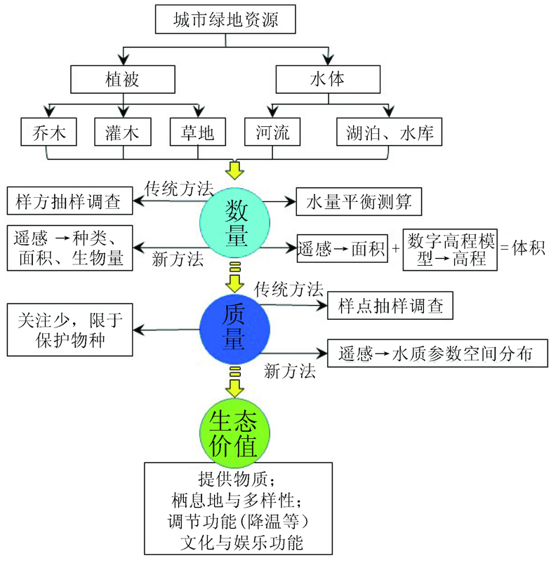
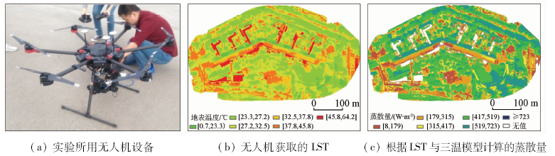
Urban green spaces are important ecological resources in cities; therefore, quantitative assessment of these green space resources as well as establishment of monitoring system at multiple scales is urgently required for assisting natural resources management and eco-city construction. The objectives of this study are to summarize major methods used to assess and monitor two typical urban green space resources, i.e., vegetation and water bodies, in terms of quantity, quality, and ecosystem service value, and to discuss advantage and disadvantage of these methods. Some results have been obtained: ① Although traditional sampling methods can obtain quantitative information for urban vegetation, fragmentation and patch of urban vegetation has limited scaling such information to larger scales; ② Satellite remote sensing (RS), which can provide information such as spatial distribution, area, vegetation classification, and water quality, is an effective method to assess and monitor urban green spaces; nonetheless, detailed information, such as biomass and water volume, requires high spatial resolution (e.g., < 5 m) RS data as well as corresponding methods to process the data; ③ Unmanned aerial vehicle (UAV) can provide land surface information at high spatial resolution (e.g., < 5 cm); however, UAV has limitations, such as limited data coverage and challenged data processing; ④ Lots of studies focus on the relationship between urban green spaces and urban heat islands, but the mechanism, i.e., how much energy is consumed by evapotranspiration and its impact on cooling effect, is less focused, which is likely due to a relatively low spatial resolution of available thermal infrared RS data. In summary, there are still lots of challenges in assessing and monitoring nature resources, including urban green spaces.
熊育久, 赵少华, 鄢春华, 邱国玉, 孙华, 王艳林, 秦龙君. 城市绿地资源多尺度监测与评价方法探讨[J]. 国土资源遥感, 2021, 33(1): 54-62.
XIONG Yujiu, ZHAO Shaohua, YAN Chunhua, QIU Gouyu, SUN Hua, WANG Yanlin, QIN Longjun. A comparative study of methods for monitoring and assessing urban green space resources at multiple scales. Remote Sensing for Land & Resources, 2021, 33(1): 54-62.
United Nations, Department of Economic and Social Affairs, Population Division. World urbanization prospects 2018:Highlights[EB/OL].[2018-11-27]. https://www.un.org/development/desa/pd/content/world-urbanization-prospects-2018-highlights
[2]
Bai X, Shi P, Liu Y. Realizing China’s urban dream[J]. Nature, 2014,509:158-160.
pmid: 24812683
[3]
Coumou D, Robinson A. Historic and future increase in the global land area affected by monthly heat extremes[J]. Environmental Research Letters, 2013,8:034018.
[4]
Sun X, Sun Q, Zhou X, et al. Heat wave impact on mortality in Pudong New Area,China in 2013[J]. Science of the Total Environment, 2014,493:789-794.
Zhang Y L. Urbanization in China and its eco-environmental effects:a review on the discussion of “2018 Chinese humanities and social sciences environment forum”[J]. Journal of Nanjing Tech University (Social Science Edition), 2019,18(1):1-10.
[6]
Haase D, Larondelle N, Andersson E, et al. A quantitative review of urban ecosystem service assessments:Concepts,models,and implementation[J]. AMBIO(43):413-433.
Zhang Y L, Li X. New thought on urban green space system planning based on the perspective of supply side[J]. Journal of Chinese Urban Forestry, 2017,15(1):1-4.
Han Y W, Dai F. Review of study on ecosystem services function of urban green spaces:Indicators,methods and assessment framework[J]. Chinese Landscape Architecture, 2018,34(10):55-60.
Li X, Ma X D, Xue X T, et al. Spatial supply-demand evaluation and layout optimization for urban green space:A case study of Xuzhou central district[J]. Scientia Geographica Sinica, 2019,39(11):1771-1779.
Qiu G Y, Zhang X N. China’s urbanization and its ecological environment challenges in the 21st century[J]. Advances in Earth Science, 2019,34(6):640-649.
Zhao S H, Liu S H, Liu Q Q, et al. Progress of urban ecological environment monitoring by remote sensing in China[J]. Ecology and Environmental Sciences, 2019,28(6):1261-1271.
Ye Y Z, Zhang C M, Deng Y, et al. Research on the current situation and problems of natural resources monitoring and natural resources assets monitoring in China[J]. Bulletin of Surveying and Mapping, 2019(10):23-29.
[13]
Grimm N B, Faeth S H, Golubiewski N E, et al. Global change and the ecology of cities[J]. Science, 2008(319):756-760.
Zhao J J, Ouyang Z Y, Zheng H, et al. Proposed procedure in designing and planning stratified random selection investigation of urban vegetation[J]. Chinese Journal of Ecology, 2009,28(7):1430-1436.
[15]
Yin J, Yang J. Effects of sampling approaches on quantifying urban forest structure[J]. Landscape and Urban Planning, 2020(195):103722.
Wang F, Zhuo L, Li X, et al. Urban vegetation stress level monitoring based on hyperspectral feature selection and RBF neural network[J]. Scientia Geographica Sinica, 2008(1):77-82.
Pan Z K, Wang F, Xia L H, et al. Research on urban vegetation stress monitoring by hyperspectral remote sensing[J]. Remote Sensing Technology and Application, 2012,27(1):68-76.
[18]
Scott C T. Sampling methods for estimating change in forest resources[J]. Ecological Applications, 1998,8:228-233.
Liang S L, Bai R, Chen X N, et al. Review of China’s land surface quantitative remote sensing development in 2019[J]. Journal of Remote Sensing, 2020,24(6):618-671.
[22]
Pause M, Schweitzer C, Rosenthal M, et al. In situ/remote sensing integration to assess forest health:A review[J]. Remote Sensing, 2016(8):471.
[23]
Wulder M. Optical remote-sensing techniques for the assessment of forest inventory and biophysical parameters[J]. Progress in Physical Geography, 1998,22(4):449-476.
[24]
Mo D, Fuchs H, Fehrmann L, et al. Local parameter estimation of topographic normalization for forest type classification[J]. IEEE Geoscience and Remote Sensing Letters, 2015(12):1998-2002.
[25]
Lausch A, Erasmi S, King D J, et al. Understanding forest health with remote sensing Part I:A review of spectral traits,processes and remote-sensing characteristics[J]. Remote Sensing, 2016(8):1029.
Xiao Y S. Application of “3S” technology and sampling techniques to dynamic monitoring of forest resources[J]. Journal of Southwest Forestry College, 2004(2):60-64.
Li S C, He F N, Zhang X Z. An approach of spatially-explicit reconstruction of historical forest in China:A case study in Northeast China[J]. Acta Geographica Sinica, 2014,69(3):312-322.
Jiang Y, Li Y. The extraction of forest information and the spatial distribution of its change in Zhejiang Province[J]. Acta Ecologica Sinica, 2014,34(24):7261-7270.
[29]
Toth C, Jóźków G. Remote sensing platforms and sensors:A survey[J]. ISPRS Journal of Photogrammetry and Remote Sensing, 2016(115):22-36.
Lin H, Lyu Y, Ning X B. Compiling the standing volume table of Chinese fir based on the high-resolution satellite image[J]. Scientia Silvae Sinicae, 2004,40(4):33-39.
Zhang Y J, Fan H T. Scale identification for urban vegetation classification using high spatial resolution satellite data[J]. Geography and Geo-Information Science, 2007(6):54-57.
Chen L, Lin H, Sun H. WorldView-2 images based urban green space information extraction[J]. Journal of Northwest Forestry university, 2014,29(1):155-160.
[33]
Mora B, Wulder M A, White J C. Segment-constrained regression tree estimation of forest stand height from very high spatial resolution panchromatic imagery over a boreal environment[J]. Remote Sensing Environment, 2010(114):2474-2484.
[34]
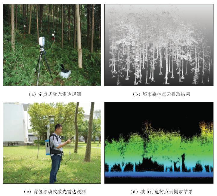
Lim K, Treitz P, Wulder M, et al. LiDAR remote sensing of forest structure[J]. Progress in Physical Geography:Earth and Environment, 2003(27):88-106.
[35]
Sun H, Wang G, Lin H, et al. Retrieval and accuracy assessment of tree and stand parameters for Chinese fir plantation using terrestrial laser scanning[J]. IEEE Geoscience and Remote Sensing Letter, 2015(12):1993-1997.
[36]
Iglhaut J, Cabo C, Puliti S, et al. Structure from motion photogrammetry in forestry:A review[J]. Current Forestry Reports, 2019,5(3):155-168.
doi: 10.1007/s40725-019-00094-3
[37]
Novo A, González-Jorge H, Martínez-Sánchez J, et al. Canopy detection over roads using mobile LiDAR data[J]. International Journal of Remote Sensing, 2020(41):51927-51942.
Guo Q H, Liu J, Li Y M, et al. A near-surface remote sensing platform for biodiversity monitoring:Perspectives and prospects[J]. Biodiversity Science, 2016,24(11):1249-1266.
doi: 10.17520/biods.2016059
[39]
蒋高明. 城市植被:特点、类型与功能[J]. 植物学通报, 1993(3):21-27.
Jiang G M. Urban vegetation:Its characteristic,type and function[J]. Chinese Bulletin Botany, 1993(3):21-27.
Qiu Y, Guan D S, Song W W, et al. The dust retention effect of urban vegetation in Huizhou,Guangdong Province[J]. Acat Ecologica Sinica, 2008(6):2455-2462.
[41]
Qiu G Y, Zou Z, Li X, et al. Experimental studies on the effects of green space and evapotranspiration on urban heat island in a subtropical megacity in China[J]. Habitat International, 2017(68):30-42.
[42]
Qiu G Y, Tan S, Wang Y, et al. Characteristics of evapotranspiration of urban lawns in a sub-tropical megacity and its measurement by the “Three Temperature Model + infrared remote sensing” method[J]. Remote Sensing, 2017(9):502.
[43]
Zou Z D, Yang Y J, Qiu G Y. Quantifying the evapotranspiration rate and its cooling effects of urban hedges based on Three-Temperature model and infrared remote sensing[J]. Remote Sensing, 2019(11):202.
[44]
Bowler D E, Buyung-Ali L, Knight T M, et al. Urban greening to cool towns and cities:A systematic review of the empirical evidence[J]. Landscape and Urban Planning, 2010,97(3):147-155.
[45]
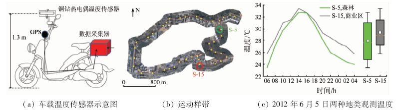
Stewart I, Oke T. Local climate zones for urban temperature studies[J]. Bulletin of the American Meteorological Society, 2012,93(12):1879-1900.
[46]
Yang J, Pyrgou A, Chong A, et al. Green and cool roofs’ urban heat island mitigation potential in tropical climate[J]. Solar Energy, 2018(173):597-609.
[47]
Oke T. City size and the urban heat island[J]. Atmospheric Environment, 1973,7(8):769-779.
[48]
Meehl G A, Tebaldi C. More intense,more frequent,and longer lasting heat waves in the 21st century[J]. Science, 2004(305):994-997.
[49]
Guerreiro S, Dawson R, Kilsby C, et al. Future heat-waves,droughts and floods in 571 European cities[J]. Environmental Research Letters, 2018,13(3):034009.
[50]
Oleson K, Anderson G, Jones B, et al. Avoided climate impacts of urban and rural heat and cold waves over the U.S. using large climate model ensembles for RCP8.5 and RCP4.5[J]. Climatic Change, 2018(146):377-392.
Qin D H. Climate change science and sustainable development[J]. Progress in Geography, 2014,33(7):874-883.
[52]
Grimmond C, Oke T. An evapotranspiration-interception model for urban areas[J]. Water Resources Research, 1991,27(7):1739-1755.
[53]
Qiu G Y, Yu X H, Wen H Y, et al. An advanced approach for measuring the transpiration rate of individual urban trees by the 3D three-temperature model and thermal infrared remote sensing[J]. Journal of Hydrology, 2020(587):125034.
[54]
Wang K, Dickinson R. A review on global terrestrial evapotranspiration:Observation,modeling,climatology,and climatic variability[J]. Reviews of Geophysics, 2012(50):569.
[55]
Zhang K, Kimball J, Running S. A review of remote sensing based actual evapotranspiration estimation[J]. Wiley Interdisciplinary Reviews-Water, 2016(3):834-853.
Chen F H, Fu B J, Xia J, et al. Major advances in studies of the physical geography and living environment of China during the past 70 years and future prospects[J]. Science China Earth Sciences, 2019,49(11):1659-1696.
[58]
Pataki D McCarthy H Litvak E, et al. Transpiration of urban forests in the Los Angeles metropolitan area[J]. Ecological Applications, 2011(21):661-677.
Wang X J, Kong F H, Yin H W, et al. Characteristics of vegetation shading and transpiration cooling effects during hot summer[J]. Acat Ecologica Sinica, 2018,38(12):4234-4244.
[60]
Segovia-Cardozo D, Rodríguez-Sinobas L, Zubelzu S. Living green walls:Estimation of water requirements and assessment of irrigation management[J]. Urban Forestry & Urban Greening, 2019(46):126458.
[61]
van de Wouw P, Brouwers H. Precipitation collection and evapo(transpi)ration of living wall systems:A comparative study between a panel system and a planter box system[J]. Building and Environment, 2017(126):221-237.
[62]
Costello L, Matheny N, Clark J, et al. A guide to estimating irrigation water needs of landscape plantings in California[R]. University of California Cooperative Extension,California Department of Water Resources, 2000.
[63]
Azeñas V, Janner I, Medrano H, et al. Performance evaluation of five Mediterranean species to optimize ecosystem services of green roofs under water-limited conditions[J]. Journal of Environmental Management, 2018(212):236-247.
[64]
Rana G, De Lorenzi F, Mazza G, et al. Tree transpiration in a multi-species Mediterranean garden[J]. Agricultural and Forest Meteorology, 2020(280):107767.
[65]
Li Z, Tang B, Wu H, et al. Satellite-derived land surface temperature:Current status and perspectives[J]. Remote Sensing of Environment, 2013(131):14-37.
doi: 10.1016/j.rse.2012.12.008
[66]
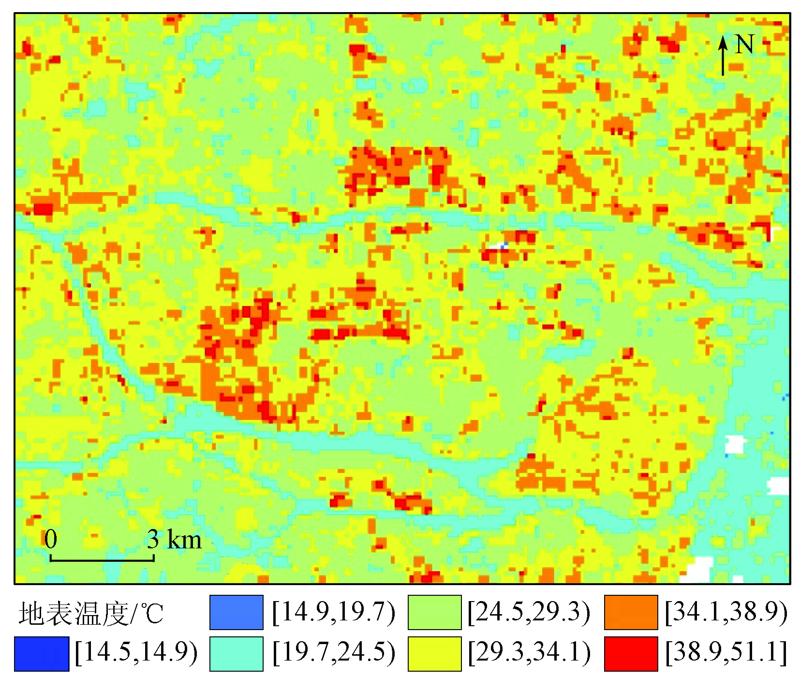
Chen X, Su Y, Li D, et al. Study on the cooling effects of urban parks on surrounding environments using Landsat TM data:A case study in Guangzhou,southern China[J]. International Journal of Remote Sensing, 2012(33):5889-5914.
doi: 10.1080/01431161.2012.676743
[67]
Feyisa G, Dons K, Meilby H. Efficiency of parks in mitigating urban heat island effect:An example from Addis Ababa[J]. Landscape and Urban Planning, 2014(123):87-95.
doi: 10.1016/j.landurbplan.2013.12.008
[68]
Cong Z, Shen Q, Zhou L, et al. Evapotranspiration estimation considering anthropogenic heat based on remote sensing in urban area[J]. Science China Earth Sciences, 2017(60):659-671.
[69]
Jiang Y, Weng Q. Estimation of hourly and daily evapotranspiration and soil moisture using downscaled LST over various urban surfaces[J]. GIScience & Remote Sensing, 2017,54(1):95-117.
[70]
Liu W, Hong Y, Khan S, et al. Actual evapotranspiration estimation for different land use and land cover in urban regions using Landsat 5 data[J]. Journal of Applied Remote Sensing, 2010(4):041873.
Zhang M X, Mei D Y, Gao W J, et al. Review on the applications of UAV remote sensing technology to urban green space monitoring[J]. Journal of Chinese Urban Forestry, 2019,17(5):5-11.
[72]
Mouw C, Greb S, Aurin D, et al. Aquatic color radiometry remote sensing of coastal and inland waters:Challenges and recommendations for future satellite missions[J]. Remote Sensing of Environment, 2015(160):15-30.
[73]
Xiong Y, Ran Y, Zhao S, et al. Remotely assessing and monitoring coastal and inland water quality in China:Progress,challenges and outlook[J]. Critical Reviews in Environmental Science and Technology, 2019,50(12), 1266-1302.
Ministry of Water Resources of the People’s Republic of China, National Bureau of Statistics of the People’s Republic of China. Bulletin of first National Census for Water[M]. Beijing: China Water and Power Press, 2013: 3.
 2021, Vol. 33
  ), 赵少华3, 鄢春华4, 邱国玉4, 孙华5,6,7, 王艳林8, 秦龙君4(