Surface features extraction of mining area image based on object-oriented and deep-learning method
CAI Xiang1,2(), LI Qi1, LUO Yan1, QI Jiandong1
1. School of Information Science & Technology, Beijing Forestry University, Beijing 100083, China 2. Engineering Research Center for Forestry-oriented Intelligent Information Processing of National Forestry and Grassland Administration, Beijing 100083, China
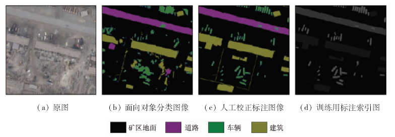
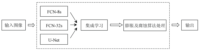
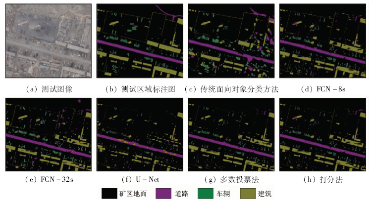
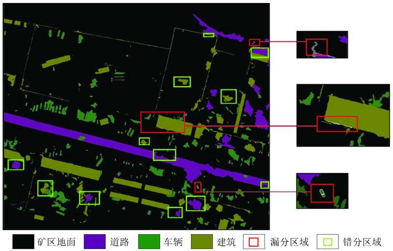
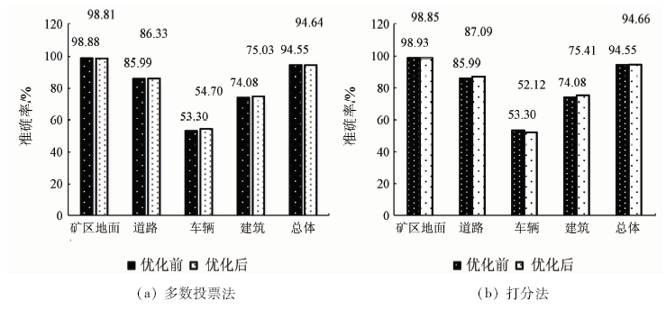
Acquisition of surface features of the mining area is greatly helpful to safe mining operation and management. In this paper, the authors propose an object-oriented combined with deep-learning classification method to extract surface features of the mining area based on unmanned aerial vehicle (UAV) images. Firstly, images are segmented by object-oriented method with manual correction to make annotation data set for deep learning models. Secondly, prepared training image data set is used to train 3 deep learning models (FCN-32s, FCN-8s and U-Net) and obtain 3 trained deep learning models respectively. Thirdly, classification accuracy is improved, and 2 integrate algorithms, which are majority voting algorithm and scoring algorithm based on these deep learning models, are proposed. The experimental results show that, compared with the single object-oriented classification method, the proposed methods have higher surface feature extraction accuracy and higher Kappa coefficient, from which the scoring integrate model has the best recognition effect. The overall accuracy of feature extraction on the testing image data set is 94.55%, which is 5.96 percentage points higher than the single object-oriented classification method, with the Kappa coefficient being 0.819 1.
蔡祥, 李琦, 罗言, 齐建东. 面向对象结合深度学习方法的矿区地物提取[J]. 国土资源遥感, 2021, 33(1): 63-71.
CAI Xiang, LI Qi, LUO Yan, QI Jiandong. Surface features extraction of mining area image based on object-oriented and deep-learning method. Remote Sensing for Land & Resources, 2021, 33(1): 63-71.
Li N, Li S R, Bao N S, et al. Research on optimal scale segmentation of typical land objects based on multi-source remote sensing data[J]. Hebei Remote Sensing, 2014(2):25-28.
Zhu Y F, Kuang R Y, Zhang G H. Research on the extracted information on ground objects in rare earth mining area based on ZY-1 02C image[J]. Journal of Jiangxi University of Science and Technology, 2018,39(3):40-47.
Sun J B, Zhang X Y, Niu L Y, et al. Farmland information extraction method based on high-resolution remotely-sensed images[J]. Shandong Agricultural Sciences, 2018,50(3):132-136,141.
Jing P P, Li B, Jia Z R, et al. Research on information extraction based on UAV remote Sensing[J]. Geomatics & Spatial Information Technology, 2017,40(12):77-80.
He S L, Xu J H, Zhang S Y. Land use classification of object-oriented multi-scale by UAV image[J]. Remote Sensing for Land and Resources, 2013,25(2):107-112.doi: 10.6046/gtzyyg.2013.02.19
Zhang J Y, Zhao Y L, Xiao W, et al. Rapid construction of mine line infrastructure using low-altitude unmanned aerial vehicle photogrammetry[J]. Bulletin of Surveying and Mapping, 2017(10):106-110.
[10]
韦国钧. 基于无人机影像快速发现可疑变化地物技术研究[D]. 南京:东南大学, 2018.
Wei G J. A research on the key technology of quickly detecting suspicious changed land-use based on UAV images[D]. Nanjing:Southeast University, 2018.
Xu X P. Application of UAV aerial surveying technology in landform measurement of mining area[J]. Resource Information and Engineering, 2018,33(3):114-115.
Shi W J, Zhang W J. Analyze the application of drone aerial photogrammetry technology in mine geological environment management[J]. Cultural Geography, 2017(9):81.
[13]
Mnih V, Hinton G E. Learning to detect roadsin high-resolution aerial images[C]// European Conference on Computer Vision.Berlin:Springer, 2010: 210-223.
Zheng Z, Zhang J D, Du J H. Research on ground collapse recognition in remote sensing images based on deep learning[J]. Modern Business Trade Industry, 2017(35):189-192.
Xiang Y, Zhao Y D, Dong J H. Remote sensing image mining area change detection based on improved UNet siamese network[J]. Journal of China Coal Society, 2019,44(12):3773-3780.
[16]
马浩然. 基于多层次分割的遥感影像面向对象森林分类[D]. 北京:北京林业大学, 2014.
Ma H R. Object-based remote sensing image classification of forest based on multi-level segmentation[D]. Beijing:Beijing Forestry University, 2014.
Zhou L J, Chen X F, Yang L J. Object-based standard nearest neighbor classification used in national geomatics monitoring[J]. Geomatics & Spatial Information Technology, 2016,39(5):155-157.
[18]
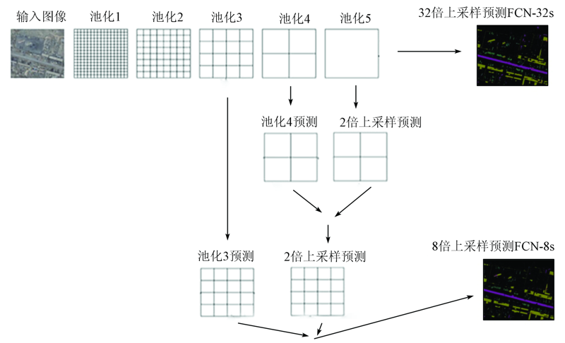
Long J, Shelhamer E, Darrell T. Fully convolutional networks for semantic segmentation[J]. IEEE Transactions on Pattern Analysis & Machine Intelligence, 2014,39(4):640-651.
pmid: 27244717
[19]
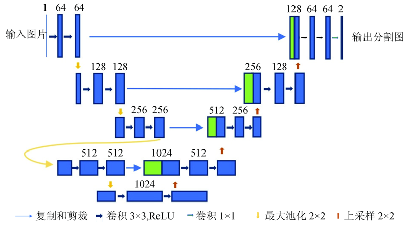
Ronneberger O, Fischer P, Brox T. U-Net:Convolutional networks for biomedical image segmentation[C]// International Conference on Medical Image Computing and Computer-Assisted Intervention.Berlin:Springer, 2015: 234-241.
 2021, Vol. 33
  ), 李琦1, 罗言1, 齐建东1