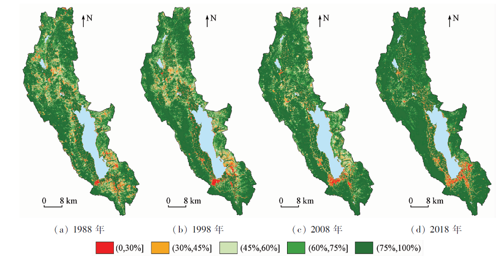
As an important indicator reflecting the surface ecological environment, vegetation is widely used in the study of regional resources and environmental carrying capacity. Taking Erhai Lake basin as an example and based on the Google Earth Engine remote sensing big data cloud computing platform, the authors obtained the annual maximum normalized difference vegetation index (NDVI) value of Erhai Lake basin in 1988—2018 by using nearly 455 Landsat series images with 30 m resolution. The pixel binary model was used for quantitative estimation of fractional vegetation cover (FVC), and the spatial-temporal change characteristics of FVC in Erhai Lake basin were comprehensively analyzed through the linear regression model. Additionally, the internal relationship between FVC and geological lithology was investigated. The results are as follows: (1) From 1988 to 2018, the vegetation coverage of Erhai Lake basin showed a trend of continuous fluctuation growth, with a growth rate of 0.38%/a. (2) The basin was dominated by high vegetation coverage, of which 82.54% of the regional vegetation coverage continued to be improved, whereas the area of continuous degradation accounted for only 3.27%, which was mainly distributed in the area with significant urbanization. (3) the FVC varied in different types of lithological areas, among which the highest was metamorphic rock, and the lowest was dolomite and volcanic rock.
陈虹, 郭兆成, 贺鹏. 1988—2018年间洱海流域植被覆盖度时空变换特征探究[J]. 国土资源遥感, 2021, 33(2): 116-123.
CHEN Hong, GUO Zhaocheng, HE Peng. Spatial and temporal change characteristics of vegetation coverage in Erhai Lake basin during 1988—2018. Remote Sensing for Land & Resources, 2021, 33(2): 116-123.
Jong R D, Bruin S D, Wit A D, et al. Analysis of monotonic greening and browning trends from global NDVI time-series[J]. Remote Sensing of Environment, 2011, 115(2):692-702.
doi: 10.1016/j.rse.2010.10.011
[2]
Gitelson A A, Kaufman Y J, Stark R, et al. Novel algorithms for remote estimation of vegetation fraction[J]. Remote Sensing of Environment, 2002, 80(1):76-87.
doi: 10.1016/S0034-4257(01)00289-9
Jia K, Yao Y J, Wei X Q, et al. A review on fractional vegetation cover estimation using remote sensing[J]. Advances in Earth Science, 2013, 28(7):774-782.
[4]
Voorde T V D, Vlaeminck J, Canters F. Comparing different approaches for mapping urban vegetation cover from Landsat ETM+ data:A case study on Brussels[J]. Sensors, 2008, 8(6):3880-3902.
pmid: 27879914
[5]
Zhang X, Liao C, Li J, et al. Fractional vegetation cover estimation in arid and semi-arid environments using HJ-1 satellite hyperspectral data[J]. International Journal of Applied Earth Observation and Geoinformation, 2013, 21(1):506-512.
doi: 10.1016/j.jag.2012.07.003
Li M M, Wu B F, Yan C Z, et al. Estimation of vegetation fraction in the upper basin of Miyun reservoir by remote sensing[J]. Resource Science, 2004, 26(4):153-159.
Chen X Q, Wang H. Spatial and temporal variations of vegetation belts and vegetation cover degrees in inner Mongolia from 1982 to 2003[J]. Acta Geographica Sinica, 2009, 64(1):84-94.
Liu X F, Zhu X F, Pan Y Z, et al. Spatiotemporal changes in vegetation coverage in China during 1982—2012[J]. Acta Ecologica Sinica, 2015, 35(16):59-70.
Liu X F, Pan Y Z, Zhu X F, et al. Spatiotemporal variation of vegetation coverage in Qinling-Daba Mountains in relation to environmental factors[J]. Acta Geographica Sinica, 2015, 70(5):705-716.
Zheng Z J, Zeng Y, Zhao Y J, et al. Monitoring and dynamic analysis of fractional vegetation cover in southwestern China over the past 15 years based on MODIS data[J]. Remote Sensing for Land and Resources, 2017, 29(3):128-136.doi: 10.6046/gtzyyg.2017.03.19.
doi: 10.6046/gtzyyg.2017.03.19
Fang S B, Tan K Y, Liu J D, et al. Vegetation cover and its relationship with environmental factors at different scales in the Ordos region of China[J]. Chinese Journal of Plant Ecology, 2009, 33(1):30-38.
[12]
Amiri R, Weng Q, Alimohammadi A, et al. Spatial-temporal dynamics of land surface temperature in relation to fractional vegetation cover and land use/cover in the Tabriz urban area,Iran[J]. Remote Sensing of Environment, 2009, 113(12):2606-2617.
doi: 10.1016/j.rse.2009.07.021
Zhang X D, Liu X N, Zhao Z P, et al, Spatial-temporal pattern analysis of the vegetation coverage and geological hazards in Yanchi county based on dimidiate pixel model[J]. Remote Sensing for Land and Resources, 2018, 30(2):195-201.doi: 10.6046/gtzyyg.2018.02.26.
doi: 10.6046/gtzyyg.2018.02.26
Pei J, Niu Z, Wang L, et al, Monitoring to variations of vegetation cover using long-term time series remote sensing data on the Google Earth Engine cloud platform[J]. Carsologica Sinica, 2018, 37(4):136-144.
[16]
Busetto L, Meroni M, Colombo R. Combining medium and coarse spatial resolution satellite data to improve the estimation of sub-pixel NDVI time series[J]. Remote Sensing of Environment, 2008, 112(1):118-131.
doi: 10.1016/j.rse.2007.04.004
[17]
Leprieur C, Verstraete M M, Pinty B. Evaluation of the performance of various vegetation indices to retrieve vegetation cover from AVHRR data[J]. Remote Sensing Reviews, 1994, 10(4):265-284.
doi: 10.1080/02757259409532250
Li M M. The method of vegetation fraction estimation by remote sensing[D]. Beijing:Graduate School of Chinese Academy of Sciences(Institute of Remote Sensing Applications), 2003.
[19]
Stow D, Daeschner S, Hope A, et al. Variability of the seasonally integrated normalized difference vegetation index across the north slope of Alaska in the 1990s[J]. International Journal of Applied Earth Observation and Geoinformation, 2003, 24(5):1111-1117.
Xi D M, Deng W D, Gao H G, et al. Physico-chemical properties of rocks and soils and abundances of minerals in main geological background areas in Yunnan province[J]. Soils, 2008, 40(1):114-120.
Zhang M K, Yao Y C, Qiu Z T, et al. Pedogenetic characteristics and taxonomic classification of soils developed from carbonate rocks in the south of China[J]. Journal of Zhejiang University(Agriculture and Life Sciences), 2019, 45(1):60-71.
Xu Y, Deng Y, Cao J H, et al. Comparative analysis of soil trace elements in different land use types in Xiaojiang river basin,Yunnan[J]. Carsologica Sinica, 2018, 37(5):116-124.
 2021, Vol. 33
  ), 郭兆成(