ZHANG Aizhu1,2(), WANG Wei1, ZHENG Xiongwei3, YAO Yanjuan4, SUN Genyun1,2(), XIN Lei5, WANG Ning5, HU Guang6
1. College of Oceanography and Space Informatics, China University of Petroleum (East China), Qingdao 266580, China 2. Laboratory for Marine Resources Qingdao National Laboratory for Marine Science and Technology, Qingdao 266237,China 3. China Aero Geophysical Survey and Remote Sensing Center for Natural Resources, Beijing 100083,China 4. Satellite Environment Center, Ministry of Environmental protection of China, Beijing 100094, China 5. North China Sea Marine Forecasting Center of State Oceanic Administration, Qingdao 266061,China 6. Wuhan SunMap RS Techology Co., Ltd., Wuhan 430223, China
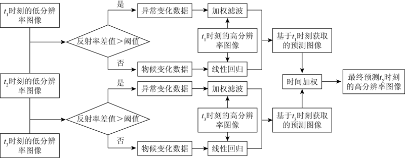
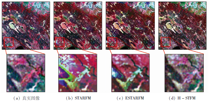
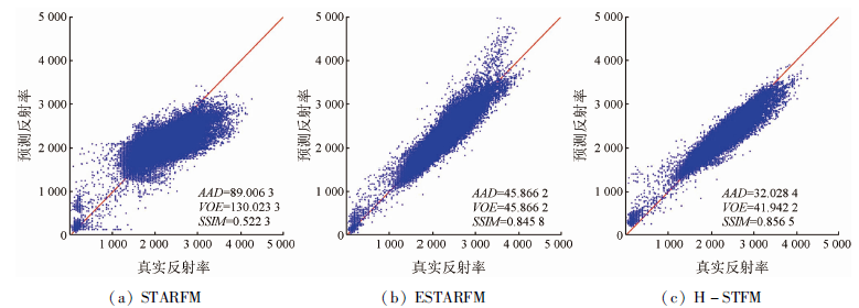
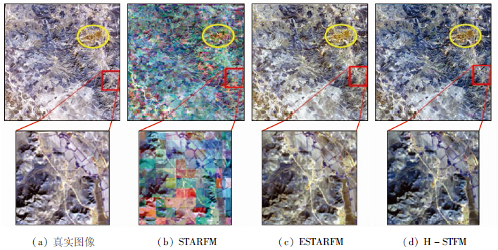
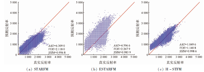
The temporal resolution of high spatial resolution remote sensing data can be effectively improved by spatio-temporal fusion of remote sensing data. However, the most widely used spatial and temporal adaptive reflectance fusion model (STARFM) fails to achieve highly accurate prediction effects for areas with abrupt changes at present. Given this, this paper proposed a hierarchical spatial-temporal fusion model (H-STFM). In this model, the target pixels to be predicted are divided into pixels with phenological change and pixels with abrupt changes, which are predicted using linear regression and weighted filtering methods, respectively. Then the prediction results of the two types of pixels are fused using an optimized time weighted function to form the final prediction map. The H-STFM proposed in this paper was qualitatively and quantitatively assessed using two sets of medium-resolution remote sensing images from moderate resolution imaging spectrometer (MODIS) and Landsat satellite. As indicated by the experiment results, H-STFM is significantly superior to STARFM in terms of structural similarity and relative dimensionless global error.
Wu M Q, Niu Z, Wang C Y. Assessing the accuracy of spatial and temporal image fusion model of complex area in south China[J]. Journal of Geo-Information Science, 2014, 16(5):776-783.
[2]
Hilker T, Wulder M A, Coops N C, et al. Generation of dense time series synthetic Landsat data through data blending with MODIS using a spatial and temporal adaptive reflectance fusion model[J]. Remote Sensing of Environment, 2009, 113(9):1988-1999.
doi: 10.1016/j.rse.2009.05.011
[3]
Dong T F, Liu J G, Qian B D, et al. Estimating winter wheat biomass by assimilating leaf area index derived from fusion of Landsat-8 and MODIS data[J]. International Journal of Applied Earth Observation and Geoinformation, 2016, 49:63-74.
doi: 10.1016/j.jag.2016.02.001
[4]
Shen H F, Huang L W, Zhang L P, et al. Long-term and fine-scale satellite monitoring of the urban heat island effect by the fusion of multi-temporal and multi-sensor remote sensed data:A 26-year case study of the city of Wuhan in China[J]. Remote Sensing of Environment, 2016, 172:109-125.
doi: 10.1016/j.rse.2015.11.005
[5]
Weng Q H, Fu P, Gao F. Generating daily land surface temperature at Landsat resolution by fusing Landsat and MODIS data[J]. Remote Sensing of Environment, 2014, 145:55-67.
doi: 10.1016/j.rse.2014.02.003
[6]
Kong F J, Li X B, Wang H, et al. Land cover classification based on fused data from GF-1 and MODIS NDVI time series[J]. Remote Sensing, 2016, 8:741.
doi: 10.3390/rs8090741
[7]
Liu H, Weng Q H. Enhancing temporal resolution of satellite imagery for public health studies:A case study of West Nile Virus outbreak in Los Angeles in 2007[J]. Remote Sensing of Environment, 2012, 117:57-71.
doi: 10.1016/j.rse.2011.06.023
[8]
Wu M, Wu C, Huang W, et al. An improved high spatial and temporal data fusion approach for combining Landsat and MODIS data to generate daily synthetic Landsat imagery[J]. Information Fusion, 2016, 31:14-25.
doi: 10.1016/j.inffus.2015.12.005
[9]
Fu D, Chen B, Wang J, et al. An improved image fusion approach based on enhanced spatial and temporal the adaptive reflectance fusion model[J]. Remote Sensing, 2013, 5(12):6346-6360.
doi: 10.3390/rs5126346
[10]
Huang B, Song H. Spatiotemporal reflectance fusion via sparse representation[J]. IEEE Transactions on Geoscience and Remote Sensing, 2012, 50(10):3707-3716.
doi: 10.1109/TGRS.2012.2186638
Huang B, Zhao Y Q. Research status and prospect of spatiotemporal fusion of multi-source satellite remote sensing imagery[J]. Acta Geodaetica et Cartographica Sinica, 2017, 46(10):1492-1499.
[12]
Chen B, Chen L, Huang B, et al. Dynamic monitoring of the Poyang Lake wetland by integrating Landsat and MODIS observations[J]. ISPRS Journal of Photogrammetry and Remote Sensing, 2018, 139:75-87.
doi: 10.1016/j.isprsjprs.2018.02.021
Cai D W, Niu Z, Wang L. Adaptability research of spatial and temporal remote sensing data fusion technology in crop monitoring[J]. Remote Sensing Technology and Application, 2012, 27(6):927-932.
[14]
Ping B, Meng Y, Su F. An enhanced linear spatio-temporal fusion method for blending landsat and MODIS data to synthesize landsat-like imagery[J]. Remote Sensing, 2018, 10(6):881.
doi: 10.3390/rs10060881
[15]
Gao F, Masek J, Schwaller M, et al. On the blending of the Landsat and MODIS surface reflectance:Predicting daily Landsat surface reflectance[J]. IEEE Transactions on Geoscience and Remote Sensing, 2006, 44(8):2207-2218.
doi: 10.1109/TGRS.2006.872081
[16]
Gevaert C M, Garcia-haro F J. A comparison of STARFM and an unmixing-based algorithm for Landsat and MODIS data fusion[J]. Remote Sensing of Environment, 2015,(156):34-44.
[17]
Hilker T, Wulder M A, Coops N C, et al. A new data fusion model for high spatial-and temporal-resolution mapping of forest disturbance based on Landsat and MODIS[J]. Remote Sensing of Environment, 2009, 113(8):1613-1627.
doi: 10.1016/j.rse.2009.03.007
[18]
Zhu X, Chen J, Gao F, et al. An enhanced spatial and temporal adaptive reflectance fusion model for complex heterogeneous regions[J]. Remote Sensing of Environment, 2010, 114(11):2610-2623.
doi: 10.1016/j.rse.2010.05.032
[19]
Belgiu M, Stein A. Spatiotemporal image fusion in remote sensing[J]. Remote Sensing, 2019, 11(7):818.
doi: 10.3390/rs11070818
Fang S, Yao Z J, Cao F Y. Spatio-temporal method of satellite image fusion based on linear model[J]. Journal of Image and Graphics, 2020, 25(3):579-592
[21]
Cheng Q, Liu H Q, Shen H F, et al. A spatial and temporal nonlocal filter-based data fusion method[J]. IEEE Transactions on Geoscience and Remote Sensing, 2017, 55(8):4476-4488.
doi: 10.1109/TGRS.2017.2692802
[22]
Wang Q, Atkinson P M. Spatio-temporal fusion for daily Sentinel-2 images[J]. Remote Sensing of Environment, 2018(204):31-42.
Liu H Q, Wu P H, Shen H F, et al. A spatio-temporal information fusion method based on non-local means filter[J]. Geography and Geo-Information Science, 2015, 31(4):27-32.
[24]
Karydas C, Jiang B. Scale optimization in topographic and hydrographic feature mapping using fractal analysis[J]. ISPRS International Journal of Geo-Information, 2020, 9(11):631.
doi: 10.3390/ijgi9110631
Wang M Z, Xu W X, Wang L, et al. Research progress on endmember extraction algorithm and its classification of hyperspectral remote sensing imagery[J]. Remote Sensing Technology and Application, 2015, 30(4):616-625.
Liu H H, Yang W N, Yang R H. The end-member extraction and analysis method for rocks and minerals using hyperspectral remote sensing image[J]. Acta Petrologica et Mineralogica, 2013(2):213-220.
 2021, Vol. 33
  ), 王伟1, 郑雄伟3, 姚延娟4, 孙根云1,2(