Ecological vulnerability assessment of the Yellow River basin based on partition-integration concept
YANG Wenna1,2(), ZHOU Liang1,3,4(), SUN Dongqi3
1. Faculty of Geomatics, Lanzhou Jiaotong University, Lanzhou 730070, China 2. National-Local Joint Engineering Research Center of Technologies and Applications for National Geographic State Monitoring, Lanzhou 730070, China 3. Institute of Geographic Sciences and Natural Resources Research/State Key Laboratory of Resources and Environment Information System, Beijing 100101, China 4. Gansu Provincial Engineering Laboratory for National Geographic State Monitoring, Lanzhou 730070, China
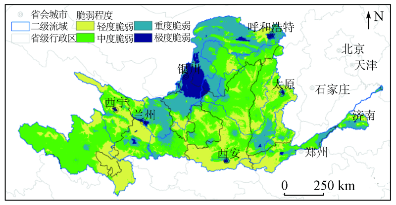
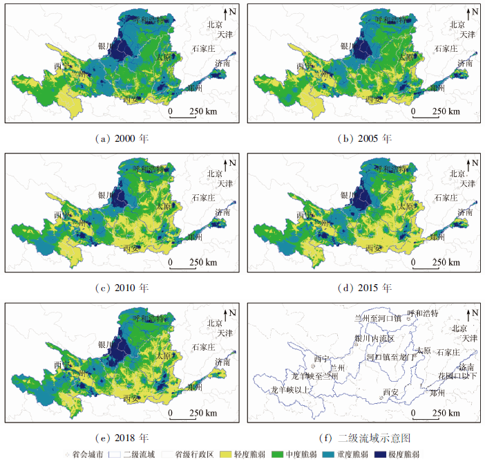
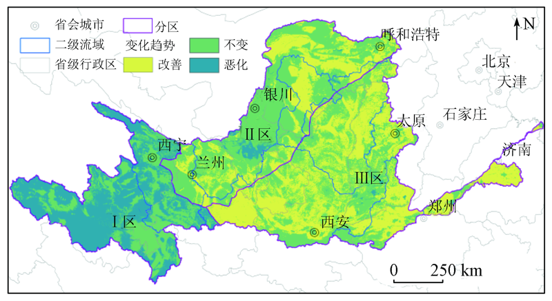
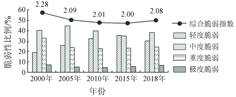
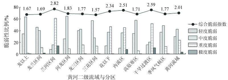
The Yellow River basin is an important ecological safety barrier, an agglomeration area of resource and energy, and an area with highly intensive production activities in China. Therefore, its ecological change directly affects the sustainable development of the ecological environment and economy in the basin. This paper aims to quantitatively assess the ecological vulnerability and analyze the spatial heterogeneity in the Yellow River basin. To this end, an evaluation system was established using the partition-integration assessment method by selecting indicators such as water resources, climate, soil, vegetation, and human activities. Meanwhile, a multiplication model was introduced. The assessment results are as follows. The overall ecological environment in the basin is moderately vulnerable, with moderately vulnerable areas accounting for 42.37% of the total area of the basin. Meanwhile, the areas with a highly vulnerable ecological environment in the basin are mainly distributed in the urban economic belt along the upper mainstream of the Yellow River. From 2000 to 2018, the ecological vulnerability of the basin first decreased and then increased. During this period, ecological problems were the most notable in 2000 and ecological vulnerability was the lowest in 2015, with the Comprehensive Vulnerability Index (CVI) of 2.28 and 2.00, respectively in 2000 and 2015. The ecological vulnerability and its evolution trend in the basin significantly varied in space. In detail, the ecological vulnerability notably increased in the plateau areas in the upper reaches, slightly changed in the urban belt along the river, and significantly decreased in the middle and lower reaches.
杨雯娜, 周亮, 孙东琪. 基于分区-集成的黄河流域生态脆弱性评价[J]. 自然资源遥感, 2021, 33(3): 211-218.
YANG Wenna, ZHOU Liang, SUN Dongqi. Ecological vulnerability assessment of the Yellow River basin based on partition-integration concept. Remote Sensing for Natural Resources, 2021, 33(3): 211-218.
Luo Y C, Zhou Z X, Sun Y, et al. Assessment methods of watershed ecosystem health[J]. Acta Ecologica Sinica, 2003, 23(8):1606-1614.
[2]
Zhang F, Liu X P, Zhang J Q, et al. Ecological vulnerability assessment based on multi-sources data and SD model in Yinma River Basin,China[J]. Ecological Modelling, 2017, 349(7):41-50.
doi: 10.1016/j.ecolmodel.2017.01.016
[3]
Zhou L, Xu J G, Sun D Q. Zoning assessment of water environmental supporting capacity of socioeconomic development in the Huaihe River Basin,China[J]. Journal of Geographical Sciences, 2015, 25(10):1199-1217.
doi: 10.1007/s11442-015-1228-1
[4]
Beroya-Eitner M A. Ecological vulnerability indicators[J]. Ecological Indicators, 2016, 60(1):329-334.
doi: 10.1016/j.ecolind.2015.07.001
[5]
Ahn S R, Kim S J. Assessment of integrated watershed health based on the natural environment,hydrology,water quality,and aquatic ecology[J]. Hydrology and Earth System Science, 2017, 21(11):5583-5602.
doi: 10.5194/hess-21-5583-2017
Zhou Z H. Collection and processing of binary information of Yellow River Basin[M]//Wang H.Research on water resources and its evolution law of the Yellow River Basin. Beijing: Science Press, 2010:61-66.
Chen Y, Zhang K Y, Chen X D, et al. Ecological protection and high-quality development of the Yellow River Basin[J]. Regional Economic Review, 2020(1):8-22.
Zhou R P. Assessing the soil erosion control service in the typical area of Loess Plateau[J]. Remote Sensing for Land and Resources, 2019, 31(2):131-139.doi: 10.6046/gtzyyg.2019.02.19.
doi: 10.6046/gtzyyg.2019.02.19
Wu C S, Huang C, Liu G H, et al. Assessment of ecological vulnerability in the Yellow River Delta using the Fuzzy Analytic Hierarchy Process[J]. Acta Ecologica Sinica, 2018, 8(13):4584-4595.
Sun B, Sun Y J, Tian L. A remote sensing investigation of waterlands in Yellow River Basin[J]. Remote Sensing for Land and Resources, 2010(s1):144-147.doi: 10.6046/gtzyyg.2010.s1.30.
doi: 10.6046/gtzyyg.2010.s1.30
Chen J W, Zeng Q M, Jiao J, et al. SBAS time series analysis technique based on Sentinel-1A TOPS SAR images:A case study of Yellow River Delta[J]. Remote Sensing for Land and Resources, 2017, 29(4):82-87.doi: 10.6046/gtzyyg.2017.04.13
doi: 10.6046/gtzyyg.2017.04.13
Lu D D, Sun D Q. Development and management tasks of the Yellow River Basin:A preliminary understanding and suggestion[J]. Acta Geographica Sinica, 2019, 74(12):2431-2436.
Li X Q, Tian L, Yu Z F. Remote sensing monitoring of soil erosion in the Yellow River Basin[J]. Remote Sensing for Land and Resources, 2009(4):57-61,67.doi: 10.6046/gtzyyg.2009.04.12.
doi: 10.6046/gtzyyg.2009.04.12
[15]
Wang G Q, Zhang J Y, Jin J L, et al. Impacts of climate change on water resources in the Yellow River basin and identification of global adaptation strategies[J]. Mitigation and Adaptation Strategies for Global Change, 2017(22):67-83.
Li M, Zhang C Y, Wang H Y. Research on the stages of soil and water conservation management in the Loess Plateau[J]. Soil and Water Conservation in China, 2019(2):1-4.
Chen J, Du P J, Tan K. An improved unsupervised classification scheme for polarimetric SAR image with MCSM-Wishart[J]. Remote Sensing for Land and Resources, 2015, 27(2):15-21.
[18]
Guo B, Fan Y W, Yang F, et al. Quantitative assessment model of ecological vulnerability of the Silk Road Economic Belt,China,utilizing remote sensing based on the partition-integration concept[J]. Geomatics,Natural Hazards and Risk, 2019(10):1346-1366.
Peng S M, Zheng X K, Wang Y, et al. Study on integrated allocation and dispatch model of water quality and quantity for the Yellow River[J]. Advances in Water Science, 2016, 27(2):196-205.
Hao Z X, Zheng J Y, Ge Q S, et al. Analysis of the relationship between precipitation and infiltration depth in the middle and lower reaches of the Yellow River and the Jianghuai Basin[J]. Progress in Natural Science, 2008(6):662-667.
[21]
Guo B, Zhou Y, Zhu J F, et al. Spatial patterns of ecosystem vulnerability changes during 2001—2011 in the three-river source region of the Qinghai-Tibetan Plateau,China[J]. Journal of Arid Land, 2015, 8(1):23-35.
doi: 10.1007/s40333-015-0055-7
Wang S, Fu B J, Wu X T, et al. Dynamics and sustainability of social-ecological systems in the Loess Plateau[J]. Resources Science, 2020, 42(1):96-103.
Wang Q, Lu C, Fan Z P, et al. River habitat quality assessment based on principal component analysis and entropy weight in Qinghe River as a case[J]. Ecological Science, 2017, 36(4):185-193.
Shao Q F, Peng P H, Huang J, et al. Monitoring ecoenvironmental vulnerability in Anning River Basin in the upper reaches of the Yangtze River using remote sensing techniques[J]. Remote Sensing for Land and Resources, 2016, 28(2):175-181.doi: 10.6046/gtzyyg.2016.02.27.
doi: 10.6046/gtzyyg.2016.02.27
[25]
Zhou H, Deng Z, Xia Y, et al. A new sampling method in particle filter based on Pearson correlation coefficient[J]. Neurocomputing, 2016:208-215.
 2021, Vol. 33
  ), 周亮1,3,4(