Active deep learning based polarimetric SAR image classification
Jia XU1,4(), Chunqi YUAN1,2, Yuane CHENG3, chenyu ZENG5, Kang XU4
1. School of Earth Sciences and Engineering, Hohai University, Nanjing 211100, China 2. North Information Control Group, Nanjing 211153, China 3. Jiangsu Province Surveying & Mapping Research Institute, Nanjing 210013, China; 4. Jiangsu Province Surveying & Mapping Engineering Institute, Nanjing 210013, China; 5. School of Software Central South University, Changsha 410075, China
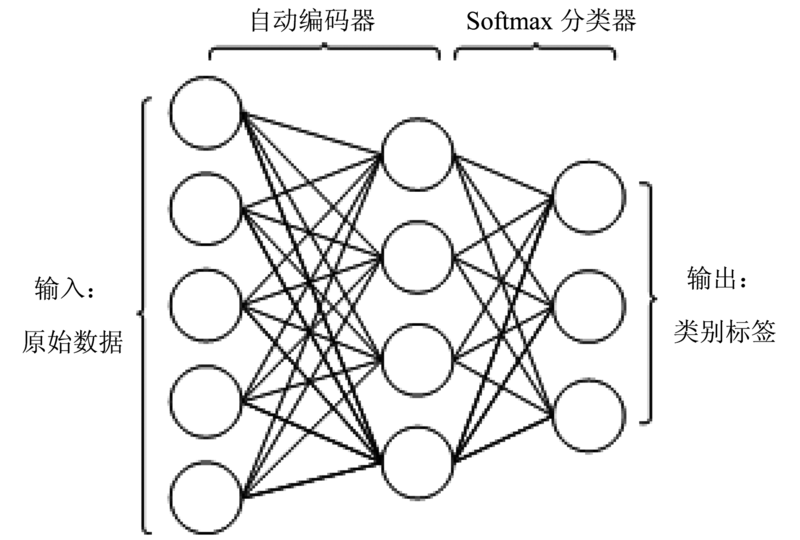
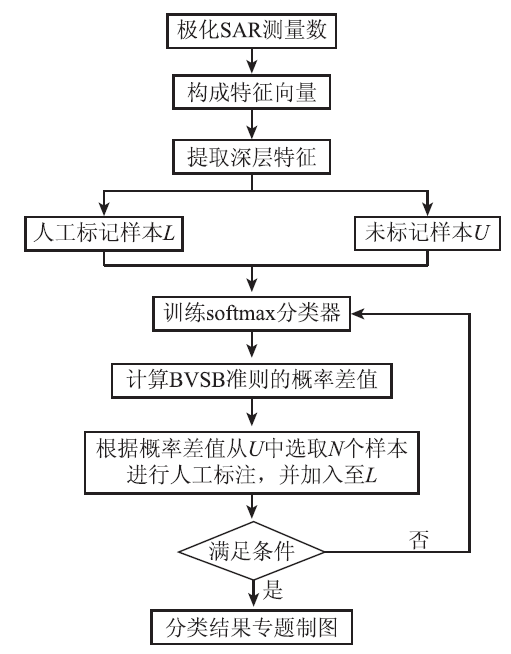
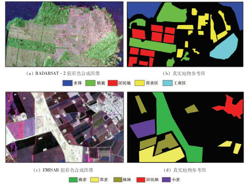
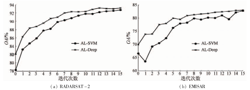
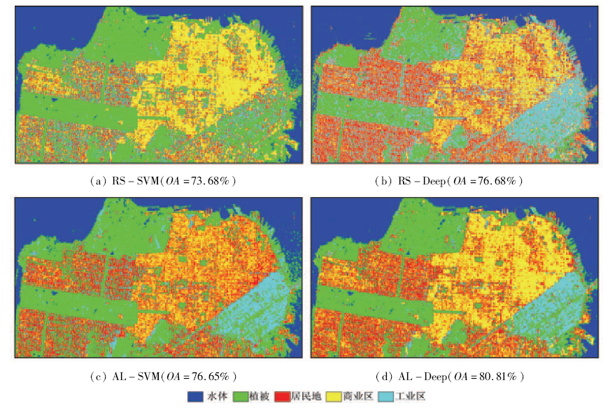
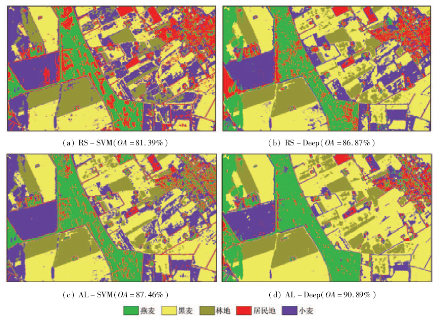
Supervised classification methods usually require adequate labeled samples which are difficult and time-consuming to obtain for polarimetric SAR images, while the expression capability of the shallow structure learning algorithm is limited. A novel supervised classification method for polarimetric SAR imagery based on active deep learning is proposed in this paper. Firstly, the features are extracted from an original image by multiple polarization target decomposition methods for fully describing the data,and the features which are separable and invariable can be extracted with unsupervised learning by auto-encoder. Then, the initial classifier is trained and fine-tune the whole model with a small number of labeled samples. Finally, the most valuable samples (the largest ambiguity samples for classifier)are selected to label by active learning. Experimental results in comparison with conventional methods for polarimetric SAR data sets of RADARSAT-2 and EMISAR show that the proposed method can achieve higher classification accuracy with a small number of labeled samples.
Qi Z X,Yeh A G O,Li X, et al.Monthly short-term detection of land development using RADARSAT-2 polarimetric SAR imagery[J].Remote Sensing of Environment,2015,164:179-196.
[2]
Yu P,Qin A K,Clausi D A.Unsupervised polarimetric SAR image segmentation and classification using region growing with edge penalty[J].IEEE Transactions on Geoscience and Remote Sensing,2012,50(4):1302-1317.
Chen J,Du P J,Tan K.An improved unsupervised classification scheme for polarimetric SAR image with MCSM-Wishart[J].Remote Sensing for Land and Resources,2015,27(2):15-21.doi:10.6046/gtzyyg.2015.02.03.
[4]
Samat A,Du P J,Baig M H A,et al.Ensemble learning with multiple classifiers and polarimetric features for polarized SAR image classification[J].Photogrammetric Engineering & Remote Sensing,2014,80(3):239-251,doi:10.14358/PERS.80.3.239.
[5]
Zhang Y H,Zhang J X,Zhang X F,et al.Land cover classification from polarimetric SAR data based on image segmentation and decision trees[J].Canadian Journal of Remote Sensing,2015,41(1):40-50.
[6]
Uhlmann S,Kiranyaz S,Gabbouj M.Semi-supervised learning for ill-posed polarimetric SAR classification[J].Remote Sensing,2014,6(6):4801-4830.
[7]
Liu H Y,Wang Y K,Yang S Y,et al.Large polarimetric SAR data semi-supervised classification with spatial-anchor graph[J].IEEE Journal of Selected Topics in Applied Earth Observations and Remote Sensing,2016,9(4):1439-1458.
Chen R,Cao Y F,Sun H.Multi-class image classification with active learning and semi-supervised learning[J].Acta Automatica Sinica,2011,37(8):954-962.
[9]
Samat A,Gamba P,Du P J,et al.Active extreme learning machines for quad-polarimetric SAR imagery classification[J].International Journal of Applied Earth Observation and Geoinformation,2015,35:305-319.
[10]
Joshi A J,Porikli F,Papanikolopoulos N.Multi-class active learning for image classification[C]//2009 IEEE Conference on Computer Vision and Pattern Recognition.Miami,FL:IEEE,2009:2372-2379.
[11]
Bengio Y.Learning deep architectures for AI[J].Foundations and Trends® in Machine Learning,2009,2(1):1-127.
[12]
Cloude S R,Pottier E.A review of target decomposition theorems in radar polarimetry[J].IEEE Transactions on Geoscience and Remote Sensing,1996,34(2):498-518.
[13]
Rumelhart D E,Hinton G E,Williams R J.Learning representations by back-propagating errors[J].Nature,1986,323(6088):533-536.
[14]
Chen Y S,Lin Z H,Zhao X,et al.Deep learning-based classification of hyperspectral data[J].IEEE Journal of Selected Topics in Applied Earth Observations and Remote Sensing,2014,7(6):2094-2107.
 2018, Vol. 30
  ), 袁春琦1,2, 程圆娥3, 曾晨雨5, 许康4