Please wait a minute...
 
国土资源遥感  2018, Vol. 30 Issue (1): 128-134    DOI: 10.6046/gtzyyg.2018.01.18
  本期目录 | 过刊浏览 | 高级检索 |
基于高分辨率遥感数据的稀有金属矿化带勘查
范玉海1,2(), 王辉1,2, 杨兴科1, 彭齐鸣3, 秦绪文4, 杨金中5, 张少鹏2, 谭富荣2
1.长安大学地球科学与国土资源学院,西安 710054
2.中煤航测遥感局地质勘查院,西安 710054
3.国土资源部,北京 100812
4.中国地质调查局,北京 100037
5.中国国土资源航空物探遥感中心,北京 100083
Application of high-resolution remote sensing technology to the prospecting for rare metal mineralization belt
Yuhai FAN1,2(), Hui WANG1,2, Xingke YANG1, Qiming PENG3, Xuwen QIN4, Jinzhong YANG5, Shaopeng ZHANG2, Furong TAN2
1. School of Earth Science and Land and Resources, Chang’an University, Xi’an 710054, China;
2. Geological Exploration Institute of Aerial Photogrammetry and Remote Sensing Bureau, Xi’an 710054, China;
3. Ministry of Land and Resources, Beijing 100812, China
4. China Geological Survey, Beijing 100037, China
5. Chian Aero Geophysical Survey and Remote Sensing Center for Land and Resources, Beijing 100083, China
全文: PDF(1692 KB)   HTML  
输出: BibTeX | EndNote (RIS)      
摘要 

以西昆仑大红柳滩地区花岗伟晶岩型稀有金属矿化带为研究对象,以WorldView-2高空间分辨率数据为主要信息源,在影像图制作的基础上,有针对性地进行图像增强处理,突出控矿要素和矿化信息,开展该矿种的遥感综合解译; 利用ASTER数据开展与花岗伟晶岩型稀有金属成(控)矿作用相关的异常信息提取; 配合适量的野外查证,分析其高分辨率遥感特征及成矿地质条件,建立遥感地质找矿模型。结果表明,利用高分辨率遥感卫星数据为主的数据源能够快速圈定找矿有利地段,满足西昆仑大红柳滩地区稀有金属矿勘查和资源评价需求,可为在相同或类似地区开展此类工作提供借鉴。

服务
把本文推荐给朋友
加入引用管理器
E-mail Alert
RSS
作者相关文章
范玉海
王辉
杨兴科
彭齐鸣
秦绪文
杨金中
张少鹏
谭富荣
关键词 高分辨率遥感花岗伟晶岩型稀有金属西昆仑大红柳滩地区地质找矿    
Abstract

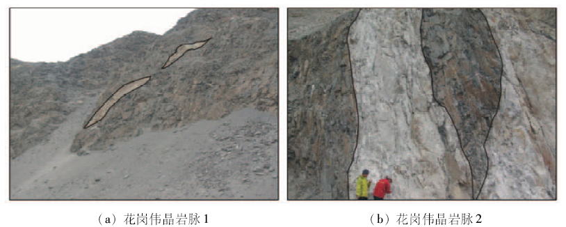
With rare metals of granite pegmatite type in the Dahongliutan area of West Kunlun Mountains as the study object and WorldView-2 remote sensing images as the major data source, the authors drew standard image map, adopted methods of image enhancement for protruding the information of ore-controlling factors and mineralization, and finally carried out an interpretation of remote sensing for mineral resources. On the basis of alteration anomaly information extraction for rare metals of granite pegmatite type by using ASTER data and a right amount of field verification, its high-resolution remote sensing characteristics and metallogenic geological conditions were analyzed, and a remote sensing geological prospecting model was established. Tt can provide the basis for finding similar minerals in the West Kunlun metallogenic belt in future. The results show that the remote sensing technology using high resolution satellite images can be used as an effective method for detection of potential mineral resources enrichment region,which can meet the requirements of rare metal mineralization belt resources exploration and assessment in the Dahongliutan area of West Kunlun Mountains and hence deserves further promotion and application in the same area or similar areas.

Key wordshigh-resolution remote sensing technology    granite pegmatite type    rare metals    West Kunlun Mountains    Dahongliutan area    geological prospecting
收稿日期: 2016-06-15      出版日期: 2018-02-08
:  TP79  
基金资助:国家自然科学基金“西昆仑库地铬铁矿床铬尖晶石矿物学及其成矿机理研究”(编号: 41302051)、国家重点基础研究发展计划“973”项目“中国北方巨型砂岩Y成矿带陆相盆地沉积环境与大规模成矿作用”(编号: 2015CB453000)和中国地质调查局地质调查项目“西昆仑成矿带矿产资源遥感地质调查”(编号: 1212011120888)共同资助
作者简介:

第一作者: 范玉海(1983-),男,工程师,主要从事遥感地质、矿产地质及盆地分析研究。Email:fanyuhai2008@163.com

引用本文:   
范玉海, 王辉, 杨兴科, 彭齐鸣, 秦绪文, 杨金中, 张少鹏, 谭富荣. 基于高分辨率遥感数据的稀有金属矿化带勘查[J]. 国土资源遥感, 2018, 30(1): 128-134.
Yuhai FAN, Hui WANG, Xingke YANG, Qiming PENG, Xuwen QIN, Jinzhong YANG, Shaopeng ZHANG, Furong TAN. Application of high-resolution remote sensing technology to the prospecting for rare metal mineralization belt. Remote Sensing for Land & Resources, 2018, 30(1): 128-134.
链接本文:  
https://www.gtzyyg.com/CN/10.6046/gtzyyg.2018.01.18      或      https://www.gtzyyg.com/CN/Y2018/V30/I1/128
Fig.1  研究区构造位置示意图
离子、基团 特征吸收波谱/μm 对应ASTER波段 典型矿物
Fe2+,Fe3+ Fe2+: 1.1~2.4之间;
Fe3+: 0.45,0.55,0.85,0.90,0.94
B1,B3 黄铁矿、黄钾铁矾、磁铁矿
AL-OH AL-OH: 2.20 AL-OH: B5,B6 高岭石、白云母
Mg-OH Mg-OH: 2.30 Mg-OH: B7,B8 蛇纹石
Tab.1  铁染异常、羟基异常、碳酸根异常的重要吸收谱带
Fig.2  花岗伟晶岩脉高分遥感影像特征
Fig.3  花岗伟晶岩脉发育区ASTER遥感异常图
异常编号 异常级别 异常点坐标 验证结果
X Y
1 一级铁染异常
一级羟基异常
327 610 3 989 339 位于研究区西北侧伟晶岩密集带内,ASTER矿化遥感异常表现为铁染及羟基异常,异常值高,呈斑点状分布。岩石内部普遍具钠长石化,含矿性好。矿点与ASTER遥感异常吻合性较好
2 一级羟基异常 327 812 3 988 390 位于研究区中部条带状伟晶岩内,ASTER矿化遥感异常表现为羟基异常,异常值高,呈斑点状分布。岩石内部普遍具钠长石化,可见锂辉石、含铷钠长石等有益矿物,含矿性较好。矿点与ASTER遥感异常吻合性较好
3 一级羟基异常 330 039 3 988 767 位于研究区东部伟晶岩内,为一级羟基遥感异常,异常值高,呈斑点状-条带状分布。岩石内部可见钠长石化,局部富集锂辉石矿。矿点与ASTER遥感异常吻合性较好
4 二级羟基异常 328 498 3 989 238 位于研究区东南部,羟基遥感异常值中等,呈条带状分布。岩石内部仅局部见少量钠长石化,未见花岗伟晶岩稀有金属矿化。遥感异常点位于条带状花岗伟晶岩旁侧,矿点与ASTER遥感异常吻合性较差
5 二级羟基异常 329 501 3 988 201 位于研究区中部,羟基遥感异常值中等,呈条带状分布。岩石内部未见花岗伟晶岩稀有金属矿化。遥感异常点位于条带状花岗伟晶岩旁侧,二者吻合性较差
Tab.2  花岗伟晶岩脉发育区ASTER遥感异常野外验证表
Fig.4  大红柳滩花岗伟晶岩脉发育区地质简图
Fig.5-1  花岗伟晶岩脉及锂辉石照片
Fig.5-2  花岗伟晶岩脉及锂辉石照片
序号 控矿因素 控矿因素特征
1 大地构造位置 巴颜喀拉晚古生代-中生代边缘裂陷带
2 含矿岩系 花岗伟晶岩脉
3 控矿构造 NW-SE向区域构造对稀有金属矿起着关键的控制作用
4 岩浆活动与成矿 伟晶岩型稀有金属矿的形成与燕山期含斑黑云母二长花岗岩体有密切的关系
5 矿化体特征 形态多为不规则扁豆状和凸镜状,脉体呈NW向延伸,多为细-中粒状结构,少数为粗粒状结构,主要由长石、石英、白云母、黑电气石及石榴石组成。普遍具钠长石化,伴生铷、镓、锗、铯等有益组分
6 蚀变类型 钠长石化
7 矿床成因类型 伟晶岩型
8 Aster数据处理 根据各种遥感异常的特征吸收波谱与ASTER波段的对应关系,通过主成分变换分别提取铁染、铝羟基及镁羟基异常。再进行阈值选取与异常筛选,最终形成遥感异常图
9 遥感蚀变异常 一级羟基异常
10 矿体矿化带影像特征 在WorldView-2的波段8(R),4(G),3(B)合成图像上伟晶岩呈白色、灰白色色调和条带状影纹特征,经常成群成带出现; 但含矿伟晶岩和不含矿伟晶岩的遥感影像特征无明显区别
Tab.3  花岗伟晶岩型稀有金属矿遥感地质找矿模型
[1] Pan Y S,Wang Y,Tapponnier P,et al.Geology along the line from Yecheng to Shiquanhe and tectonic evolution of the region involved[J].Acta Geologica Sinica(English Edition),1995,8(2):119-133.
[2] 姜春发,杨经绥,冯秉贵,等.昆仑开合构造[M].北京:地质出版社,1992:161-168.
Jiang C F,Yang J S,Feng B G,et al.Opening and Closing Structure of Kunlun[M].Beijing:Geological Publishing House,1992:161-168.
[3] 潘裕生. 昆仑山区构造区划初探[J].自然资源学报,1989,4(3):196-203.
Pan Y S.A preliminary study on the regionalization of the structures in the Kunlun mountains region[J].Journal of Natural Resources,1989,4(3):196-203.
[4] 潘裕生. 青藏高原的形成与隆升[J].地学前缘,1999,6(3):153-163.
Pan Y S.Formation and uplifting of the Qinghai-Tibet Plateau[J].Earth Science Frontiers,1999,6(3):153-163.
[5] 王书来,汪东波,祝新友.新疆西昆仑金(铜)矿找矿前景分析[J].地质找矿论丛,2000,15(3):224-229.
Wang S L,Wang D B,Zhu X Y.Ore-searching prospecting analysis of gold(copper) deposits in the West Kunlun area,Xinjiang autonomous region[J].Contribution to Geology and Mineral Resources Research,2000,15(3):224-229.
[6] 董永观,郭坤一,肖惠良,等.西昆仑地区成矿远景[J].中国地质,2003,30(2):173-178.
Dong Y G,Guo K Y,Xiao H L,et al.Ore prospects of the West Kunlun area in western China[J].Geology in China,2003,30(2):173-178.
[7] 贠杰,高晓峰,校培喜,等.西昆仑下石炭统乌鲁阿特组火山岩地球化学特征及地质意义[J].中国地质,2015,42(3):587-600.
Yun J,Gao X F,Xiao P X,et al.Geochemical characteristics of the lower carboniferous volcanic rocks of the Wuluate formation in the Western Kunlun Mountains and their geological significance[J].Geology in China,2015,42(3):587-600.
[8] 康磊,校培喜,高晓峰,等.西昆仑西段晚古生代-中生代花岗质岩浆作用及构造演化过程[J].中国地质,2015,42(3):533-552.
Kang L,Xiao P X,Gao X F,et al.Neopaleozoic and Mesozoic granitoid magmatism and tectonic evolution of the western West Kunlun Mountains[J].Geology in China,2015,42(3):533-552.
[9] 杨金中,方洪宾,张玉君,等.中国西部重要成矿带遥感找矿异常提取的方法研究[J].国土资源遥感,2003,15(3):50-53.doi:10.6046/gtzyyg.2013.03.12.
Yang J Z,Fang H B,Zhang Y J,et al.Remote sensing anomaly extraction in important metallogenic belts of western China[J].Remote Sensing for Land and Resources,2003,15(3):50-53.doi:10.6046/gtzyyg.2013.03.12.
[10] 杨清华. 遥感地质调查技术标准体系研究与进展[J].国土资源遥感,2013,25(3):1-6.doi:10.6046/gtzyyg.2013.03.01.
Yang Q H.Research and progress of the technical standard system for remote sensing geological survey[J].Remote Sensing for Land and Resources,2013,25(3):1-6.doi:10.6046/gtzyyg.2013.03.01.
[11] 张策,彭莉红,汪冰,等.WorldView-2影像在新疆迪木那里克地区火山沉积变质型铁矿勘查中的应用[J].矿产勘查,2015,6(5):523-528.
Zhang C,Peng L H,Wang B,et al.Application of WorldView-2 remote sensing image in the exploration of the volcano-sedimentary metamorphic type iron deposits in the Dimunalike area, Xinjiang[J].Mineral Exploration,2015,6(5):523-528.
[12] 熊盛青. 国土资源遥感技术应用现状与发展趋势[J].国土资源遥感,2002,14(1):1-5.doi:10.6046/gtzyyg.2002.01.01.
Xiong S Q.The application status and development trend of remote sensing technology in national land resources[J].Remote Sensing for Land and Resources,2002,14(1):1-5.doi:10.6046/gtzyyg.2002.01.01.
[13] 尚东. WorldView-2高分辨卫星发射成功[J].国土资源遥感,2009,21(4):109.
Shang D.WorldView-2 high resolution satellite launch successfully[J].Remote Sensing for Land and Resources,2009,21(4):109.
[14] 金谋顺,王辉,乔耿彪,等.利用高分遥感技术发现西昆仑黑恰铁矿矿化带及其地质意义[J].西北地质,2014,47(4):221-226.
Jin M S,Wang H,Qiao G B,et al.The discovery of Heiqia iron mineralization belt in West Kunlun by high resolution remote sensing technology and its geological significance[J].Northwestern Geology,2014,47(4):221-226.
[15] 张微,金谋顺,张少鹏,等.高分遥感卫星数据在东昆仑成矿带找矿预测中的应用[J].国土资源遥感,2016,28(2):112-119.doi:10.6046/gtzyyg.2016.02.18.
Zhang W,Jin M S,Zhang S P,et al.Application of high resolution remote sensing data to ore-prospecting prediction in East Kunlun metallogenic belt[J].Remote Sensing for Land and Resources,2016,28(2):112-119.doi:10.6046/gtzyyg.2016.02.18.
[16] 新疆维吾尔自治区地质矿产局.新疆维吾尔自治区区域地质志[M].北京:地质出版社,1993:1-841.
Bureau of Geology and Mineral Resources of Xinjiang Autonomous Region.Regional Geology of Xinjiang Autonomous Region[M].Beijing:Geological Publishing House,1993:1-841.
[17] 金剑,田淑芳,焦润成,等.基于地物光谱分析的WorldView-2数据岩性识别:以新疆乌鲁克萨依地区为例[J].现代地质,2013,27(2):489-496.
Jin J,Tian S F,Jiao R C,et al.Lithology identification with WorldView-2 data based on spectral analysis of surface features:A case study of Wulukesayi district in Xinjiang[J].Geoscience,2013,27(2):489-496.
[18] 耿新霞,杨建民,张玉君,等.ASTER数据在浅覆盖区蚀变遥感异常信息提取中的应用——以新疆西准噶尔包古图斑岩铜矿岩体为例[J].地质论评,2008,54(2):184-191.
Geng X X,Yang J M,Zhang Y J,et al.The application of ASTER remote sensing data for extraction of alteration anomalies information in shallow overburden area:A case study of the Baoguto porphyry copper deposit intrusion in Western Junggar,Xinjiang[J].Geological Review,2008,54(2):184-191.
[19] 朱黎江,秦其明,陈思锦.ASTER遥感数据解读与应用[J].国土资源遥感,2003,15(2):59-63.doi:10.6046/gtzyyg.2003.02.14.
Zhu L J,Qin Q M,Chen S J.The reading of ASTER data from file and the application of ASTER data[J].Remote Sensing for Land and Resources,2003,15(2):59-63.doi:10.6046/gtzyyg.2003.02.14.
[20] 张玉君,杨建民,姚佛军.用ASTER数据进行不同类型矿床蚀变异常提取研究[J].矿床地质,2006,25(S1):507-510.
Zhang Y J,Yang J M,Yao F J.The extraction of OHA from different types of deposits by using ASTER data[J].Mineral Deposits,2006,25(S1):507-510.
[21] 程裕淇. 中国区域地质概论[M].北京:地质出版社,1994:1-150.
Cheng Y Q.Outline to the Regional Geology of China[M].Beijing:Geological Publishing House,1994:1-150.
[22] 李文渊,张照伟,高永宝,等.秦祁昆造山带重要成矿事件与构造响应[J].中国地质,2011,38(5):1135-1149.
Li W Y,Zhang Z W,Gao Y B,et al.Important metallogenic events and tectonic response of Qinling,Qilian and Kunlun orogenic belts[J].Geology in China,2011,38(5):1135-1149.
[23] 侯增谦,宋玉财,李政,等.青藏高原碰撞造山带Pb-Zn-Ag-Cu矿床新类型:成矿基本特征与构造控矿模型[J].矿床地质,2008,27(2):123-144.
Hou Z Q,Song Y C,Li Z,et al.Thrust-controlled sediments-hosted Pb-Zn-Ag-Cu deposits in eastern and northern margins of Tibetan orogenic belt:Geological features and tectonic model[J].Mineral Deposits,2008,27(2):123-144.
[24] 陕西省地质调查院.1:25万康西瓦幅区域地质调查成果报告[R].西安:陕西省地质调查院,2006:1-150.
Institute of Geological Survey of Shanxi Provincial.1:250000 Regional Geological Survey Report of Kang Xiwaa[R].Xi’an:Institute of Geological Survey of Shanxi Provincial,2006:1-150.
[25] 陕西省地质调查院.1:25万岔路口幅区域地质调查报告[R].西安:陕西省地质调查院,2006:1-150.
Institute of Geological Survey of Shanxi Provincial.1:250000 Regional Geological Survey Report of Kang Cha Lukou[R].Xi’an:Institute of Geological Survey of Shanxi Provincial,2006:1-150.
[26] 西安地质矿产研究所.西北地区矿产资源找矿潜力[M].北京:地质出版社,2006:1-200.
Xi’an Institute of Geology and Mineral Resources.The Prospecting Potential of Mineral Resources in Northwest China[M].Beijing:Geological Publishing House,2006:1-200.
[1] 薛白, 王懿哲, 刘书含, 岳明宇, 王艺颖, 赵世湖. 基于孪生注意力网络的高分辨率遥感影像变化检测[J]. 自然资源遥感, 2022, 34(1): 61-66.
[2] 胡苏李扬, 李辉, 顾延生, 黄咸雨, 张志麒, 汪迎春. 基于高分辨率遥感影像的神农架大九湖湿地土地利用类型变化及其驱动力分析——来自长时间尺度多源遥感信息的约束[J]. 国土资源遥感, 2021, 33(1): 221-230.
[3] 卫虹宇, 赵银娣, 董霁红. 基于改进RetinaNet的冷却塔目标检测[J]. 国土资源遥感, 2020, 32(4): 68-73.
[4] 吴同, 彭玲, 胡媛. 基于SU-RetinaNet的高分辨率遥感影像非正规垃圾堆检测[J]. 国土资源遥感, 2020, 32(3): 90-97.
[5] 康晋洁, 戚浩平, 杨清华, 陈华. 道路通行障碍物遥感检测与通过性评价[J]. 国土资源遥感, 2020, 32(2): 94-102.
[6] 李想, 杨灿坤, 周春平, 李小娟, 张可. 高分辨率光学卫星图像目标运动信息提取研究综述[J]. 国土资源遥感, 2019, 31(3): 1-9.
[7] 谢奇芳, 姚国清, 张猛. 基于Faster R-CNN的高分辨率图像目标检测技术[J]. 国土资源遥感, 2019, 31(2): 38-43.
[8] 岳梦雪, 秦昆, 张恩兵, 张晔, 曾诚. 基于数据场和密度聚类的高分辨率影像居民区提取[J]. 国土资源遥感, 2017, 29(3): 92-97.
[9] 杨金中, 陈薇, 王辉. 西昆仑成矿带黑恰达坂温泉沟群含铁层位的圈定[J]. 国土资源遥感, 2017, 29(3): 191-195.
[10] 邓曾, 李丹, 柯樱海, 吴燕晨, 李小娟, 宫辉力. 基于改进SVM算法的高分辨率遥感影像分类[J]. 国土资源遥感, 2016, 28(3): 12-18.
[11] 蔡红玥, 姚国清. 高分辨率遥感图像道路交叉口自动提取[J]. 国土资源遥感, 2016, 28(1): 63-71.
[12] 温礼, 吴海平, 姜方方, 苏伟, 朱德海, 张超. 基于高分辨率遥感影像的围填海图斑遥感监测分类体系和解译标志的建立[J]. 国土资源遥感, 2016, 28(1): 172-177.
[13] 郭啟倩, 李盛乐, 刘珠妹. 断层高分辨率遥感在线解译及产状测量平台[J]. 国土资源遥感, 2016, 28(1): 190-196.
[14] 杨显华, 黄洁, 田立, 刘智, 韩磊. 基于高分辨率遥感数据的矿山环境综合治理研究——以冕宁牦牛坪稀土矿为例[J]. 国土资源遥感, 2015, 27(4): 115-121.
[15] 金谋顺, 王辉, 张微, 王雪. 高分辨率遥感数据铁染异常提取方法及其应用[J]. 国土资源遥感, 2015, 27(3): 122-127.
Viewed
Full text


Abstract

Cited

  Shared   
  Discussed   
京ICP备05055290号-2
版权所有 © 2015 《自然资源遥感》编辑部
地址:北京学院路31号中国国土资源航空物探遥感中心 邮编:100083
电话:010-62060291/62060292 E-mail:zrzyyg@163.com
本系统由北京玛格泰克科技发展有限公司设计开发