Please wait a minute...
 
国土资源遥感  2019, Vol. 31 Issue (1): 58-64    DOI: 10.6046/gtzyyg.2019.01.08
  技术方法 本期目录 | 过刊浏览 | 高级检索 |
一种改进的基于超像素的多光谱图像分割方法
张永梅1, 孙海燕1, 胥玉龙2
1.北方工业大学计算机学院,北京 100144
2.太钢型材厂,太原 030003
An improved multispectral image segmentation method based on super-pixels
Yongmei ZHANG1, Haiyan SUN1, Yulong XU2
1.Computer College, North China University of Technology, Beijing 100144,China
2.Section Steel Mill of Tisco, Taiyuan, 030003, China
全文: PDF(5121 KB)   HTML  
输出: BibTeX | EndNote (RIS)      
摘要 

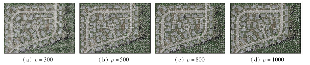
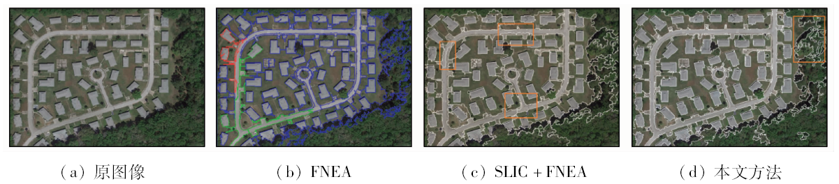
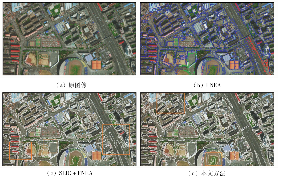
在面向对象多光谱图像分割方法中,初始对象特征往往无法反映真实区域的整体特征,从而产生错误的合并结果。针对以上问题,提出采用简单线性迭代聚类(simple linear iterative clustering, SLIC)超像素与结构张量粗分割相结合的方法对其进行改进。先采用SLIC超像素方法产生初始过分割结果,用结构张量产生尺度空间下的粗分割结果,再用粗分割结果指导超像素进行初步合并,使分形网络演化方法(fractal net evolution approach,FNEA)所面向的初始对象能够表达该区域的整体特征,增强后续合并过程对噪声的抗性。将该方法与传统FNEA的分割结果对比表明,该方法具有良好的抗噪能力,对复杂城区高空间分辨率多光谱图像能够得到较好的分割结果。

服务
把本文推荐给朋友
加入引用管理器
E-mail Alert
RSS
作者相关文章
张永梅
孙海燕
胥玉龙
关键词 超像素多光谱图像图像分割分形网络演化    
Abstract

In the object-oriented multispectral image segmentation, the initial object feature may not reflect the global feature of the whole region and can lead to an incorrect merge. To solve the problem, this paper proposes a method that combines the result of the simple linear iterative clustering(SLIC) super pixel and the rough segmentation result of structure tensor. First, the SLIC process is executed to get an over-segmentation result. Then, make sure the feature of the initial object of the fractal net evolution approach can reflect the real distribution of the whole region, and do the pre-merging between the super pixels under the control of the rough segmentation result of the structure tensor in the scale space. This process can enhance the anti-noise capability of the following merging process. Finally, the final results are given; compared with the results of the traditional fractal net evolution approach(FNEA), the result shows that the method proposed in the paper has better anti-noise capability, and can get better segmentation results even in handling the complex city multispectral images.

Key wordssuper pixel    multispectral image    image segmentation    fractal net evolution approach
收稿日期: 2018-01-02      出版日期: 2019-03-15
:  TP751.1  
基金资助:国家自然科学基金项目“多源遥感图像识别关键技术研究”(61371143);北方工业大学学科建设项目“计算机科学与技术优势学科”共同资助(XN044)
作者简介: 张永梅(1967-),女,博士,教授,研究方向为图像处理。Email: zhangym@ncut.edu.cn。
引用本文:   
张永梅, 孙海燕, 胥玉龙. 一种改进的基于超像素的多光谱图像分割方法[J]. 国土资源遥感, 2019, 31(1): 58-64.
Yongmei ZHANG, Haiyan SUN, Yulong XU. An improved multispectral image segmentation method based on super-pixels. Remote Sensing for Land & Resources, 2019, 31(1): 58-64.
链接本文:  
https://www.gtzyyg.com/CN/10.6046/gtzyyg.2019.01.08      或      https://www.gtzyyg.com/CN/Y2019/V31/I1/58
Fig.1  p分别为300,500,800和1000像素的超像素分割结果
Fig.2  p=300条件下预合并结果
Fig.3  实验1分割结果
Fig.4  实验1目视解译结果
FNEA SLIC+FNEA 本文方法
Kappa 0.543 1 0.694 4 0.724 1
OCE 0.672 5 0.451 3 0.321 0
Tab.1  实验1定量分析结果
Fig.5  实验2分割结果
Fig.6  实验2道路提取结果
FNEA SLIC+FNEA 本文方法
准确率 0.850 1 0.849 5 0.851 8
遗漏率 0.149 9 0.150 5 0.147 2
错分率 0.382 2 0.543 8 0.420 5
Tab.2  实验2定量分析结果
[1] 马燕妮, 明冬萍, 杨海平 . 面向对象影像多尺度分割最大异质性参数估计[J]. 遥感学报, 2017,21(4):566-578.
doi: 10.11834/jrs.20176374
Ma Y N, Ming D P, Yang H P . Scale estimation of object-oriented image analysis based on spectral-spatial statistics[J]. Journal of Remote Sensing, 2017,21(4):566-578.
[2] 黄亮, 左小清, 冯冲 , 等. 基于Canny算法的面向对象影像分割[J]. 国土资源遥感, 2011,23(4):26-30.doi: 10.6046/gtzyyg.2011.04.05.
doi: 10.6046/gtzyyg.2011.04.05
Huang L, Zuo X Q, Feng C , et al. Object-oriented image segmentation based on Canny algorithm[J]. Remote Sensing for Land and Resources, 2011,23(4):26-30.doi: 10.6046/gtzyyg.2011.04.05.
[3] 贾春阳, 李卫华, 李小春 . 基于自适应权值FNEA算法的高分辨率遥感图像分割[J]. 国土资源遥感, 2013,25(4):22-25.doi: 10.6046/gtzyyg.2013.04.04.
doi: 10.6046/gtzyyg.2013.04.04
Jia C Y, Li W H, Li X C . High-resolution remote sensing image segmentation based on weight adaptive fractal net evolution approach[J]. Remote Sensing for Land and Resources, 2013,25(4):22-25.doi: 10.6046/gtzyyg.2013.04.04.
[4] Peng P, Gao W, Liu X G, et al. An improved strategy for object-oriented multi-scale remote sensing imagesegmentation [C]//International Conference on Information Science and Engineering.IEEE, 2010: 1149-1152.
[5] 邓富亮, 范协裕, 王刚 , 等. 一种FNEA影像分割算法中初始对象的快速构建方法[J]. 中国科学院大学学报, 2014,31(4):484-491.
doi: 10.7523/j.issn.2095-6134.2014.04.007
Deng F L, Fan X Y, Wang G , et al. A fast method for creation of the initial objects for FNEA image segmentation[J]. Journal of University of Chinese Academy of Sciences, 2014,31(4):484-491.
[6] 张勇, 袁家政, 刘宏哲 , 等. 基于结构张量的GrabCut图像分割算法[J]. 计算机工程, 2017,43(8):258-265,271.
doi: 10.3969/j.issn.1000-3428.2017.08.044
Zhang Y, Yuan J Z, Liu H Z , et al. GrabCut image segmentation algorithm based on structure tensor[J]. Computer Engineering, 2017,43(8):258-265,271.
[7] 董志鹏, 王密, 李德仁 . 一种融合超像素与最小生成树的高分辨率遥感影像分割方法[J]. 测绘学报, 2017,46(6):734-742.
Dong Z P, Wang M, Li D R . A high resolution remote sensing image segmentation method by combining superpixels with minimum spanning tree[J]. Acta Geodaeticaet Cartographica Sinica, 2017,46(6):734-742.
[8] Achanta R, Shaji A, Smith K , et al. SLIC superpixels[EB/OL].
[9] Achanta R, Shaji A, Smith K , et al. SLIC superpixels compared to state-of-the-art superpixel methods[J]. IEEE Transactions on Pattern Analysis and Machine Intelligence, 2012,34(11):2274-2282.
doi: 10.1109/TPAMI.2012.120 pmid: 22641706
[10] Shi J B, Malik J . Normalized cuts and image segmentation[J]. IEEE Transactions on Pattern Analysis and Machine Intelligence, 2000,22(8):888-905.
doi: 10.1109/34.868688
[11] Veksler O, Boykov Y, Mehrani P. Superpixels and supervoxels in an energy optimization framework [C]//European Conference on Computer Vision, 2010: 211-224.
[12] Levinshtein A, Stere A, Kutulakos K N , et al. TurboPixels:Fast superpixels using geometric flows[J]. IEEE Transactions on Pattern Analysis and Machine Intelligence, 2009,31(12):2290-2297.
doi: 10.1109/TPAMI.2009.96 pmid: 19834148
[13] Vedaldi A, Soatto S. Quick shift and kernel methods for mode seeking [C]//European Conference on Computer Vision. 2008: 705-718.
[14] 闵永智, 程天栋, 殷超 , 等. 基于GLCM与自适应Gabor滤波器组的纹理图像分割[J]. 计算机工程, 2017,43(1):280-286.
doi: 10.3969/j.issn.1000-3428.2017.01.048
Min Y Z, Cheng T D, Yin C , et al. Texture image segmentation based on GLCM and self-adaptive Gabor filter bank[J]. Computer Engineering, 2017,43(1):280-286.
[15] 崔兆华, 李洪军, 李文娜 , 等. 基于自适应结构张量的FCM改进算法[J]. 东北大学学报(自然科学版), 2013,34(5):637-641.
Cui Z H, Li H J, Li W N , et al. An improved FCM algorithm based on adaptive structure tensor[J]. Journal of Northeastern University (Natural Science), 2013,34(5):637-641.
[16] 李梦 . 图像分割的结构张量几何活动轮廓模型[J]. 计算机应用研究, 2014,31(12):3890-3893.
doi: 10.3969/j.issn.1001-3695.2014.12.095
Li M . Geometric active contours based on structure tensor for image segmentation[J]. Application Research of Computers, 2014,31(12):3890-3893.
[17] 周绍光, 陈超, 岳建平 . 形状先验和图割的高分辨率遥感影像道路段提取[J]. 测绘学报, 2014,43(1):60-65.
doi: 10.13485/j.cnki.11-2089.2014.0009
Zhou S G, Chen C, Yue J P . Extracting roads from high-resolution rs image based on shape priors and GraphCuts[J]. Acta Geodaetica et Cartographica Sinica, 2014,43(1):60-65.
[1] 张大明, 张学勇, 李璐, 刘华勇. 一种超像素上Parzen窗密度估计的遥感图像分割方法[J]. 自然资源遥感, 2022, 34(1): 53-60.
[2] 王华, 李卫卫, 李志刚, 陈学业, 孙乐. 基于多尺度超像素的高光谱图像分类研究[J]. 自然资源遥感, 2021, 33(3): 63-71.
[3] 夏炎, 黄亮, 陈朋弟. 模糊超像素分割算法的无人机影像烟株精细提取[J]. 国土资源遥感, 2021, 33(1): 115-122.
[4] 张锐, 尤淑撑, 杜磊, 禄競, 何芸, 胡勇. 基于改进超像素和标记分水岭的高分辨率遥感影像分割方法[J]. 国土资源遥感, 2021, 33(1): 86-95.
[5] 王碧晴, 韩文泉, 许驰. 基于图像分割和NDVI时间序列曲线分类模型的冬小麦种植区域识别与提取[J]. 国土资源遥感, 2020, 32(2): 219-225.
[6] 姚丙秀, 黄亮, 许艳松. 一种结合超像素和图论的高空间分辨率遥感影像分割方法[J]. 国土资源遥感, 2019, 31(3): 72-79.
[7] 吴柳青, 胡翔云. 基于多尺度多特征的高空间分辨率遥感影像建筑物自动化检测[J]. 国土资源遥感, 2019, 31(1): 71-78.
[8] 苏腾飞, 张圣微, 李洪玉. 基于超像素MRF的农田地区高分遥感影像分割[J]. 国土资源遥感, 2018, 30(1): 37-44.
[9] 赵庆平. 朗伯定律的宽观测带SAR海冰图像分割[J]. 国土资源遥感, 2017, 29(2): 67-71.
[10] 滑永春, 李增元, 高志海, 郭中. 基于GF-2民勤县白刺包提取技术[J]. 国土资源遥感, 2017, 29(1): 71-77.
[11] 张涛, 杨晓梅, 童立强, 贺鹏. 基于多尺度图像库的遥感影像分割参数优选方法[J]. 国土资源遥感, 2016, 28(4): 59-63.
[12] 苏腾飞, 李洪玉, 屈忠义. 高分辨率遥感图像道路分割算法[J]. 国土资源遥感, 2015, 27(3): 1-6.
[13] 李莎, 倪维平, 严卫东, 吴俊政, 张晗. 基于选权迭代估计与非监督分类的多光谱图像变化检测[J]. 国土资源遥感, 2014, 26(4): 34-40.
[14] 贾春阳, 李卫华, 李小春. 基于自适应权值FNEA算法的高分辨率遥感图像分割[J]. 国土资源遥感, 2013, 25(4): 22-25.
[15] 徐宏根, 宋妍. 顾及阴影信息的高分辨率遥感图像变化检测方法[J]. 国土资源遥感, 2013, 25(4): 16-21.
Viewed
Full text


Abstract

Cited

  Shared   
  Discussed   
京ICP备05055290号-2
版权所有 © 2015 《自然资源遥感》编辑部
地址:北京学院路31号中国国土资源航空物探遥感中心 邮编:100083
电话:010-62060291/62060292 E-mail:zrzyyg@163.com
本系统由北京玛格泰克科技发展有限公司设计开发