1.Xi’an Peihua University, School of Accounting and Finance, Xi’an 710065, China; 2.Rocket Force Engineering University, School of Nuclear Engineering, Xi’an 710025, China; 3.Troops No.96862, Luoyang 471003, China
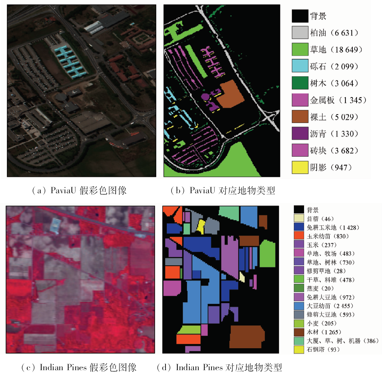
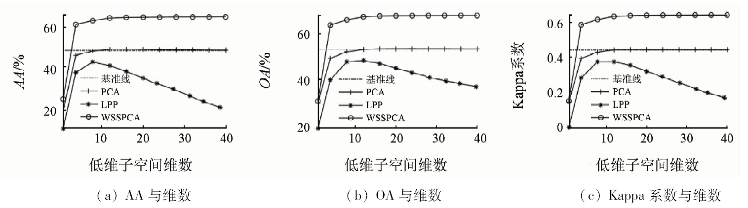
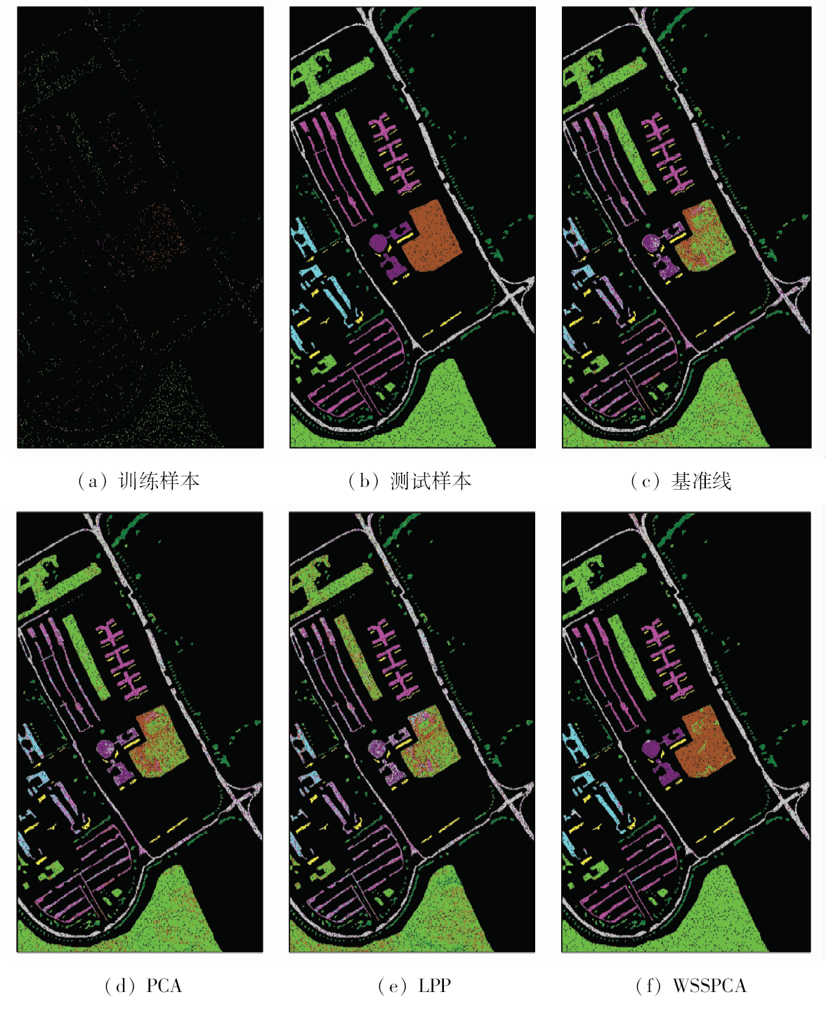
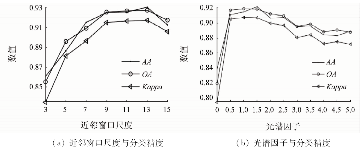
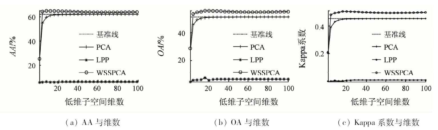
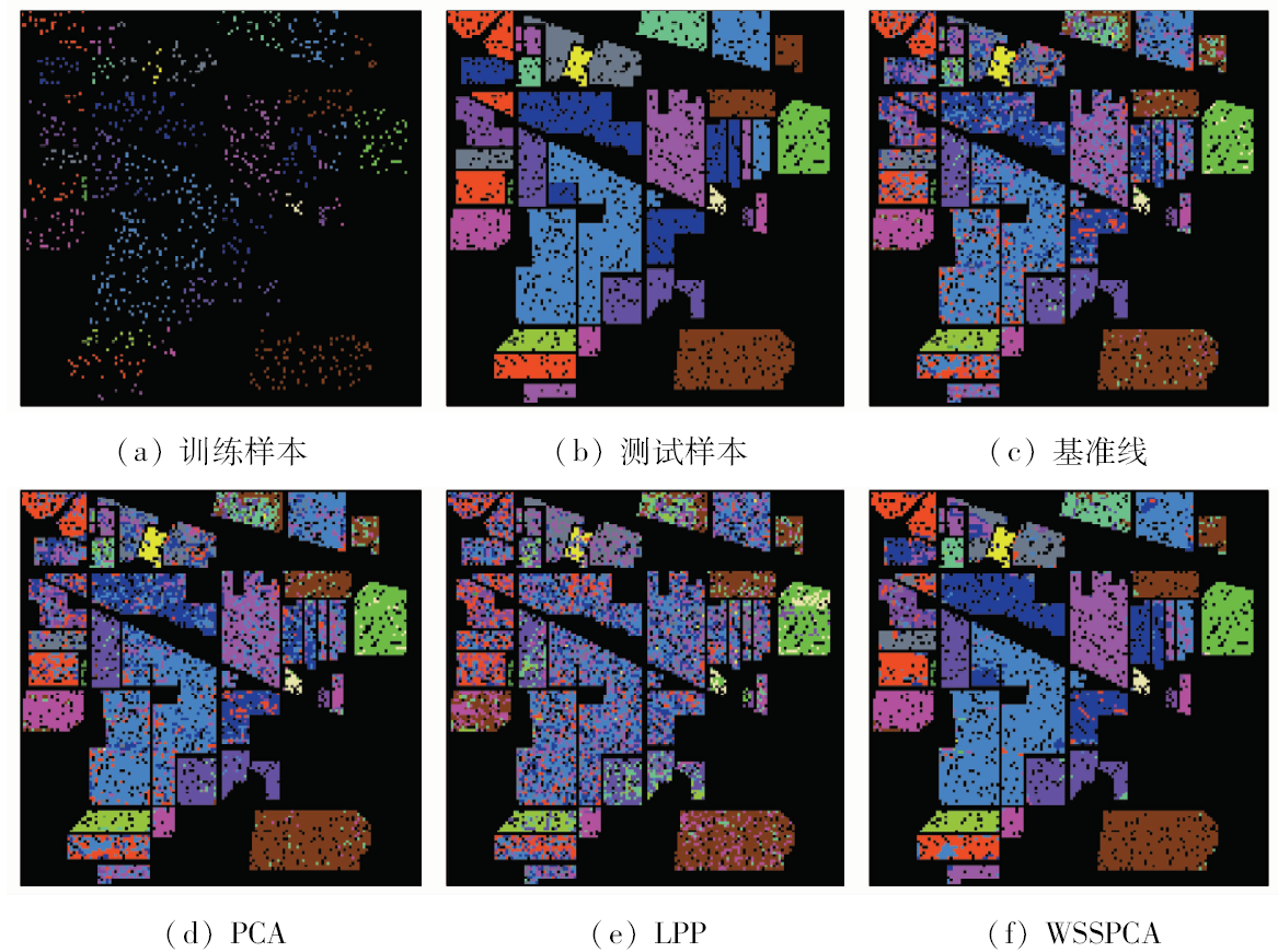
In order to improve the hyperspectral images (HSI) classification accuracy and preprocess HSI by fully using the spatial and spectral information, this paper proposes a new spatial-spectral dimensionality reduction method, i.e., weighted spatial and spectral principle component analysis (WSSPCA). This algorithm reconstructs the HSI by using the physical characteristics of HSI, which can lower the influence of singular point in HSI. Principle component analysis (PCA) is utilized to reduce dimensionality of HIS, and it reduces the redundancy between bands and improves the HSI classification accuracy efficiently. The benchmark tests on PaviaU and Indian Pines demonstrate that the performance of WSSPCA is better than that of PCA and LPP when 5% and 10% samples in each class (10 samples are chosen when the total samples in every class is less than 100) are chosen randomly as train samples. The best values of Kappa coefficient obtained by WSSPCA are 0.955 9 and 0.896 1 respectively on the HSI datasets, exceeding the baseline by 0.193 8 and 0.205 0.
Huang H, Yang M, Zhang M J . Hyperspectral remote sensing image classification based on SDE[J]. Optics and Precision Engineering, 2013,21(11):2922-2930.
Yang Y, Han C Z, Han D Q . Hyperspectral image classification based on feature subspace evaluation and multiple classification fusion[J]. Journal of Xi’an Jiaotong University, 2010,44(8):21-24.
Nian Y J, Su L H, Sun L , et al. Lossless coding for hyperspectral image based on spectral cluster[J]. Journal of Electronics and Information Technology, 2009,31(6):1271-1274.
Chang W W, Guo L, Liu K , et al. Denoising of hyperspectral data based on Contourlet transform and principal component analysis[J]. Journal of Electronics and Information Technology, 2009,31(12):2892-2896.
Liu J M, Luo F L, Huang H , et al. Classification of hyperspectral remote sensing images using correlation neighbor LLE[J]. Optics and Precision Engineering, 2014,22(6):1668-1676.
[6]
何同弟 . 高光谱图像的分类技术研究[D]. 重庆:重庆大学, 2014.
He T D . The Classification Technology Research Based on Hyperspectral Image[D]. Chongqing:Chongqing University, 2014.
Pan Z X, Yu J, Xiao C B , et al. Spectral similarity-based super resolution for hyperspectral images[J]. Acta Automatica Sinica, 2014,40(12):2797-2807.
[8]
Zhou Y C, Peng J T , Chen C L P .Dimension reduction using spatial and spectral regularized local discriminant embedding for hyperspectral image classification[J]. IEEE Transactions on Geoscience and Remote Sensing, 2015,53(2):1082-1095.
doi: 10.1109/TGRS.2014.2333539
Tang Z Q, Fu G Y, Chen J , et al. Multiscale segmentation-based sparse coding for hyperspectral image classification[J]. Optics and Precision Engineering, 2015,23(9):2708-2714.
[10]
He R, Hu B G, Zheng W S , et al. Robust principal component analysis based on maximum correntropy criterion[J]. IEEE Transactions on Image Processing, 2011,20(6):1485-1494.
doi: 10.1109/TIP.2010.2103949
[11]
Zhou Y C, Peng J T , Chen C L P .Dimension reduction using spatial and spectral regularized local discriminant embedding for hyperspectral image classification[J]. IEEE Transactions on Geoscience and Remote Sensing, 2015,53(2):1082-1095.
doi: 10.1109/TGRS.2014.2333539
[12]
金鹏磊 . 空-谱联合高光谱数据降维与分类方法研究[D]. 西安:西安电子科技大学, 2014.
Jing P L . Researches on Spatial-Spectral Based Dimensionality Reduction and Classification of Hypespectral Data[D]. Xi’an:Xidian University, 2014
[13]
Bandos T V, Bruzzone L , Camps-Valls . Classification of hyperspectral image with regularized linear discriminant analysis[J]. IEEE Transactions on Geoscience and Remote Sensing, 2009,47(3):862-873.
doi: 10.1109/TGRS.2008.2005729
[14]
Wang R, Nie F P, Yang X J , et al. Robust 2DPCA with non-greedy -norm maximization for image analysis[J]. IEEE Transactions on Cybernetics, 2015,45(5):1108-1112.
[15]
Lu X, Li X . Multiresolution imaging[J]. IEEE Transactions on Cybernetics, 2014,44(1):149-160.
doi: 10.1109/TCYB.2013.2286496
[16]
He X F, Niyogi P. Locality preserving projections [C]//Advances in Neural Information Processing Systems(NIPS).Vancouver:MIT, 2004,16:153-160.
[17]
Zhang Z Y, Zha H Y . Principal manifolds and nonlinear dimensionality reduction via local tangent space alignment[J]. Journal of Shanghai University, 2004,8(4):406-424
doi: 10.1007/s11741-004-0051-1
Huang H, Zheng X L . Hyperspectral image classification with combination of weighted spatial-spectral and KNN[J]. Optics and Precision Engineering, 2016,24(4):873-881.
He F, Wang R, Yu Q , et al. Feature extraction of hyperspectral images of weighted spatial and spectral locality preserving projection (WSSLPP)[J]. Optics and Precision Engineering, 2017,25(1):263-273.
[20]
Huang H, Luo F L, Liu J M , et al. Dimensionality reduction of hyperspectral images based on sparse discriminant manifold embedding[J]. ISPRS Journal of Photogrammetry and Remote Sensing, 2015,106:42-54.
doi: 10.1016/j.isprsjprs.2015.04.015
 2019, Vol. 31