National Key Laboratory of Remote Sensing Information and Image Analyzing Technology, Beijing Research Institute of Uranium Geology, Beijing 100029, China
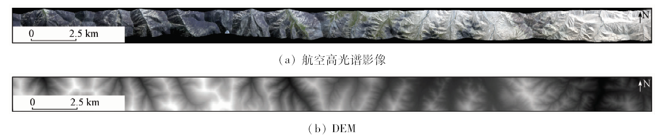
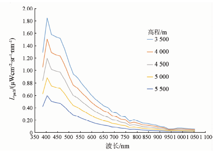
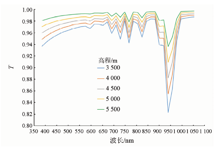
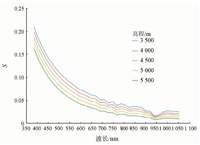
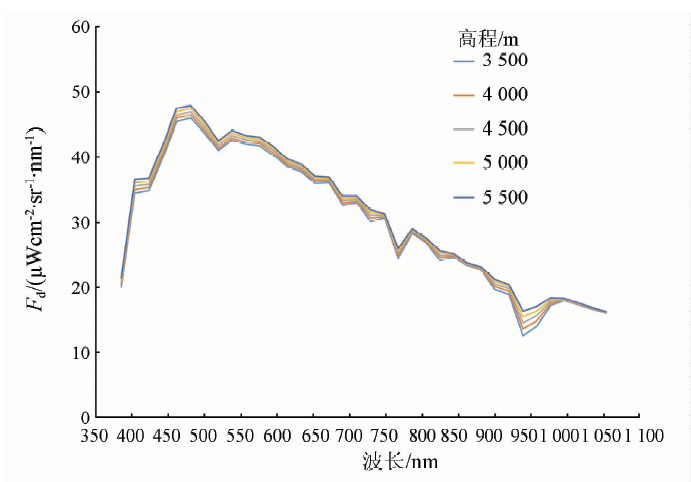
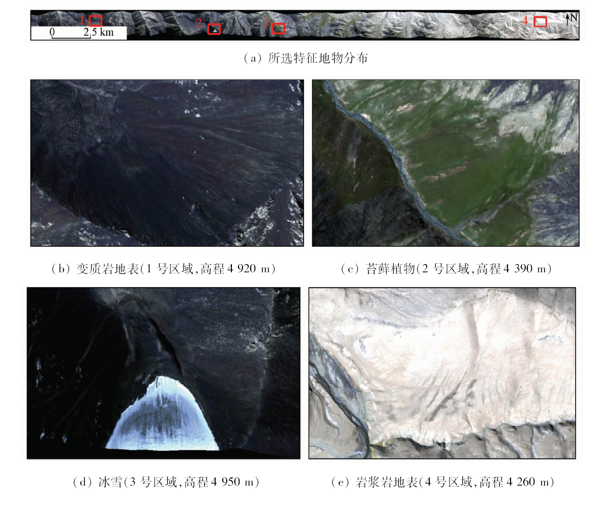
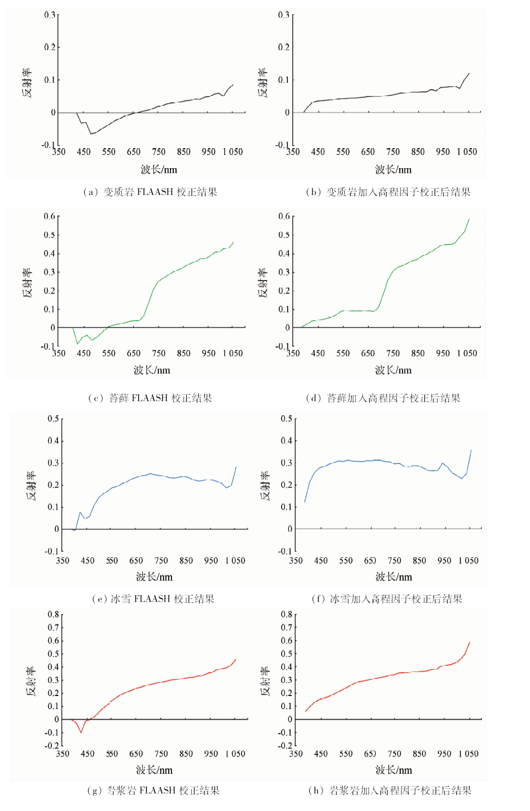
Topographic effect is one of the main obstacles in quantitative analysis of remote sensing. For the airborne hyperspectral remote sensing, both of the impact of terrain height and angle can’t be ignored, and this causes more severe topographic effects. By taking the CASI image and LiDAR data of Qinghai Province as experimental data, the impact of elevation factor was analyzed in this paper. Firstly, on the premise that each elevation point is a horizontal Lambert body, four different elevation values were taken as reference to calculate the corresponding atmospheric radiation correction parameters by performing MODTRAN, which contain path radiance,atmospheric transmittance between the object and the sensor, atmospheric hemisphere albedo, and total downward radiance. Then an atmospheric radiation correction method with elevation factor was designed and applied to the atmospheric correction of CASI image. Finally, the CASI hyperspectral image was also processed by using FLAASH, which could only take one elevation value as reference. A comparison of two results shows that the reflectance spectrum shapes of the same ground objects are roughly the same,but the reflectance values are different. Especially, the short-wavelength reflectance values of FLAASH results are negative, and it is undoubtedly wrong. The experiment shows that the impact of elevation factors can’t be neglected. Atmospheric correction by adding elevation factors can get better results. For achieving accurate topographic correction of airborne hyperspectral image, both elevation and topographic angle factors should be considered simultaneously.
Schaaf C, Li X, Strahler A . Topographic effects on bidirectional and hemispherical reflectances calculated with a geometric-optical canopy model[J]. IEEE Transactions on Geoscience and Remote Sensing, 1994,32(6):1186-1193.
doi: 10.1109/36.338367
[2]
Oliphant A J , Spronken-Smith R A,Sturman A P ,et al.Spatial variability of surface radiation fluxes in mountainous terrain[J]. Journal of Applied Meteorology, 2003,42(1):113-128.
doi: 10.1175/1520-0450(2003)042<0113:SVOSRF>2.0.CO;2
[3]
Wen J G, Zhao X J, Liu Q , et al. An improved land-surface albedo algorithm with DEM in rugged terrain[J]. IEEE Geoscience and Remote Sensing Letters, 2014,11(4):883-887.
doi: 10.1109/LGRS.2013.2280696
Li A N, Bian J H, Zhang Z J , et al. Progresses,opportunities,and challenges of mountain remote sensing research[J]. Journal of Remote Sensing, 2016,20(5):1199-1215.
[5]
宫鹏 . 遥感科学与技术中的一些前沿问题[J]. 遥感学报, 2009,13(1):13-23.
Gong P . Some essential questions in remote sensing science and technology[J]. Journal of Remote Sensing, 2009,13(1):13-23.
Wang S N, Li A N . The progress in the study of topographic radiometric correction models[J]. Remote Sensing for Land and Resources, 2012,24(2):1-6.doi: 10.6046/gtzyyg.2012.02.01.
Huang B, Xu L H . Applied research of topographic correction based on the improved Minnaert model[J]. Remote Sensing Technology and Application, 2012,27(2):183-189.
[8]
Lu D S, Ge H L, He S Z , et al. Pixel-based Minnaert correction method for reducing topographic effects on a Landsat 7 ETM+ image[J]. Photogrammetric Engineering and Remote Sensing, 2008,74(11):1343-1350.
doi: 10.14358/PERS.74.11.1343
[9]
Wen J G, Liu Q H, Liu Q , et al. Parametrized BRDF for atmospheric and topographic correction and albedo estimation in Jiangxi rugged terrain,China[J]. International Journal of Remote Sensing, 2009,30(11):2875-2896.
doi: 10.1080/01431160802558618
[10]
Li A N, Wang Q F, Bian J H , et al. An improved physics-based model for topographic correction of Landsat TM images[J]. Remote Sensing, 2015,7(5):6296-6319.
doi: 10.3390/rs70506296
[11]
Richter R, Kellenberger T, Kaufmann H . Comparison of topographic correction methods[J]. Remote Sensing, 2009,1(3):184-196.
doi: 10.3390/rs1030184
[12]
Hantson S, Chuvieco E . Evaluation of different topographic correction methods for Landsat imagery[J]. International Journal of Applied Earth Observation and Geoinformation, 2011,13(5):691-700.
doi: 10.1016/j.jag.2011.05.001
[13]
Balthazar V, Vanacker V, Lambin E F . Evaluation and parameterization of ATCOR3 topographic correction method for forest cover mapping in mountain areas[J]. International Journal of Applied Earth Observation and Geoinformation, 2012,18(1):436-450.
doi: 10.1016/j.jag.2012.03.010
Tong Q X, Zhang B, Zheng L F. Hyperspectral Remote Sensing:Principle,Technology and Applications[M]. Beijing: Higher Education Press, 2006: 86-105.
[15]
Adler-Golden S M, Matthew M W, Bernstein L S , et al. Atmospheric correction for short-wave spectral imagery based on MODTRAN4[J]. Proceedings of SPIE,the International Society for Optical Engineering, 1999,3753:61-69.
[16]
Kaufman Y J . Atmospheric effect on spectral signature-measurements and corrections[J]. IEEE Transactions on Geoscience and Remote Sensing, 1988,26(4):441-450.
doi: 10.1109/36.3048
[17]
Anderson G P, Felde G W, Hoke M L , et al. MODTRAN4-based atmospheric correction algorithm:FLAASH (fast line-of-sight atmospheric analysis of spectral hypercubes)[J]. Proceedings of SPIE,the International Society for Optical Engineering, 2002,4725:65-71.
 2019, Vol. 31