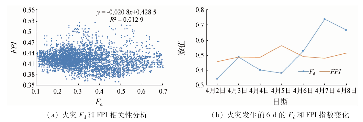
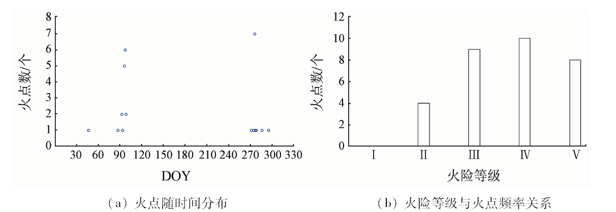
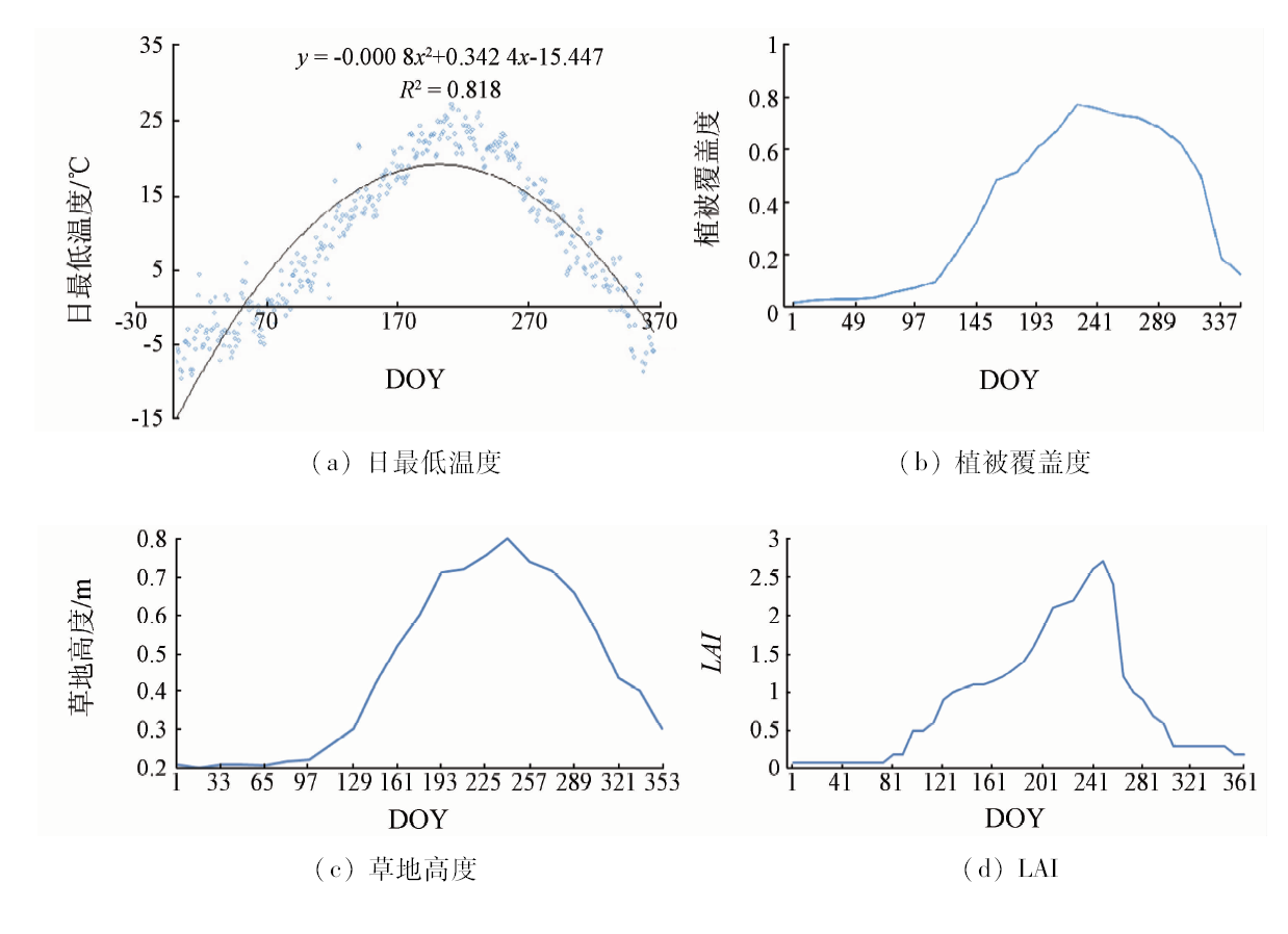
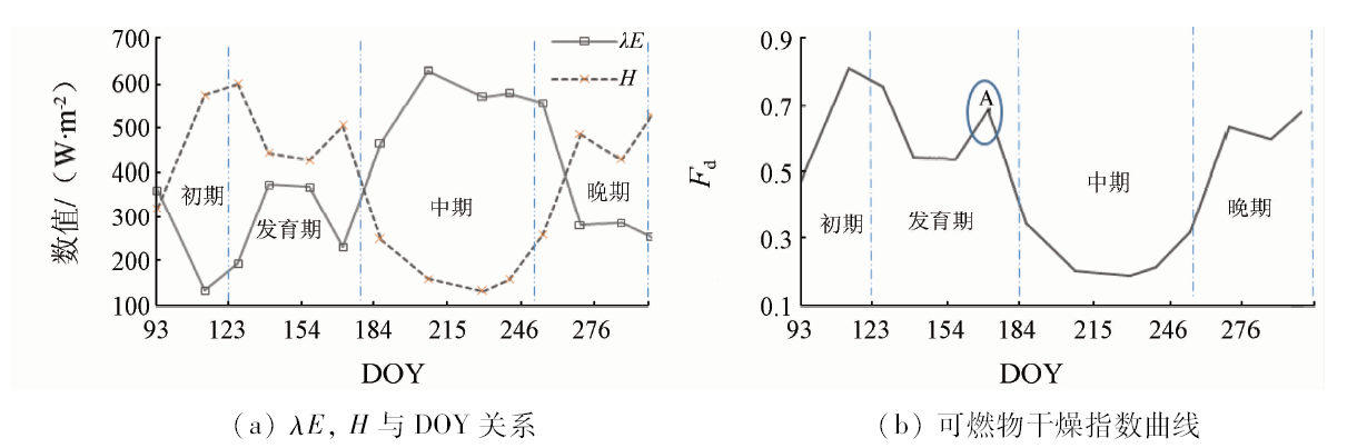
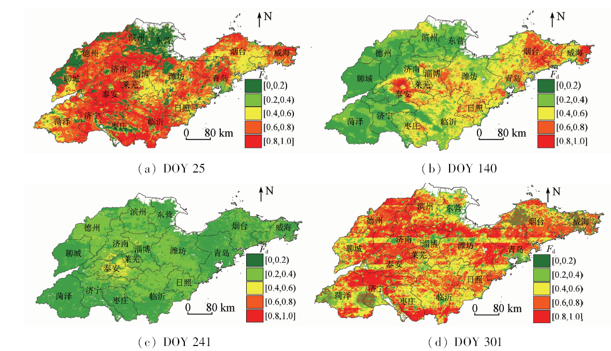
In this paper, on the basis of prairie biophysical characteristics and in combination with the principle of energy exchange (sensible heat and latent heat flux obtained by remote sensing and meteorological data), the fuel dry index (Fd) was proposed and applied to the Shandong prairie fire monitoring. Fd can better solve the prairie fire forecast, fire danger early warning in time and space and the estimation accuracy. It can change dynamic warning daily high fire risk areas with time in Shandong Province. Fd and fire potential index (FPI) were used to study the fire danger on April 8, 2010. Fire indicating effect of Fd is better than that of FPI. In the equidistance fire classification, data of 31 fire points in 2010 indicated by Fd fell in grade III, accounting for 87.1%, and 0 fell in grade I; the fire locations were in good agreement with areas of high fire risk early warning. In fuel dry index (Fd) graph, it can be seen that Fd has close relationship with the prairie vegetation growing season; the early development of Fd is high, but later it exhibits decreasing trend; at the medium stage, Fd is low; at the late stage,Fd is high, and shows a trend of rising. Overall, the Fd index plays an important role in fire danger forecast at the grassland growing stage.
黄宝华. 可燃物干燥指数在草地火险预警中的应用[J]. 国土资源遥感, 2019, 31(2): 187-195.
Baohua HUANG. Application of fuel dry index in the prairie fire danger. Remote Sensing for Land & Resources, 2019, 31(2): 187-195.
Smith B , McDermid G J .Examination of fire-related succession within the dry mixed-grass subregion of Alberta with the use of MODIS and Landsat[J]. Rangeland Ecology and Management, 2014,67(3):307-317.
doi: 10.2111/REM-D-13-00078.1
Huang B H, Zhang H, Zhou L X . Research on application of integrated fire danger index based on ignition and fire[J]. China Safety Science Journal, 2013,23(8):37-42.
Huang B H, Sun Z J, Zhang H , et al. Research on the evaluation method of potential forest fire:Taking Shandong Provience as an example[J]. Journal of Catastrophology, 2014,29(4):116-121.
[4]
Agee J K, Wright C S, Williamson N , et al. Foliar moisture content of Pacific Northwest vegetation and its relation to wildland fire behavior[J]. Forest Ecology and Management, 2002,167(1-3):57-66.
doi: 10.1016/S0378-1127(01)00690-9
[5]
Zarco-Tejada P J, Rueda C A, Ustin S L . Water content estimation in vegetation with MODIS reflectance data and model inversion methods[J]. Remote Sensing of Environment, 2003,85(1):109-124.
doi: 10.1016/S0034-4257(02)00197-9
[6]
Huesca M, Litago J, Palacios-Orueta A , et al. Assessment of forest fire seasonality using MODIS fire potential:A time series approach[J]. Agricultural and Forest Meteorology, 2009,149(11):1946-1955.
doi: 10.1016/j.agrformet.2009.06.022
[7]
Dasgupta S, Qu J J, Hao X , et al. Evaluating remotely sensed live fuel moisture estimations for fire behavior predictions in Georgia,USA[J]. Remote Sensing of Environment, 2007,108(2):138-150.
doi: 10.1016/j.rse.2006.06.023
[8]
Dennison P E, Moritz M A, Taylor R S . Evaluating predictive models of critical live fuel moisture in the Santa Monica Mountains,California[J]. International Journal of Wildland Fire, 2008,17(1):18-27.
doi: 10.1071/WF07017
[9]
Chuvieco E, González I, Verdú F , et al. Prediction of fire occurrence from live fuel moisture content measurements in a Mediterranean ecosystem[J]. International Journal of Wildland Fire, 2009,18(4):430-441.
doi: 10.1071/WF08020
[10]
Dennison P E, Roberts D A, Thorgusen S R , et al. Modeling seasonal changes in live fuel moisture and equivalent water thickness using a cumulative water balance index[J]. Remote Sensing of Environment, 2003,88(4):442-452.
doi: 10.1016/j.rse.2003.08.015
[11]
Chowdhury E H, Hassan Q K . Operational perspective of remote sensing-based forest fire danger forecasting systems[J]. ISPRS Journal of Photogrammetry and Remote Sensing, 2015,104:224-236.
doi: 10.1016/j.isprsjprs.2014.03.011
[12]
Snyder R L, Spano D, Duce P , et al. A fuel dryness index for grassland fire-danger assessment[J]. Agricultural and Forest Meteoro-logy, 2006,139(1-2):1-11.
doi: 10.1016/j.agrformet.2006.05.006
[13]
田国良 . 热红外遥感[M]. 北京: 电子工业出版社, 2006: 302-304.
Tian G L. Thermal Remote Sensing[M]. Beijing: Publishing House of Electronics Industry, 2006: 302-304.
Wang D, Zhang L Q, Xue J H . A review about physiological and molecular responses to drought stress of forest tree[J]. Journal of Anhui Agricultural Sciences, 2011,39(25):15426-15431.
Zhang C, Yan H F, Oue H , et al. Parameterization of surface soil available moisture and simulation of soil evaporation beneath canopy[J].Transaction of the Chinese Society of Agricultural Engineering, 2015(2):102-107.
[16]
Van de Griend A, Owe M . On the relationship between thermal emissivity and the normalized difference vegetation index for natural surfaces[J]. International Journal of Remote Sensing, 1993,14(6):1119-1131.
doi: 10.1080/01431169308904400
Sun M Z, Liu Z X, Lyu M C , et al. The study of monitoring ET by SEBEL and its application in water resource management of Hai River Basin[J]. Journal of irrigation and orainage, 2005,24(3):74-76.
Zeng L H, Song K S, Zhang B , et al. Applying Landsat data and SEBAL model to inverse regional evapotranspiration and its parameters estimation[J]. Remote Sensing Technology and Application, 2008,23(3):255-263.
[19]
Allen R G, Pereira L S, Raes D , et al. Crop Evapotranspiration-Guidelines for Computing Crop Water Requirements[M]. Italy:Food and Agriculture Organization of the United Nations Rome, 1998.
[20]
Lagouarde J P, Brunet Y . Spatial integration of surface latent heat flux and evaporation mapping[J]. Advances in Space Research. 1989,9(7):259-264.
[21]
Su Z, Jacobs C . ENVISAT:Actual Evaporation[R]. Delft:Beleidscommissie Remote Sensing, 2001.
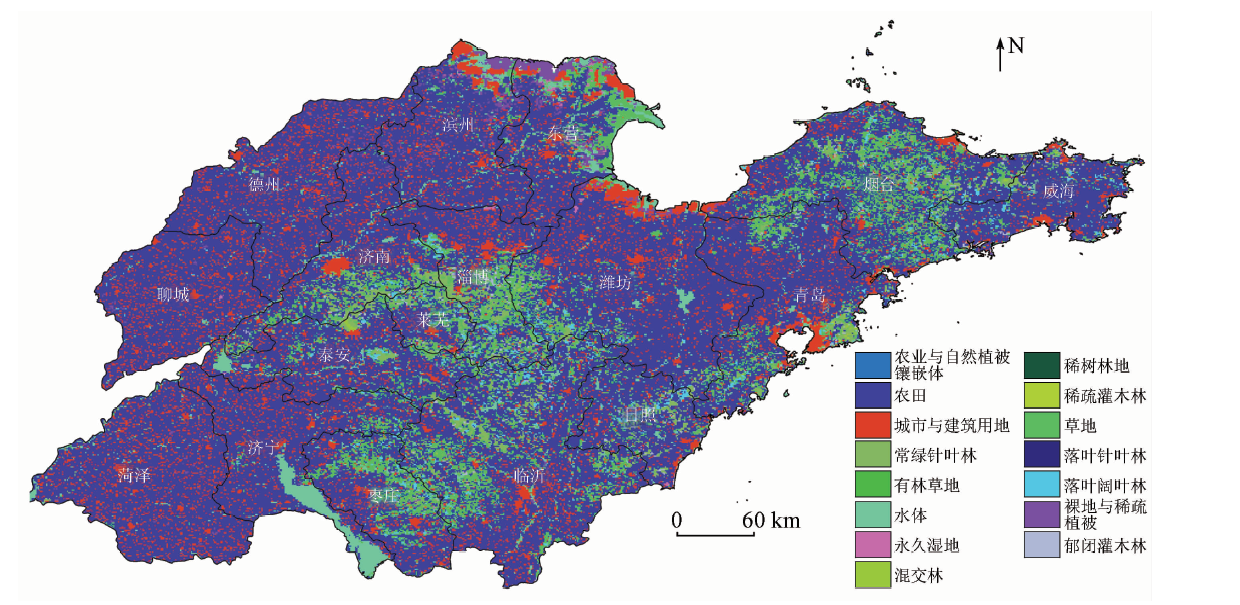
Tian G Q, Zhang M C . The remote sensing monitoring of ecological environment in Shandong Province[J]. Remote Sensing for Land and Resources, 2006,18(4):63-67.doi: 10.6046/gtzyyg.2006.04.16.
Ran Y H, Li X, Lu L . China land cover classification at 1 km spatial resolution based on a multi-source data fusion approach[J]. Advances in Earth Science, 2009,24(2):192-203.
 2019, Vol. 31