Fusion algorithm evaluation of Landsat 8 panchromatic and multispetral images in arid regions
Liping YANG1, Meng MA2, Wei XIE2, Xueping PAN2
1. School of Geological Engineering and Geomatics, Chang’an University, Xi’an 710054, China; 2. School of Earth Sciences and Resources, Chang’an University, Xi’an 710054, China;
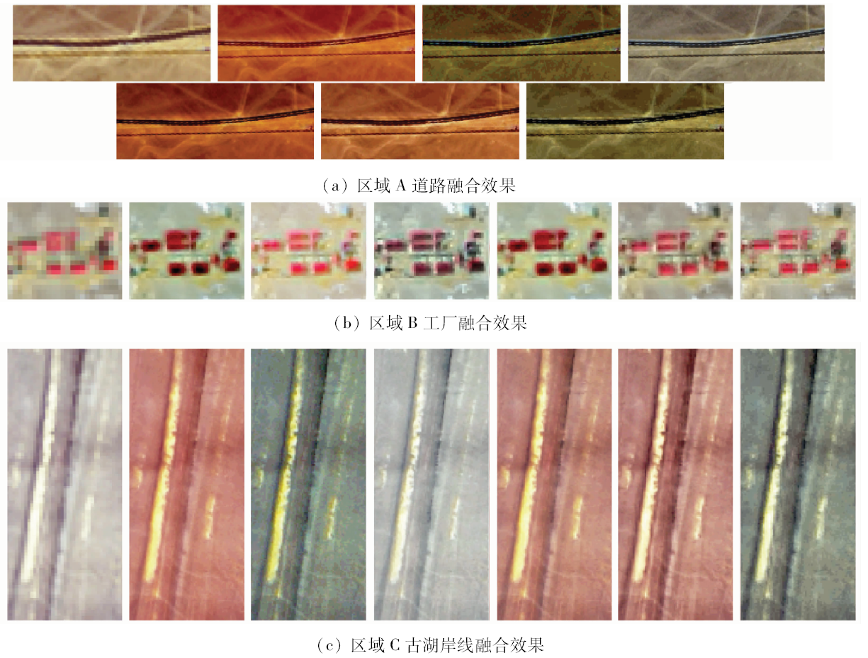
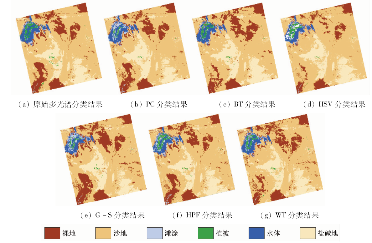
With lower contrast and confidence level, single factor evaluation index is not very effective in the comprehensive evaluation of pixel level image fusion algorithms of Landsat 8 in arid regions. Based on the Landsat 8 image of Juyanze area, 11 single factor indicators and object-oriented classification method were used to compare the following six image fusion algorithms, i.e., Principal Component (PC), Brovey Transform (BT), Hue-Saturation-Value Transform (HSV), Gram-Schmidt Pan Sharpening (G-S), High-pass filtering(HPF) and Wavelet Transform (WT) according to the spatial information quantity, spectral feature and classification accuracy. The results indicate that the spatial resolution and texture features of all fusion images are enhanced in comparison with the original image. HSV is proved to be the best algorithm to highlight the texture features in arid regions, but its spectral fidelity is bad. WT exhibits an excellent capability in maintaining the spectral information, and its capability of revealing spatial details is just next to the HSV method. Therefore, WT is considered the most suitable algorithm for image fusion of Landsat 8 in this study. Taking the spatial information quantity and spectral features into account simultaneously, the authors hold that PC and G-S have moderate performance, and their performance is a little lower than that of HPF, while the performance of BT is the worst. The classification results show that the classification accuracy of WT and HPF is improved to some extent compared with the original image.
Liu K, Fu J Y, Li F . Evaluation study of four fusion methods of GF-1 pan and multi-spectral images[J]. Remote Sensing Technology and Application, 2015,30(5):980-986.
Zheng Y L, Wang L G, Lu X . Comparison of image fusion methods for GF-2 panchromatic-multispectral[J]. Natural Science of Southwest Forestry University, 2018,38(2):103-111.
Xing Y J, Liu X N, Song Y B , et al. Research on fusion method comparison and analysis for domestic high resolution satellite images[J]. Journal of Central South University of Forestry and Technology, 2016,36(10):83-88.
Guo L, Yang Y H, Shi L S , et al. Comparative study of image fusion algorithms for SPOT6[J]. Remote Sensing for Land and Resources, 2014,26(4):71-77.doi: 10.6046/gtzyyg.2014.04.12.
Yang L P, Xia D S, Chen F H . On fusion algorithm of Landsat 7 ETM+ pan and multi-spectral images[J]. Natural Sciences of Lanzhou University, 2007,43(4):7-11.
Xie S Q, Zhao T Z, Wang W , et al. Study on fusion algorithms of GF-2 satellite image[J]. Journal of System Simulation, 2017,29(11):2742-2746.
[8]
Song H H, Huang B, Liu Q S , et al. Improving the spatial resolution of Landsat TM/ETM+ through fusion with Spot5 images via learning-based super-resolution[J]. IEEE Transactions on Geoscience and Remote Sensing, 2014,53(3):1195-1204.
Sun P, Dong Y S, Chen W T , et al. Research on fusion of GF-2 imagery and quality evaluation[J]. Remote Sensing for Land and Resources, 2016,28(4):108-113.doi: 10.6046/gtzyyg.2016.04.17.
Zhang B, Cui X M, Wei R , et al. Multi-data fusion in geological survey and mapping in plateau area based on RS and GIS[J]. Coal Engineering, 2016,48(3):99-102.
Ji Y J, Yue C R, Zhang W F . Use fusion of SAR and optical images for land cover classification[J]. Journal of Southwest Forestry University, 2016,36(3):158-162.
Gong J D, Cheng G D, Zhang X Y , et al. Environmental changes of Ejina region in the lower reaches of Heihe river[J]. Advance In Earth Sciences, 2002,17(4):491-496.
[13]
张玉君 . Landsat 8简介[J]. 国土资源遥感, 2013,25(1):176-177.
Zhang Y J . Introduction to Landsat 8[J]. Remote Sensing for Land and Resources, 2013,25(1):176-177.
[14]
Welch R . Merging multiresolution Spot HRV and Landsat TM data[J]. Photogrammetric Engineering and Remote Sensing, 1987,53(3):301-303.
[15]
Vol. N . Multispectral imagery band sharpening study[J]. Photogrammetric Engineering and Remote Sensing, 1996,62(9):1075-1084.
[16]
Koutsias N, Karteris M, Chuvieco E . The use of intensity-hue-saturation transformation of Landsat-5 thematic mapper data for burned land mapping[J]. Photogrammetric Engineering and Remote Sensing, 2000,66(7):829-839.
[17]
Ehlers M, Klonus S, Åstrand P J , et al. Multi-sensor image fusion for pansharpening in remote sensing[J]. International Journal of Image and Data Fusion, 2010,1(1):25-45.
[18]
Schowengerdt R A . Reconstruction of multispatial, multispectral image data using spatial frequency content[J]. Photogrammetric Engineering and Remote Sensing, 1980,46(10):1325-1334.
[19]
Psjr C, Sides S C, Anderson J A . Comparison of three different methods to merge multiresolution and multispectral data:Landsat TM and SPOT panchromatic[J]. Photogrammetric Engineering and Remote Sensing, 1991,57(3):265-303.
Yang F L, Guo H Y, Yang F B . Study of evaluation methods on effect of pixel-level image fusion[J]. Journal of test and measurement technology, 2002,16(4):276-279.
 2019, Vol. 31