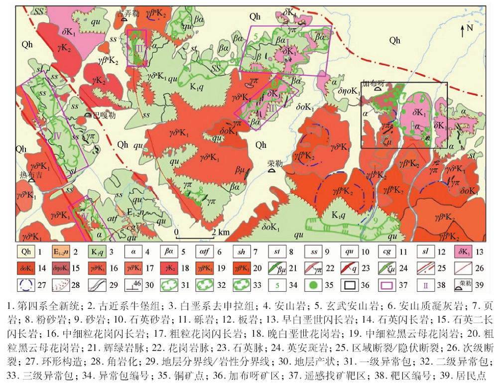
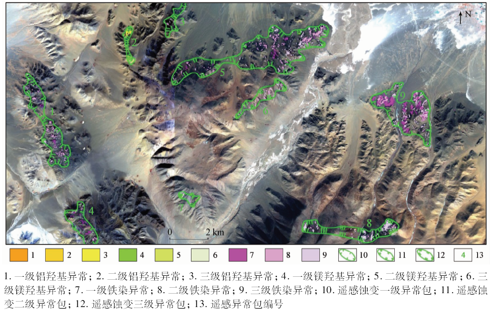
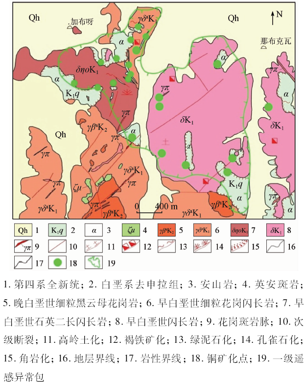
High-resolution remote sensing data have rich information and hence can be used to better identify micro-lithology, structure and other ore-controlling information. In order to study the extraction of ore-controlling information of high-resolution remote sensing data in Rongle area of Tibet where the elevation is high and the bedrock is exposed, the authors interpreted the ore-controlling information of strata, lithology, rock mass, structure, contact zone and other information closely related to copper polymetallic mineralization in this area on the basis of the best band combination determined by WorldView-2 high-resolution remote sensing data. Using ASTER data, the authors employed principal component analysis (PCA) to extract the mineralization-related remote sensing alteration information of iron stain, aluminum hydroxyl group and magnesium hydroxyl group. Based on comprehensive regional copper mineralization rules, the authors constructed a remote sensing prospecting model for ore-controlling information of magmatic hydrothermal copper deposits through human-computer interaction interpretation. Five prospecting targets were delineated and good mineralization clues were found through field investigation. The results provide basic information and reference basis for promoting local prospecting process. The results show that the high-resolution remote sensing data can meet the needs of mineral resources exploration and resource evaluation in the high-altitude environment hostile areas in Western China and highlight the fast, efficient and reliable application effect of high-resolution remote sensing.
付丽华, 张策. 基于高分遥感数据的西藏荣勒地区控矿信息提取[J]. 国土资源遥感, 2020, 32(1): 98-105.
Lihua FU, Ce ZHANG. Study of ore control information in Rongle area of Tibet based on high resolution remote sensing data. Remote Sensing for Land & Resources, 2020, 32(1): 98-105.
Zhang Z J, Pan S Y, Li M , et al. Establishment of lithological remote sensing interpretation keys in north Bayan Hara Mountain[J]. Remote Sensing for Land and Resources, 2017,29(1):199-207.doi: 10.6046/gtzyyg.2017.01.30.
Zhang W, Jin M S, Zhang S P , et al. Application of high resolution remote sensing data to ore-prospecting prediction in East Kunlun metallogenic belt[J]. Remote Sensing for Land and Resources, 2016,28(2):112-119.doi: 10.6046/gtzyyg.2016.02.18.
Fu L H, Zhang C, Wei B Z , et al. Analysis of metallogenic conditions and prospecting prediction by remote sensing technology in Daduoxiba area,Tibet[J]. Mineral Exploration, 2015,6(5):535-541.
Zhang Y F, Li L J, Feng C . The application of ASTER data to bauxite deposit pre-survey in Northern China:A case study of Mianchi area,Western Henan[J]. Remote Sensing for Land and Resources, 2012,24(1):48-52.doi: 10.6046/gtzyyg.2012.01.09.
Han H H, Wang Y L, Ren G L , et al. Extraction and application of altered mineral in prospecting from ASTER data in Fangshankou,Beishan[J]. Remote Sensing Technology and Application, 2016,31(2):368-377.
Yang J Z, Zhao Y L . Technical features of remote sensing and its application in the geological survey and mineral resources survey[J]. Mineral Exploration, 2015,6(5):529-534.
Wang Y J, Zhang C, Fu L H , et al. Report on Remote Sensing Geological Survey Results of Bangonghu—Nujiang Metallogenic Belt[R]. Shijiazhuang:Airborne Survey and Remote Sensing Center of Nuclear Industry, 2013.
Qian J P, Zhang Y, Zhao X X , et al. Extraction of linear structure and alteration information based on remote sensing image and ore-prospecting prognosis for Dongwu Banner,Inner Mongolia[J]. Remote Sensing for Land and Resources, 2013,25(3):109-117.doi: 10.6046/gtzyyg.2013.03.19.
Wang R G . Remote sensing investigation and analysis of geological disasters in the Wudong coal mine based on WorldView-2 data[J]. Remote Sensing for Land and Resources, 2016,28(2):132-138.doi: 10.6046/gtzyyg.2016.02.21.
Tang C, Chen J P, Zhang R S , et al. Alteration from ASTER remote sensing data in Ban Nu metallogenic belt,Gaize,Tibet[J]. Remote Sensing Technology and Application, 2013,28(1):122-128.
Fan Y H, Wang H, Yang X K , et al. Application of high-resolution remote sensing technology to the prospecting for rare metal mineralization belt[J]. Remote Sensing for Land and Resources, 2018,30(1):128-134.doi: 10.6046/gtzyyg.2018.01.18.
Xia Q, Yang W N, Zhao N . Extraction of remote sensing alteration information of Kosrap area in northern basin-mountain coupling zone of Tibetan Plateau[J]. Remote Sensing for Land and Resources, 2014,26(1):127-131.doi: 10.6046/gtzyyg.2014.01.22.
Jin M S, Wang H, Zhang W , et al. Method for extraction of ferric contamination anomaly from high-resolution remote sensing data and its applications[J]. Remote Sensing for Land and Resources, 2015,27(3):122-127.doi: 10.6046/gtzyyg.2015.03.20.
Zhang Z J, Gan F P, Li X Q , et al. The extraction of altered mineral information based on ASTER data:A case study of the Huangshan copper-nickel ore district in Hami[J]. Remote Sensing for Land and Resources, 2012,24(2):85-91.doi: 10.6046/gtzyyg.2012.02.16.
Bie X J, Zhang T B, Sun C M , et al. Study of methods for extraction of remote sensing information of rocks and altered minerals from Luobusha ophiolite in east Tibet[J]. Remote Sensing for Land and Resources, 2013,25(3):72-78.doi: 10.6046/gtzyyg.2013.03.13.
Qu X M, Wang R J, Xin H B , et al. Geochronology and geochemistry of igneous rocks related to the subduction of the Tethys oceanic plate along the Bangong Lake arc zone,the western Tibetan Plateau[J]. Geochimica, 2009,38(6):523-535.
Hu J, Wan Y W, Tao Z , et al. New geochemistry and geochronology evidences related to southward subduction of Tethys ocean basin in west segment of Bangonghu-Nujiang suture belt[J]. Journal of Chengdu University of Technology(Science and Technology Edition), 2014,41(4):505-514.
 2020, Vol. 32