Please wait a minute...
 
国土资源遥感  2020, Vol. 32 Issue (1): 120-129    DOI: 10.6046/gtzyyg.2020.01.17
     技术应用 本期目录 | 过刊浏览 | 高级检索 |
延安市土地生态风险时空格局演变研究
段艺芳1,2, 任志远1(), 周晓1, 孙艺杰1
1. 陕西师范大学地理科学与旅游学院,西安 710119
2. 聊城大学环境与规划学院,聊城 252000
Spatio-temporal variation in the land ecological risk of Yan’an City
Yifang DUAN1,2, Zhiyuan REN1(), Xiao ZHOU1, Yijie SUN1
1. College of Geography and Tourism, Shaanxi Normal University, Xi’an 710119, China
2. College of Environment and Planning, Liaocheng University, Liaocheng 252000, China
全文: PDF(5439 KB)   HTML  
输出: BibTeX | EndNote (RIS)      
摘要 

陕西省延安市作为国家退耕还林生态工程实施重点区、示范区,是我国生态问题集中体现区,研究其土地生态风险时空差异对区域土地可持续发展、差别化国土资源发展政策的制定具有重要意义。首先,依据延安市土地系统的基本特征,选取植被覆盖度指数、降水距平百分比指数、土地利用结构风险指数和土壤侵蚀指数4个风险指标,构建土地生态风险综合评价模型; 其次,基于像元尺度测算土地生态风险各因子指数及综合指数; 最后,结合探索性空间数据分析方法,分析了延安市2000—2015年间土地生态风险及空间集聚效应的时空演化规律,进而提出土地分区综合治理的建议。研究结果表明,延安市土地生态整体状况良好,各生态因子及综合风险整体呈降低态势,但宝塔区和洛川县较高且高等级综合风险区面积呈小幅增加态势。延安市土地综合生态风险呈现较强的空间集聚状态,热点区包括位于各区县城镇建设区的城镇热点区和分布在子长县、安塞区、延长县、延川县和吴起县5区县的北部热点区,冷点区则主要位于生态环境状况较好的东南部黄龙县、宜川县,西南部黄陵县、富县以及甘泉县西南部等地区。得益于国家退耕还林(草)及封山育林等生态工程的实施,热点集聚程度总体呈逐渐减弱趋势,但宝塔区内城镇热点区面积持续增加,应注意加强生态管理; 受气候干旱的影响,富县西北部、宜川县西部冷点区范围呈缩小态势,应注意优化水资源的调配。

服务
把本文推荐给朋友
加入引用管理器
E-mail Alert
RSS
作者相关文章
段艺芳
任志远
周晓
孙艺杰
关键词 土地生态风险探索性空间数据分析空间集聚延安市    
Abstract

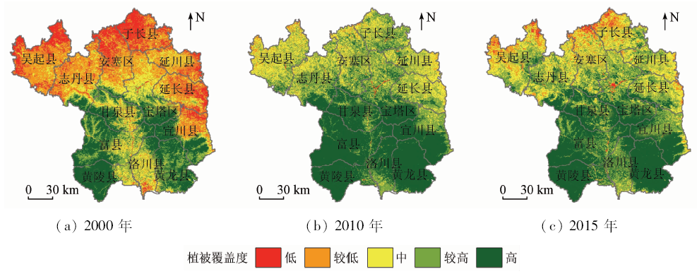
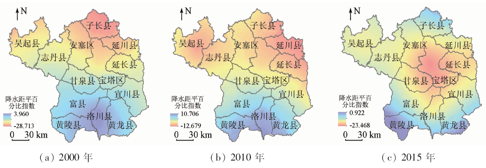
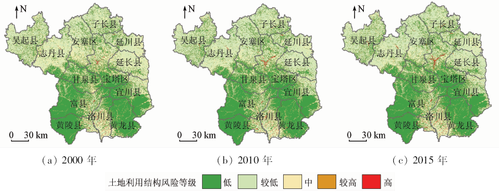
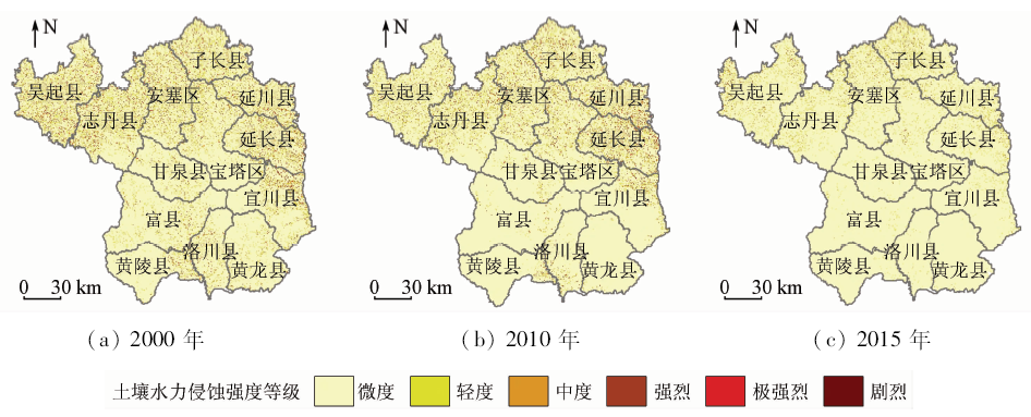
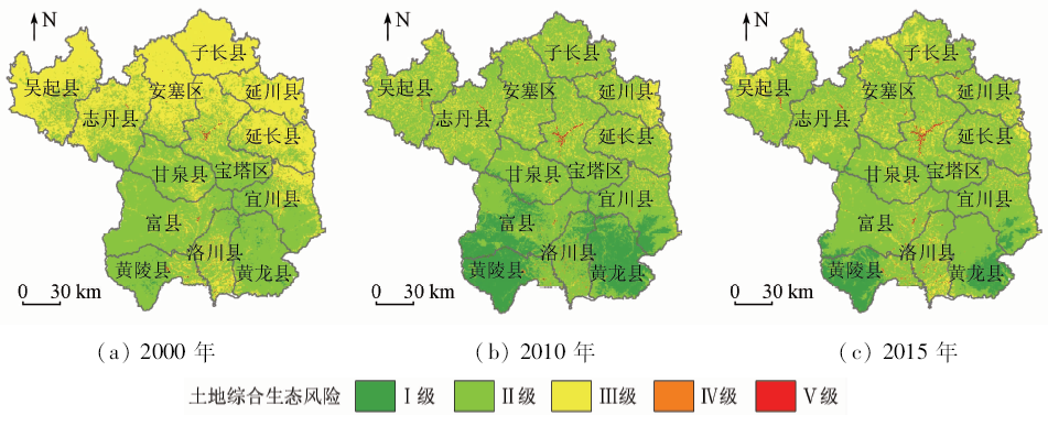
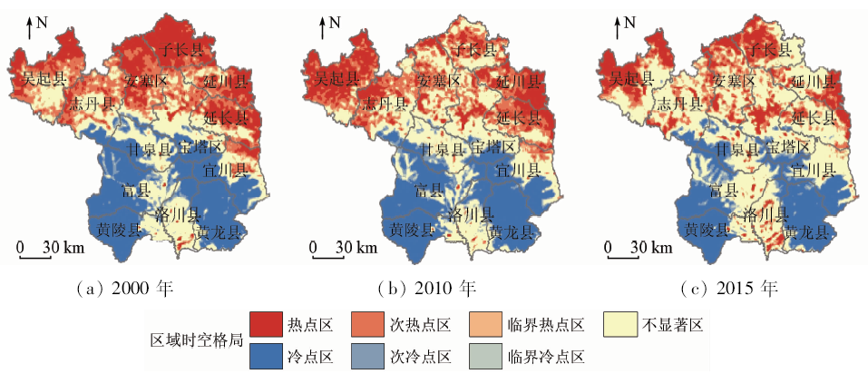
As a key and demonstration area for the implementation of the national ecological project of returning farmland to forestry, Yan’an City is a concentrated area of ecological problems in China. It is of great significance to study the spatial and temporal differences of land ecological risks for the sustainable development of regional land and the formulation of differentiated land and resources development policies. According to the basic characteristics of land ecosystem, four risk indicators, namely vegetation coverage, percentage anomaly precipitation, land use structure risk index and soil erosion index, were selected to construct a comprehensive evaluation model of land ecological risk. Then on the basis of pixel scale, each factor index and comprehensive index of land ecological risk were calculated. In combination with exploratory spatial data analysis (ESDA), the spatial and temporal evolution of land ecological risk and spatial agglomeration effect in Yan’an City from 2000 to 2015 was analyzed. Then the corresponding suggestions for comprehensive management of land in different regions were put forward. The results are as follows: The land ecology of Yan’an City is in good condition as a whole, whereas the land comprehensive ecological risk and the risk of the four ecological factors temporally decrease on the whole; nevertheless, the area of Baota District and Luochuan County is higher in this aspect, and high comprehensive risk areas increase slightly. The land comprehensive ecological risk of Yan’an City shows a strong spatial agglomeration. Hot spots include urban hot spots located in urban construction areas and northern hot spots distributed in five districts and counties of Zichang County, Ansai District, Yanchuan County, and Wuqi County. The cold points are mainly located in Huanglong County, Yichuan County, Huangling County, Fuxian County and the southwest area of Ganquan County. Thanks to the implementation of national eco-engineering measures such as returning farmland to forestry (grassland) and closing hillsides for reforestation, the agglomeration degree of hot spots has been gradually weakening. However, the area of urban hot spots in Baota District continues to increase, and hence attention should be paid to strengthening ecological management. As cold spot areas in northwest Fuxian and western Yichuan County has been shrinking because of climate drought, attention should be paid to optimizing the allocation of water resources.

Key wordsland ecological risk    exploratory spatial data analysis    spatial agglomeration    Yan’an City
收稿日期: 2019-03-15      出版日期: 2020-03-14
:  TP79  
基金资助:国家自然科学基金项目“我国生态脆弱区能源开发生态效应测评与调控研究”(编号: 41371523)
通讯作者: 任志远
作者简介: 段艺芳(1980-),女,讲师,博士,主要从事资源环境遥感与GIS研究。Email: duanyifang@snnu.edu.cn。
引用本文:   
段艺芳, 任志远, 周晓, 孙艺杰. 延安市土地生态风险时空格局演变研究[J]. 国土资源遥感, 2020, 32(1): 120-129.
Yifang DUAN, Zhiyuan REN, Xiao ZHOU, Yijie SUN. Spatio-temporal variation in the land ecological risk of Yan’an City. Remote Sensing for Land & Resources, 2020, 32(1): 120-129.
链接本文:  
https://www.gtzyyg.com/CN/10.6046/gtzyyg.2020.01.17      或      https://www.gtzyyg.com/CN/Y2020/V32/I1/120
Fig.1  研究区概况
风险指标 计算公式或模型 注释 标准化公式
植被覆盖度指数 VFC=NDVI-NDVIminNDVImax-NDVImin VFC为植被覆盖度指数[16,17],值越大,风险越小; NDVIminNDVImax分别为归一化植被指数的最小值和最大值 逆向标准化
PVFC=VFCmax-VFCVFCmax-VFCmin
降水距平百分比指数 Si=Ri-R-a-bR-a-b·100% Si为第i年降水距平百分比指数[18,19],值越大,风险越小; Ri为第i年年降水量; Rˉa-b为多年平均降水量 逆向标准化
PS=Smax-SSmax-Smin
土地利用结构风险指数 ERI=i=1nBiB·Wi·100% ERI为土地利用结构风险指数,值越大,风险越大; Bi为第i类土地利用类型面积; B为研究区总面积; Wi表示第i类土地利用类型生态风险权重,借鉴臧淑英[7]和马彩虹[8]的研究成果,采用AHP法确定。林地、草地、水体、耕地、建设用地和未利用地的风险权重分别为0.035,0.055,0.06,0.314,0.402和0.134 正向标准化
PERI=ERI-ERIminERImax-ERImin
土壤侵蚀风险指数 A=R·K·C·LS·T A为土壤侵蚀风险指数,t·hm-1,值越大,风险越大; R为降雨侵蚀力因子; K为土壤可蚀性因子; C为覆盖与管理因子; LS为坡长坡度因子; T为土壤保持措施因子,依据坡度范围: ≤6°,(6°,15°],(15°,25°],﹥25°分别取值为0.20,0.35,0.65和0.80; C,LST为无量纲因子,采用相应的经验公式模型计算得到[20,21,22] 正向标准化
PA=A-AminAmax-Amin
Tab.1  风险评价指标的选择及标准化方法
等级 Ⅰ级 Ⅱ级 Ⅲ级 Ⅳ级 Ⅴ级
风险指数 ≤0.1 (0.1,0.25] (0.25,0.4] (0.4,0.55] >0.55
风险状态 较低 中等 较高
Tab.2  土地生态风险等级划分标准
Fig.2  不同时期植被覆盖度空间分布
Fig.3  不同时期降水距平百分比指数空间分布
Fig.4  不同时期土地利用结构风险等级分布
Fig.5  不同时期土壤水力侵蚀强度等级分布
Fig.6  2000—2015年土地综合生态风险时空分布
区县 2000年 2010年 2015年
指数 等级 指数 等级 指数 等级
黄陵县 0.034 I 0.166 II 0.055 I
延长县 0.819 V 0.696 IV 0.533 III
安塞区 0.713 IV 0.551 IV 0.59 IV
志丹县 0.709 IV 0.498 III 0.505 III
吴起县 0.741 IV 0.546 III 0.66 IV
宝塔区 0.474 III 0.436 III 0.487 III
延川县 0.782 V 0.785 V 0.622 IV
子长县 0.694 IV 0.559 IV 0.625 IV
甘泉县 0.212 II 0.148 I 0.284 II
富县 0.073 I 0.034 I 0.159 II
洛川县 0.474 III 0.566 IV 0.523 III
宜川县 0.396 III 0.209 II 0.255 II
黄龙县 0.016 I 0.057 I 0.072 I
Tab.3  各区县土地综合生态风险指数及等级
Fig.7  延安市土地综合生态风险冷热点区域时空格局演化
[1] Fan J H, Wang Y, Zhou Z . Dynamic ecological risk assessment and management of land use in the middle reaches of the Heihe River based on landscape patterns and spatial statistics[J]. Sustainability, 2016,8(6):536-551.
[2] 刘勇, 邢育刚, 李晋昌 . 土地生态风险评价的理论基础及模型构建[J]. 中国土地科学, 2012,26(6):20-25.
Liu Y, Xing Y G, Li J C . Theoretical basis and model development for land ecological risk assessment[J]. China Land Sciences, 2012,26(6):20-25.
[3] Hunsaker C T, Graham R L, Suter G W , et al. Assessing ecological risk on a regional scale[J]. Environmental Management, 1990,14(3):325-332.
[4] 陈辉, 刘劲松, 曹宇 , 等. 生态风险评价研究进展[J]. 生态学报, 2006,26(5):1558-1566.
Chen H, Liu J S, Cao Y , et al. Progresses of ecological risk assessment[J]. Acta Ecologica Sinica, 2006,26(5):1558-1566.
[5] 傅伯杰 . 我国生态系统研究的发展趋势与优先领域[J]. 地理研究, 2010,29(3):383-396.
Fu B J . Trends and priority areas in ecosystem research of China[J]. Geographical Research, 2010,29(3):383-396.
[6] 任志远, 刘焱序 . 基于价值量的区域生态安全评价方法探索——以陕北能源区为例[J]. 地理研究, 2013,32(10):1771-1781.
Ren Z Y, Liu Y X . Exploring the regional ecological security evaluation methods based on values:A case study in the energy region of northern Shaanxi[J]. Geographical Research, 2013,32(10):1771-1781.
[7] 臧淑英, 梁欣, 张思冲 . 基于GIS的大庆市土地利用生态风险分析[J]. 自然灾害学报, 2005,14(4):141-145.
Zang S Y, Liang X, Zhang S C . GIS-based analysis of ecological risk on land-use in Daqing City[J]. Journal of Natural Disasters, 2005,14(4):141-145.
[8] 马彩虹 . 陕西黄土台塬区土地生态风险时空差异性评价[J]. 水土保持研究, 2014,21(5):216-220.
Ma C H . Assessment on spatio-temporal ecological risk in loess highland region of Shaanxi Province[J]. Research of Soil and Water Conservation, 2014,21(5):216-220.
[9] 莫宏伟, 任志远 . 风沙过渡区土地生态价值及生态风险动态研究——以陕北神木县为例[J]. 中国沙漠, 2010,30(2):357-362.
Mo H W, Ren Z Y . Study on changes of land ecosystem value and ecological risk in sand blowing region:A case study over Shenmu County of Shaanxi Province[J]. Journal of Desert Research, 2010,30(2):357-362.
[10] 徐兰, 罗维, 周宝同 . 基于土地利用变化的农牧交错带典型流域生态风险评价——以洋河为例[J]. 自然资源学报, 2015,30(4):580-590.
Xu L, Luo W, Zhou B T . Landscape ecological risk assessment of farming-pastoral ecozone based on land use change—a case study of the Yanghe Watershed,China[J]. Journal of Natural Resources, 2015,30(4):580-590.
[11] 周汝佳, 张永战, 何华春 . 基于土地利用变化的盐城海岸带生态风险评价[J]. 地理研究, 2016,35(6):1017-1028.
Zhou R J, Zhang Y Z, He H C . Ecological risk assessment based on land use changes in the coastal area in Yancheng City[J]. Geographical Research, 2016,35(6):1017-1028.
[12] 孙贤斌, 刘红玉 . 江苏盐城市海滨土地利用对景观生态风险的影响[J]. 国土资源遥感, 2011,23(3):140-145.doi: 10.6046/gtzyyg.2011.03.25.
Sun X B, Liu H Y . The effect of land use on landscape ecological risk in Yancheng Coastal Area,Jiangsu Province[J]. Remote Sensing for Land and Resources, 2011,23(3):140-145.doi: 10.6046/gtzyyg.2011.03.25.
[13] 彭文君, 舒英格 . 基于GIS的石漠化山区县域土地利用空间变化的生态风险测度[J]. 水土保持研究, 2018,25(1):342-348,355.
Peng W J, Shu Y G . Assessment on ecological risk of land use spatial change at county level in the rocky desertification mountainous area based on GIS[J]. Research of Soil and Water Conservation, 2018,25(1):342-348,355.
[14] 孙洪波, 杨桂山, 苏伟忠 , 等. 沿江地区土地利用生态风险评价——以长江三角洲南京地区为例[J]. 生态学报, 2010,30(20):5616-5625.
Sun H B, Yang G S, Su W Z , et al. Ecological risk assessment of land use in the area along Changjiang River:A case study of Nanjing,China[J]. Acta Ecologica Sinica, 2010,30(20):5616-5625.
[15] 虞燕娜, 朱江, 吴绍华 , 等. 多风险源驱动下的土地生态风险评价——以江苏省射阳县为例[J]. 自然资源学报, 2016,31(8):1264-1274.
Yu Y N, Zhu J, Wu S H , et al. Assessment of land ecological risks driven by multi-sources:A case study of Sheyang County,Jiangsu Province[J]. Journal of Natural Resources, 2016,31(8):1264-1274.
[16] 王朗, 傅伯杰, 吕一河 , 等. 生态恢复背景下陕北地区植被覆盖的时空变化[J]. 应用生态学报, 2010,21(8):2109-2116.
Wang L, Fu B J, Lyu Y H , et al. Spatio-temporal variation of vegetation cover in northern Shaanxi Province under the background of ecological restoration[J]. Chinese Journal of Applied Ecology, 2010,21(8):2109-2116.
[17] 赵舒怡, 宫兆宁, 刘旭颖 . 2001—2013年华北地区植被覆盖度与干旱条件的相关分析[J]. 地理学报, 2015,70(5):717-729.
Zhao S Y, Gong Z N, Liu X Y . Correlation analysis between vegetation coverage and climate drought conditions in North China during 2001—2013[J]. Acta Geographica Sinica, 2015,70(5):717-729.
[18] 袁文平, 周广胜 . 干旱指标的理论分析与研究展望[J]. 地球科学进展, 2004,19(6):982-991.
Yuan W P, Zhou G S . Theoratical study and research prospect on drought indices[J]. Advances in Earth Science, 2004,19(6):982-991.
[19] Yu M X, Li Q F, Hayes M J , et al. Are droughts becoming more frequent or severe in China based on the standardized precipitation evapotranspiration index:1951—2010?[J]. International Journal of Climatology, 2014,34(3):545-558.
[20] Renard K G, Foster R, Weesies G , et al. Predicting Soil Erosion by Water:A Guide to Conservation Planning with the Revised Universal Soil Loss equation(RUSLE)[M]. Agricultural Handbook.Washington,DC(USA):ARS; 1997.
[21] 冯强, 赵文武 . USLE/RUSLE中植被覆盖与管理因子研究进展[J]. 生态学报, 2014,34(16):4461-4472.
Feng Q, Zhao W W . The study on cover-management factor in USLE and RUSLE:A review[J]. Acta Ecologica Sinica, 2014,34(16):4461-4472.
[22] 蒋欣阳, 贾志斌, 张雪峰 , 等. 内蒙古锡林郭勒盟景观尺度土壤保持功能的空间分布[J]. 地球环境学报, 2018,9(1):64-78.
Jiang X Y, Jia Z B, Zhang X F , et al. Soil conservation function and its spatial distribution of different landscapes in Xilin Gol League,Inner Mongolia[J]. Journal of Earth Environment, 2018,9(1):64-78.
[23] 张广纳, 邵景安, 王金亮 , 等. 三峡库区重庆段农村面源污染时空格局演变特征[J]. 自然资源学报, 2015,30(7):1197-1209.
Zhang G N, Shao J A, Wang J L , et al. Spatial and temporal variations of agricultural non-point source pollution in the Three Gorges Reservoir Area of Chongqing[J]. Journal of Natural Resources, 2015,30(7):1197-1209.
[24] 马世五, 谢德体, 张孝成 , 等. 三峡库区重庆段土地生态状况时空格局演变特征[J]. 生态学报, 2018,38(23):8512-8525.
Ma S W, Xie D T, Zhang X C , et al. Spatiotemporal variation in the ecological status of the Three Gorges Reservoir area in Chongqing,China[J]. Acta Ecologica Sinica, 2018,38(23):8512-8525.
[25] 韩磊, 朱会利, 刘钊 . 延安市退耕还林前后土地利用动态变化分析[J]. 西北师范大学学报(自然科学版), 2017,53(5):101-108.
Han L, Zhu H L, Liu Z . Analysis on land use dynamic changes of pre and post returning farmland to forestland in Yan’an City[J]. Journal of Northwest Normal University(Natural Science), 2017,53(5):101-108.
[26] 侯孟阳, 姚顺波, 邓元杰 , 等. 格网尺度下延安市生态服务价值时空演变格局与分异特征——基于退耕还林工程的实施背景[J]. 自然资源学报, 2019,34(3):539-552.
Hou M Y, Yao S B, Deng Y J , et al. Spatial-temporal evolution pattern and differentiation of ecological service value in Yan’an City at the grid scale based on sloping land conversion program[J]. Journal of Natural Resources, 2019,34(3):539-552.
[1] 宋奇, 冯春晖, 马自强, 王楠, 纪文君, 彭杰. 基于1990—2019年Landsat影像的干旱区绿洲土地利用变化与模拟[J]. 自然资源遥感, 2022, 34(1): 198-209.
[2] 任超锋, 蒲禹池, 张福强. 顾及地理空间信息的无人机影像匹配像对提取方法[J]. 自然资源遥感, 2022, 34(1): 85-92.
[3] 臧丽日, 杨树文, 申顺发, 薛庆, 秦肖伟. 耦合分水岭与形态学的特殊纹理影像配准算法[J]. 自然资源遥感, 2022, 34(1): 76-84.
[4] 潘建平, 徐永杰, 李明明, 胡勇, 王春晓. 结合相关系数和特征分析的植被区域自动变化检测研发[J]. 自然资源遥感, 2022, 34(1): 67-75.
[5] 薛白, 王懿哲, 刘书含, 岳明宇, 王艺颖, 赵世湖. 基于孪生注意力网络的高分辨率遥感影像变化检测[J]. 自然资源遥感, 2022, 34(1): 61-66.
[6] 江娜, 陈超, 韩海丰. 海岸带地类统计模型中DEM空间尺度优选方法[J]. 自然资源遥感, 2022, 34(1): 34-42.
[7] 吴芳, 李瑜, 金鼎坚, 李天祺, 郭华, 张琦洁. 无人机三维地障信息提取技术应用于航空物探飞行轨迹规划[J]. 自然资源遥感, 2022, 34(1): 286-292.
[8] 王茜, 任广利. 高光谱遥感异常信息在阿尔金索拉克地区铜金矿找矿工作中的应用[J]. 自然资源遥感, 2022, 34(1): 277-285.
[9] 刘文, 王猛, 宋班, 余天彬, 黄细超, 江煜, 孙渝江. 基于光学遥感技术的冰崩隐患遥感调查及链式结构研究——以西藏自治区藏东南地区为例[J]. 自然资源遥感, 2022, 34(1): 265-276.
[10] 姚金玺, 张志, 张焜. 基于GEE的诺木洪洪积扇植被时空变化特征、成因及趋势分析[J]. 自然资源遥感, 2022, 34(1): 249-256.
[11] 武艺杰, 孔雪松. 江苏省“生态-农业-建设”用地空间格局模拟及发展模式选择[J]. 自然资源遥感, 2022, 34(1): 238-248.
[12] 张秦瑞, 赵良军, 林国军, 万虹麟. 改进遥感生态指数的宜宾市三江汇合区生态环境评价[J]. 自然资源遥感, 2022, 34(1): 230-237.
[13] 胡盈盈, 戴声佩, 罗红霞, 李海亮, 李茂芬, 郑倩, 禹萱, 李宁. 2001—2015年海南岛橡胶林物候时空变化特征分析[J]. 自然资源遥感, 2022, 34(1): 210-217.
[14] 孙一鸣, 张宝钢, 吴其重, 刘奥博, 高超, 牛静, 何平. 国产微景一号小卫星影像的城市裸地识别应用[J]. 自然资源遥感, 2022, 34(1): 189-197.
[15] 郑修诚, 周斌, 雷惠, 黄祺宇, 叶浩林. 基于GEE的杭州湾慈溪段潮滩提取及时空变化分析[J]. 自然资源遥感, 2022, 34(1): 18-26.
Viewed
Full text


Abstract

Cited

  Shared   
  Discussed   
京ICP备05055290号-2
版权所有 © 2015 《自然资源遥感》编辑部
地址:北京学院路31号中国国土资源航空物探遥感中心 邮编:100083
电话:010-62060291/62060292 E-mail:zrzyyg@163.com
本系统由北京玛格泰克科技发展有限公司设计开发