1. Faculty of Geosciences and Environmental Engineering, Southwest Jiaotong University, Chengdu 610031, China 2. State-Province Joint Engineering Laboratory of Spatial Information Technology of High-Speed Railway Safety, Chengdu 610031, China 3. School of Civil Engineering and Architecture, Southwest Petroleum University, Chengdu 610500, China
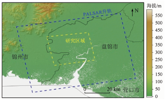
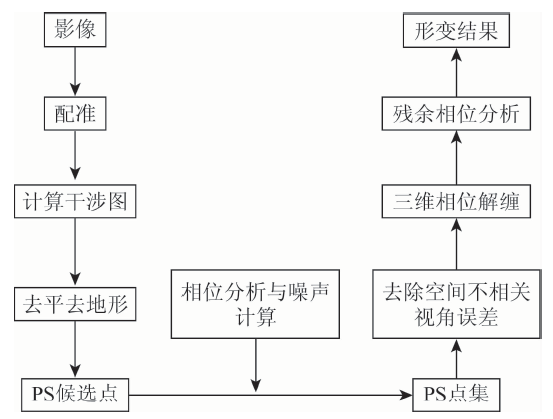
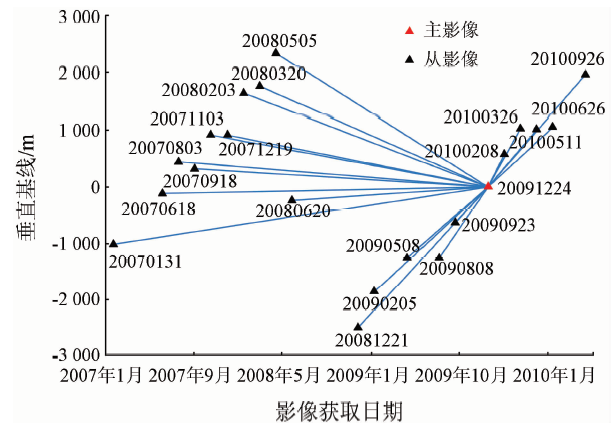
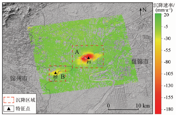
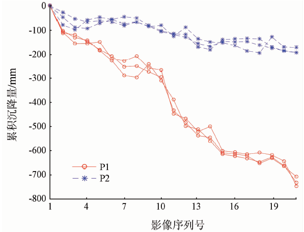
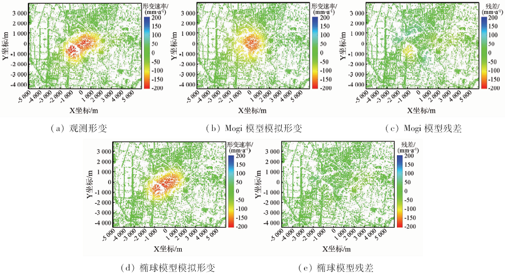
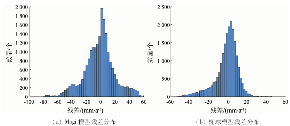
The inversion of reservoir parameters and production for the oil field can grasp reservoir status and production changes in time and effectively monitor reservoir health and safety. At present, the study of reservoir parameter inversion is very insufficient in China. The authors chose Shuguang Oil Production Plant, the largest oil production plant in the Liaohe Oilfield, as the research object. Using 21 L-band ALOS/PALSAR data obtained from January 2007 to September 2010, the authors employed StaMPS to extract deformation results. Based on these deformation results, the authors used Mogi model and Finite Prolate Spheroidal model to invert and analyze reservoir parameters respectively, with the inversion results compared with those of Okada model. The results are as follows: ① The subsidence of Shuguang Oil Production Plant is remarkable. The maximum subsidence rate is -189.6 mm/year, the maximum cumulative subsidence is about 750 mm, and the subsidence area is about 28 km 2. ② Compared with Okada model and Mogi model, Finite Prolate Spheroidal model has the highest accuracy of reservoir depth inversion, and the simulated deformation results are in the best agreement with the observed deformation results, which shows that the inversion results of Finite Prolate Spheroidal model are more reliable and more suitable for the inversion of reservoir parameters in this oilfield. This study can provide scientific reference for InSAR subsidence monitoring and reservoir parameter inversion in the oilfield.
杨崇, 刘国祥, 于冰, 张波, 张瑞, 王晓文. 基于InSAR形变的辽河油田曙光采油厂储层参数反演[J]. 国土资源遥感, 2020, 32(1): 209-215.
Chong YANG, Guoxiang LIU, Bing YU, Bo ZHANG, Rui ZHANG, Xiaowen WANG. Inversion of reservoir parameters in Shuguang Oil Production Plant of the Liaohe Oilfield based on InSAR deformation. Remote Sensing for Land & Resources, 2020, 32(1): 209-215.
Sun H, Zhang Q, Yang C S , et al. PS-InSAR monitoring of land subsidence in the Panjin region of Liaoning Province[J]. Shanghai Land and Resources, 2014(4):68-71.
[4]
Kooij M . Land subsidence measurements at the Belridge Oil Fields from ERS InSAR data[C]// Proceedings of the Third ERS Symposium,Florence: 1997, 1853-1858.
[5]
Fielding E J, Blom R G, Goldstein R M . Rapid subsidence over oil fields measured by SAR interferometry[J]. Geophysical Research Letters, 1998,25(17):3215-3218.
Mu J Q, Yao G Q . Time series Radar interferometry method for surface deformation monitoring[J]. Remote Sensing for Land and Resources, 2007,19(3):28-30.doi: 10.6046/gtzyyg.2007.03.06.
Ge D Q, Wang Y, Fan J H , et al. A study of surface deformation monitoring using differential SAR interferometry technique and an analysis of its key problems[J]. Remote Sensing for Land and Resources, 2007,19(4):14-22.doi: 10.6046/gtzyyg.2007.04.04.
[9]
Zebker H A, Rosen P A, Hensley S . Atmospheric effects in interferometric synthetic aperture Radar surface deformation and topographic maps[J]. Journal of Geophysical Research, 1997,102(B4):7547-7563.
[10]
Ferretti A, Prati C, Rocca F . Non-linear subsidence rate estimation using permanent scatterers in differential SAR interferometry[J]. IEEE Transactions on Geoscience and Remote Sensing, 2000,38(5):2202-2212
Liu G X, Zhang R, Li T , et al. Extracting 3D ground deformation velocity field by multi-platform persistent scatter SAR interferometry[J]. Chinese Journal of Geophysics, 2012,55(8):2598-2610.
Tang J, Liu G X, Song Y F , et al. Significant subsidence detection and analysis by PALSAR and ASAR PSI[J]. Journal of Remote Sensing, 2015,19(6):1019-1029.
[13]
Hooper A, Zebker H, Segall P , et al. A new method for measuring deformation on volcanoes and other natural terrains using InSAR persistent scatterers[J]. Geophysical Research Letters. 2004,31(23):L23611.
[14]
Hooper A . Persistent Scatterer Radar Interferometry for Crustal Deformation Studies and Modeling of Volcanic Deformation[D]. San Francisco:Stanford University, 2006.
[15]
Vasco D W, Ferretti A, Novali F . Estimating permeability from quasi-static deformation:Temporal variations and arrival-time inversion[J]. Geophysics, 2008,73(6):O37-O52.
[16]
Vasco D W, Ferretti A, Novali F . Reservoir monitoring and characterization using satellite geodetic data:Interferometric synthetic aperture Radar observations from the Krechba field,Algeria[J]. Geophysics, 2008, 76(6:WA113-WA122.
[17]
Klemm H, Quseimi I, Novali F , et al. Monitoring horizontal and vertical surface deformation over a hydrocarbon reservoir by PSInSAR[J]. First Break, 2010,28(5):29-37.
[18]
Khakim M Y N, Tsuji T, Matsuoka T . Geomechanical modeling for InSAR-derived surface deformation at steam-injection oil sand fields[J]. Journal of Petroleum Science and Engineering, 2012, 96-97:152-161.
[19]
Ji L Y, Zhang Y, Wang Q L , et al. Detecting land uplift associated with enhanced oil recovery using InSAR in the Karamay oil field,Xinjiang,China[J]. International Journal of Remote Sensing, 2016,37(7):1527-1540.
Liu Y L . Land Subsidence Monitoring and Correlation Analysis with Ground Fluid Exploitation Using Time Series InSAR Technique over the Yellow River Delta (China) [D]. Qingdao:Institute of Oceanography,Chinese Academy of Sciences, 2016.
[21]
Sun H, Zhang Q, Zhao C Y , et al. Monitoring land subsidence in the southern part of the lower Liaohe plain,China with a multi-track PS-InSAR technique[J]. Remote Sensing of Environment, 2017,188:73-84.
[22]
Carnec C, Fabriol H . Monitoring and modeling land subsidence at the Cerro Prieto Geothermal Field,Baja California, Mexico,using SAR interferometry[J]. Geophysical Research Letters, 1999,26(9):1211-1214.
[23]
Zhong L, Timothy M . Interferometric synthetic aperture Radar study of Okmok volcano,Alaska,1992—2003:Magma supply dynamics and postemplacement lava flow deformation[J]. Journal of Geophysical Research, 2005,110(B2):B02403.
[24]
Mogi K . Relations between the eruptions of various volcanoes and the deformations of the ground surfaces around them[J]. Bulletin of the Earthquake Research Institute,University of Tokyo, 1958,36:99-134.
[25]
Davis P M . Surface deformation due to inflation of an arbitrarily oriented triaxial ellipsoidal cavity in an elastic half-space,with reference to Kilauea volcano,Hawaii[J]. Journal of Geophysical Research:Solid Earth, 1986,91(B7):7429-7438.
[26]
Yang X M, Davis P M, Dieterich J H . Deformation from inflation of a dipping finite prolate spheroid in an elastic half-space as a model for volcanic stressing[J]. Journal of Geophysical Research:Solid Earth, 1988,93(B5):4249-4257.
[27]
Press W H, Flannery B P, Teukolsky S A , et al. Numerical Recipes in C:the Art of Scientific Computing[M]. Cambridge: Cambridge University Press 1992: 176-177.
[28]
沈阳地质矿产研究所. 东北平原地面沉降调查[R]. 沈阳:沈阳地质矿产研究所, 2009.
Shenyang Institute of Geology and Mineral Resources. The Land Subsidence Investigation of Northeast Plain[R]. Shenyang:Shenyang Institute of Geology and Mineral Resources, 2009.
 2020, Vol. 32
  ), 于冰3, 张波1, 张瑞1,2, 王晓文1