|
|
|
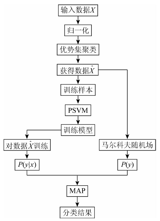
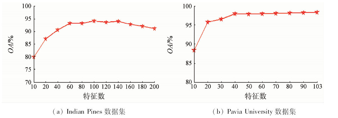
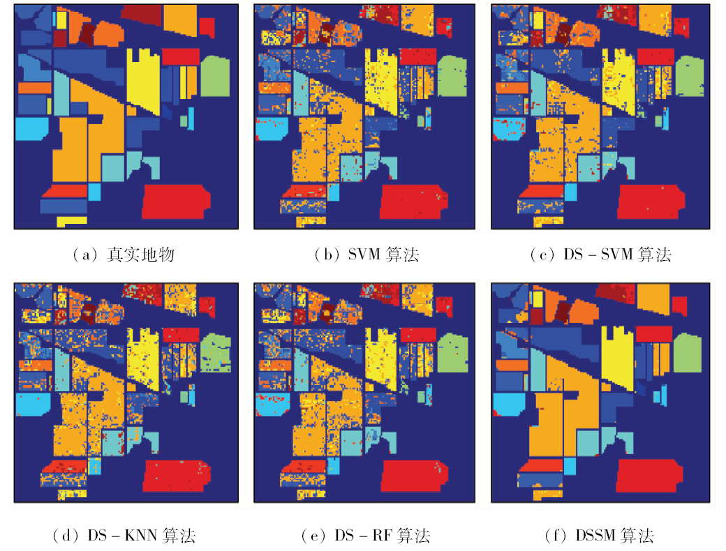
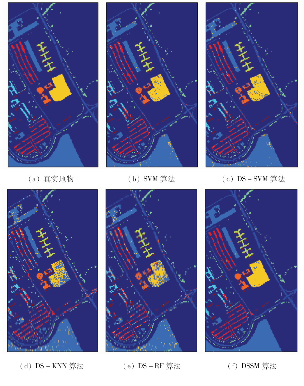
Abstract In order to make full use of the abundant spectral information and spatial information of hyperspectral images, this paper proposes a hyperspectral image classification algorithm based on dominant sets clustering and Markov random fields. First of all, the local spectral-spatial consistency of hyperspectral images is analyzed, the measurement of both band informativeness and independence is completed, an un-directed weighting graph is constructed and dominant sets clustering method is used to select the optimal band subset which preserves good structure information. Secondly, the local spectral-spatial consistency of adjacent pixels after the band selection is established by using Markov random fields, which makes the context information of the image space effectively used. Finally, according to the Bayesian theorem, the hyperspectral image classification problem is transformed into the maximum posterior probability which can solve the problem and yield the classification results. Experiments on two datasets, i.e., Indian Pines and Pavia University, show that this algorithm can achieve higher overall classification accuracy and Kappa coefficient than other similar algorithms.
|
| Keywords
dominant sets
clustering
band selection
Markov random fields
hyperspectral image
classification
|
|
|
|
Corresponding Authors:
Yue GUO
E-mail: GY_Gina@163.com
|
|
Issue Date: 23 May 2019
|
|
|
| [1] |
叶珍, 白璘, 粘永健 . 基于Gabor特征与局部保护降维的高光谱图像分类算法[J]. 光学学报, 2016,36(10):504-513.
|
| [1] |
Ye Z, Bai L, Nian Y J . Hyperspectral image classification algorithm based on Gabor feature and locality-preserving dimensionality reduction[J]. Acta Optica Sinica, 2016,36(10):504-513.
|
| [2] |
侯榜焕, 张耿, 王飞 , 等. 结合多尺度空间滤波和层级网络的基于结构保持的高光谱波段选择[J]. 光子学报, 2017,46(5):179-188.
|
| [2] |
Hou B H, Zhang G, Wang F , et al. Feature selection based on structure preserving for hyperspectral image combination with multi-scale spatial filtering and hierarchical network[J]. Acta Photonica Sinica, 2017,46(5):179-188.
|
| [3] |
Li J, Zhang H, Zhang L . Efficient superpixel-level multitask joint sparse representation for hyperspectral image classification[J]. IEEE Transactions on Geoscience and Remote Sensing, 2015,53(10):5338-5351.
doi: 10.1109/TGRS.2015.2421638
url: http://ieeexplore.ieee.org/document/7097693/
|
| [4] |
Albarracin J F H, Santos J A D, Torres R D S. Learning to combine spectral indices with genetic programming [C]//29th SIBGRAPI Conference on Graphics,Patterns and Images.Sao Paulo:IEEE, 2017: 408-415.
|
| [5] |
Vaiphasa C, Skidmore A K , Boer W F D ,et al.A hyperspectral band selector for plant species discrimination[J]. ISPRS Journal of Photogrammetry and Remote Sensing, 2007,62(3):225-235.
doi: 10.1016/j.isprsjprs.2007.05.006
url: https://linkinghub.elsevier.com/retrieve/pii/S0924271607000512
|
| [6] |
Martínez-Usómartinez-Uso A, Pla F, Sotoca J M , et al. Clustering-based hyperspectral band selection using information measures[J]. IEEE Transactions on Geoscience and Remote Sensing, 2007,45(12):4158-4171.
doi: 10.1109/TGRS.2007.904951
url: http://ieeexplore.ieee.org/document/4378560/
|
| [7] |
Hou J, Xu E, Chi L, et al. Robust clustering based on dominant sets [C]//22nd International Conference on Pattern Recognition.Stockholm:IEEE, 2014: 1466-1471.
|
| [8] |
Hou J, Pelillo M . A simple feature combination method based on dominant sets[J]. Pattern Recognition, 2013,46(11):3129-3139.
doi: 10.1016/j.patcog.2013.04.005
url: https://linkinghub.elsevier.com/retrieve/pii/S0031320313001751
|
| [9] |
Zhu G K, Huang Y C, Lei J S , et al. Unsupervised hyperspectral band selection by dominant set extraction[J]. IEEE Transactions on Geoscience and Remote Sensing, 2016,54(1):227-239.
doi: 10.1109/TGRS.2015.2453362
url: http://ieeexplore.ieee.org/document/7166333/
|
| [10] |
Pavan M, Pelillo M . Dominant sets and pairwise clustering[J]. IEEE Transactions on Pattern Analysis and Machine Intelligence, 2007,29(1):167-172.
doi: 10.1109/TPAMI.2007.250608
url: http://ieeexplore.ieee.org/document/4016559/
|
| [11] |
Hou J, Xu E, Liu W X , et al. A density-based enhancement to dominant sets clustering[J]. IET Computer Vision, 2013,7(5):354-361.
doi: 10.1049/iet-cvi.2013.0072
url: https://digital-library.theiet.org/content/journals/10.1049/iet-cvi.2013.0072
|
| [12] |
Yang X, Liu H, Latecki L J . Contour-based object detection as dominant set computation[J]. Pattern Recognition, 2012,45(5):1927-1936.
doi: 10.1016/j.patcog.2011.11.010
url: https://linkinghub.elsevier.com/retrieve/pii/S0031320311004626
|
| [13] |
Hamid R, Maddi S, Johnson A , et al. A novel sequence representation for unsupervised analysis of human activities[J]. Artificial Intelligence, 2009,173(14):1221-1244.
doi: 10.1016/j.artint.2009.05.002
url: https://linkinghub.elsevier.com/retrieve/pii/S0004370209000629
|
| [14] |
贺金鑫, 陈圣波, 王阳 , 等. 一种基于朴素贝叶斯分类模型的高光谱矿物精确识别方法[J]. 光谱学与光谱分析, 2014,34(2):505-509.
url: http://www.opticsjournal.net/Articles/Abstract?aid=OJ1402180002535A8DaG
|
| [14] |
He J X, Chen S B, Wang Y , et al. An accurate approach to hyperspectral mineral identification based on naive Bayesian classification model[J]. Spectroscopy and Spectral Analysis, 2014,34(2):505-509.
|
| [15] |
Zhao J, Zhong Y, Shu H , et al. High-resolution image classification integrating spectral-spatial-location cues by conditional random fields[J]. IEEE Transactions on Image Processing, 2016,25(9):4033-4045.
doi: 10.1109/TIP.2016.2577886
url: http://ieeexplore.ieee.org/document/7486129/
|
| [16] |
Tarabalka Y, Rana A. Graph-cut-based model for spectral-spatial classification of hyperspectral images [C]//2014 IEEE International Geoscience and Remote Sensing Symposium(IGARSS).Quebec:IEEE, 2014: 3418-3421.
|
| [17] |
Moser G, Serpico S B, Benediktsson J A . Land-cover mapping by Markov modeling of spatial-contextual information in very-high-resolution remote sensing images[J]. Proceedings of the IEEE, 2013,101(3):631-651.
doi: 10.1109/JPROC.2012.2211551
url: http://ieeexplore.ieee.org/document/6304904/
|
| [18] |
鲍蕊, 薛朝辉, 张像源 , 等. 综合聚类和上下文特征的高光谱影像分类[J]. 武汉大学学报(信息科学版), 2017,42(7):890-896.
|
| [18] |
Bao R, Xue Z H, Zhang X Y , et al. Classification merged with clustering and context for hyperspectral imagery[J]. Geomatics and Information Science of Wuhan University, 2017,42(7):890-896.
|
| [19] |
Boykov Y, Veksler O, Zabih R . Fast approximate energy minimization via graph cuts[J]. IEEE Transactions on Pattern Analysis and Machine Intelligence, 2001,23(11):1222-1239.
doi: 10.1109/34.969114
url: http://ieeexplore.ieee.org/document/969114/
|
|
Viewed |
|
|
|
Full text
|
|
|
|
|
Abstract
|
|
|
|
|
Cited |
|
|
|
|
| |
Shared |
|
|
|
|
| |
Discussed |
|
|
|
|
 2019,
Vol. 31
2019,
Vol. 31
 ), Yuanyuan WANG