|
|
|
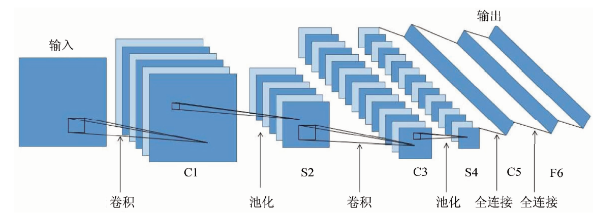
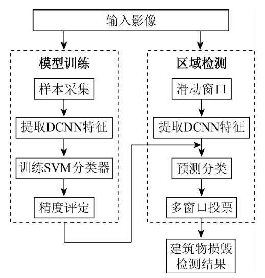
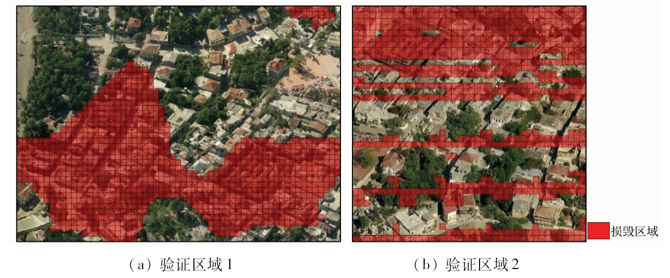
Abstract In order to improve the precision of damage assessment of post-earthquake buildings based on remote sensing images, this paper introduces a deep convolutional neural network (DCNN) model that performs well in natural image classification and target detection, and also proposes a method of using DCNN fully-connected layer features combined with support vector machine (SVM) to detect damaged building areas in remote sensing images. Firstly, neural network feed forward is used to extract the features of the training samples and the regions to be detected from the DCNN fully-connected layer; then the SVM classifier is learned based on the training samples; finally, all the blocks in the detection region are subjected to predicting and voting to determine whether they are damaged. The authors used Haiti earthquake remote sensing imagery in 2010 to do verification. The accuracy rate of damage detection in this method can reach 89%. Compared with the traditional feature extraction method, the correct rate is improved by 4%. The experimental results show that this method has a certain potential in the detection of building damage damage.
|
| Keywords
damaged building
convolutional neural network
SVM
high-resolution remote sensing image
|
|
|
|
Corresponding Authors:
Yunsheng ZHANG
E-mail: zhangys@csu.edu.cn
|
|
Issue Date: 23 May 2019
|
|
|
| [1] |
Janalipour M, Mohammadzadeh A . Building damage detection using object-based image analysis and ANFIS from high-resolution image (Case study:BAM earthquake,Iran)[J]. IEEE Journal of Selected Topics in Applied Earth Observations and Remote Sensing, 2016,9(5):1937-1945.
doi: 10.1109/JSTARS.2015.2458582
url: http://ieeexplore.ieee.org/document/7182741/
|
| [2] |
郭华东, 鹿琳琳, 马建文 , 等. 一种改进的地震灾害倒塌房屋遥感信息自动识别方法[J]. 科学通报, 2009,54(17):2581-2585.
|
| [2] |
Guo H D, Lu L L, Ma J W , et al. An improved method for automatic recognition of remote sensing information of earthquake disasters with collapsed houses[J]. Chinese Science Bulletin, 2009,54(17):2581-2585.
|
| [3] |
叶昕, 王俊, 秦其明 . 基于高分一号卫星遥感图像的建筑物震害损毁检测研究——以2015年尼泊尔M_S8.1地震为例[J]. 地震学报, 2016,38(3):477-485.
|
| [3] |
Ye X, Wang J, Qin Q M . Building seismic damage detection research based on high-resolution satellite remote sensing images:A case study of Nepal M_S8.1 earthquake in 2015[J]. Journal of Seismology, 2016,38(3):477-485.
|
| [4] |
Yamazaki F, Suzuki D, Maruyama Y. Detection of damages due to earthquakes using digital aerial images [C]//The 14th World Conference on Earthquake Engineering, 2008.
|
| [5] |
Ehrlich D, Bielski C. Texture based change detection of built-up on SPOT panchromatic imagery using PCA [C]//Urban Remote Sensing Event.IEEE, 2011: 77-80.
|
| [6] |
于海洋, 程钢, 张育民 , 等. 基于LiDAR和航空影像的地震灾害倒塌建筑物信息提取[J]. 国土资源遥感, 2011,23(3):77-81.doi: 10.6046/gtzyyg.2011.03.14.
doi: 10.6046/gtzyyg.2011.03.14
|
| [6] |
Yu H Y, Cheng G, Zhang Y M , et al. Earthquake disaster collapse building information extraction based on LiDAR and aerial images[J]. Remote Sensing for Land and Resources, 2011,23(3):77-81.doi: 10.6046/gtzyyg.2011.03.14.
|
| [7] |
董燕生, 潘耀忠, 方伟华 , 等. 基于面向对象技术的建筑物震害识别方法研究[J]. 地震研究, 2011,34(3):372-377.
|
| [7] |
Dong Y S, Pan Y Z, Fang W H , et al. Research on building earthquake damage identification method based on object-oriented technology[J]. Earthquake Research, 2011,34(3):372-377.
|
| [8] |
王岩, 王晓青, 窦爱霞 . 面向对象遥感分类方法在汶川地震震害提取中的应用[J]. 地震, 2009,29(3):54-60.
|
| [8] |
Wang Y, Wang X Q, Dou A X . Application of object-oriented remote sensing classification method in seismic damage extraction of Wenchuan earthquake[J]. Earthquake, 2009,29(3):54-60.
|
| [9] |
王慧敏, 李艳 . 面向对象的损毁建筑物提取[J].遥感信息, 2011 (5):81-85.
|
| [9] |
Wang H M, Li Y . Object-oriented damaged building extraction[J].Remote Sensing Information, 2011 (5):81-85.
|
| [10] |
刘宇, 曹国, 周丽存 , 等. 基于多特征结合的损毁建筑物检测[J]. 计算机应用, 2015,35(9):2652-2655.
doi: 10.11772/j.issn.1001-9081.2015.09.2652
|
| [10] |
Liu Y, Cao G, Zhou L C , et al. Damaged building detection based on multi-features combination[J]. Computer Application, 2015,35(9):2652-2655.
|
| [11] |
许夙晖, 慕晓冬, 赵鹏 , 等. 利用多尺度特征与深度网络对遥感影像进行场景分类[J]. 测绘学报, 2016,45(7):834-840.
|
| [11] |
Xu S H, Mu X D, Zhao P , et al. Multi-scale feature and deep network for scene classification of remote sensing images[J]. Journal of Surveying and Mapping, 2016,45(7):834-840.
|
| [12] |
Hu F, Xia G S, Hu J , et al. Transferring deep convolutional neural networks for the scene classification of high-resolution remote sensing imagery[J]. Remote Sensing, 2015,7(11):14680-14707.
doi: 10.3390/rs71114680
url: http://www.mdpi.com/2072-4292/7/11/14680
|
| [13] |
Zhou W, Newsam S, Li C , et al. Learning low dimensional convolutional neural networks for high-resolution remote sensing image retrieval[J]. Remote Sensing, 2017,9(5):489.
doi: 10.3390/rs9050489
url: http://www.mdpi.com/2072-4292/9/5/489
|
| [14] |
Vetrivel A, Gerke M, Kerle N , et al. Disaster damage detection through synergistic use of deep learning and 3D point cloud features derived from very high resolution oblique aerial images,and multiple-kernel-learning[J]. ISPRS Journal of Photogrammetry and Remote Sensing, 2017,140:45-59.
|
| [15] |
李奇峰 . 结合多特征描述和SVM的遥感影像分类研究[D]. 郑州:郑州大学, 2015.
|
| [15] |
Li Q F . Research on Remote Sensing Image Classification Based on Multiple Feature Description and SVM[D]. Zhengzhou:Zhengzhou University, 2015.
|
| [16] |
王旭东, 段福洲, 屈新原 , 等. 面向对象和SVM结合的无人机数据建筑物提取[J]. 国土资源遥感, 2017,29(1):97-103.doi: 10.6046/gtzyyg.2017.01.15.
|
| [16] |
Wang X D, Duan F Z, Qu X Y , et al. UAV data architecture extraction combined with object-oriented and SVM[J]. Remote Sensing for Land and Resources, 2017,29(1):97-103.doi: 10.6046/gtzyyg.2017.01.15.
|
| [17] |
张峰, 薛艳丽, 李英成 , 等. 基于SVM的多源遥感影像面向对象建筑物提取方法[J]. 国土资源遥感, 2008,20(2):27-29.doi: 10.6046/gtzyyg.2008.02.07.
doi: 10.6046/gtzyyg.2008.02.07
|
| [17] |
Zhang F, Xue Y L, Li Y C , et al. Multi-source remote sensing image-based object-oriented building extraction method based on SVM[J]. Remote Sensing for Land and Resources, 2008,20(2):27-29.doi: 10.6046/gtzyyg.2008.02.07.
|
| [18] |
Dalal N, Triggs B. Histograms of oriented gradients for human detection [C]//2005 IEEE Computer Society Conference on Computer Vision and Patter Recognition, 2005: 886-893.
|
| [19] |
Simonyan K , Zisserman A .Very deep convolutional networks for large-scale image recognition[EB/OL]..
url: https://arxiv.org/pdf/1409.1556.pdf
|
| [20] |
Penatti O A B, Nogueira K, Santos J A D. Do deep features generalize from everyday objects to remote sensing and aerial scenes domains? [C]//Computer Vision and Pattern Recognition Workshops.IEEE, 2015: 44-51.
|
| [21] |
Wang J, Luo C, Huang H , et al. Transferring pre-trained deep CNNs for remote scene classification with general features learned from linear PCA network[J]. Remote Sensing, 2017,9(3):225.
doi: 10.3390/rs9030225
url: http://www.mdpi.com/2072-4292/9/3/225
|
| [22] |
Cortes C, Vapnik V N . Support-vector networks[J]. Machine Learning, 1995,20(3):273-297.
|
| [23] |
Xia G S, Hu J, Hu F , et al. AID:A benchmark data set for performance evaluation of aerial scene classification[J]. IEEE Transactions on Geoscience and Remote Sensing, 2017,55(7):3965-3981.
doi: 10.1109/TGRS.2017.2685945
url: http://ieeexplore.ieee.org/document/7907303/
|
|
Viewed |
|
|
|
Full text
|
|
|
|
|
Abstract
|
|
|
|
|
Cited |
|
|
|
|
| |
Shared |
|
|
|
|
| |
Discussed |
|
|
|
|
 2019,
Vol. 31
2019,
Vol. 31
 ), Siyang CHEN, Zhengrong ZOU, Yaochen ZHU, Ruixue ZHAO