|
|
 |
|

|
|
|
Reconstruction of land surface temperature time-series datasets of FY-2F based on Savitzky-Golay filter |
Di WU1, Jian CHEN1( ), Man SHI1, Bangyong QIN2, Shengyang LI2 ), Man SHI1, Bangyong QIN2, Shengyang LI2 |
1.School of Remote Sensing and Surveying Engineering, Nanjing University of Information Science and Technology, Nanjing 210044, China
2.Key Laboratory of Space Utilization, Technology and Engineering Center for Space Utilization, Chinese Academy of Sciences, Beijing 100094, China |
|
|
|
|
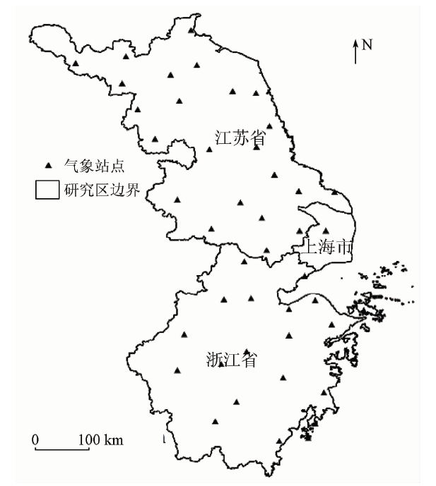
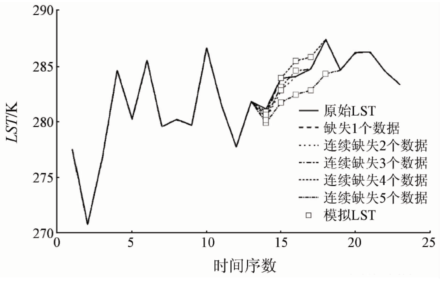
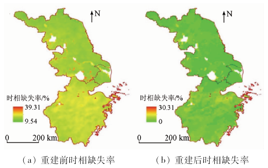
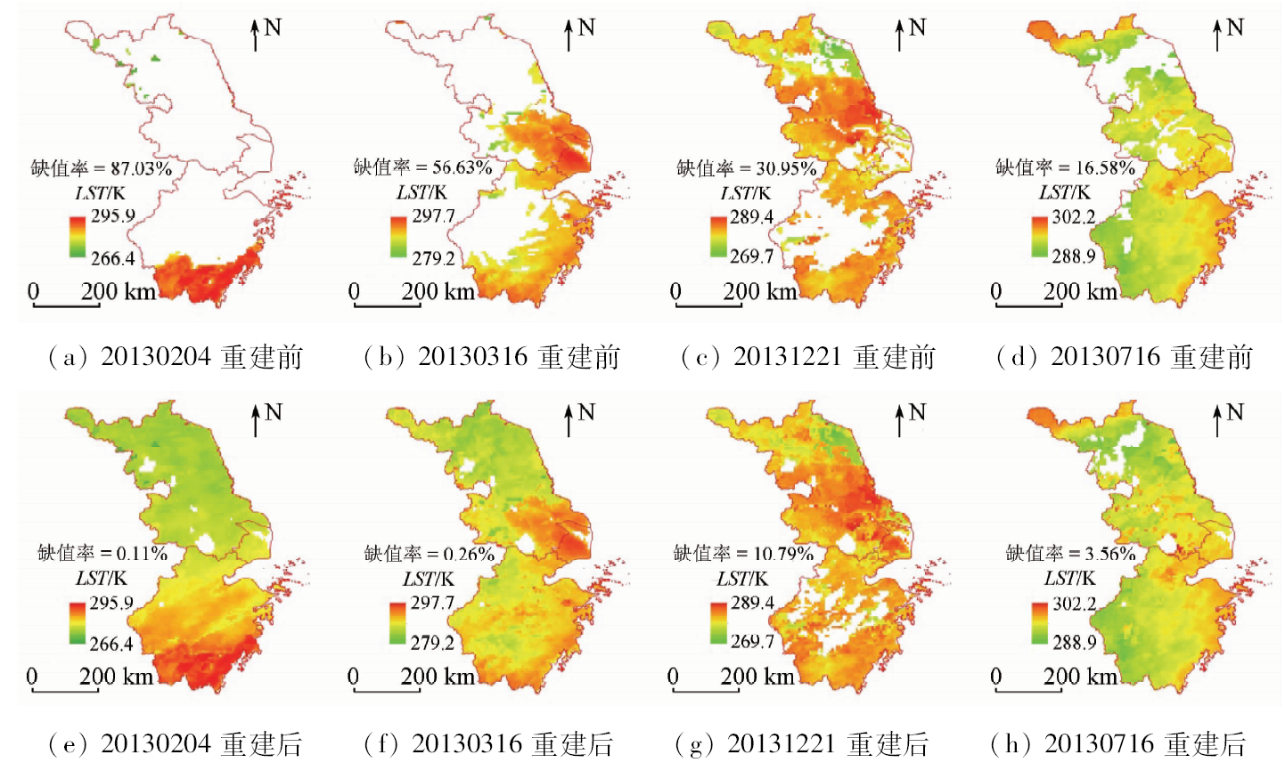
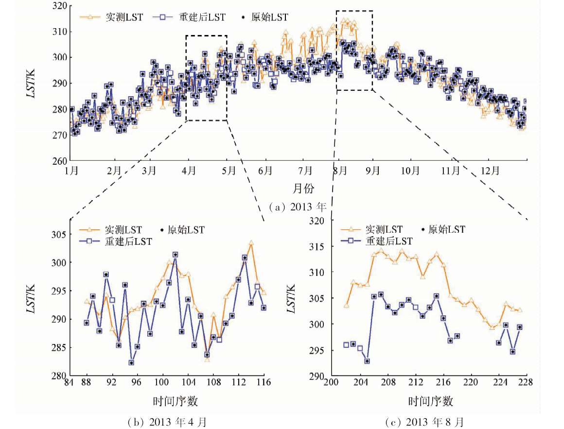
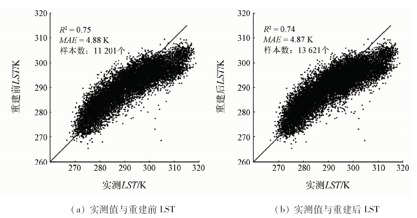
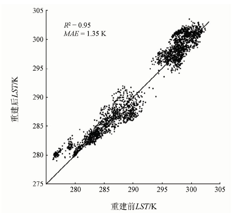
Abstract Regional and spatial continuous land surface temperature (LST) can be retrieved from satellite remote sensing data, and has an important significance in such fields as global change, ecology, environment, and agricultural production. However, the LST retrieved by remote sensing usually has missing data in time and space due to the influence of clouds, aerosols, satellite viewing angle and solar illumination angle, which limits the application of LST products. In this paper, the authors reconstructed FY-2F daily LST data of 2013 in the Yangtze River delta region using Savitzky-Golay (S-G) filter based on the characteristics of long time-series LST. The results show that S-G filter can fill the missing values effectively and ensure the spatial distribution consistency of the LST after reconstruction. The average time-series loss rate of the original FY-2F LST product is 19.43%, and then decreases to 1.69% after S-G filtering. In order to verify the reconstruction accuracy of S-G filter, the authors randomly selected some regions that are not deficient, and then made comparison with the results after S-G filtering. It is proved that S-G filter reconstructing method has obtained high accuracy, with the mean absolute error 1.35 K and the fitting accuracy 0.95. Higher quality and long time-series FY-2F LST which is reconstructed based on S-G filter offers a good foundation to the study of temporal and spatial distribution of further thermal environment.
|
| Keywords
land surface temperature
Savitzky-Golay(S-G) filter
time-series
FY-2F
reconstruction
|
|
|
|
Corresponding Authors:
Jian CHEN
E-mail: chjnjnu@163.com
|
|
Issue Date: 23 May 2019
|
|
|
| [1] |
Dash P, Göttsche F M, Olesen F S , et al. Land surface temperature and emissivity estimation from passive sensor data:Theory and practice-current trends[J]. International Journal of Remote Sensing, 2002,23(13):2563-2594.
doi: 10.1080/01431160110115041
url: https://www.tandfonline.com/doi/full/10.1080/01431160110115041
|
| [2] |
周芳成, 宋小宁, 李召良 . 地表温度的被动微波遥感反演研究进展[J]. 国土资源遥感, 2014,26(1):1-7.doi: 10.6046/gtzyyg.2014.01.01.
doi: 10.6046/gtzyyg.2014.01.01
|
| [2] |
Zhou F C, Song X N, Li Z L . Progress of land surface temperature retrieval based on passive microwave remote sensing[J]. Remote Sensing for Land and Resources, 2014,26(1):1-7.doi: 10.6046/gtzyyg.2014.01.01.
|
| [3] |
李天祺, 朱秀芳, 潘耀忠 , 等. MODIS陆地表面温度数据重构方法研究[J]. 北京师范大学学报(自然科学版), 2015,51(s1):70-76.
|
| [3] |
Li T Q, Zhu X F, Pan Y Z , et al. Study on reconstruction methods of MODIS LST products[J]. Journal of Beijing Normal University (Natural Science), 2015,51(s1):70-76.
|
| [4] |
祝善友, 张桂欣 . 近地表气温遥感反演研究进展[J]. 地球科学进展, 2011,26(7):724-730.
doi: 10.11867/j.issn.1001-8166.2011.07.0724
url: http://d.wanfangdata.com.cn/Periodical/dqkxjz201107005
|
| [4] |
Zhu S Y, Zhang G X . Progress in near surface air temperature retrieved by remote sensing technology[J]. Advances in Earth Science, 2011,26(7):724-730.
|
| [5] |
Wan Z, Zhang Y, Zhang Q , et al. Validation of the land-surface temperature products retrieved from Terra moderate resolution imaging spectroradiometer data[J]. Remote Sensing of Environment, 2002,83(1-2):163-180.
doi: 10.1016/S0034-4257(02)00093-7
url: https://linkinghub.elsevier.com/retrieve/pii/S0034425702000937
|
| [6] |
涂丽丽, 覃志豪, 张军 , 等. 基于空间内插的云下地表温度估计及精度分析[J].遥感信息, 2011(4):59-63.
|
| [6] |
Tu L L, Qin Z H, Zhang J , et al. Estimation and error analysis of land surface temperature under the cloud based on spatial interpolation[J].Remote Sensing Information, 2011(4):59-63.
|
| [7] |
李儒, 张霞, 刘波 , 等. 遥感时间序列数据滤波重建算法发展综述[J]. 遥感学报, 2009,13(2):335-341.
doi: 10.3321/j.issn:1007-4619.2009.02.023
url: http://d.wanfangdata.com.cn/Periodical/ygxb200902023
|
| [7] |
Li R, Zhang X, Liu B , et al. Review on methods of remote sensing time-series data reconstruction[J]. Journal of Remote Sensing, 2009,13(2):335-341.
|
| [8] |
边金虎, 李爱农, 宋孟强 , 等. MODIS植被指数时间序列Savitzky-Golay滤波算法重构[J]. 遥感学报, 2010,14(4):725-741.
|
| [8] |
Bian J H, Li A N, Song M Q , et al. Reconstruction of NDVI time-series datasets of MODIS based on Savitzky-Golay filter[J]. Journal of Remote Sensing, 2010,14(4):725-741.
|
| [9] |
Nguyen O V, Kawamura K, Trong D P , et al. Temporal change and its spatial variety on land surface temperature and land use changes in the Red River Delta,Vietnam,using MODIS time-series imagery[J]. Environmental Monitoring and Assessment, 2015,187(7):1-11.
doi: 10.1007/s10661-014-4167-x
url: http://link.springer.com/10.1007/s10661-014-4167-x
|
| [10] |
Neteler M . Estimating daily land surface temperatures in mountainous environments by reconstructed MODIS LST data[J]. Remote Sensing, 2010,2(1):333-351.
doi: 10.3390/rs1020333
url: http://www.mdpi.com/2072-4292/2/1/333
|
| [11] |
臧琳, 宋冬梅, 甘宇亮 , 等. 统计模型与滤波算法的地表温度重建方法探讨[J]. 测绘科学, 2016,41(7):11-17.
|
| [11] |
Zang L, Song D M, Gan Y L , et al. Study on reconstruction of LST based on the statistical model and filtering algorithm[J]. Science of Surveying and Mapping, 2016,41(7):11-17.
|
| [12] |
韩冬锐, 徐新良, 李静 , 等. 长江三角洲城市群热环境安全格局及土地利用变化影响研究[J]. 地球信息科学学报, 2017,19(1):39-49.
|
| [12] |
Han D R, Xu X L, Li J , et al. Study on the security pattern of the heat environment and the influence of land use change in the Yangtze River Delta urban agglomeration[J]. Journal of Geo-Information Science, 2017,19(1):39-49.
|
| [13] |
Ooka R . Recent development of assessment tools for urban climate and heat-island investigation especially based on experiences in Japan[J]. International Journal of Climatology, 2007,27(14):1919-1930.
doi: 10.1002/(ISSN)1097-0088
url: http://doi.wiley.com/10.1002/%28ISSN%291097-0088
|
| [14] |
姚远, 陈曦, 钱静 . 城市地表热环境研究进展[J]. 生态学报, 2018,38(3):1134-1147.
|
| [14] |
Yao Y, Chen X, Qian J . Research progress on the thermal environment of the urban surfaces[J]. Acta Ecologica Sinica, 2018,38(3):1134-1147.
|
| [15] |
Savitzky A , Golay M J E .Smoothing and differentiation of data by simplified least squares procedures[J]. Analytical Chemistry, 1964,36(8):1627-1639.
doi: 10.1021/ac60214a047
url: http://pubs.acs.org/doi/abs/10.1021/ac60214a047
|
| [16] |
Chen J, Jonsson P, Tamura M , et al. A simple method for reconstructing a high-quality NDVI time-series data set based on the Savitzky-Golay filter[J]. Remote Sensing of Environment, 2004,91(3-4):332-334.
doi: 10.1016/j.rse.2004.03.014
url: https://linkinghub.elsevier.com/retrieve/pii/S003442570400080X
|
| [17] |
权文婷, 周辉, 李红梅 , 等. 基于S-G滤波的陕西关中地区冬小麦生育期遥感识别和长势监测[J]. 中国农业气象, 2015,36(1):93-99.
doi: 10.3969/j.issn.1000-6362.2015.01.012
|
| [17] |
Quan W T, Zhou H, Li H M , et al. Remote recognition and growth monitoring of winter wheat in key stages based on S-G filter in Guanzhong region[J]. Chinese Journal of Agrometeorology, 2015,36(1):93-99.
|
| [18] |
陈顺云, 刘培洵, 刘力强 , 等. 遥感与实测地表温度的对比分析及在地震研究中的意义[J]. 地球物理学报, 2011,54(3):747-755.
doi: 10.3969/j.issn.0001-5733.2011.03.014
|
| [18] |
Chen S Y, Liu P X, Liu L Q , et al. Comparative analysis between land surface temperatures obtained by field measurement and satellite remote sensing and its implication in earthquake research[J]. Chinese Journal of Geophysics, 2011,54(3):747-755.
|
| [19] |
杨贵军, 孙晨红, 历华 . 黑河流域ASTER与MODIS融合生成高分辨率地表温度的验证[J]. 农业工程学报, 2015,31(6):193-200.
|
| [19] |
Yang G J, Sun C H, Li H . Verification of high-resolution land surface temperature by blending ASTER and MODIS data in Heihe River Basin[J]. Transactions of the Chinese Society of Agricultural Engineering, 2015,31(6):193-200.
|
|
Viewed |
|
|
|
Full text
|
|
|
|
|
Abstract
|
|
|
|
|
Cited |
|
|
|
|
| |
Shared |
|
|
|
|
| |
Discussed |
|
|
|
|
 2019,
Vol. 31
2019,
Vol. 31