|
|
 |
|

|
|
|
Improvement and application of forced invariance vegetation suppression in southern vegetation area |
| Zhan YIN1, Lijun ZHANG2, Jianliang DUAN1, Pei ZHANG1 |
1.China Non-Ferrous Metals Resource Geological Survey, Beijing 100012, China
2.Research Institute of Hunan Provincial Nonferrous Metals Geological Exploration Bureau, Changsha 410083, China |
|
|
|
|
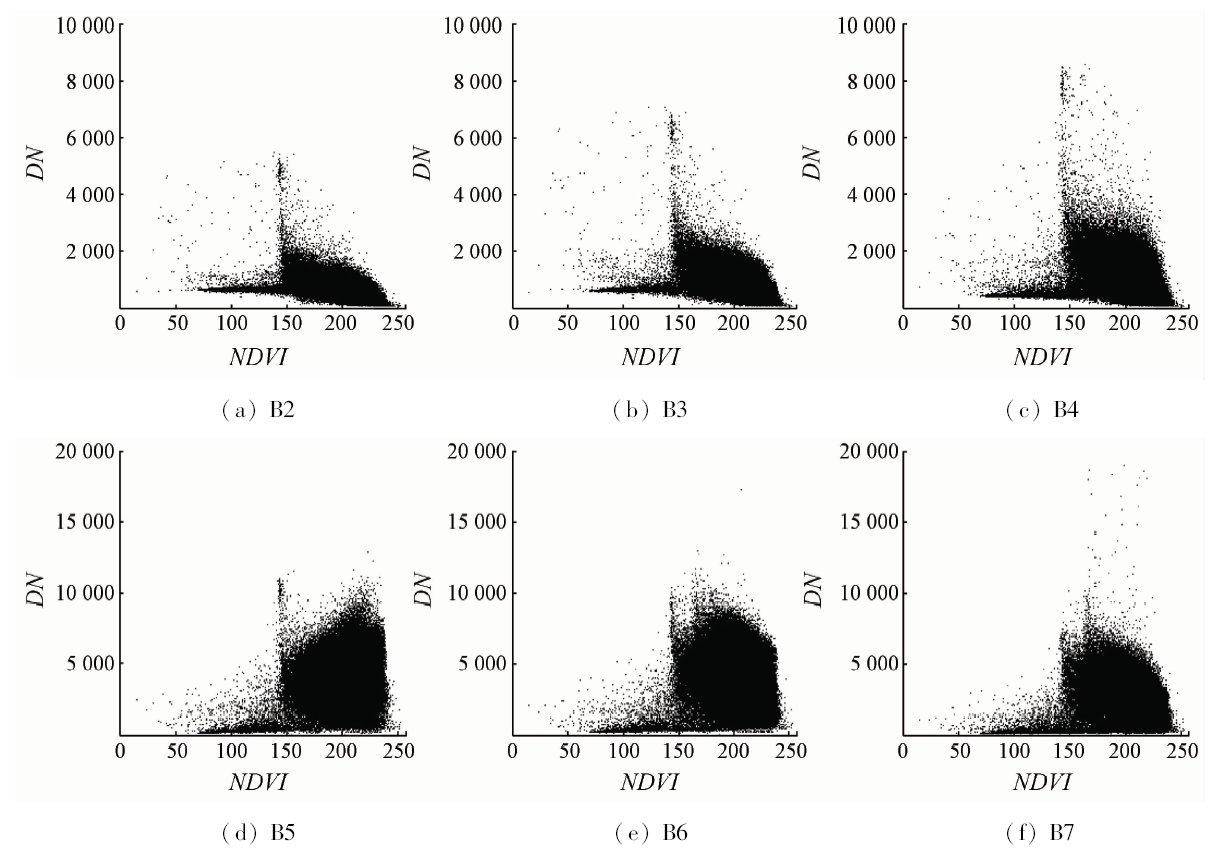
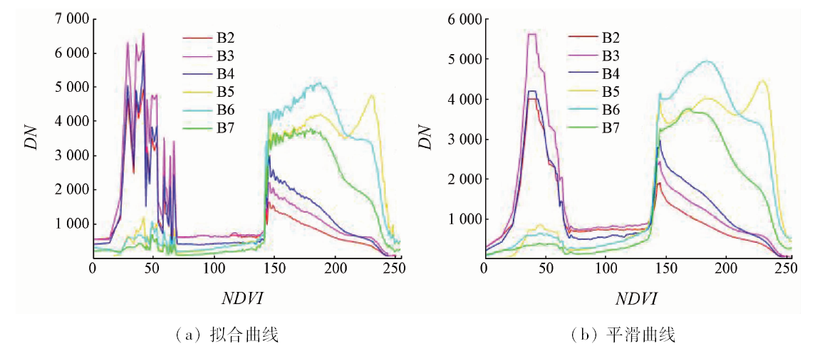
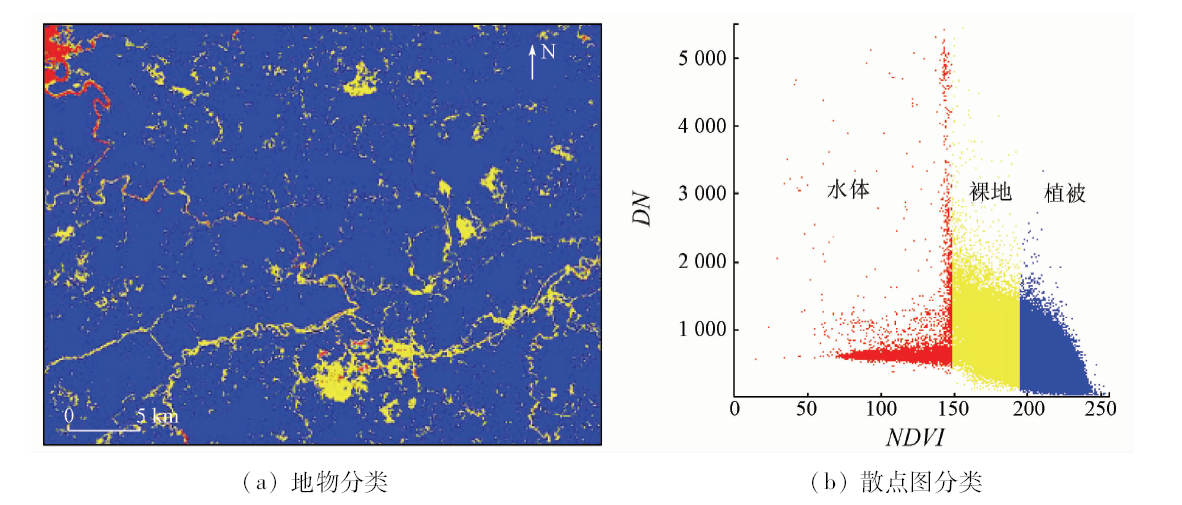
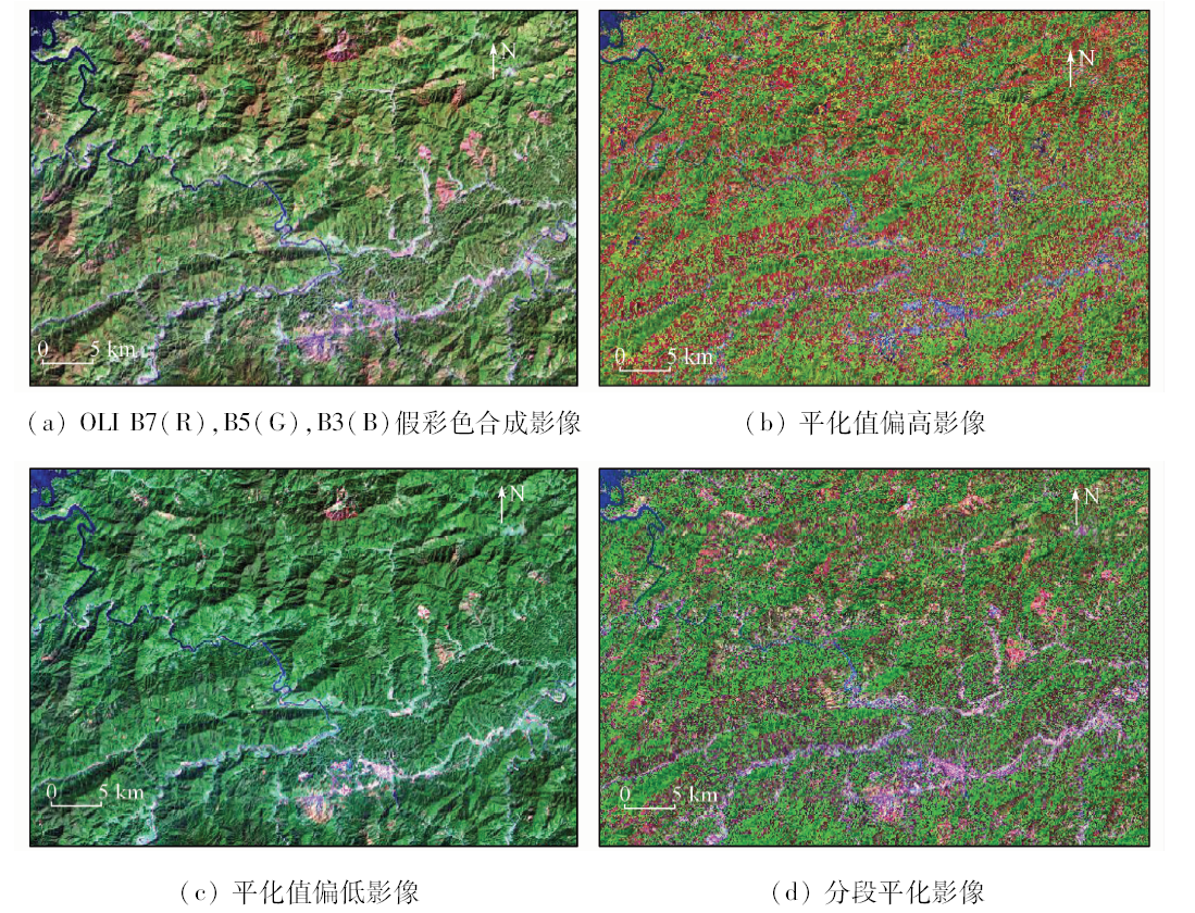
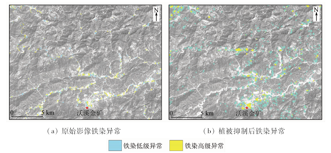
Abstract Vegetation cover causes great interference in rock alteration information extraction. Forcing invariant vegetation suppression technology has achieved good vegetation suppression effect in semi-arid and open terrain area, but the effect remains to be verified in mountainous areas where vegetation is flourishing. Based on the forcing invariant vegetation suppression technology, in the southern vegetation area, the subsection leveling and programming are implemented in the key technical curve leveling steps, which can solve the contradiction between vegetation suppression, color deviation in bare land and information integrity. The vegetation information after subsection leveling is well suppressed, and the underlying bedrock information is prominent and the tone is natural. By using this method to extract remote sensing alteration information, the vegetation area’s remote sensing anomaly is obviously enhanced, the anomaly agrees well with the actual wall rock alteration, and the effect is better.
|
| Keywords
forced invariance
vegetation suppression
subsection leveling
alteration information extraction
southern vegetation area
|
|
|
|
Issue Date: 23 May 2019
|
|
|
| [1] |
Chen S B, Liu Y L, Qian Y , et al. Lithologic classification from hyperspectral data in dense vegetation cover area[J]. Journal of Jilin University, 2012,42(6):1959-1965.
|
| [2] |
沈利霞, 刘丽萍, 苏新旭 , 等. 不同植被覆盖率地区遥感矿化蚀变提取研究[J]. 现代地质, 2008,22(2):293-298.
|
| [2] |
Shen L X, Liu L P, Su X X , et al. Study on identification of altered wall-rock in areas of different vegetation coverages based on remote sensing[J]. Geoscience, 2008,22(2):293-298.
|
| [3] |
陈劲松 . 基于ETM+影像的矿化蚀变区植被信息提取研究[J]. 遥感技术与应用, 2013,28(6):1083-1087.
|
| [3] |
Chen J S . Study on the extraction of vegetation in mineralized alteration zone based on the ETM+ image[J]. Remote Sensing Technology and Application, 2013,28(6):1083-1087.
|
| [4] |
路轩轩, 朱谷昌, 邹林 , 等. 植被覆盖区的遥感蚀变信息提取研究——以老挝南部某金矿区为例[J]. 遥感信息, 2014,29(5):85-89.
|
| [4] |
Lu X X, Zhu G C, Zou L , et al. The extraction of alteration information with remote sensing image of vegetation coverage area:A case study of the gold mine in southern Laos[J]. Remote Sensing Information, 2014,29(5):85-89.
|
| [5] |
马超飞, 刘红素, 蔺启忠 . 专题信息提取中降低植被影像的处理方法研究[J]. 遥感技术与应用, 1998,13(4):9-13.
|
| [5] |
Ma C F, Liu H S, Lin Q Z . Study on processing methods for reducing vegetation effect in extracting thematic information[J]. Remote Sensing Technology and Application, 1998,13(4):9-13.
|
| [6] |
Kitamoto A, Takagi M . Image classification using probabilistic models that reflect the internal structure of mixels[J]. Pattern Analysis and Applications, 1999,2(1):31-43.
doi: 10.1007/s100440050012
url: http://link.springer.com/10.1007/s100440050012
|
| [7] |
Bierwirth P N . Mineral mapping and vegetation removal via data-calibrated pixel unmixing using multispectral images[J]. International Journal of Remote Sensing, 1990,11(11):1999-2017.
doi: 10.1080/01431169008955157
url: https://www.tandfonline.com/doi/full/10.1080/01431169008955157
|
| [8] |
刘成, 王丹丽, 李笑梅 . 用混合像元线性模型提取中等植被覆盖区的粘土蚀变信息[J]. 遥感技术与应用, 2003,18(20):95-98.
|
| [8] |
Liu C, Wang D L, Li X M . Extracting clay alteration information of medium vegetation covered areas based on linear model of spectral mixture analysis[J]. Remote Sensing Technology and Application, 2003,18(20):95-98.
|
| [9] |
陈勇敢, 韩先菊, 张慧玉 , 等. 基于混合像元分解提取多种类覆盖区遥感蚀变信息——以甘肃省岷县寨上金矿区为例[J]. 地质与勘探, 2011,47(6):1171-1176.
|
| [9] |
Chen Y G, Han X J, Zhang H Y , et al. Extracting remote sensing alteration information from areas with various covers based on decomposition of mixed pixels:An example of the Zhaishang gold mine in Min County of Gansu Province[J]. Geology and Exploration, 2011,47(6):1171-1176.
|
| [10] |
Crippen R E, Blom R G . Unveiling the lithology of vegetated terrains in remotely sensed imagery[J]. Photogrammetric Engineering and Remote Sensing, 2001,67(8):935-946.
|
| [11] |
俞乐, 章钦瑜, 朱骏 , 等. 光学遥感图像植被信息抑制通用方法[J]. 国土资源遥感, 2011,23(2):38-42.doi: 10.6046/gtzyyg.2011.02.07.
doi: 10.6046/gtzyyg.2011.02.07
|
| [11] |
Yu L, Zhang Q Y, Zhu J , et al. A general approach for suppressing vegetation in optical remotely sensed imagery[J]. Remote Sensing for Land and Resources, 2011,23(2):38-42.doi: 10.6046/gtzyyg.2011.02.07.
|
| [12] |
Yu L, Porwal A, Holden E J , et al. Suppression of vegetation in multispectral remote sensing images[J]. International Journal of Remote Sensing, 2011,32(22):7343-7357.
doi: 10.1080/01431161.2010.523726
url: https://www.tandfonline.com/doi/full/10.1080/01431161.2010.523726
|
| [13] |
李苗苗 . 植被覆盖度的遥感估算方法研究[D]. 北京:中国科学院遥感应用研究所, 2003.
|
| [13] |
Li M M . The Method of Vegetation Fraction Estimation by Remote Sensing[D].Beijing:Institute of Remote Sensing Applications, Chinese Academy of Sciences, 2003.
|
| [14] |
何雅枫, 花立民, 邸利 . 不同植被指数反映地表植被覆盖度的比较分析——以甘肃河西走廊地区为例[J]. 中国农学通报, 2014,30(19):45-50.
|
| [14] |
He Y F, Hua L M, Di L . Comparative analysis on the reflection effect of the vegetation on the earth’s surface by different vegetation indices:A case study in Hexi Corridor[J]. Chinese Agricultural Science Bulletin, 2014,30(19):45-50.
|
| [15] |
彭南海, 黄德志, 辛宇佳 , 等. 湘西沃溪金锑钨矿床流体包裹体特征及矿床成因[J]. 中国有色金属学报, 2013,23(9):2605-2612.
|
| [15] |
Peng N H, Huang D Z, Xin Y J , et al. Characteristics of fluid inclusions and genesis of Woxi Au-Sb-W deposit in western Hunan,China[J]. The Chinese Journal of Nonferrous Metals, 2013,23(9):2605-2612.
|
| [16] |
孙玉珍 . 沃溪金锑钨矿床围岩退色化蚀变的指示意义[J]. 采矿技术, 2013,13(6):143-144.
|
| [16] |
Sun Y Z . Indication significance of decoloration and alteration of surrounding rock of Woxi Au-Sb-W deposit[J]. Mining Technology, 2013,13(6):143-144.
|
|
Viewed |
|
|
|
Full text
|
|
|
|
|
Abstract
|
|
|
|
|
Cited |
|
|
|
|
| |
Shared |
|
|
|
|
| |
Discussed |
|
|
|
|
 2019,
Vol. 31
2019,
Vol. 31