|
|
 |
|

|
|
|
Research on the geospatial correction method of water extracting products considering the characteristics of time points |
| Tao CHENG, Guangyong LI, Kai BI |
| National Geomatics Center of China, Beijing 100830, China |
|
|
|
|
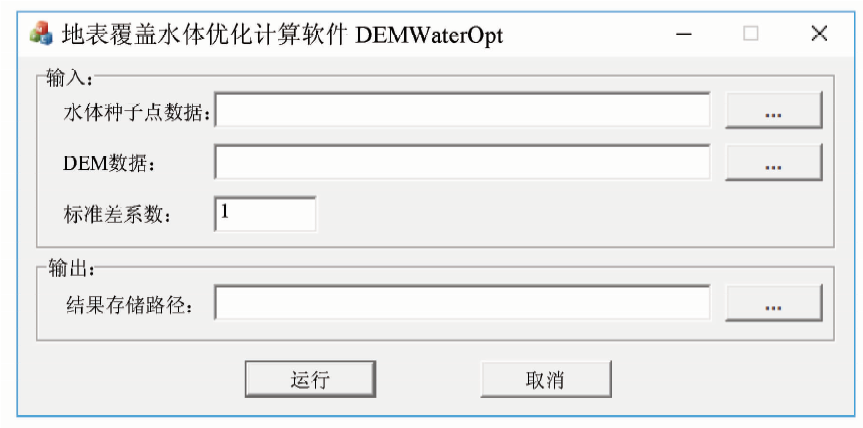
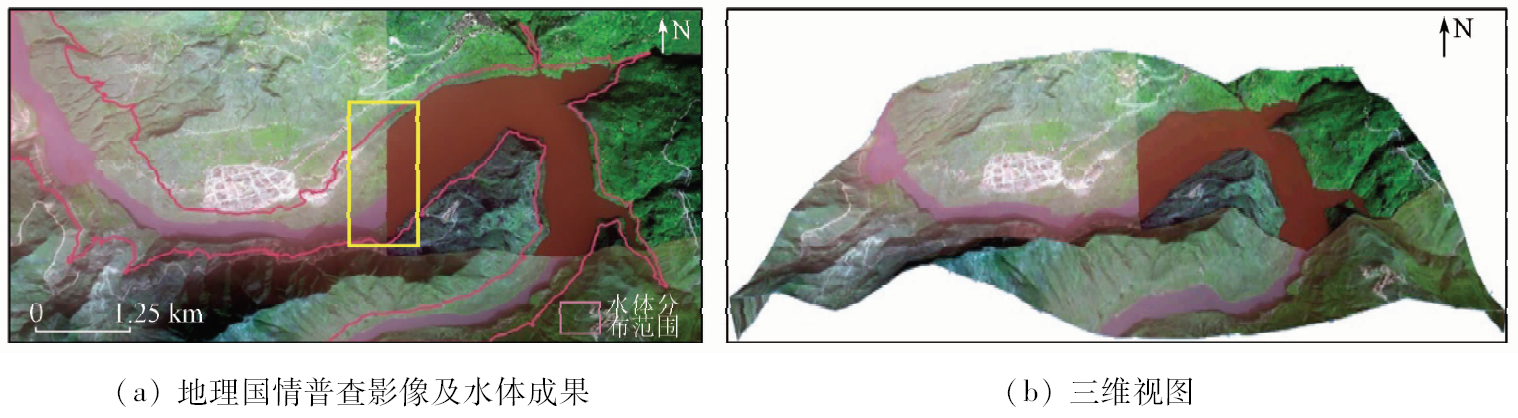
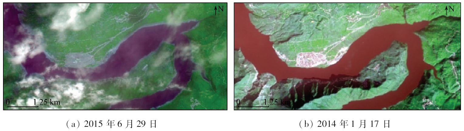
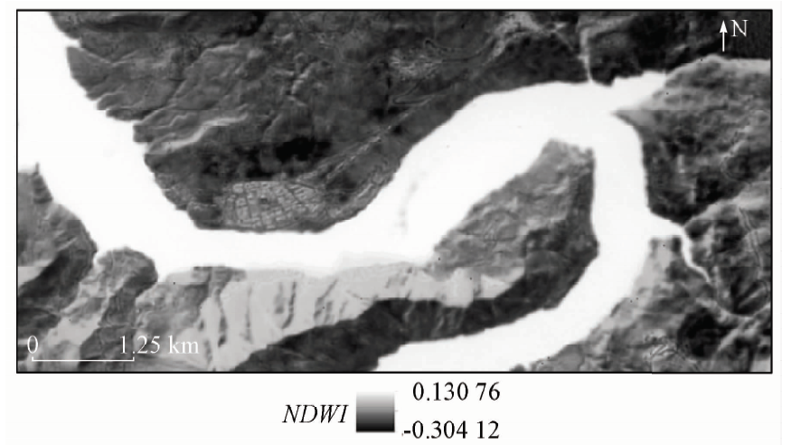
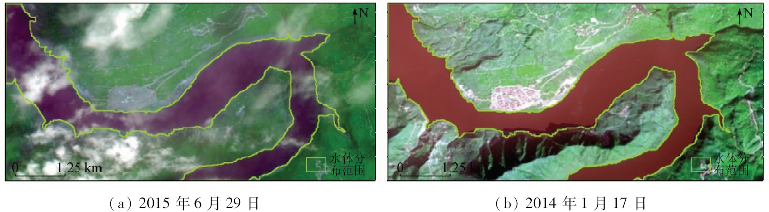
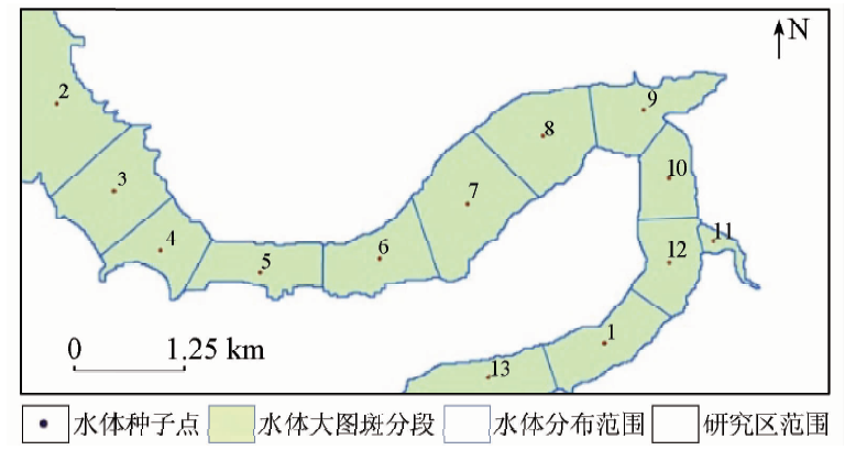
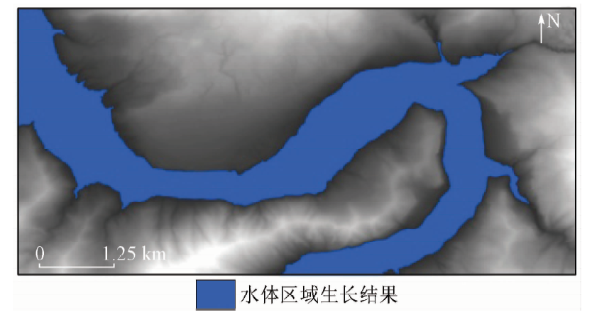
Abstract The water extracting has the characteristics of time point effects. In view of the objective status of seasonal variation of land water, a method of geospatial correction for water extracting products is proposed. Firstly, the water land cover information is extracted based on high time resolution remote sensing image to ensure that the timeliness meets the standard time point. Then the result is used as a prior knowledge, and the refined water land cover information is extracted based on fine grid DEM data by using region growing algorithm of water seeds, whose accuracy is optimized to the high spatial resolution level and can meet the requirement. On such a basis, it achieves geospatial correction of water extracting products. With the first national geographic conditions census as an example, the Landsat 8 images of 15 m spatial resolution were obtained to meet the standard time point of the study area. The water land cover distribution was extracted based on the NDWI index, and the 2 m grid DEM data were used to optimize the precision. The results show that the geographical spatial range of the study area was corrected by 17.97% compared with the image source’s scanning time, and geographical spatial range was optimized by 1.56% caused by the spatial resolution conversion. The research shows that this method can provide a reference for the geospatial correction in the water extraction based on remote sensing technology, and has certain practical application value in the case that the images do not meet the requirements of the standard time point.
|
| Keywords
water
time point
land cover
DEM
region growing
national geographic conditions census
|
|
|
|
Issue Date: 23 May 2019
|
|
|
| [1] |
张丽萍 . 自然资源学基本原理[M]. 北京: 科学出版社, 2010, 9-20.
|
| [1] |
Zhang L P. Basic Principle of Natural Resource Science[M]. Beijing: Science Press, 2010, 9-20.
|
| [2] |
国务院第二次全国土地调查领导小组办公室.第二次全国土地调查标准时点统一更新调查实施方案[EB/OL].(2011-1-4)[2018-4-23]. https://wenku.baidu.com/view/d414dfd73186bceb19e8bbd6.html.
|
| [2] |
Leading Group Office of China’s Second Land Survey of the State Council.Implementation scheme of standard time point unified updating of China’s second land survey[EB/OL]. (2011-1-4)[2018-4-23]. https://wenku.baidu.com/view/d414dfd73186bceb19e8bbd6.html.
|
| [3] |
国务院第三次全国土地调查领导小组办公室.第三次全国土地调查总体方案[EB/OL]. (2011-1-11)[2018-4-23]. http://www.mnr.gov.cn/gk/tzgg/201801/t20180111_1992830.html.
|
| [3] |
Leading Group Office of China’s Third Land Survey of the State Council.Overall plan of China’s third land survey[EB/OL]. (2011-1-11)[2018-4-23]. http://www.mnr.gov.cn/gk/tzgg/201801/t20180111_1992830.html.
|
| [4] |
中华人民共和国水利部,中华人民共和国国家统计局.第一次全国水利普查公报[EB/OL].(2013-3-21)[2018-4-23]. http://www.mwr.gov.cn/sj/tjgb/dycqgslpcgb/.
|
| [4] |
Ministry of Water Resources,P.R.China,National Bureau of Statistics,P.R.China.Bulletin of first national census for water.[EB/OL].(2013-3-21)[2018-4-23]. http://www.mwr.gov.cn/sj/tjgb/dycqgslpcgb/.
|
| [5] |
国务院第一次全国地理国情普查领导小组办公室. 地理国情普查内容与指标[S].北京: 测绘出版社, 2013.
|
| [5] |
Leading Group Office of China’s First National Geographic Conditions Census of the State Council. Contents and indexes of national geographic conditions census[S]. Beijing: Surveying and Mapping Press, 2013.
|
| [6] |
徐涵秋 . 利用改进的归一化差异水体指数(MNDWI)提取水体信息的研究[J]. 遥感学报, 2005,9(5):589-595.
doi: 10.3321/j.issn:1007-4619.2005.05.012
url: http://d.wanfangdata.com.cn/Periodical/ygxb200505012
|
| [6] |
Xu H Q . A study on information extraction of water body with the modified normalized difference water index(MNDWI)[J]. Journal of Remote Sensing, 2005,9(5):589-595.
|
| [7] |
程滔, 刘若梅, 周旭 . 基于高分辨率遥感影像的地理国情普查水体信息提取方法[J].测绘通报, 2014(4):86-89.
|
| [7] |
Cheng T, Liu R M, Zhou X . Water information extraction method in geographic national conditions investigation based on high resolution remote sensing images[J].Bulletin of Surveying and Mapping, 2014(4):86-89.
|
| [8] |
苏腾飞, 张圣微, 李洪玉 . 基于纹理特征与区域生长的高分辨率遥感影像分割算法[J]. 国土资源遥感, 2017,29(2):72-81.doi: 10.6046/gtzyyg.2017.02.11.
|
| [8] |
Su T F, Zhang S W, Li H Y . Segmentation algorithm based on texture feature and region growing for high-resolution remote sensing image[J]. Remote Sensing for Land and Resources, 2017,29(2):72-81.doi: 10.6046/gtzyyg.2017.02.11.
|
| [9] |
李修霞, 荆林海, 李慧 , 等. 参考1维光谱差异的区域生长种子点选取方法[J]. 中国图象图形学报, 2016,21(9):1256-1264.
|
| [9] |
Li X X, Jing L H, Li H , et al. Seed extraction method for seeded region growing based on one-dimensional spectral differences[J]. Journal of Image and Graphics, 2016,21(9):1256-1264.
|
| [10] |
宋坤, 刘锐宁, 李伟明 . Visual C++开发技术大全[M]. 北京: 人民邮电出版社, 2007: 74-86.
|
| [10] |
Song K, Liu R N, Li W M. Visual C++ Developing Technology[M]. Beijing: Posts and Telecom Press, 2007: 74-86.
|
| [11] |
李民录 . GDAL源码剖析与开发指南[M]. 北京: 人民邮电出版社, 2014: 31-34.
|
| [11] |
Li M L. GDAL Source Codes Analysis and Development Guide[M]. Beijing: Posts and Telecom Press, 2014: 31-34.
|
| [12] |
国务院第一次全国地理国情普查领导小组办公室.GDPJ 08—2013多尺度数字高程模型生产技术规定[EB/OL].(2014-3-13)[2018-4-23]. https://wenku.baidu.com/view/1d0541fef121dd36a32d8266.html.
|
| [12] |
Leading Group Office of China’s First National Geographic Conditions Census of the State Council.GDPJ 08—2013 production’s technology regulations of multiscale digital elevation model[EB/OL].(2014-3-13)[2018-4-23]. https://wenku.baidu.com/view/1d0541fef121dd36a32d8266.html.
|
|
Viewed |
|
|
|
Full text
|
|
|
|
|
Abstract
|
|
|
|
|
Cited |
|
|
|
|
| |
Shared |
|
|
|
|
| |
Discussed |
|
|
|
|
 2019,
Vol. 31
2019,
Vol. 31