|
|
 |
|

|
|
|
Retrieval of chlorophyll-a concentration in Chaohu based on radiative transfer model |
Wenya LIU1, Ruru DENG1,2,3( ), Yeheng LIANG1, Yi WU1, Yongming LIU1 ), Yeheng LIANG1, Yi WU1, Yongming LIU1 |
1.School of Geographic Science and Planning, Sun Yat-Sen University, Guangzhou 510275, China
2.Guangdong Engineering Research Center of Water Environment Remote Sensing Monitoring, Guangzhou 510275, China
3.Guangdong Provincial Key Laboratory of Urbanization and Geo-Simulation, Guangzhou 510275, China |
|
|
|
|
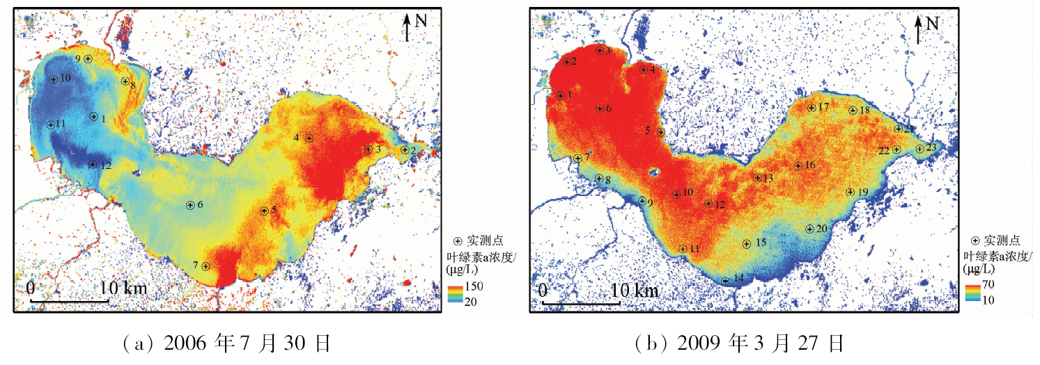
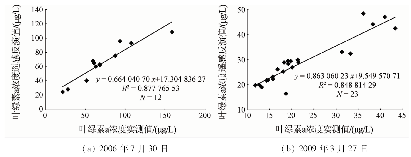
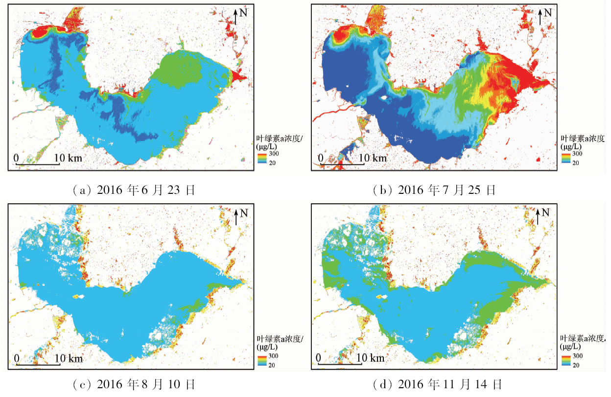
Abstract The algorithm of chlorophyll-a concentration inversion with higher universality is the key to improving the practicability of quantitative remote sensing technology. Based on the radioactive transfer mechanism, the optical characteristics of chlorophyll-a and other factors in inland lakes are analyzed, and a physical model of pixel reflectivity and factor concentration is established. The model was applied to the remote sensing data of different phases in Chaohu. The determination coefficient was 0.877 8 and the average relative error was only 11.61%. This proved that the precision of the model was higher and the universality was stronger. Then, the preprocessed Chaohu remote sensing image was applied to the model, and the spatial and temporal distribution characteristics of eutrophic pollution in Chaohu were obtained, which is consistent with the regulation of the seasonal multiplication of algae. The model used in this study has high accuracy and universality and thus can promote the application of quantitative remote sensing technology in water pollution research.
|
| Keywords
chlorophyll-a concentration
Landsat8
radiative transmission
Chaohu Lake
absorption
scattering
|
|
|
|
Corresponding Authors:
Ruru DENG
E-mail: esdrr@mail.sysu.edu.cn
|
|
Issue Date: 23 May 2019
|
|
|
| [1] |
余延年, 夏进 . 巢湖生态危机及其对策[J].水资源保护, 1989(1):48-53.
url: http://www.cqvip.com/QK/98577X/198901/3001461325.html
|
| [1] |
Yu Y N, Xia J . Chaohu ecological crisis and countermeasures[J].Water Resources Conservation, 1989(1):48-53.
|
| [2] |
李素菊, 吴倩, 王学军 , 等. 巢湖浮游植物叶绿素含量与反射光谱特征的关系[J]. 湖泊科学, 2002,14(3):228-234.
doi: 10.18307/2002.0306
url: http://www.cnki.com.cn/Article/CJFDTotal-FLKX200203005.htm
|
| [2] |
Li S J, Wu Q, Wang X J , et al. Correlations between reflectance spectra and contents of chlorophyll-a in Chaohu Lake[J]. Journal of Lake Science, 2002,14(3):228-234.
|
| [3] |
荀尚培, 翟武全, 范伟 , 等. MODIS巢湖水体叶绿素a浓度反演模型[J]. 应用气象学报, 2009,20(1):95-101.
doi: 10.11898/1001-7313.20090112
url: http://www.cnki.com.cn/Article/CJFDTotal-YYQX200901012.htm
|
| [3] |
Xun S P, Zhai W Q, Fan W , et al. MODIS in monitoring the chlorophyll-a concentrations of Chaohu Lake[J]. Journal of Applied Meteorological Science, 2009,20(1):95-101.
|
| [4] |
杨煜, 李云梅, 王桥 , 等. 基于环境一号卫星高光谱遥感数据的巢湖水体叶绿素a浓度反演[J]. 湖泊科学, 2010,22(4):495-503.
doi: 10.18307/2010.0404
url: http://www.cqvip.com/Main/Detail.aspx?id=34552863
|
| [4] |
Yang Y, Li Y M, Wang Q , et al. Retrieval of chlorophyll-a concentration by three-band model in Lake Chaohu[J]. Journal of Lake Science, 2010,22(4):495-503.
|
| [5] |
谢杰, 王心源, 张洁 , 等. 基于TM/ETM+影响分析巢湖叶绿素a浓度变化趋势[J]. 中国环境科学, 2010,30(5):677-682.
doi:
url: http://d.wanfangdata.com.cn/Periodical/zghjkx201005017
|
| [5] |
Xie J, Wang X Y, Zhang J , et al. Analysing developing trend of chlorophyll-a concentration in Chaohu Lake based on TM/ETM+ image[J]. China Environmental Science, 2010,30(5):677-682.
|
| [6] |
陈静, 吴传庆, 申维 , 等. 基于环境一号卫星CCD数据的巢湖叶绿素a的动态监测[J]. 中国环境监测, 2012,28(1):116-119.
doi: 10.3969/j.issn.1002-6002.2012.01.032
url: http://d.wanfangdata.com.cn/Periodical/zghjjc201201032
|
| [6] |
Chen J, Wu C Q, Shen W , et al. Chlorophyll-a dynamic monitoring in Chaohu Lake based on environmental satellite 1 CCD data[J]. Environmental Monitoring in China, 2012,28(1):116-119.
|
| [7] |
殷守敬, 吴传庆, 王晨 , 等. 综合遥感与地面观测的巢湖水体富营养化评价[J]. 中国环境监测, 2018,34(1):157-164.
doi: 10.19316/j.issn.1002-6002.2018.01.22
url: http://www.cnki.com.cn/Article/CJFDTotal-IAOB201801025.htm
|
| [7] |
Yin S J, Wu C Q, Wang C , et al. Eutrophication assessment of Chao-hu Lake using remote sensing and in-situ data[J]. Environmental Monitoring in China, 2018,34(1):157-164.
|
| [8] |
Gilerson A A, Gitelson A A, Zhou J , et al. Algorithms for remote estimation of chlorophyll-a in coastal and inland waters using red and near infrared bands[J]. Optics Express, 2010,18(23):24109-24125.
doi: 10.1364/OE.18.024109
pmid: 21164758
url: https://www.osapublishing.org/oe/abstract.cfm?uri=oe-18-23-24109
|
| [9] |
Matthews M W . A current review of empirical procedures of remote sensing in inland and near-coastal transitional waters[J]. International Journal of Remote Sensing, 2011,32(21):6855-6899.
doi: 10.1080/01431161.2010.512947
url: https://www.tandfonline.com/doi/full/10.1080/01431161.2010.512947
|
| [10] |
Mishra S, Mishra D R, Lee Z , et al. Quantifying cyanobacterial phycocyanin concentration in turbid productive waters:A quasi-analytical approach[J]. Remote Sensingof Environment, 2013,133:141-151.
doi: 10.1016/j.rse.2013.02.004
url: https://linkinghub.elsevier.com/retrieve/pii/S0034425713000448
|
| [11] |
Stumpf R P, Davis T W, Wynne T T , et al. Challenges for mapping cyanotoxin patterns from remote sensing of cyanobacteria[J]. Harmful Algae, 2016,54:160-173.
doi: 10.1016/j.hal.2016.01.005
pmid: 28073474
url: https://linkinghub.elsevier.com/retrieve/pii/S1568988315301839
|
| [12] |
邓孺孺, 何执兼, 陈晓翔 . 基于二次散射的水污染遥感模型及其在珠江口水域的应用[J]. 海洋学报, 2003,25(6):69-78.
|
| [12] |
Deng R R, He Z J, Chen X X . Model for water pollution remote sensing based on double scattering and its application on the Zhujiang River Estuary[J]. Acta Oceanologica Sinica, 2003,25(6):69-78.
|
| [13] |
邓孺孺, 秦雁 . 珠江三角洲水库水质遥感监测研究——以梅州水库和流溪河水库为例[ C]//全国国土资源与环境遥感应用技术研讨会论文集.深圳:中国国土经济学会, 2009: 179-188.
url: http://cpfd.cnki.com.cn/Article/CPFDTOTAL-BJCX200911001034.htm
|
| [13] |
Deng R R, Qin Y . Monitoring water quality of reservoirs in Pearl River Delta Region by remote sensing:A case study on Meizhou Reservoir and Liuxihe Reservoir[C]//Proceedings of the National Seminar on Remote Sensing Application Technology for Land and Resources and Environment.Shenzhen:Chinese Society of Territorial Economics, 2009: 179-188.
|
| [14] |
邓孺孺, 何执兼, 陈晓翔 , 等. 珠江口水域水污染遥感定量分析[J]. 中山大学学报(自然科学版), 2002,41(3):99-103.
doi: 10.3321/j.issn:0529-6579.2002.03.026
url: http://d.wanfangdata.com.cn/Periodical/zsdxxb200203026
|
| [14] |
Deng R R, He Z J, Chen X X , et al. Qualitative analysis of water pollution in the Pearl River Estuary by remote sensing method[J]. Acta Scientiarum Naturalium Universitatis Sunyatseni, 2002,41(3):99-103.
|
| [15] |
吴仪, 邓孺孺, 秦雁 , 等. 新丰江水库叶绿素浓度时空分布特征的遥感反演研究[J]. 遥感技术与应用, 2017,32(5):825-834.
doi: 10.11873/j.issn.1004-0323.2017.5.0825
url: http://www.cnki.com.cn/Article/CJFDTOTAL-YGJS201705006.htm
|
| [15] |
Wu Y, Deng R R, Qin Y , et al. The study of spatial-temporal characteristic for chlorophyll concentration derived from remote sensing image in Xinfengjiang Reservoir[J]. Remote Sensing Technology and Application, 2017,32(5):825-834.
|
| [16] |
徐涵秋, 唐菲 . 新一代Landsat系列卫星:Landsat8遥感影像新增特征及其生态环境意义[J]. 生态学报, 2013,33(11):3249-3257.
doi: 10.5846/stxb201305030912
url: http://doi.med.wanfangdata.com.cn/10.5846/stxb201305030912
|
| [16] |
Xu H Q, Tang F . Analysis of new characteristics of the first Landsat8 image and their eco-environmental significance[J]. Acta Ecologica Sinica, 2013,33(11):3249-3257.
|
| [17] |
杨娅楠, 王金亮, 陈光杰 , 等. 抚仙湖流域土地利用格局与水质变化关系[J]. 国土资源遥感, 2016,28(1):159-165.doi: 10.6046/gtzyyg.2016.01.23.
doi: 10.6046/gtzyyg.2016.01.23
url: http://d.wanfangdata.com.cn/Periodical/gtzyyg201601023
|
| [17] |
Yang Y N, Wang J L, Chen G J , et al. Relationship between land use pattern and water quality change in Fuxian Lake basin[J]. Remote Sensing for Land and Resources, 2016,28(1):159-165.doi: 10.6046/gtzyyg.2016.01.23.
|
| [18] |
Kaufman, Y J , Wald A E,Remer L A ,et al.The MODIS 2.1-μm channel-correlation with visable reflectance for use in remote sensing of aerosol[J]. IEEE Transactions on Geoscience and Remote Sensing, 1997,35(5):1286-1298.
doi: 10.1109/36.628795
url: http://ieeexplore.ieee.org/document/628795/
|
| [19] |
Richter R, Schläpfer D, Müller A . An automatic atmospheric correction algorithm for visible/NIR imagery[J]. International Journal of Remote Sensig, 2006,27(10):2077-2085.
doi: 10.1080/01431160500486690
url: https://www.tandfonline.com/doi/full/10.1080/01431160500486690
|
| [20] |
Zhang M, Carder K , Mulle-Karger F E ,et al.Noise reduction and atmospheric correction for coastal applications of Landsat thematic mapper imagery[J]. Remote Sensing of Environment, 1999,70(2):167-180.
doi: 10.1016/S0034-4257(99)00031-0
url: https://linkinghub.elsevier.com/retrieve/pii/S0034425799000310
|
| [21] |
邓孺孺, 何颖清, 秦雁 , 等. 近红外波段(900—2500 nm)水吸收系数测量[J]. 遥感学报, 2012,16(1):192-206.
doi: 10.11834/jrs.20121188
url: http://d.wanfangdata.com.cn/Periodical/ygxb201201015
|
| [21] |
Deng R R, He Y Q, Qin Y , et al. Measuring pure water absorption coefficient in the near-infrared spectrum(900—2500 nm)[J]. Journal of Remote Sensing, 2012,16(1):192-206.
|
| [22] |
邓孺孺 .一种自动提取水体污染信息的方法:中国,200810219844[P]. 2009-7-29.
|
| [22] |
Deng R R .A method for automatically extracting water pollution information:China, 200810219844[P]. 2009-7-29.
|
| [23] |
徐兵 . 珊瑚礁遥感监测方法研究[D]. 南京:南京师范大学, 2013.
|
| [23] |
Xu B . Reasearch on Coral Reef Remote Sensing Monitoring Methods[D]. Nanjing:Nanjing Normal University, 2013.
|
| [24] |
孙笑笑 . 联合浮标与卫星数据的赤潮预警与决策服务[D]. 杭州:浙江大学, 2017.
|
| [24] |
Sun X X . Red Tide Prediction and Decision Services by Integrating Buoy and Remote Sensing Data[D]. Hangzhou:Zhejiang University, 2017.
|
| [25] |
陈瑜丽 . 基于辐射传输模型的遥感反射率计算及叶绿素反演算法分析[D]. 上海:华东师范大学, 2015.
|
| [25] |
Chen Y L . Calculation of Remote Sensing Reflectance Based on Radiative Transfer Model and Analysis of Chlorophyll Retrieval Algorithm[D]. Shanghai: East China Normal University, 2015.
|
| [26] |
Ton T, Jain A K, Enslin W R , et al. Automatic road identification and labeling in Landsat4 TM images[J]. Photogrammetric, 1989,43(5):257-276.
doi: 10.1016/0031-8663(89)90002-1
url: https://linkinghub.elsevier.com/retrieve/pii/0031866389900021
|
| [27] |
安如, 刘影影, 曲春梅 , 等. NDCI法Ⅱ类水体叶绿素a浓度高光谱遥感数据估算[J]. 湖泊科学, 2013,25(3):437-444.
doi: 10.18307/2013.0319
url: http://www.cqvip.com/QK/97421X/201303/45963961.html
|
| [27] |
An R, Liu Y Y, Qu C M , et al. Estimation of chlorophyll-a concentration of caseⅡ waters from hyperspectral remote sensing data in NDCI method[J]. Journal of Lake Sciences, 2013,25(3):437-444.
|
| [28] |
谢杰 . 基于遥感的巢湖水体叶绿素a浓度变化趋势研究[D]. 芜湖:安徽师范大学, 2011.
|
| [28] |
Xie J . Research Developing Trend of Chlorophyll-a Concentration in Chaohu Lake Based on Remote Sensing[D]. Wuhu:Anhui Normal University, 2011.
|
| [29] |
张晓斌 . 基于高光谱遥感的巢湖水体叶绿素-a浓度反演模型研究[D]. 合肥:安徽建筑大学, 2012.
|
| [29] |
Zhang X B . Regression of Chlorophyll Content Based on Hyperspectral Remote Sensing Data in Chaohu Lake[D]. Hefei:Anhui Jianzhu University, 2012.
|
| [30] |
宋碧霄 . 遥感图像条带去除方法研究[D]. 西安:西安电子科技大学, 2013.
|
| [30] |
Song B X . Remote Sensing Image Strip Removal Method[D]. Xi’an:Xidian University, 2013.
|
| [31] |
王晓琦, 邢小罡, 王金平 , 等. 基于遥感数据分析南海叶绿素与颗粒物的季节变化与相互关系[J]. 海洋学报, 2015,37(10):26-38.
doi: 10.3969/j.issn.0253-4193.2015.10.003
url: http://www.cnki.com.cn/Article/CJFDTotal-SEAC201510003.htm
|
| [31] |
Wang X Q, Xing X G, Wang J P , et al. A satellite-based analysis on the seasonal variations and interrelationships between chlorophyll and particle in the South China Sea[J]. Acta Oceanologica Sinica, 2015,37(10):26-38.
|
| [32] |
张玉娟 . 大亚湾浮游植物种群动态及锥状斯氏藻的实验生态研究[D]. 广州:暨南大学, 2006.
|
| [32] |
Zhang Y J . Seasonal Changes in the Phytoplankton Community and Experimental Ecology of Scrippsiella Trochoidea in Daya Bay,South China Sea[D]. Guangzhou:Jinan University, 2006.
|
|
Viewed |
|
|
|
Full text
|
|
|
|
|
Abstract
|
|
|
|
|
Cited |
|
|
|
|
| |
Shared |
|
|
|
|
| |
Discussed |
|
|
|
|
 2019,
Vol. 31
2019,
Vol. 31