|
|
 |
|

|
|
|
Assessing the soil erosion control service in the typical area of Loess Plateau |
| Riping ZHOU |
| Beijing Dadi High-Tech Geology Exploration Co., Ltd., China Coal Geology Group, Beijing 100040, China |
|
|
|
|
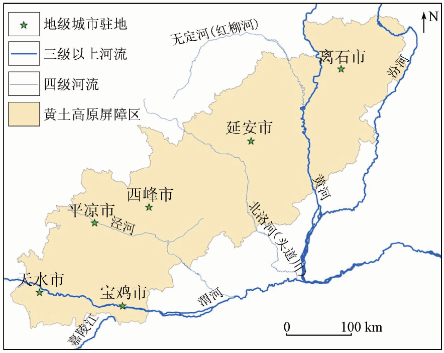
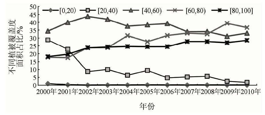
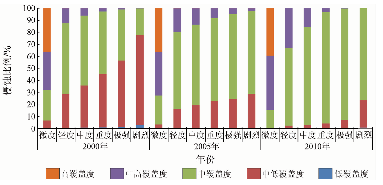
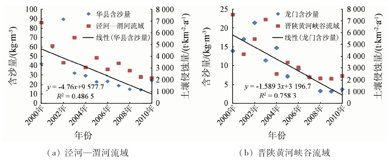
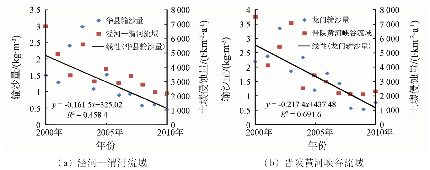
Abstract The Loess Plateau ecological barrier area is an important part of the “ two screens and three belts” in China. It not only has an important barrier effect on local residents, but also has an important impact on the middle and lower reaches of the Yellow River. This paper is based on the typical area in Loess Plateau as the research object, takes the soil conservation quantity as the evaluation index and uses the revised universal soil loss equation (RUSLE) as the evaluation method. Meanwhile, It uses the data of land use/cover change, meteorological observation, MODIS data and some other data to assess the effect function of the grain for green and the conservation of soil and water of the typical area in Loess Plateau from 2000 to 2010. The results showed that the land use/cover type changed sharply in the study area in nearly 10 years. A large number of arable land became the forest and grassland, the vegetation coverage had increased apparently and the service function of the conservation of soil and water rose linearly. The soil erosion modulus was close to 1 986.66 t·km -2·a -1 in 2010. These data show that the ecological environment has improved and the function of the conservation of soil and water have enhanced significantly since the government implemented the grain for green.
|
| Keywords
Loess Plateau
soil conservation
ecosystem services
|
|
|
|
Issue Date: 23 May 2019
|
|
|
| [1] |
张科利, 刘宝元, 蔡永明 . 土壤侵蚀预报研究中的标准小区问题论证[J]. 地理研究, 2000,19(3):297-302.
|
| [1] |
Zhang K L, Liu B Y, Cai Y M . The standard of unit plot in soil loss prediction of China[J]. Geographical Research, 2000,19(3):297-302.
|
| [2] |
傅伯杰, 徐延达, 吕一河 . 景观格局与水土流失的尺度特征与耦合方法[J]. 地球科学进展, 2010,25(7):673-681.
|
| [2] |
Fu B J, Xu Y D, Lyu Y H . Scale characteristics and coupled research of landscape pattern and soil and water loss[J]. Advances in Earth Science, 2010,25(7):673-681.
|
| [3] |
谢宝妮, 秦占飞, 王洋 , 等. 黄土高原植被净初级生产力时空变化及其影响因素[J]. 农业工程学报, 2014,30(11):244-253.
|
| [3] |
Xie B N, Qin Z F, Wang Y , et al. Spatial and temporal variation in terrestrial net primary productivity on Chinese Loess Plateau and its influential factors[J]. Transactions of the Chinese Society of Agricultural Engineering, 2014,30(11):244-253.
|
| [4] |
Pimentel D, Kounang N . Ecology of soil erosion in ecosystems[J]. Ecosystems, 1998,1(5):416-426.
doi: 10.1007/s100219900035
url: http://link.springer.com/10.1007/s100219900035
|
| [5] |
姚文艺, 肖培青 . 黄土高原土壤侵蚀规律研究方向与途径[J]. 水利水电科技进展, 2012,32(2):73-78.
|
| [5] |
Yao W Y, Xiao P Q . Research direction of the study of soil erosion in the Loess Plateau[J]. Advances in Science and Technology of Water Resources, 2012,32(2):73-78.
|
| [6] |
Zhu T X.Gully and tunnel erosion in the hilly Loess Plateau region, China[J].Geomorphology, 2012,153-154:144-155.
doi: 10.1016/j.geomorph.2012.02.019
url: https://linkinghub.elsevier.com/retrieve/pii/S0169555X12001018
|
| [7] |
Bullock A, King B . Evaluating China’s slope land conversion program as sustainable management in Tianquan and Wuqi Counties[J]. Journal of Environmental Management, 2011,92(8):1916-1922.
|
| [8] |
Wang F, Mu X M, Li R , et al. Co-evolution of soil and water conservation policy and human-environment linkages in the Yellow River Basin since 1949[J]. Science of the Total Environment, 2015,508:166-177.
doi: 10.1016/j.scitotenv.2014.11.055
url: https://linkinghub.elsevier.com/retrieve/pii/S0048969714016374
|
| [9] |
黄河上中游管理局. 黄河流域水土保持概论[M]. 郑州: 黄河水利出版社, 2011: 64-96.
|
| [9] |
Administration of the Upper and Middle Reaches of the Yellow River. Introduction to Soil and Water Conservation in the Yellow River Basin[M]. Zhengzhou: Yellow River Water Conservancy Press, 2011: 64-96.
|
| [10] |
Feng X M, Wang Y F, Chen L D , et al. Modeling soil erosion and its response to land-use change in hilly catchments of the Chinese Loess Plateau[J]. Geomorphology, 2010,118(3-4):239-248.
doi: 10.1016/j.geomorph.2010.01.004
url: https://linkinghub.elsevier.com/retrieve/pii/S0169555X10000188
|
| [11] |
高海东, 李占斌, 李鹏 , 等. 基于土壤侵蚀控制度的黄土高原水土流失治理潜力研究[J]. 地理学报, 2015,70(9):1503-1515.
|
| [11] |
Gao H D, Li Z B, Li P , et al. The capacity of soil loss control in the Loess Plateau based on soil erosion control degree[J]. Acta Geographica Sinica, 2015,70(9):1503-1515.
|
| [12] |
Milly P C D, Dunne K A, Vecchia A V . Global pattern of trends in streamflow and water availability in a changing climate[J]. Nature, 2005,438(7066):347-350.
doi: 10.1038/nature04312
|
| [13] |
穆兴民, 巴桑赤烈 Zhang Lu , 等. 黄河河口镇至龙门区间来水来沙变化及其对水利水保措施的响应[J].泥沙研究, 2007 (2):36-41.
|
| [13] |
Mu X M, Chille B, Zhang L , et al. Impact of soil conservation measures on runoff and sediment in Hekou-Longmen region of the Yellow River[J].Journal of Sediment Research, 2007 (2):36-41.
|
| [14] |
姚文艺, 冉大川, 陈江南 . 黄河流域近期水沙变化及其趋势预测[J]. 水科学进展, 2013,24(5):607-616.
|
| [14] |
Yao W Y, Ran D C, Chen J N . Recent changes in runoff and sediment regimes and future projections in the Yellow River Basin[J]. Advances in Water Science, 2013,24(5):607-616.
|
| [15] |
李天宏, 郑丽娜 . 基于RUSLE模型的延河流域2001—2010年土壤侵蚀动态变化[J]. 自然资源学报, 2012,27(7):1164-1175.
|
| [15] |
Li T H, Zheng L N . Soil erosion changes in the Yanhe Watershed from 2001 to 2010 based on RUSLE model[J]. Journal of Natural Resources, 2012,27(7):1164-1175.
|
| [16] |
Wischmeier W H, Smith D D . Predicting rainfall erosion losses from cropland east of the Rocky Mountains:A guide for selection of practices for soil and water conservation[M] //United States Department of Agriculture Handbook.Washington D C:United States Department of Agriculture, 1965.
|
| [17] |
Renard K G, Ferreira V A . RUSLE model description and database sensity[J]. Journal of Environment Quality, 1993,22(3):458-466.
|
| [18] |
Prasannakumar V, Vijith H, Abinod S , et al. Estimation of soil erosion risk within a small mountainous sub-watershed in Kerala,India,using revised universal soil loss equation (RUSLE) and geo-information technology[J]. Geoscience Frontiers, 2012,3(2):209-215.
doi: 10.1016/j.gsf.2011.11.003
url: https://linkinghub.elsevier.com/retrieve/pii/S1674987111001034
|
| [19] |
Asis A M D, Omasa K . Estimation of vegetation parameter for modeling soil erosion using linear spectral mixture analysis of Landsat ETM data[J]. ISPRS Journal of Photogrammetry and Remote Sensing, 2007,62(4):309-324.
doi: 10.1016/j.isprsjprs.2007.05.013
url: https://linkinghub.elsevier.com/retrieve/pii/S0924271607000573
|
| [20] |
卜兆宏, 孙金庄, 周伏建 , 等. 水土流失定量遥感方法及其应用的研究[J]. 土壤学报, 1997,34(3):235-245.
|
| [20] |
Bu Z H, Sun J Z, Zhou F J , et al. A study on quantitative remote sensing method of soil erosion and its application[J]. Acta Pedo-logica Sinica, 1997,34(3):235-245.
|
| [21] |
Liu B Y, Zhang K L, Xie Y. An empirical soil loss equation[C]//Proceedings 12th International Soil Conservation Organization Conference. Beijing: Tsinghua University Press, 2002: 490-494.
|
| [22] |
江忠善, 王志强, 刘志 . 黄土丘陵区小流域土壤侵蚀空间变化定量研究[J].土壤侵蚀与水土保持学报, 1996 (1):1-9.
|
| [22] |
Jiang Z S, Wang Z Q, Liu Z . Quantitative study on spatial variation of soil erosion in a small watershed in loess hilly region[J].Journal of Soil Erosion and Soil and Water Conservation, 1996 (1):1-9.
|
| [23] |
Laflen J M, Lane L J, Foster G R . WEPP:A new generation of erosion prediction technology[J]. Journal of Soil and Water Conservation, 1991,46(1):34-38.
|
| [24] |
Bathurst J C, Wicks J M , O’Connell P E .The SHE/SHESED basin scale water flow and sediment transport modelling system[J]. Computer Models of Watershed Hydrology, 1995: 563-594.
|
| [25] |
Meusburger K, Konz N, Schaub M , et al. Soil erosion modelled with USLE and PESERA using QuickBird derived vegetation parameters in an alpine catchment[J]. International Journal of Applied Earth Observation and Geoinformation, 2010,12(3):208-215.
doi: 10.1016/j.jag.2010.02.004
url: https://linkinghub.elsevier.com/retrieve/pii/S0303243410000140
|
| [26] |
盛莉, 金艳, 黄敬峰 . 中国水土保持生态服务功能价值估算及其空间分布[J]. 自然资源学报, 2010,25(7):1105-1113.
doi: 10.11849/zrzyxb.2010.07.006
|
| [26] |
Sheng L, Jin Y, Huang J F . Value estimation of conserving water and soil of ecosystem in China[J]. Journal of Natural Resources, 2010,25(7):1105-1113.
|
| [27] |
Feng X M, Wang Y F, Chen L D , et al. Modeling soil erosion and its response to land-use change in hilly catchments of the Chinese Loess Plateau[J]. Geomorphology, 2010,118(3-4):239-248.
doi: 10.1016/j.geomorph.2010.01.004
url: https://linkinghub.elsevier.com/retrieve/pii/S0169555X10000188
|
| [28] |
Renard K G, Foster G R, Weesies G A , et al. Predicting soil erosion by water:A guide to conservation planning with the revised universal soil loss equation(RUSLE)[M] //United States Department of Agriculture Handbook.Washington D C:United States Department of Agriculture, 1997.
|
| [29] |
Williams J R, Dyke P T, Jones C A . EPIC:A model for assessing the effects of erosion on soil productivity[J]. Developments in Environmental Modelling, 1983,5:553-572.
doi: 10.1016/B978-0-444-42179-1.50065-1
url: https://linkinghub.elsevier.com/retrieve/pii/B9780444421791500651
|
| [30] |
蔡崇法, 丁树文, 史志华 , 等. 应用USLE模型与地理信息系统IDRISI预测小流域土壤侵蚀量的研究[J]. 水土保持学报, 2000,14(2):19-24.
|
| [30] |
Cai C F, Ding S W, Shi Z H , et al. Study of applying USLE and geo-graphical information system IDRISI to predict soil erosion in small watershed[J]. Journal of Soil and Water Conservation, 2000,14(2):19-24.
|
| [31] |
Remortel R D V, Maichle R W, Hickey R J . Computing the LS factor for the revised universal soil loss equation through array-based slope processing of digital elevation data using a C++ executable[J]. Computers and Geosciences, 2004,30(9-10):1043-1053.
doi: 10.1016/j.cageo.2004.08.001
url: https://linkinghub.elsevier.com/retrieve/pii/S0098300404001396
|
| [32] |
冯强, 赵文武 . USLE/RUSLE中植被覆盖与管理因子研究进展[J]. 生态学报, 2014,34(16):4461-4472.
|
| [32] |
Feng Q, Zhao W W . The study on cover-management factor in USLE and RUSLE:A review[J]. Acta Ecologica Sinica, 2014,34(16):4461-4472.
|
| [33] |
Fu B J, Liu Y, Lyu Y H , et al. Assessing the soil erosion control service of ecosystems change in the Loess Plateau of China[J]. Eco-logical Complexity, 2011,8(4):284-293.
doi: 10.1016/j.ecocom.2011.07.003
url: https://linkinghub.elsevier.com/retrieve/pii/S1476945X11000602
|
| [34] |
李小文, 曹春香, 常超一 . 地理学第一定律与时空邻近度的提出[J]. 自然杂志, 2007,29(2):69-71.
doi:
|
| [34] |
Li X W, Cao C X, Chang C Y . The first law of geography and spatial-temporal proximity[J]. Chinese Journal of Nature, 2007,29(2):69-71.
|
| [35] |
Yang Q K, David J, Li R , et al. Re-scaling lower resolution slope by histogram matching[M] //Advances in Digital Terrain Analysis.Springer Berlin Heidelberg, 2008: 193-210.
|
|
Viewed |
|
|
|
Full text
|
|
|
|
|
Abstract
|
|
|
|
|
Cited |
|
|
|
|
| |
Shared |
|
|
|
|
| |
Discussed |
|
|
|
|
 2019,
Vol. 31
2019,
Vol. 31