|
|
 |
|
|
|
|
Comparison and analysis of cloud service platform and high performance platform for environmental remote sensing |
Yuanli SHI1,2, Zhongping SUN1,2( ), Jun JIANG1,2, Qian GAO1,2, Hao SUN1,2, Ruihong WEN1,2 ), Jun JIANG1,2, Qian GAO1,2, Hao SUN1,2, Ruihong WEN1,2 |
1.Satellite Environment Center, Ministry of Ecology and Environment, Beijing 100094, China
2.State Key Laboratory of Environmental Protection Satellite Remote Sensing, Beijing 100101, China |
|
|
|
|
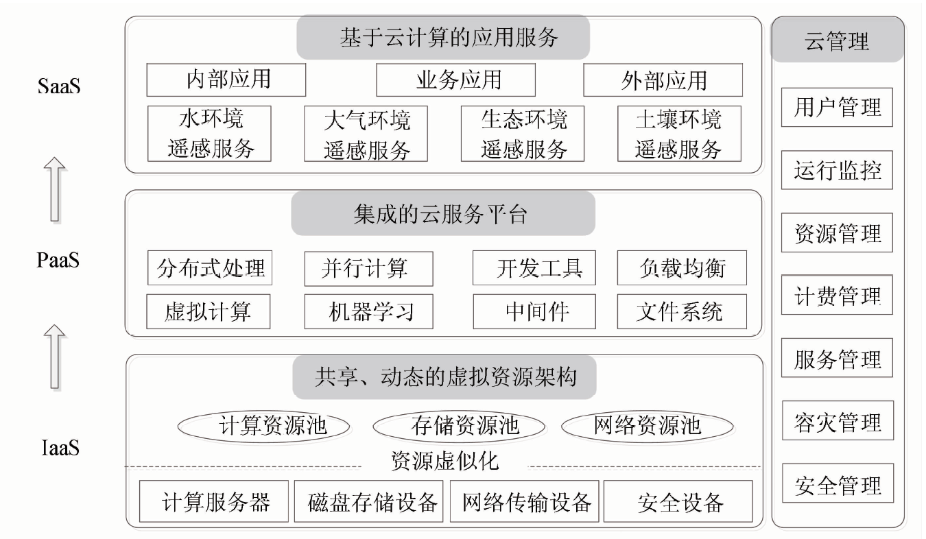
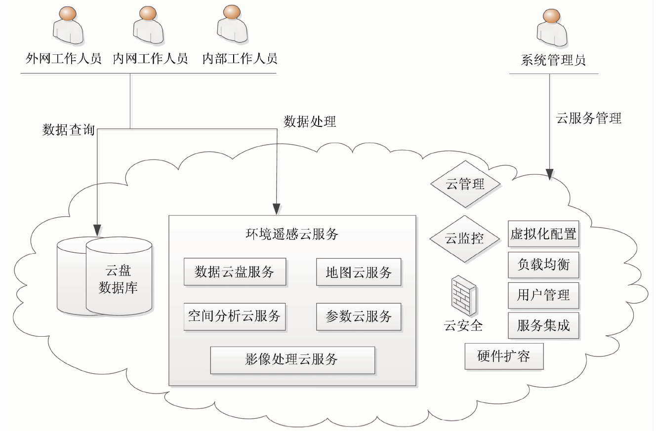
Abstract Cloud computing technology is developing rapidly and constantly expanding the application range. For exploring the cloud computing technology in the field of environmental remote sensing application, this paper discusses some key techniques of cloud computing based on virtualization and big data technology, which include architecture design, network topology and service function. 138 images of GF-1 satellite were selected for production experiments for comparing and analyzing the efficiency of cloud service platform and high performance platform in mass remote sensing data processing. Experiments show that the data processing efficiency of high performance cluster platform is about 2.5 times higher than that of cloud service platform under the existing operating environment. In general,compared with cloud service platform, dedicated high performance computing and processing platform has certain advantages in computing, communication and storage. It is more suitable for massive environmental remote sensing data processing and quantitative retrieval with efficiency.
|
| Keywords
cloud service platform
environmental remote sensing
data processing
high performance platform
|
|
|
|
Corresponding Authors:
Zhongping SUN
E-mail: sunnybnu114@163.com
|
|
Issue Date: 23 May 2019
|
|
|
| [1] |
李中元, 吴炳方 Gommes R , 等. 农情遥感监测云服务平台建设框架[J]. 遥感学报, 2015,19(4):578-585.
|
| [1] |
Li Z Y, Wu B F, Gommes R , et al. Design framework for cropwatch cloud[J]. Journal of Remote Sensing, 2015,19(4):578-585.
|
| [2] |
林林 . 水利云平台若干技术问题研究[D]. 北京:中国水利水电科学研究院, 2016.
|
| [2] |
Lin L . Research on Technology of Water Conservancy Cloud Platform[D]. Beijing:China Institute of Water Resources and Hydropower Research, 2016.
|
| [3] |
房海群 . 教育云计算服务架构研究与应用实现[D]. 成都:电子科技大学, 2015.
|
| [3] |
Fang H Q . Education Cloud Computing Services Architecture Research and Application Implementation[D]. Chengdu:University of Electronic Science and Technology of China, 2015.
|
| [4] |
丁凡 . 云环境中高性能计算应用的关键问题研究[D]. 兰州:兰州大学, 2014.
|
| [4] |
Ding F . Research on Key Issues of HPC Application in Cloud[D]. Lanzhou:Lanzhou University, 2014.
|
| [5] |
李德仁, 张良培, 夏桂松 . 遥感大数据自动分析与数据挖掘[J]. 测绘学报, 2014,43(12):1211-1216.
doi: 10.13485/j.cnki.11-2089.2014.0187
|
| [5] |
Li D R, Zhang L P, Xia G S . Automatic analysis and mining of remote sensing big data[J]. Acta Geodaetica et Cartographica Sinica, 2014,43(12):1211-1216.
|
| [6] |
王晋年 . 地球遥感信息变化应用云平台的现状与展望[J]. 科技促进发展, 2016,12(5):644-646.
|
| [6] |
Wang J N . The cloud platform of earth remote sensing information changes and application:Status and future development[J]. Science and Technology for Development, 2016,12(5):644-646.
|
| [7] |
邓书斌, 田德山, 陈秋锦 . 企业级与云遥感服务平台技术初探[C]//第十八届中国环境遥感应用技术论坛论文集, 2014: 381-385.
|
| [7] |
Deng S B, Tian D S, Chen Q J . Enterprise and cloud services platform remote sensing technology[C]//The 18th Progressing of Environmental Remote Sensing Application Technology of China, 2014: 381-385.
|
| [8] |
任伏虎, 王晋年 . 遥感云服务平台技术研究与实验[J]. 遥感学报, 2012,16(6):1331-1346.
doi: 10.11834/jrs.20121180
|
| [8] |
Ren F H, Wang J N . Turning remote sensing to cloud services:Technical research and experiment[J]. Journal of Remote Sensing, 2012,16(6):1331-1346.
|
| [9] |
武云龙, 王思勇, 李新楼 . 基于云计算的遥感数据处理模型的设计与实现[J]. 电脑知识与技术, 2010,6(14):3646-3648.
|
| [9] |
Wu Y L, Wang S Y, Li X L . Spatial data processing model design and implement based on cloud computing[J]. Computer Knowledge and Technology, 2010,6(14):3646-3648.
|
| [10] |
刘异, 呙维, 江万寿 , 等. 一种基于云计算模型的遥感处理服务模式研究与实现[J]. 计算机应用研究, 2009,26(9):3428-3431.
|
| [10] |
Liu Y, Guo W, Jiang W S , et al. Research of remote sensing service based on cloud computing mode[J]. Application Research of Computers, 2009,26(9):3428-3431.
|
| [11] |
熊礼治 . 云环境下遥感影像内容安全研究[D]. 武汉:武汉大学, 2016.
|
| [11] |
Xiong L Z . Study on Content Security of Remote Sensing Image in Cloud Computing[D]. Wuhan:Wuhan University, 2016.
|
| [12] |
史园莉, 申文明, 熊文成 , 等. 遥感数据集群处理作业调度管理系统研究[J]. 计算机工程与应用, 2012,48(25):77-82.
|
| [12] |
Shi Y L, Shen W M, Xiong W C , et al. Research on job schedule and management system for remote sensing data processing with cluster[J]. Computer Engineering and Applications, 2012,48(25):77-82.
|
| [13] |
Wong A K L, Goscinski A M . A unified framework for the deployment,exposure and access of HPC applications as services in clouds[J]. Future Generation Computer Systems, 2013,29(6):1333-1344.
doi: 10.1016/j.future.2013.01.014
url: https://linkinghub.elsevier.com/retrieve/pii/S0167739X13000307
|
| [14] |
Hill Z, Humphrey M. A quantitative analysis of high performance computing with Amazon’s EC2 infrastructure:The death of the local cluster? [C]//Proceedings of the 10th IEEE/ACM International Conference on Grid Computing, 2009: 26-33.
|
| [15] |
吕相文, 袁家斌, 张玉洁 . 云计算环境下多GPU资源调度机制研究[J]. 小型微型计算机系统, 2016,37(4):687-693.
|
| [15] |
Lyu X W, Yuan J B, Zhang Y J . Study on resource scheduling mechanism of multi-GPU in cloud computing environment[J] Journal of Chinese Computer Systems, 2016,37(4):687-693.
|
| [16] |
刘明亮 . 高性能云计算平台存储系统配置关键技术研究[D]. 北京:清华大学, 2014.
|
| [16] |
Liu M L . Research on Key Technologies of Cloud Storage System Configurations for High Performance Applilcations[D]. Beijing:Tsinghua University, 2014.
|
|
Viewed |
|
|
|
Full text
|
|
|
|
|
Abstract
|
|
|
|
|
Cited |
|
|
|
|
| |
Shared |
|
|
|
|
| |
Discussed |
|
|
|
|
 2019,
Vol. 31
2019,
Vol. 31