|
|
 |
|

|
|
|
A study of the parametric method of sky view factor on complex underlying surface in urban area: A case study of national sport stadium area in Beijing |
Xin DUAN1,2, Deyong HU1,2( ), Shisong CAO1,2, Chen YU1,2, Yani ZHANG1,2 ), Shisong CAO1,2, Chen YU1,2, Yani ZHANG1,2 |
1. College of Resources Environment and Tourism, Capital Normal University, Beijing 100048, China
2. Beijing Key Laboratory of Resources, Environment and Geographic Information System, Beijing 100048, China |
|
|
|
|
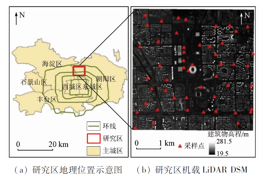
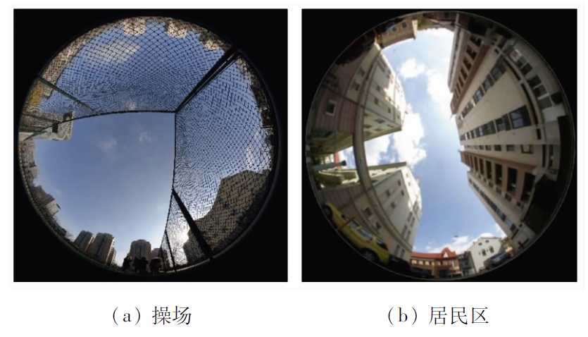
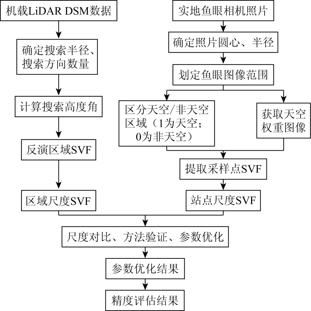
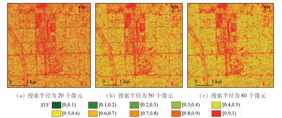
Abstract Sky view factor (SVF) is a numerical value that describes the three-dimensional characteristics of the city, and hence it is widely used in urban heat island effect, urban energy balance and some other fields. In this study, taking the national sport stadium area as the study area, the authors calculated the SVFs based on the digital surface model (DSM) in the urban areas. Furthermore, fisheye photos were used to extract the in-situ SVFs. Finally, the authors compared and analyzed the results between these two methods. The main conclusions are as follows: ①The SVF value calculated based on the DSM is affected by the search radius and the search direction number. SVFs are decreasing with the increasing of the search radius and the search direction number; ②Specifically, when the search direction is 32 and the search radius is 80 pixels, the value of RMSE is 0.064 (noting that it is the lowest value). The SVF values calculated using the DSM are most similar to those calculated using fisheye photos; ③A certain correlation is observed between the SVF values calculated using the fisheye photos and those calculated based on the DSM, indicating the feasibility of using DSM to calculate the SVF in large urban areas.
|
| Keywords
SVF
digital surface model
fisheye photos
urban areas
|
|
|
|
Corresponding Authors:
Deyong HU
E-mail: deyonghu@cnu.edu.cn
|
|
Issue Date: 30 August 2019
|
|
|
| [1] |
Zeng L Y, Lu J, Li W Y , et al. A fast approach for large-scale sky view factor estimation using street view images[J]. Building and Environment, 2018,135:74-84.
|
| [2] |
袁超 . 缓解高密度城市热岛效应规划方法的探讨——以香港城市为例[J].建筑学报, 2010(s1):120-123.
|
| [2] |
Yuan C . Mitigating urban heat island effects of high density cities:A study at Hong Kong[J].Architectural Journal, 2010(s1):120-123.
|
| [3] |
Brown M J, Grimmond S, Ratti C . Comparison of methodologies for computing sky view factor in urban environments [C]//International Society of Enviromental Hydraulics Conference. 2001: 6-9.
|
| [4] |
Taleghani M, Kleerekoper L, Tenpierik M , et al. Outdoor thermal comfort within five different urban forms in the Netherlands[J]. Building and Environment, 2015,83:65-78.
|
| [5] |
Yang J, Wong M S, Menenti M , et al. Modeling the effective emissivity of the urban canopy using sky view factor[J]. Journal of Photogrammetry and Remote Sensing, 2015,105:211-219.
|
| [6] |
Yang J, Wong M S, Menenti M , et al. Development of an improved urban emissivity model based on sky view factor for retrieving effective emissivity and surface temperature over urban areas[J]. Journal of Photogrammetry and Remote Sensing, 2016,122:30-40.
|
| [7] |
Yang X, Li Y . The impact of building density and building height heterogeneity on average urban albedo and street surface temperature[J]. Building and Environment, 2015: 145-156.
|
| [8] |
Yang J, Wong M S, Menenti M , et al. Study of the geometry effect on land surface temperature retrieval in urban environment[J]. Journal of Photogrammetry and Remote Sensing, 2015,109:77-87.
|
| [9] |
Oke T R . Canyon geometry and the nocturnal urban heat island:Comparison of scale model and field observations[J]. International Journal of Climate, 1981,1(3):237-254.
|
| [10] |
Unger J . Intra-urban relationship between surface geometry and urban heat island:Review and new approach[J]. Climate Research, 2004,27(3):253-264.
|
| [11] |
Radhi H, Fikry F, Sharples S . Impacts of urbanisation on the thermal behaviour of new built up environments:A scoping study of the urban heat island in Bahrain[J]. Landscape and Urban Planning, 2013,113:47-61.
|
| [12] |
Wang Y P, Akbari H . Effect of sky view factor on outdoor temperature and comfort in Montreal[J]. Environmental Engineering Science, 2014,31:272-287.
|
| [13] |
Scarano M, Sobrino J A . On the relationship between the sky view factor and the land surface temperature derived by Landsat-8 images in Bari,Italy[J]. International Journal of Remote Sensing, 2015,36(19-20):4820-4835.
|
| [14] |
Steyn D G . The calculation of view factors from fisheye-lens photographs:Research note[J]. Atmosphere-Ocean, 1980,18(3):254-258.
|
| [15] |
Holmer B . A simple operative method for determination of sky view factors in complex urban canyons from fisheye photographs[J]. Meteorologische Zeitschrift,N.F., 1992,1:236-239.
|
| [16] |
Holmer B, Postgard U, Eriksson M . Sky view factors in forest canopies calculated with IDRISI[J]. Theoretical and Applied Climatolo-gy, 2011,68:33-40.
|
| [17] |
Bruse M, Fleer H . Simulating surface-plant-air interactions inside urban environments with a three dimensional numerical model[J]. Environmental Modelling and Software, 1998,13(3-4):373-384.
|
| [18] |
Grimmond C S B, Potter S K, Zutter H N , et al. Rapid methods to estimate sky view factors applied to urban areas[J]. International Journal of Climatology, 2001,21:903-913.
|
| [19] |
Chapman L, Thornes J E, Bradley A V . Short communication sky view factor approximation using GPS receivers[J]. International Journal of Climatology, 2002,22:615-621.
|
| [20] |
Hodul M, Knudby A, Ho H C . Estimation of continuous urban sky view factor from Landsat data using shadow detection[J]. Remote Sensing, 2016,8(7):568-582.
|
| [21] |
Ratti C, Richens P . Urban texture analysis with image processing techniques[J]. Computers in Building, 1999, 49-64.
|
| [22] |
Ga T, Lindberg F, Unger J . Computing continuous sky view factors using 3D urban raster and vector databases:Comparison and application to urban climate[J]. Theoretical and Applied Climatology, 2009,95:111-123.
|
| [23] |
Kastendeuch P P . Short communication a method to estimate sky view factors from digital elevation models[J]. International Journal of Climatology, 2013,33:1574-1578.
|
| [24] |
Souza L, Rodrigues D S, Mendes J F G .Sky view factors estimation using a 3D-GIS extension [C]//8th International IBPSA Conference. 2003: 1227-1234.
|
| [25] |
Matzarakis A, Matuschek O . Sky view factor as a parameter in applied climatology-rapid estimation by the SkyHelios model[J]. Meteorologische Zeitschrif, 2011,20(7):39-45.
|
| [26] |
Zakšek K, Oštir K, Kokalj Z . Sky view factor as a relief visualization technique[J]. Remote Sensing, 2011,3:398-415.
|
|
Viewed |
|
|
|
Full text
|
|
|
|
|
Abstract
|
|
|
|
|
Cited |
|
|
|
|
| |
Shared |
|
|
|
|
| |
Discussed |
|
|
|
|
 2019,
Vol. 31
2019,
Vol. 31