|
|
 |
|

|
|
|
Multi-scale segmentation of satellite imagery by edge-incorporated weighted aggregation |
Dechao ZHAI1,2, Yanan FAN3, Yanan ZHOU2( ) ) |
1. Institute of Geographic Sciences and Natural Resources Research, University of Chinese Academy of Sciences,Beijing 100020, China
2. Department of Geographical Information Science, Hohai University,Nanjing 211100, China
3. Tianjin Institute of Surveying and Mapping, Tianjin 300381, China |
|
|
|
|
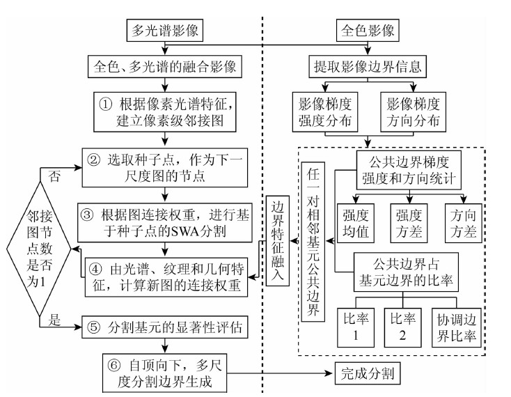
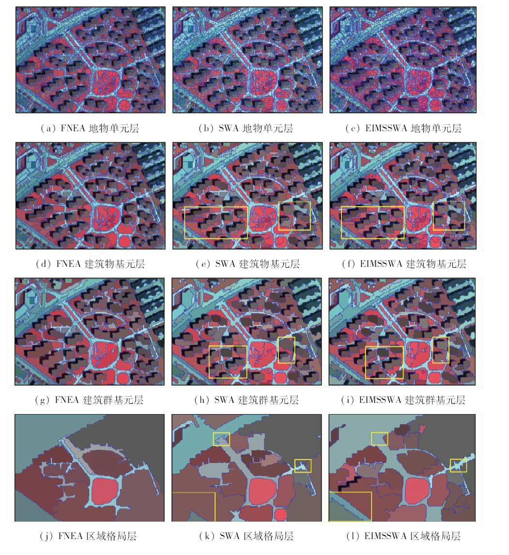
Abstract Some existing remote sensing image segmentation methods do not take the edge feature into consideration, therefore, an edge-incorporated multi-scale segmentation algorithm based on weighted aggregation (EIMSSWA) is proposed. Firstly, the edge features of adjacent primitives are generated by counting the gradient strength and gradient direction on the common edges. Secondly, these features are infused into the similarity measurement of the adjacent primitives in segmentation by weighted aggregation, so as to improve the segmentation. Finally, the segmentation of the proposed method is compared with segmentations of eCognition as well as segmentation by weighted aggregation (SWA) a. The results demonstrate that the EIMSSWA method is capable of gaining more accurate and more reasonable segmentation.
|
| Keywords
edge feature
multi-scale
image segmentation
weighted aggregation
|
|
|
|
Corresponding Authors:
Yanan ZHOU
E-mail: zhouyn@hhu.edu.cn
|
|
Issue Date: 30 August 2019
|
|
|
| [1] |
Hotter M, Thoma R . Image segmentation based on object oriented mapping parameter estimation[J]. Signal Processing, 1988,15(3):315-334.
|
| [2] |
明冬萍 . 高分辨率遥感特征基元提取与格局判别方法研究[D]. 北京:中国科学院研究生院, 2006.
|
| [2] |
Ming D P . Study of Parcel Unit Extraction Based-on Features and Pattern Distinguishment from High Spatial Resolution Remote Sensing Images[D]. Beijing:Graduate University of Chinese Academy of Sciences, 2006.
|
| [3] |
骆剑承, 周成虎, 沈占锋 , 等. 遥感信息图谱计算的理论方法研究[J]. 地球信息科学学报, 2009,11(5):664-669.
|
| [3] |
Luo J C, Zhou C H, Shen Z F , et al. Theoretic and methodological review on sensor information tupu computation[J]. Journal of Geo-Information Science, 2009,11(5):664-669.
|
| [4] |
陈忠 . 高分辨率遥感图像分类技术研究[D]. 北京:中国科学院研究生院, 2006.
|
| [4] |
Chen Z . Research on High Resolution Remote Sensing Image Classification Technology[D]. Beijing:Graduate University of Chinese Academy of Sciences, 2006.
|
| [5] |
Baatz M, Schape A . Multiresolution segmentation:An optimization approach for high quality multi-scale image segmentation[J]. Journal of Photogrammetry and Remote Sensing, 2000,58(3-4):12-23.
|
| [6] |
Huang X, Zhang L P . A comparative study of spatial approaches for urban mapping using hyperspectral ROSIS images over Pavia City,northern Italy[J]. International Journal of Remote Sensing, 2009,30(12):3205-3221.
|
| [7] |
Comaniciu D, Meer P . Mean shift:A robust approach toward feature space analysis[J]. IEEE Transactions on Pattern Analysis and Machine Intelligence, 2002,24(5):603-619.
|
| [8] |
明冬萍, 周文, 汪闽 . 基于谱空间统计特征的高分辨率影像分割尺度估计[J]. 地球信息科学学报, 2016,18(5):622-631.
doi: 10.3724/SP.J.1047.2016.00622
|
| [8] |
Ming D P, Zhou W, Wang M . Scale parameter estimation based on the spatial and spectral statistics in high spatial resolution image segmentation[J]. Journal of Geo-Information Science, 2016,18(5):622-631.
|
| [9] |
Sharon E, Brandt A, Basri R . Fast multiscale image segmentation [C]//Proceedings IEEE Conference on Computer Vision and Pattern Recognition.IEEE, 2000: 70-77.
|
| [10] |
Liu Y F, Zou L, Li J , et al. Segmentation by weighted aggregation and perceptual hash for pedestrian detection[J]. Journal of Visual Communication and Image Representation, 2016,36:80-89.
|
| [11] |
Boykov Y, Jolly M P . Interactive graph cuts for optimal boundary and region segmentation of objects in N-D images [C]//International Conference on Computer Vision,IEEE Computer Society.IEEE, 2001: 105-112.
|
| [12] |
Wang X Y, Sun W W, Wu Z F , et al. Color image segmentation using PDTDFB domain hidden Markov tree model[J]. Applied Soft Computing Journal, 2015,29:138-152.
|
| [13] |
Choi H, Baraniuk R G . Multiscale image segmentation using wavelet-domain hidden Markov models[J]. IEEE Transactions on Image Processing, 2001,10(9):1309-1321.
|
| [14] |
Duda R O, Hart P E . Use of the hough transformation to detect lines and curves in pictures[J]. Communications of the ACM, 1972,15(1):11-15.
|
| [15] |
Sharon E, Galum M, Sharon D , et al. Hierarchy and adaptivity in segmenting visual scenes[J]. Nature, 2006,442(7104):810-813.
|
| [16] |
贾建华, 焦李成 . 空间一致性约束谱聚类算法用于图像分割[J]. 红外与毫米波学报, 2010,29(1):69-74.
url: http://www.opticsjournal.net/Articles/Abstract?aid=OJ100721000015tZw3y6
|
| [16] |
Jia J H, Jiao L C . Image segmentation by spectral clustering algorithm with spatial coherence constraints[J]. Journal of Infrared and Millimeter Waves, 2010,29(1):69-74.
|
| [17] |
Shi J B, Malik J . Normalized cuts and image segmentation[J]. IEEE Transactions on Pattern Analysis and Machine Intelligence, 2000,22(8):888-905.
|
| [18] |
王爱萍, 王树根, 吴会证 . 利用分层聚合进行高分辨率遥感影像多尺度分割[J]. 武汉大学学报(信息科学版), 2009,34(9):1055-1058.
|
| [18] |
Wang A P, Wang S G, Wu H Z . Multiscale segmentation of high resolution satellite imagery by hierarchical aggregation[J]. Geomatics and Information Science of Wuhan University, 2009,34(9):1055-1058.
|
| [19] |
章毓晋 . 图像工程[M]. 2版.北京: 清华大学出版社, 2007.
|
| [19] |
Zhang Y J. Image Engineering[M].2nd ed. Beijing: Tsinghua University Press, 2007.
|
| [20] |
Battz M, Bentz U , Dehghanni US et al.eCognition Professional User Guide 8[M]. Munchen:Definiens AG, 2009.
|
| [21] |
明冬萍, 骆剑承, 周成虎 , 等. 高分辨率遥感影像特征分割及算法评价分析[J]. 地球信息科学, 2006,8(1):103-109.
|
| [21] |
Ming D P, Luo J C, Zhou C H , et al. Research on high resolution remote sensing image segmentation methods based on features and evaluation of algorithms[J]. Geo-Information Science, 2006,8(1):103-109.
|
| [22] |
张仙, 明冬萍 . 面向地学应用的遥感影像分割评价[J]. 测绘学报, 2015,44(s1):108-116.
|
| [22] |
Zhang X, Ming D P . Geo-application oriented evaluations of remote sensing image segmentation[J]. Acta Geodaetica et Cartographica Sinica, 2015,44(s1):108-116.
|
|
Viewed |
|
|
|
Full text
|
|
|
|
|
Abstract
|
|
|
|
|
Cited |
|
|
|
|
| |
Shared |
|
|
|
|
| |
Discussed |
|
|
|
|
 2019,
Vol. 31
2019,
Vol. 31