|
|
 |
|

|
|
|
A study of high temperature targets identification method based on spectral index |
Qin ZHENG, Jun PAN( ), Lijun JIANG, Lixin XING, Yue JI, Yifan YU, Pengju WANG, Weijing ZHONG ), Lijun JIANG, Lixin XING, Yue JI, Yifan YU, Pengju WANG, Weijing ZHONG |
| College of Geoexploration Science and Technology, Jilin University, Changchun 130026, China |
|
|
|
|
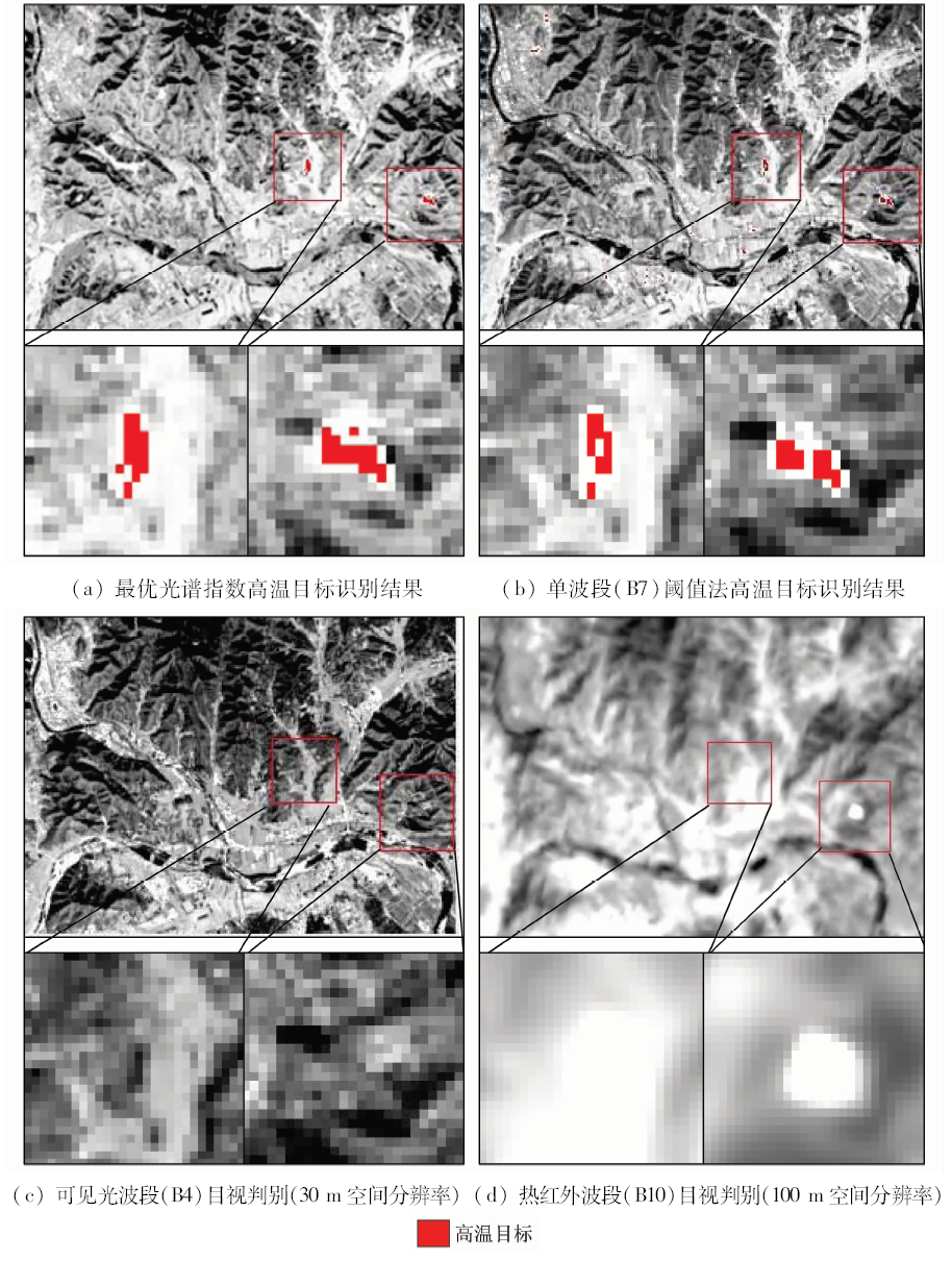
Abstract At present, most of the bands or spectral indices used in the high temperature target remote sensing recognition researches only involve qualitative analysis, with the lack of quantitative evaluation indicators and screening methods. In order to establish a universal band screening principle and screening method for judging indicators so as to achieve effective identification of high temperature targets, the authors, according to the idea of variance analysis, constructed a separability metric to screen characteristic bands between high temperature targets and various types of normal temperature objects respectively, determined some effective bands for high temperature targets identification, constructed identification indices with the spectral characteristics of the ground objects, and screened the optimal one. The result shows that the optimal spectral index determined by quantitative screening can effectively distinguish high temperature targets from most normal temperature objects. On such a basis, by using the other optimal identification index between high temperature targets and their confusing color steel objects to identify once again, the recognition accuracy could be improved further, and recognition accuracy of high temperature targets reached 95.4% and 97.6% , respectively.
|
| Keywords
high temperature target
variance analysis
separability metric
characteristic band
spectral index
|
|
|
|
Corresponding Authors:
Jun PAN
E-mail: panj@jlu.edu.cn
|
|
Issue Date: 30 August 2019
|
|
|
| [1] |
袁悦 . 高温目标短波红外遥感识别方法改进研究[D]. 长春:吉林大学, 2015.
|
| [1] |
Yuan Y . The Study of High-Temperature Targets Identification Method Improvement in Shortwave Infrared Remote Sensing[D]. Changchun:Jilin University, 2015.
|
| [2] |
袁悦, 潘军, 邢立新 , 等. 基于Fisher两类判别的高温目标精确识别方法[J]. 科学技术与工程, 2015,15(9):109-113.
|
| [2] |
Yuan Y, Pan J, Xing L X , et al. Identification of high temperature targets based on Fisher two types discrimination[J]. Science Technology and Engineering, 2015,15(9):109-113.
|
| [3] |
朱雅静 . 高温地物目标短波红外遥感识别及温度反演[D]. 长春:吉林大学, 2012.
|
| [3] |
Zhu Y J . High-Temperature Target Identification and Temperature Retrieval Using Shortwave Infrared Remote Sensing Data[D]. Changchun:Jilin University, 2012.
|
| [4] |
于一凡, 潘军, 邢立新 , 等. 基于马氏距离的遥感图像高温目标识别方法研究[J]. 遥感信息, 2013,28(5):90-94.
|
| [4] |
Yu Y F, Pan J, Xing L X , et al. Identification of high temperature targets in remote sensing imagery based on Mahalanobis distance[J]. Remote Sensing Information, 2013,28(5):90-94.
|
| [5] |
于一凡, 潘军, 邢立新 , 等. 短波红外波段高温目标识别的可行性分析[J]. 国土资源遥感, 2014,26(1):25-30.doi: 10.6046/gtzyyg.2014.01.05.
doi: 10.6046/gtzyyg.2014.01.05
|
| [5] |
Yu Y F, Pan J, Xing L X , et al. Feasibility analysis of shortwave infrared band for recognition of high temperature target[J]. Remote Sensing for Land and Resources, 2014,26(1):25-30.doi: 10.6046/gtzyyg.2014.01.05.
|
| [6] |
于一凡 . 短波红外遥感高温目标温度反演模型研究[D]. 长春:吉林大学, 2014.
|
| [6] |
Yu Y F . The Study of High-Temperature Targets Temperature Retrieval Model in Shortwave Infrared Remote Sensing[D]. Changchun:Jilin University, 2014.
|
| [7] |
Yu Y F, Xing L X, Pan J , et al. Study of high temperature targets identification and temperature retrieval experimental model in SWIR remote sensing based Landsat-8[J]. International Journal of Applied Earth Observation and Geoinformation, 2016,46:56-62.
|
| [8] |
田应福, 张钊, 朱晓坡 . 方差分析的两个重要问题及其解决方法[J].统计与决策, 2013(16):7-9.
|
| [8] |
Tian Y F, Zhang Z, Zhu X P . Two important problems of variance analysis and their solutions[J].Statistics and Decision Making, 2013(16):7-9.
|
| [9] |
纪宏金, 时艳香, 陆继龙 . 地球化学数据统计分析[M]. 长春: 吉林大学出版社, 2014: 138-145.
|
| [9] |
Ji H J, Shi Y X, Lu J L. Statistical Analysis of Geochemical Data[M]. Changchun: Jilin University Publishing Press, 2014: 138-145.
|
| [10] |
季悦, 潘军, 蒋立军 , 等. 基于方差分析的Landsat8数据高温目标识别方法研究[J]. 世界地质, 2017,36(4):1297-1302.
|
| [10] |
Ji Y, Pan J, Jiang L J , et al. Methods of identifying high temperature target from Landsat8 data using variance analysis[J]. Global Geology, 2017,36(4):1297-1302.
|
| [11] |
郭建坤 . 基于时序NDVI的土地覆被变化检测方法研究[D]. 北京:中国科学院研究生院, 2005.
|
| [11] |
Guo J K . Study on Land Cover Change Detection Method Based on Time Series NDVI[D]. Beijing:Graduate University of Chinese Academy of Science, 2005.
|
| [12] |
王鹏举, 潘军, 蒋立军 , 等. 林火目标遥感多光谱识别指数构建方法研究[J]. 科学技术与工程, 2018,18(2):312-319.
|
| [12] |
Wang P J, Pan J, Jiang L J , et al. Method of remote sensing multispectral recognition index construction for forest fire[J]. Science Technology and Engineering, 2018,18(2):312-319.
|
| [13] |
纪宏金 . 地球化学背景与异常划分的多元方法[J]. 长春地质学院学报, 1988,18(3):311-320.
|
| [13] |
Ji H J . Multivariate method for distinguishing geochemical background from geochemical anomalies[J]. Journal of Changchun University of Earth Science, 1988,18(3):311-320.
|
| [14] |
纪宏金 . 多元正态总体假设检验在矿化带识别中的应用[J]. 长春地质学院学报, 1991,21(3):321-326.
|
| [14] |
Ji H J . Application of multivariate normal population hypojournal test in identification of mineralized zone[J]. Journal of Changchun University of Earth Science, 1991,21(3):321-326.
|
| [15] |
何阳, 杨进, 马勇 , 等. 基于Landsat-8陆地卫星数据的火点检测方法[J]. 红外与毫米波学报, 2016,35(5):600-608.
url: http://www.opticsjournal.net/Articles/Abstract?aid=OJ161024000075gMiPlR
|
| [15] |
He Y, Yang J, Ma Y , et al. A method for fire detection using Landsat-8 data[J]. Journal of Infrared and Millimeter Waves, 2016,35(5):600-608.
|
|
Viewed |
|
|
|
Full text
|
|
|
|
|
Abstract
|
|
|
|
|
Cited |
|
|
|
|
| |
Shared |
|
|
|
|
| |
Discussed |
|
|
|
|
 2019,
Vol. 31
2019,
Vol. 31