|
|
 |
|

|
|
|
Feature extraction and classification of hyperspectral image with ground-sky synchronization test |
| Xiaolu LIAO, Jia LIU, Xingxia ZHOU |
| Surveying and Mapping Technology Service Center, Sichuan Surveying and Mapping Geographic Information Bureau, Chengdu 610081, China |
|
|
|
|
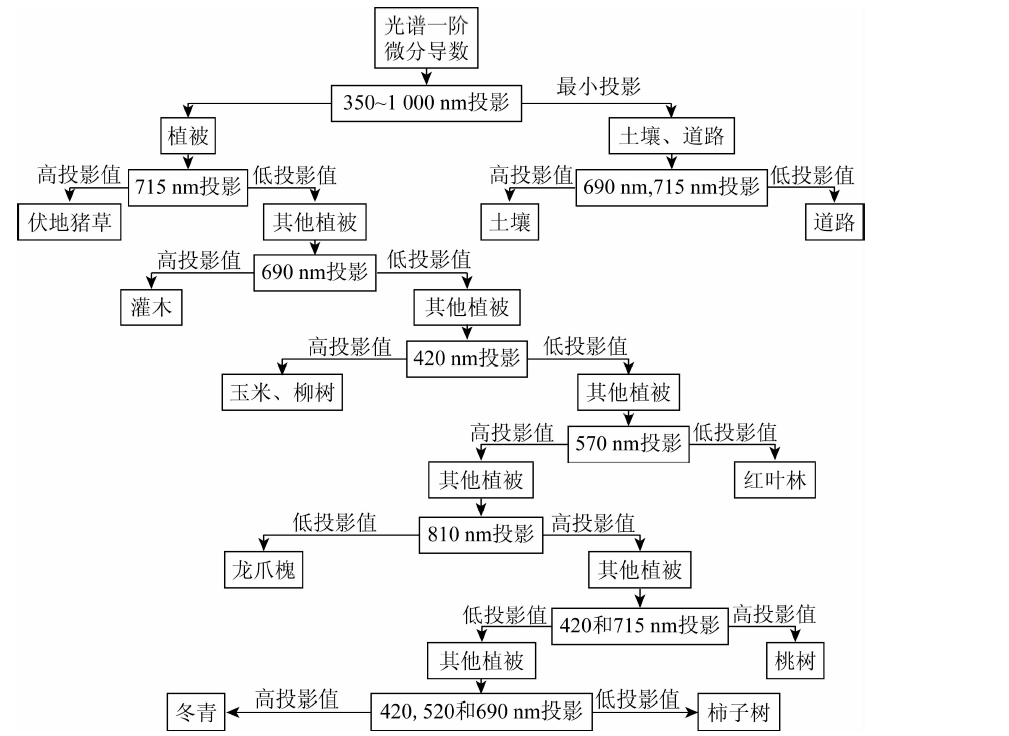
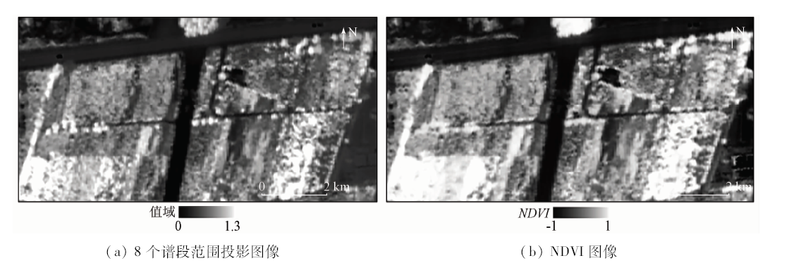
Abstract In view of the lack of theoretical research on the extraction and inversion of hyperspectral features in ground-sky synchronization, the authors, in combination with the principle of “maximum density within class and maximum distance between classes”, studied the separability and importance selection of the spectra for different ground objects in different spectral regions, proposed an improved projection pursuit classification method, and realized the projection pursuit method based on weighted feature band. In the case study, the spectral and PHI hyperspectral images of different ground objects in the experimental area were collected synchronously and, combined with the measured spectra on the ground, constructed different classification rules around the strategy of overall optimization and local optimization. It was applied to the classification of PHI hyperspectral image to extract the information of vegetation and non-vegetation and to subdivide more than ten different kinds of ground objects. The results show that 8 spectral areas are important separability bands of different vegetation: 420 nm, 520 nm, 570 nm , 610 nm, 660 nm, 690 nm, 715 nm, and 810 nm. The classification results have the advantages of strong stratification, clear outline of vegetation and avoiding shadow influence.
|
| Keywords
hyperspectral image
characteristic analysis
ground-sky synchronization test
projection pursuit
|
|
|
|
Issue Date: 30 August 2019
|
|
|
| [1] |
王建宇, 舒嵘, 刘银年 , 等. 成像光谱技术导论[M]. 北京: 科学出版社, 2011.
|
| [1] |
Wang J Y, Shu R, Liu N Y , et al. Introduction to Imaging Spectroscopy[M]. Beijing: Science Press, 2011.
|
| [2] |
童庆禧, 张兵, 张立福 . 中国高光谱遥感的前沿进展[J]. 遥感学报, 2016,20(5):689-707.
|
| [2] |
Tong Q X, Zhang B, Zhang L F . Current progress of hyperspectral remote sensing in China[J]. Journal of Remote Sensing, 2016,20(5):689-707.
|
| [3] |
童庆禧 .我国高光谱遥感的发展[N].中国测绘报, 2008 -04-18(003).
|
| [3] |
Tong Q X . The development of hyperspectral remote sensing in China[N]. China Surveying and Mapping, 2008 -0418(003).
|
| [4] |
Gu Y F, Wang C, You D , et al. Representative multiple kernel learning for classification in hyperspectral imagery[J]. IEEE Transaction on Geoscience and Remote Sensing, 2012,50(7):2852-2865.
|
| [5] |
Moser G, Serpico S B . Combining support vector machines and Markov random fields in an intergrated framework for contextual image classification[J]. IEEE Transactions on Geoscience and Remote Sensing, 2013,51(5):2734-2752.
|
| [6] |
陈伟 . 高光谱影像地物智能化提取理论与方法研究[D]. 郑州:解放军信息工程大学, 2012.
|
| [6] |
Chen W . Research on the Theory and Method for Intelligent Extraction of Objects in Hyperspectral Images[D]. Zhengzhou:PLA Information Engineering University, 2012.
|
| [7] |
Jia X P, Kuo B C, Crawford M M . Feature mining for hyperspectral image classification[J]. Proceedings of the IEEE, 2013,101(3):676-679.
|
| [8] |
魏峰 . 高光谱遥感数据特征提取与特征选择方法研究[D]. 西安:西北工业大学, 2015.
|
| [8] |
Wei F . Research on Feature Extraction and Feature Selection for Hyperspectral Remote Sensing Data[D]. Xi’an:Northwest University of Technology, 2015.
|
| [9] |
孙艳丽 . 联合丰度信息与空谱特征的高光谱影像分类研究[D].北京:中国科学院大学( 中国科学院遥感与数字地球研究所), 2017.
|
| [9] |
Sun Y L . Hyperspectral Image Classification with Abundance Information and Spatial Spectrum Characteristics[D].Beijing:University of Chinese Academy of Sciences(Institute of Remote Sensing and Digital Earth,Chinese Academy of Sciences), 2017.
|
| [10] |
王春阳 . 基于信息熵的自训练半监督高光谱遥感影像分类研究[D]. 焦作:河南理工大学, 2015.
|
| [10] |
Wang C Y . Research on Self-Training Semi-Supervised Classification for Hyperspectral Remote Sensing Image Based on Information Entropy[D]. Jiaozuo:Henan University of Science and Technology, 2015.
|
| [11] |
康旭东 . 高光谱遥感影像空谱特征提取与分类方法研究[D]. 长沙:湖南大学, 2015.
|
| [11] |
Kang X D . Research on Spectral-Spatial Feature Extraction and Classification Methods for Hyperspectral Remote Sensing Imagery[D]. Changsha:Hunan University, 2015.
|
| [12] |
Xue Z H, Du P J, Li J , et al. Simultaneous sparse graph embedding for hyperspectral image classification[J]. IEEE Transaction on Geoscience and Remote Sensing, 2015,53(11):6114-6133.
|
| [13] |
Benediktsson J A, Chanussot J, Fauvel M . Multiple classifier systems in remote sensing:From basics to recent developments [C]//7th International Workshop on Multiple Classifier System, 2007: 501-512.
|
| [14] |
樊雪, 刘清旺, 谭炳香 . 基于机载PHI高光谱数据的森林优势树种分类研究[J]. 国土资源遥感, 2017,29(2):110-116.doi: 10.6046/gtzyyg.2017.02.16.
|
| [14] |
Fan X, Liu Q W, Tan B X . Classification of forest species using airborne PHI hyperspectral data[J]. Remote Sensing for Land and Resources, 2017,29(2):110-116.doi: 10.6046/gtzyyg.2017.02.16.
|
| [15] |
杜培军, 夏俊士, 薛朝辉 , 等. 高光谱遥感影像分类研究进展[J]. 遥感学报, 2016,20(2):236-256.
|
| [15] |
Du P J, Xia J S, Xue Z H , et al. Review of hyperspectral remote sensing image classification[J]. Journal of Remote Sensing, 2016,20(2):236-256.
|
| [16] |
张兵 . 高光谱图像处理与信息提取前沿[J]. 遥感学报, 2016,20(5):1062-1090.
|
| [16] |
Zhang B . Advancement of hyperspectral image processing and information extraction[J]. Journal of Remote Sensing, 2016,20(5):1062-1090.
|
| [17] |
杨金红 . 高光谱遥感数据最佳波段选择方法研究[D]. 南京:南京信息工程大学, 2005.
|
| [17] |
Yang J H . Study on the Optimum Band Selection Method for Hyperspectral Remote Sensing Data[D]. Nanjing:Nanjing University of Information Engineering, 2005.
|
| [18] |
刘璐 . 基于类内类间距离的模糊聚类算法及图像分割应用[D]. 西安:西安邮电大学, 2016.
|
| [18] |
Liu L . Fuzzy Clustering Algorithm Based on Intra-Class Distance and Its Application in Image Segmentation[D]. Xi’an:Xi’an University of Posts and Telecommunications, 2016.
|
| [19] |
郭亚琴, 王正群 . 基于类内类间离散度的分类器设计方法[J]. 信息技术, 2010,34(5):35-37.
|
| [19] |
Guo Y Q, Wang Z Q . Classifier design based on between-class and within-class scatter[J]. Information Technology, 2010,34(5):35-37.
|
| [20] |
刘璐, 吴成茂 . 基于类内类间距离的模糊C-均值聚类分割算法[J]. 计算机工程与设计, 2016,37(6):1626-1631.
|
| [20] |
Liu L, Wu C M . Fuzzy C-means clustering segmentation algorithm based on intra-class and inter-class distance[J]. Computer Engineering and Design, 2016,37(6):1626-1631.
|
| [21] |
Shivhare P, Gupta V . Review of image segmentation techniques:Including pre and post processing operations[J]. International Journal of Engineering and Advanced Technology, 2015,4(3):153-157.
|
| [22] |
向东进 . 实用多元统计分析[M]. 武汉: 中国地质大学出版社, 2005.
|
| [22] |
Xiang D J. Practical Multivariate Statistical Analysis[M]. Wuhan: China University of Geosciences Press, 2005.
|
| [23] |
韩明 . 应用多元统计分析[M]. 上海: 同济大学出版社, 2017.
|
| [23] |
Han M. Application of Multivariate Statistical Analysis[M]. Shanghai: Tongji University Press, 2017.
|
| [24] |
杜欣, 黄晓霞, 李红旮 , 等. 基于投影寻踪学习网络算法的植物群落高分遥感分类研究[J]. 地球信息科学学报, 2016,18(1):124-132.
doi: 10.3724/SP.J.1047.2016.00124
url: http://d.wanfangdata.com.cn/Periodical/dqxxkx201601015
|
| [24] |
Du X, Huang X X, Li H G , et al. Research on classification of plant community using projection pursuit learning network algorithm on high resolution remote sensing images[J]. Journal of Geo-Information Science, 2016,18(1):124-132.
|
| [25] |
郭亚军 . 综合评价理论、方法及应用[M]. 北京: 科学出版社, 2008.
|
| [25] |
Guo Y J . Comprehensive Evaluation Theory, Method and Application[M]. Beijing: Science Press, 2008.
|
| [26] |
林文鹏, 李厚增, 黄敬峰 , 等. 上海城市植被光谱反射特征分析[J]. 光谱学与光谱分析, 2010,30(11):3111-3114.
url: http://www.opticsjournal.net/Articles/Abstract?aid=OJ110126000705bIeKhN
|
| [26] |
Lin W P, Li H Z, Huang J F , et al. Analysis on urban vegetations reflectance characteristics in Shanghai[J]. Spectroscopy and Spectral Analysis, 2010,30(11):3111-3114.
|
| [27] |
杨可明, 陈云浩, 郭达志 , 等. 基于PHI高光谱影像的植被光谱特征应用研究[J]. 西安科技大学学报, 2006,26(4):494-498.
|
| [27] |
Yang K M, Chen Y H, Guo D Z , et al. Application of vegetation spectral features based on PHI imaging data[J]. Journal of Xi’an University of Science and Technology, 2006,26(4):494-498.
|
| [28] |
孙岩 . 湿地植物高光谱特征分析与物种识别模型构建[D]. 北京:清华大学, 2008.
|
| [28] |
Sun Y . Hyperspectral Characters Species Identification Model for Wetland Plants[D]. Beijing:Tsinghua University, 2008.
|
|
Viewed |
|
|
|
Full text
|
|
|
|
|
Abstract
|
|
|
|
|
Cited |
|
|
|
|
| |
Shared |
|
|
|
|
| |
Discussed |
|
|
|
|
 2019,
Vol. 31
2019,
Vol. 31