|
|
|
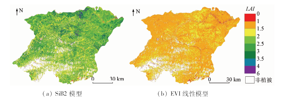
Abstract In this study, domestic GF-1 WFV data were used as the data source, SiB2 model was used to estimate the LAI of forest vegetation in Mohe County of Heilongjiang Province and the value was compared with the estimation result of the enhanced vegetation index (EVI) linear model. Estimation results of the two models were combined with the synchronous ground LAI data for accuracy evaluation. The results show that the coefficient of determination (R 2) of the LAI estimated by the EVI linear model is 0.582, and its root mean square error (RMSE) is 0.701. The R 2 of the LAI estimated by the SiB2 model is 0.798, and its RMSE is 0.358. Compared with the performance of the EVI linear model, the results estimated by the SiB2 model are improved on both R 2 and RMSE. The results show that the SiB2 model is more suitable for LAI inversion of forest vegetation in the study area, in combination with the high spatial resolution GF-1 WFV data.
|
| Keywords
GF-1 WFV data
SiB2 model
LAI
EVI linear model
|
|
|
|
Corresponding Authors:
Xianlin QIN
E-mail: noaags@ifrit.ac.cn
|
|
Issue Date: 30 August 2019
|
|
|
| [1] |
Chen J M . Canopy architecture and remote sensing of the fraction of photosynthetically active radiation absorbed by boreal conifer forests[J]. IEEE Transactions on Geoscience and Remote Sensing, 1996,34(6):1353-1368.
|
| [2] |
柳艺博, 居为民, 陈镜明 , 等. 2000—2010年中国森林叶面积指数时空变化特征[J]. 科学通报, 2012,57(16):1435-1445.
|
| [2] |
Liu Y B, Ju W M, Chen J M , et al. Spatial and temporal variations of forest LAI in China during 2000—2010[J]. Chinese Science Bulletin, 2012,57(16):1435-1445.
|
| [3] |
Fang H, Liang S, Kuusk A . Retrieving leaf area index using a genetic algorithm with a canopy radiative transfer model[J]. Remote Sensing of Environment, 2003,85(3):257-270.
|
| [4] |
蔡博峰, 绍霞 . 基于PROSPECT+SAIL模型的遥感叶面积指数估算[J]. 国土资源遥感, 2007,19(2):39-43.doi: 10.6046/gtzyyg.2007.02.10.
doi: 10.6046/gtzyyg.2007.02.10
|
| [4] |
Cai B F, Shao X . Leaf area index petrieval based on remotely sensed data and PROSPECT+SAIL model[J]. Remote Sensing for Land and Resources, 2007,19(2):39-43.doi: 10.6046/gtzyyg.2007.02.10.
|
| [5] |
刘英, 吴立新, 马保东 . 基于TM/ETM+光谱特征空间的土壤湿度遥感监测[J]. 中国矿业大学学报, 2013,42(2):296-301.
|
| [5] |
Liu Y, Wu L X, Ma B D . Remote sensing monitoring of soil moisture on the basis of TM/ETM+ spectral space[J]. Journal of China University of Mining and Technology, 2013,42(2):296-301.
|
| [6] |
梁顺林, 李小文, 王锦地 , 等 .定量遥感: 理念与算法[M]. 北京: 科学出版社, 2013.
|
| [6] |
Liang S L, Li X W, Wang J D , et al. Quantitative Remote Sensing Concept and Algorithm[M]. Beijing: Science Press, 2013.
|
| [7] |
邢丽玮, 李小娟, 李昂晟 , 等. 基于高光谱与多光谱植被指数的洪河沼泽植被叶面积指数估算模型对比研究[J]. 湿地科学, 2013,11(3):313-319.
|
| [7] |
Xing L W, Li X J, Li A S , et al. A comparative study on estimation model for leaf area index of vegetation in marshes in Honghe national nature reserve based on hyperspectral and multispectral vegetation indices[J]. Wetland Science, 2013,11(3):313-319.
|
| [8] |
Turner D P, Cohen W B, Kennedy R E , et al. Relationships between leaf area index and Landsat TM spectral vegetation indices across three temperate zone sites[J]. Remote Sensing of Environment, 1999,70(1):52-68.
|
| [9] |
Sellers P J, Randall D A, Collatz G J , et al. A revised land surface parameterization (SiB2) for atmospheric GCMs.Part I:Model formulation[J]. Journal of Climate, 1996,9(4):676-705.
|
| [10] |
Sellers P J, Los S O, Tucker C J , et al. A revised land surface parameterization (SiB2) for atmospheric GCMs,PartII:The generation of global fields of terrestrial biophysical parameters from satellite data[J]. Journal of Climate, 1996,9(4):706-737.
|
| [11] |
高志球, 卞林根, 程彦杰 , 等. 利用生物圈模型(SiB2)模拟青藏高原那曲草原近地面层能量收支[J]. 应用气象学报, 2002,13(2):129-141.
|
| [11] |
Gao Z Q, Bian L G, Cheng Y J , et al. Modeling of energy budget using simple biosphere model version 2 (SiB2) over Tibetan Naqu prairie[J]. Journal of Applied Meteorological Science, 2002,13(2):129-141.
|
| [12] |
何志强, 沈新勇, 王英舜 , 等. 利用简单生物圈模式SiB2模拟锡林浩特草原地表湍流通量[J]. 气候与环境研究, 2011,16(3):353-368.
|
| [12] |
He Z Q, Shen X Y, Wang Y S , et al. Modeling of the surface turbulence fluxes over a typical steppe prairie in Inner Mongolia,China by using the simple biosphere model 2(SiB2)[J]. Climatic and Environmental Research, 2011,16(3):353-368.
|
| [13] |
Boegh E, Soegaard H, Broge N , et al. Airborne multispectral data for quantifying leaf area index,nitrogen concentration,and photosynthetic efficiency in agriculture[J]. Remote Sensing of Environment, 2002,81(2):179-193.
|
| [14] |
周以良 . 中国大兴安岭植被[M]. 北京: 科学出版社, 1991: 4-6.
|
| [14] |
Zhou Y L. Vegetation of Da Hinggan Ling in China[M]. Beijing: Science Press, 1991: 4-6.
|
| [15] |
柳生吉 . 大兴安岭呼中林区林火蔓延三维模拟[J].安徽农业科学, 2015(14):306-310,331.
|
| [15] |
Liu S J . Simulation of forest fire growth in an integrated 3D virtual geographical environment in Daxinganling Huzhong area[J].Journal of Anhui Agricultural Sciences, 2015(14):306-310,331.
|
| [16] |
陆春玲, 王瑞, 尹欢 . “高分一号”卫星遥感成像特性[J].航天返回与遥感, 2014(4):67-73.
|
| [16] |
Lu C L, Wang R, Yin H . GF-1 satellite remote sensing characters[J].Spacecraft Recovery and Remote Sensing, 2014(4):67-73.
|
| [17] |
孙桂芬, 覃先林, 尹凌宇 , 等. 基于时序高分一号宽幅影像火后植被光谱及指数变化分析[J]. 光谱学与光谱分析, 2018,38(2):511-517.
url: http://www.opticsjournal.net/Articles/Abstract?aid=OJ1803140001433z6B9E
|
| [17] |
Sun G F, Qin X L, Yin L Y , et al. Changes analysis of post-fire vegetation spectrum and index based on time series GF-1 WFV images[J]. Spectroscopy and Spectral Analysis, 2018,38(2):511-517.
|
| [18] |
张敏, 袁辉 . 拉依达(PauTa)准则与异常值剔除[J]. 郑州工业大学学报, 1997,18(1):84-88.
|
| [18] |
Zhang M, Yuan H . The PauTa criterion and rejecting the abnormal value[J]. Journal of Zhengzhou University of Technology, 1997,18(1):84-88.
|
| [19] |
Zhou M C, Ishidaira H, Hapuarachchi H P , et al. Estimating potential evapotranspiration using Shuttleworth-Wallace model and NOAA-AVHRR NDVI data to feed a distributed hydrological model over the Mekong River basin[J]. Journal of Hydrology, 2006,327(1-2):151-173.
|
| [20] |
Sellers P J . Canopy reflectance,photosynjournal,and transpiration[J]. International Journal of Remote Sensing, 1985,6(8):1335-1372.
|
| [21] |
Monteith J L, Unsworth M H . Principles of Environmental Physics[M]. London:Edward Arnold, 1990: 290-292.
|
| [22] |
Harrison E F, Minnis P, Barkstrom B R , et al. Seasonal variation of cloud radiative forcing derived from the earth radiation budget experiment[J]. Journal of Geophysical Research, 1990,95(d11):18687-18703.
|
| [23] |
Sellers P J, Berry J A, Collatz G J , et al. Canopy reflectance,photosynjournal and transpiration.Part III:A re-analysis using improved leaf models and a new canopy integration scheme[J]. Remote Sensing of Environment, 1992,42(3):187-216.
|
|
Viewed |
|
|
|
Full text
|
|
|
|
|
Abstract
|
|
|
|
|
Cited |
|
|
|
|
| |
Shared |
|
|
|
|
| |
Discussed |
|
|
|
|
 2019,
Vol. 31
2019,
Vol. 31
 ), Shuchao LIU, Guifen SUN, Qian LIU