|
|
 |
|

|
|
|
Research on the application of LBV transformation in domestic ZY-3 satellite images |
| Baoquan WEI1,2, Anning SUO2, Ying LI1, Jianhua ZHAO2 |
1. College of Navigation, Dalian Maritime University, Dalian 116026, China
2. National Marine Environmental Monitoring Center, Dalian 116023, China |
|
|
|
|
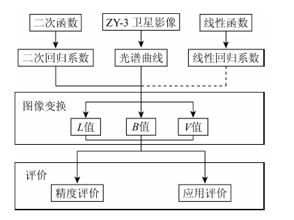
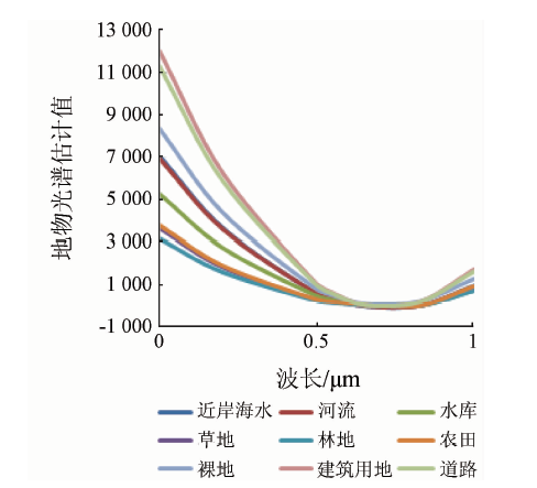
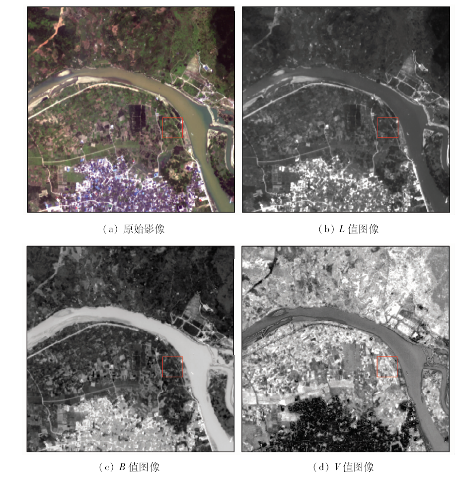
Abstract According to the spectral features of domestic ZY-3 remote sensing images, the formula of LBV transformation for ZY-3 is proposed and deduced, and the feasibility of improving the quality of ZY-3 remote sensing images is testified. At first, based on the characteristics of ZY-3 remote sensing images, the spectral information of nine types of typical ground features were selected, and regression coefficients were used to calculate regression coefficients. Then, the three components of L, B, V of ZY-3 satellite images were calculated according to the characteristics of the typical ground features space (bare land, water body, vegetation), color space (red, green, blue) and the space of LBV variables (the general radiance level of the ground objects, the visiable - infrared radiation balance, the band radiance variation vector). Finally, the experiments of ZY-3 remote sensing image in Ningde City of Fujian Province were carried out, and quantitative analysis was conducted to evaluate the experimental results. Firstly, the results show that, in the aspect of the visual effects, compared with the original image, the transformed image is more clear, and the details are more abundant, and thus can contribute more to the determination and identification of subsequent features. Secondly, through the LBV transformation, the image information entropy is 6.21, the average gradient is 4.71, the deviation coefficient is 0.46, and the quality of the remote sensing image is better than other transformation methods. Thirdly, by classifying the LBV image, the overall accuracy is up to 89.71%, and the Kappa coefficient is the highest, reaching 0.875 3. The classification accuracy is higher than that of other transformation methods. Therefore, The LBV transformation can improve the quality of ZY-3 remote sensing image, and it can be applied to ZY-3 remote sensing image processing and information extraction.
|
| Keywords
LBV transformation
image transformation
high spatial resolution
ZY-3 satellite
accuracy analysis
|
|
|
|
Issue Date: 30 August 2019
|
|
|
| [1] |
薛东剑, 何政伟, 仇文侠 , 等. 基于EML与SML实现遥感影像融合质量评价及应用研究[J].遥感信息, 2009(6):63-67.
|
| [1] |
Xue D J, He Z W, Qiu W X , et al. Quality assessment and application of remote sensing image fusion based on EML and SML[J].Remote Sensing Information, 2009(6):63-67.
|
| [2] |
吴连喜, 王茂新 . 一种光谱保持型的图像融合方法[J]. 遥感学报, 2004,8(4):356-361.
doi: 10.11834/jrs.20040410
|
| [2] |
Wu L X, Wang M X . A new method of RS image fusion preserving spectrum[J]. Journal of Remote Sensing, 2004,8(4):356-361.
|
| [3] |
陆冬华, 赵英俊 . 基于改进型Brovery算法的高光谱数据融合技术[J]. 世界核地质科学, 2006,23(3):177-180.
|
| [3] |
Lu D H, Zhao Y J . Fusing Hyperion and Pan data by an improved Brovery algorithm[J]. World Nuclear Geoscience, 2006,23(3):177-180.
|
| [4] |
张生, 赵春三, 杨桄 , 等. 多光谱与高分辨率图像融合方法比较研究[J].遥感信息, 2007(5):56-60.
|
| [4] |
Zhang S, Zhao C S, Yang G , et al. Study on fusion algorithm for multi-spectral image and high resolution image[J].Remote Sensing Information, 2007(5):56-60.
|
| [5] |
Yesou H, Besnus Y, Rolet Y . Extraction of spectral information from Landsat TM data and merger with SPOT panchromatic imagery:A contribution to the study of geological structures[J]. ISPRS Journal of Photogrammetry and Remote Sensing, 1993,48(5):23-36.
|
| [6] |
Zhang Y . Problems in the fusion of commercial high-resolution satellite as well as Landsat 7 ETM+ images and initial solutions [C]//International Archives of Photogrammetry and Remote Sensing(IAPRS) “Geospatial Theory,Processing and Applications”, 2002.
|
| [7] |
Chien C L, Tsai W H . Image fusion with no gamut problem by improved nonlinear IHS transforms for remote sensing[J]. IEEE Transactions on Geoscience and Remote Sensing, 2014,52(1):651-663.
|
| [8] |
Schetselaar E M . On preserving spectral balance in image fusion and its advantages for geological image interpretation[J]. Photogrammetric Engineering and Remote Sensing, 2001,67(8):925-934.
|
| [9] |
Zhang Y . Highlight article:Understanding image fusion[J]. Photogrammetric Engineering and Remote Sensing, 2004,70(6):657-661.
|
| [10] |
Kempeneers P, Sedano F, Seebach L , et al. Data fusion of different spatial resolution remote sensing images applied to forest-type mapping[J]. IEEE Transactions on Geoscience and Remote Sensing, 2011,49(12):4977-4986.
|
| [11] |
胡洋, 习晓环, 王城 , 等. Pleiades卫星影像融合方法与质量评价[J]. 遥感技术与应用, 2014,29(3):476-481.
|
| [11] |
Hu Y, Xi X H, Wang C , et al. Study on fusion methods and quality assessment of Pleiades data[J]. Remote Sensing Technology and Application, 2014,29(3):476-481.
|
| [12] |
许开宇, 李双一 . 基于小波变换的图像融合算法的实现[J]. 红外技术, 2007,29(8):455-458.
|
| [12] |
Xu K Y, Li S Y . An images fusion algorithm based on Wavelet transform[J]. Infrared Technology, 2007,29(8):455-458.
|
| [13] |
Zhang Y, Mishra P K . A review and comparison of commercially available pan-sharpening techniques for high resolution satellite image fusion [C]//2012 IEEE International Geoscience and Remote Sensing Symposium.Munich:IEEE, 2012.
|
| [14] |
Luo B, Khan M M, Bienvenu T , et al. Decision-based fusion for pan-sharpening of remote sensing images[J]. IEEE Geoscience and Remote Sensing Letters, 2013,10(1):19-23.
|
| [15] |
姜红艳, 邢立新, 梁立恒 , 等. PanSharpening自动融合算法及应用研究[J]. 测绘与空间地理信息, 2008,31(5):73-75.
|
| [15] |
Jiang H Y, Xing L X, Liang L H , et al. Study on PanSharpening auto-fusion arithmetic and application[J]. Geomatics and Spatial Information Technology, 2008,31(5):73-75.
|
| [16] |
Ghanbari Z, Sahebi M R . Improved HIS algorithm for fusing high resolution satellite images of urban areas[J]. Journal of the Indian Society of Remote Sensing, 2014,42(4):689-699.
|
| [17] |
刘军, 邵振峰 . 快速离散Curvelet变换和HIS变换集成的遥感影像融合方法[J]. 测绘科学, 2012,37(1):121-124.
|
| [17] |
Liu J, Shao Z F . An integrated image fusion method based on HIS and fast discrete Curvelet transform[J]. Science of Surveying and Mapping, 2012,37(1):121-124.
|
| [18] |
杨桄, 童涛, 陆松岩 , 等. 基于多特征的红外与可见光图像融合[J]. 光学精密工程, 2014,22(2):489-496.
|
| [18] |
Yang G, Tong T, Lu S Y , et al. Fusion of infrared and visible images based on multi-features[J]. Optics and Precision Engineering, 2014,22(2):489-496.
|
| [19] |
张惊雷, 赵俄英 . 基于NSCT的红外与可见光图像融合方法[J]. 激光与红外, 2013,43(3):319-323.
|
| [19] |
Zhang J L, Zhao E Y . Fusion method for infrared and visible light images based on NSCT[J]. Laser and Infrared, 2013,43(3):319-323.
|
| [20] |
Zeng Z Y . A new method of data transformation for satellite images:I.Methodology and transformation equations for TM images[J]. International Journal of Remote Sensing, 2007,28(18):4095-4124.
|
| [21] |
Zeng Z Y . A new method of data transformation for satellite images:II.Transformation equations for SPOT,NOAA,IKONOS,Quick Bird,ASTER,MSS and other images and application[J]. International Journal of Remote Sensing, 2007,28(18):4125-4155.
|
| [22] |
栗敏光, 范洪冬, 邓喀中 . 基于LBV变换的TM数据水体提取新方法[J]. 测绘科学, 2010,35(3):138-139.
|
| [22] |
Li M G, Fan H D, Deng K Z . New methods for water body extraction from TM data based on LBV transformation[J]. Science of Surveying and Mapping, 2010,35(3):138-139.
|
| [23] |
王贺, 陈劲松, 余晓敏 . HJ数据的LBV变换及其在面向对象分类中的应用[J]. 遥感技术与应用, 2013,28(6):1020-1026.
|
| [23] |
Wang H, Chen J S, Yu X M . LBV transformation for HJ-1B data and application in object-oriented classification[J]. Remote Sensing Technology and Application, 2013,28(6):1020-1026.
|
| [24] |
彭笃明, 张安定, 李德一 , 等. 基于LBV变换的遥感影像多步骤分类方法研究[J]. 测绘科学, 2008,33(3):56-58.
|
| [24] |
Peng D M, Zhang A D, Li D Y , et al. Study on multi-step classification of remote sensing image based on LBV transformation[J]. Science of Surveying and Mapping, 2008,33(3):56-58.
|
| [25] |
张成雯, 唐家奎, 米素娟 , 等. 中巴02B卫星多光谱影像中LBV数据变换方法研究[J]. 地理与地理信息科学, 2011,27(3):21-25.
|
| [25] |
Zhang C W, Tang J K, Mi S J , et al. Research on new LBV data transformation method for CBERS-02B multi-spectral images[J]. Geography and Geo-Information Science, 2011,27(3):21-25.
|
| [26] |
张成雯, 唐家奎, 米素娟 , 等. 基于LBV数据变换方法的海岸带多光谱影像分类方法研究[J]. 地理与地理信息科学, 2010,26(4):53-56.
|
| [26] |
Zhang C W, Tang J K, Mi S J , et al. Research and evaluation of coastal zone multi-spectral image classification based on LBV transformation[J]. Geography and Geo-Information Science, 2010,26(4):53-56.
|
| [27] |
孟育红, 刘勇 . ALOS全色与多光谱影像融合方法比较[J]. 地理空间信息, 2012,10(5):99-102.
|
| [27] |
Meng Y H, Liu Y . Comparison of image fusion methods for ALOS panchromatic and multi-spectral images[J]. Geospatial Information, 2012,10(5):99-102.
|
|
Viewed |
|
|
|
Full text
|
|
|
|
|
Abstract
|
|
|
|
|
Cited |
|
|
|
|
| |
Shared |
|
|
|
|
| |
Discussed |
|
|
|
|
 2019,
Vol. 31
2019,
Vol. 31