|
|
 |
|

|
|
|
Extraction of buildings in remote sensing imagery based on multi-level segmentation and classification hierarchical model and feature space optimization |
| Tao DANG1,2, Qi SONG1, Yong LIU2, Anjian XU1, Bo XU1, Honggang ZHANG1 |
1. Xi’an Information Technique Institute of Surveying and Mapping, Xi’an, 710054, China;
2. College of Earth and Enviromental Sciences, Lanzhou University, Lanzhou 730000, China |
|
|
|
|
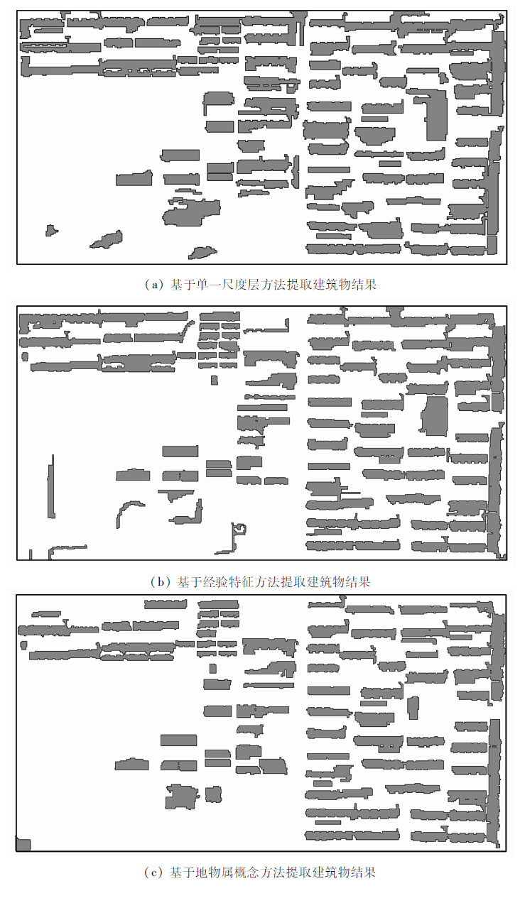
Abstract In view of the problems of scale effect, spectral diversity and classification feature optimization in the extraction of urban objects information from high spatial resolution remote sensing images,the authors, based on the object-based image analysis method and combined with data mining and machine learning,propose a multi-level segmentation and classification hierarchical model and its feature space optimization method for building extraction. First, according to the multi-scale characteristics of remote sensing information, a hierarchical relationship is set up for the difference of features of ground objects, and then a hierarchical structure based on information segmentation and classification is established based on the characteristics of spectral diversity to define the subtypes of ground objects. After that, the proposed Relief F-PSO combination feature selection method is used. Finally,on the basis of multiscale segmentation and feature optimization, the water surface distribution is obtained based on the random forest model, and finally the building information is extracted by the J48 decision tree algorithm. Experimental results show that the method can utilize a small number of image feature attributes to get high-precision building extraction results.
|
| Keywords
object-based image analysis
buildings
segmentation and classification hierarchical model
feature selection
|
|
|
|
Issue Date: 30 August 2019
|
|
|
| [1] |
王俊, 秦其明, 叶昕 , 等. 高分辨率光学遥感图像建筑物提取研究进展[J]. 遥感技术与应用, 2016,31(4):653-660.
doi: 10.11873/j.issn.1004-0323.2016.4.0653
|
| [1] |
Wang J, Qin Q M, Ye X , et al. A survey of building extraction methods from optical high resolution remote sensing imagery[J]. Remote Sensing Technology and Application, 2016,31(4):653-662.
|
| [2] |
孙庆玲, 冯险峰 . 基于GeoEye-1影像的城区建筑物提取方法研究[J]. 遥感信息, 2013,28(4):8-12.
|
| [2] |
Sun Q L, Feng X F . Extraction of urban building based on GeoEye-1 image[J]. Remote Sensing Information, 2013,28(4):8-12.
|
| [3] |
郭怡帆, 张锦, 卫东 . 面向对象的高分辨遥感影像建筑物轮廓提取研究[J]. 测绘通报, 2014,( s2):300-303.
|
| [3] |
Guo Y F, Zhang J, Wei D . The research of object-oriented building contour extraction of high-resolution remote sensing image[J].Bulletin of Surveying and Mapping, 2014(s2):300-303.
|
| [4] |
唐羊洋, 叶华平, 吴书金 , 等. 基于波段与形状特征的遥感影像建筑物分类提取[J]. 后勤工程学院学报, 2016,32(1):93-96.
|
| [4] |
Tang Y Y, Ye H P, Wu S J , et al. Building classification and extraction form remote sensing image based on wave range and shape features[J]. Journal of Logistical Engineering University, 2016,32(1):93-96.
|
| [5] |
王宏涛, 王变利 . 融合LiDAR和多光谱影像的建筑物自动检测[J]. 测绘科学, 2015,40(8):64-67.
|
| [5] |
Wang H T, Wang B L . Automatic building detection fusing LiDAR and multispectral imagery[J]. Science of Surveying and Mapping, 2015,40(8):64-67.
|
| [6] |
王旭东, 段福洲, 屈新原 , 等. 面向对象和SVM结合的无人机数据建筑物提取[J]. 国土资源遥感, 2017,29(1):97-101.doi: 10.6046/gtzyyg.2017.01.15.
|
| [6] |
Wang X D, Duan F Z, Qu X Y , et al. Building extraction based on UAV imagery data with the synergistic use of objected-based method and SVM clsssifier[J]. Remote Sensing for Land and Resources, 2017,29(1):97-101.doi: 10.6046/gtzyyg.2017.01.15.
|
| [7] |
Turker M, Koc-San D . Building extraction from high-resolution optical spaceborne images using the integration of support vector machine (SVM) classification,Hough transformation and perceptual grouping[J]. International Journal of Applied Earth Observation and Geoinformation, 2016,34:58-69.
|
| [8] |
Dornaika F, Moujahida A, Merabet Y E , et al. Building detection from orthophotos using a machine learning approach:An empirical study on image segmentation and descriptors[J]. Expert Systems With Applications, 2016,58:130-142.
|
| [9] |
Chen L, Zhao S H, Han W Q , et al. Building detection in an urban area using LiDAR data and QuickBird imagery[J]. International Journal of Remote Sensing, 2012,33:5135-5148.
|
| [10] |
Awrangjeb M, Zhang C, Fraser C S . Automatic extraction of building roofs using LiDAR data and multispectral imagery[J]. ISPRS Journal of Photogrammetry and Remote Sensing, 2013,83:1-18.
|
| [11] |
胡婷 . 遥感图像典型地物特征提取的尺度效应研究[D]. 西安:西北大学, 2010.
|
| [11] |
Hu T . The Study of Scale Effects in Typical Objects’ Feature Extraction from Remote Sensing Image[D]. Xi’an:Northwest University, 2010.
|
| [12] |
黄慧萍, 吴炳方 . 地物提取的多尺度特征遥感应用分析[J]. 遥感技术与应用, 2003,18(5):276-281.
|
| [12] |
Huang H P, Wu B F . Analysis of the mutli-scale characteristics with objects extraction[J]. Remote Sensing Technology and Application, 2003,18(5):276-281.
|
| [13] |
李秦, 高锡章, 张涛 , 等. 最优分割尺度下的多层次遥感地物分类实验分析[J]. 地球信息科学学报, 2011,13(3):409-416.
doi: 10.3724/SP.J.1047.2011.00409
|
| [13] |
Li Q, Gao X Z, Zhang T , et al. Optimal segmentation scale selection and evaluation for multi-layer image recognition and classification[J]. Journal of Geo-Information Science, 2011,13(3):409-416.
|
| [14] |
吴俐民, 左小清, 倪曙 , 等. 卫星遥感影像专题信息提取技术与应用[M]. 成都: 西南交通大学出版社, 2013.
|
| [14] |
Wu L M, Zuo X Q, Ni S , et al. Special Information Extraction Technology and Application of Satellite Remote Sensing Images[M]. Chengdu: Southwest Jiaotong University press, 2013.
|
| [15] |
吕凤华, 舒宁, 龚龑 , 等. 利用多特征进行航空影像建筑物提取[J]. 武汉大学学报信息科学版, 2017,42(5):656-660.
|
| [15] |
Lyu F H, Shu N, Gong Y , et al. Regular building extraction from high resolution image based on multilevel-features[J]. Geomatics and Information Science of Wuhan University, 2017,42(5):656-660.
|
| [16] |
吴炜, 骆剑承, 沈占锋 等. 光谱和形状特征相结合的高分辨遥感图像的建筑物提取方法[J]. 武汉大学学报信息科学版, 2012,37(7):800-804.
|
| [16] |
Wu W, Luo J C, Shen Z F , et al. Building extraction from high resolution remote sensing imagery based on spatial-spectral method[J]. Geomatics and Information Science of Wuhan University, 2012,37(7):800-805.
|
| [17] |
谭衢霖 . 高分辨率多光谱影像城区建筑物提取研究[J]. 测绘学报, 2010,39(6):618-623.
|
| [17] |
Tan Q L . Urban building extraction from VHR multi-spectral images using object-based classification[J]. Acta Geodaetica et Cartographica Sinica, 2010,39(6):618-623.
|
| [18] |
蒋胜利 . 高维数据的特征选择与特征提取研究[D]. 西安:西安电子科技大学, 2011.
|
| [18] |
Jiang S L . Research on Feature Selection and Feature Extraction for High-Dimensional Data[D]. Xi’an:Xidian University, 2011.
|
| [19] |
刘舒, 姜琦刚, 马玥 , 等. 基于多目标遗传随机森林特征选择的面向对象湿地分类[J]. 农业机械学报, 2017,48(1):119-127.
|
| [19] |
Liu S, Jiang Q G, Ma Y , et al. Object-oriented wetland classification based on hybrid feature selection method combing with Relief F,multi-objective genetic algorithm and random forest[J]. Transactions of the Chinese Society for Agricultural Machinery, 2017,48(1):119-127.
|
| [20] |
薛章鹰, 刘兴权 . 结合ReliefF、GA和SVM的面向对象建筑物目标识别特征选择方法[J]. 测绘工程, 2017,26(2):52-56.
|
| [20] |
Xue Z Y, Liu X Q . Feature selection method for object-oriented building targets recognition based on ReliefF,GA and SVM[J]. Engineering of Surveying and Mapping, 2017,26(2):52-56.
|
| [21] |
吴卿 . 基于高分辨率遥感影像的水土保持生态建设监测方法研究[D]. 北京:北京林业大学, 2007.
|
| [21] |
Wu Q . Study on Monitoring Method for Ecological Construction of Water and Soil Conservation Based On High-Resolution Remote Sensing Images[D]. Beijing:Beijing Forestry University, 2007.
|
| [22] |
李晓霞, 汪云甲 . 面向对象的高分辨率影像采煤塌陷地提取[J]. 计算机工程与应用, 2011,47(23):239-241.
doi:
|
| [22] |
Li X X, Wang Y J . Coal mine subsidence area extraction for high-resolution remote sensing imagery based on object-oriented classification method[J]. Computer Engineering and Application, 2011,47(23):239-241.
|
| [23] |
肖艳, 姜琦刚, 王斌 , 等. 基于ReliefF和PSO混合特征选择的面向对象土地利用分类[J]. 农业工程学报, 2016,32(4):211-215.
|
| [23] |
Xiao Y, Jiang Q G, Wang B , et al. Object based land-use classification based on hybrid feature selection method of combining ReliefF and PSO[J]. Transaction of the Chinese Society of Agricultural Engineering, 2016,32(4):211-215.
|
| [24] |
Liu Y, Bian L, Meng Y , et al. Discrepancy measures for selecting optimal combination of parameter values in object-based image analysis[J].ISPRS Journal of Photogrammetry and Remote Sensing, 2012(68):144-156.
|
| [25] |
孙宇翼, 赵军利, 王苗苗 , 等. 基于J48决策树的面向对象方法的土地覆被信息提取[J]. 国土资源遥感, 2016,28(4):156-63.doi: 10.6046/gtzyyg.2016.04.24.
doi: 10.6046/gtzyyg.2016.04.24
|
| [25] |
Sun Y Y, Zhao J L, Wang M M , et al. Land cover information extraction from remote sensing images using object-based image analysis method integrated with decision tree[J]. Remote Sensing for Land and Resources, 2016,28(4):156-63.doi: 10.6046/gtzyyg.2016.04.24.
|
| [26] |
袁梅宇 . 数据挖掘与机器学习:WEKA应用技术与实践[M]. 2版.北京: 清华大学出版社, 2016: 85-94.
|
| [26] |
Yuan M Y. Data Mining and Machine Learning:WEKA Application Technology and Practice[M].2nd ed. Beijing: Tsinghua University Press, 2016: 85-94.
|
|
Viewed |
|
|
|
Full text
|
|
|
|
|
Abstract
|
|
|
|
|
Cited |
|
|
|
|
| |
Shared |
|
|
|
|
| |
Discussed |
|
|
|
|
 2019,
Vol. 31
2019,
Vol. 31