|
|
|
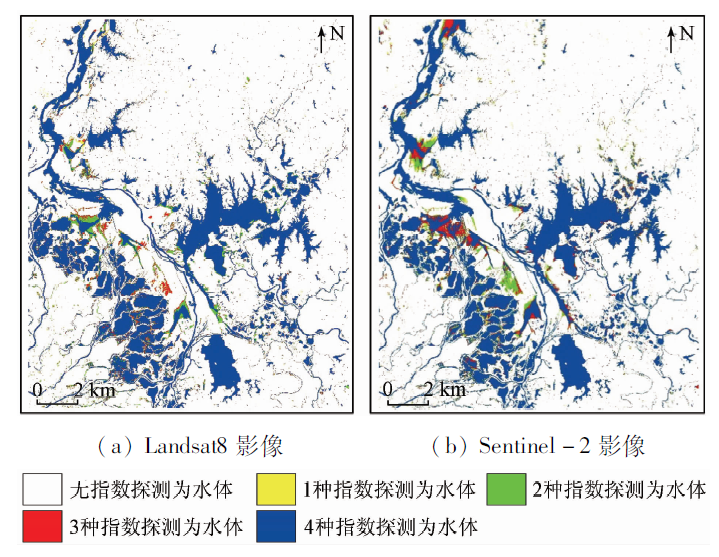
Abstract Extracting surface water like lake water areas from satellite images quickly and accurately has been an important research topic, which is of great significance to the water disaster monitoring and water resource management. Sentinel-2 multi spectral imager (MSI) and Landsat8 operational land imager (OLI) data are two popular medium- to high- resolution data sources that are freely available. Using the Poyang Lake as the study area and employing four popular water indices, i.e., normalized difference water index (NDWI), modified normalized difference water index (MNDWI), automatic water extraction index (AWEIsh) and water index created with linear discriminant analysis (WI2015), the authors extracted water distribution from two types of images respectively. Water extraction results derived from different images and different water indices were analyzed. The accuracy of the water extraction results was evaluated by visual interpretation results of corresponding GF-1 images. The results reveal that, for these two remote sensing images, all water indices can detect most water body successfully. Among these indices, AWEIsh and WI2015 have relatively higher extraction accuracy, reaching 98% and 94% respectively on Sentinel-2 and Landsat8 images. Compared with Landsat8 images, Sentinel-2 images are capable of reflecting more detailed water body information, and the overall extraction accuracy is higher.
|
| Keywords
Sentinel-2
Landsat8
NDWI
MNDWI
AWEIsh
WI2015
|
|
|
|
Corresponding Authors:
Chang HUANG
E-mail: changh@nwu.edu.cn
|
|
Issue Date: 30 August 2019
|
|
|
| [1] |
Famiglietti J S, Rodell M . Water in the balance[J]. Science, 2013,340(6138):1300-1301.
|
| [2] |
Du Y, Xue H P, Wu S J , et al. Lake area changes in the middle Yangtze region of China over the 20th century[J]. Journal of Environmental Management, 2011,92(4):1248-1255.
|
| [3] |
Feng M, Sexton J O, Channan S , et al. A global,high-resolution (30-m) inland water body dataset for 2000:First results of a topo-graphic-spectral classification algorithm[J]. International Journal of Digital Earth, 2016,9(2):113-133.
|
| [4] |
Liao A P, Chen L J, Chen J , et al. High-resolution remote sensing mapping of global land water[J]. Science China Earth Sciences, 2014,57(10):2305-2316.
|
| [5] |
Carroll M L, Townshend J R, Dimiceli C M , et al. A new global raster water mask at 250 m resolution[J]. International Journal of Digital Earth, 2009,2(4):291-308.
|
| [6] |
刘桂林, 张落成, 刘剑 , 等. 基于Landsat TM影像的水体信息提取[J]. 中国科学院大学学报, 2013,30(5):644-650.
doi: 10.7523/j.issn.2095-6134.2013.05.011
|
| [6] |
Liu G L, Zhang L C, Liu J , et al. Water bodies information extraction based on Landsat TM remote sensing imagery[J]. Journal of University of Chinese Academy of Sciences, 2013,30(5):644-650.
|
| [7] |
胡兵, 杨敏华, 刘璇 . 基于LBV变换与多分辨率分析的水体提取研究[J]. 测绘地理信息, 2011,36(5):20-22.
|
| [7] |
Hu B, Yang M H, Liu X . Water body extracting based on LBV transformation and multi-resolution analysis[J]. Journal of Geomatics, 2011,36(5):20-22.
|
| [8] |
丁凤 . 基于新型水体指数(NWI)进行水体信息提取的实验研究[J]. 测绘科学, 2009,34(4):155-157.
|
| [8] |
Ding F . Study on information extraction of water body with a new water index (NWI)[J]. Science of Surveying and Mapping, 2009,34(4):155-157.
|
| [9] |
徐涵秋, 唐菲 . 新一代Landsat系列卫星:Landsat8遥感影像新增特征及其生态环境意义[J]. 生态学报, 2013,33(11):3249-3257.
doi: 10.5846/stxb201305030912
url: http://doi.med.wanfangdata.com.cn/10.5846/stxb201305030912
|
| [9] |
Xu H Q, Tang F . Analysis of new characteristics of the first Landsat8 image and their eco-environmental significance[J]. Acta Ecologica Sinica, 2013,33(11):3249-3257.
|
| [10] |
Drusch M, Bello U D, Carlier S , et al. Sentinel-2:ESA’s optical high-resolution mission for GMES operational services[J]. Remote Sensing of Environment, 2012,120(1):25-36.
|
| [11] |
Lu S, Wu B, Yan N , et al. Water body mapping method with HJ-1A/B satellite imagery[J]. International Journal of Applied Earth Observations and Geoinformation, 2011,13(3):428-434.
|
| [12] |
杨莹, 阮仁宗 . 基于TM影像的平原湖泊水体信息提取的研究[J]. 遥感信息, 2010,3:60-64.
|
| [12] |
Yang Y, Ruan R Z . Extraction of plain lake water body based on TM imagery[J]. Remote Sensing Information, 2010,3:60-64.
|
| [13] |
殷青军, 杨英莲 . 基于EOS/MODIS数据的青海湖遥感监测[J]. 湖泊科学, 2005,17(4):356-360.
|
| [13] |
Yin Q J, Yang Y L . Remote sensing monitoring of Lake Qinghai based on EOS/MODIS data[J]. Journal of Lake Sciences, 2005,17(4):356-360.
|
| [14] |
张明华 . 用改进的谱间关系模型提取极高山地区水体信息[J]. 地理与地理信息科学, 2008,24(2):14-16,22.
|
| [14] |
Zhang M H . Extracting water-body information with improved medal of spectral relationship in a higher mountain area[J]. Geography and Geo-Information Science, 2008,24(2):14-16,22.
|
| [15] |
熊金国, 王世新, 周艺 . 不同指数模型提取ALOS AVNIR-2影像中水体的敏感性和精度分析[J]. 国土资源遥感, 2010,22(4):46-50.doi: 10.6046/gtzyyg.2010.04.10.
doi: 10.6046/gtzyyg.2010.04.10
|
| [15] |
Xiong J G, Wang S X, Zhou Y . A sensitivity analysis and accuracy assessment of different water extraction index models based on ALOS AVNIR-2 data[J]. Remote Sensing for Land and Resources, 2010,22(4):46-50.doi: 10.6046/gtzyyg.2010.04.10.
|
| [16] |
王秋燕, 陈仁喜, 徐佳 , 等. 环境一号卫星影像中水体信息提取方法研究[J]. 科学技术与工程, 2012,12(13):3051-3056.
|
| [16] |
Wang Q Y, Chen R X, Xu J , et al. Research on methods for extracting water body information from HJ-1A/B data[J]. Science Technology and Engineering, 2012,12(13):3051-3056.
|
| [17] |
李博, 周新志 . 基于MODIS数据的川西山区河道水体提取方法研究[J]. 地理与地理信息科学, 2009,25(2):59-62.
|
| [17] |
Li B, Zhou X Z . Research on extraction method of river water-body in mountain area of western Sichuan based on MODIS data[J]. Geography and Geo-Information Science, 2009,25(2):59-62.
|
| [18] |
曹荣龙, 李存军, 刘良云 , 等. 基于水体指数的密云水库面积提取及变化监测[J]. 测绘科学, 2008,33(2):158-160.
|
| [18] |
Cao R L, Li C J, Liu L Y , et al. Extracting Miyun reservoir’s water area and monitoring its change based on a revised normalized different water index, 2008,33(2):158-160.
|
| [19] |
陈杰 . 高分辨率遥感影像面向对象分类方法研究[D]. 中南大学, 2010.
|
| [19] |
Chen J . An Object-Oriented Classification Method for High Resolution Remote Sensing Imagery[D]. Changsha:Central South University, 2010.
|
| [20] |
Shih S F . Comparison of ELAS classification and density slicing Landsat data for water-surface area assessment[J]. Hydrologic Applications of Space Technology, 1985,160:91-97.
|
| [21] |
Barton I J, Bathols J M . Monitoring floods with AVHRR[J]. Remote Sensing of Environment, 1989,30(1):89-94.
|
| [22] |
陆家驹, 李士鸿 . TM资料水体识别技术的改进[J]. 遥感学报, 1992,1:17-23.
|
| [22] |
Lu J J, Li S H . Improvement of the techniques for distinguishing water bodies from TM data[J]. Journal of Remote Sensing, 1992,1:17-23.
|
| [23] |
McFeeters S K . The use of the normalized difference water index (NDWI) in the delineation of open water features[J]. International Journal of Remote Sensing, 1996,17(7):1425-1432.
|
| [24] |
徐涵秋 . 利用改进的归一化差异水体指数(MNDWI)提取水体信息的研究[J]. 遥感学报, 2005,9(5):589-595.
doi: 10.3321/j.issn:1007-4619.2005.05.012
url: http://d.wanfangdata.com.cn/Periodical/ygxb200505012
|
| [24] |
Xu H Q . A study on information extraction of water body with the modified normalized difference water index (MNDWI)[J]. Journal of Remote Sensing, 2005,9(5):589-595.
|
| [25] |
Feyisa G L, Meilby H, Fensholt R , et al. Automated water extraction index:A new technique for surface water mapping using Landsat imagery[J]. Remote Sensing of Environment, 2014,140(1):23-35.
|
| [26] |
Danaher T, Collett L . Development,optimisation and multi-temporal application of a simple Landsat based water index [C]//The 13th Australasian Remote Sensing and Photogrammetry Conference.Canberra, 2006.
|
| [27] |
Fisher A, Flood N, Danaher T . Comparing Landsat water index methods for automated water classification in eastern Australia[J]. Remote Sensing of Environment, 2016,175:167-182.
|
| [28] |
Xu H Q . Modification of normalised difference water index (NDWI) to enhance open water features in remotely sensed imagery[J]. International Journal of Remote Sensing, 2006,27(14):3025-3033.
|
| [29] |
Ji L, Zhang L, Wylie B . Analysis of dynamic thresholds for the normalized difference water index[J]. Photogrammetric Engineering and Remote Sensing, 2009,75(11), 1307-1317.
|
| [30] |
Huang C, Chen Y, Zhang S , et al. Detecting,extracting,and monitoring surface water from space using optical sensors:A review[J]. Reviews of Geophysics, 2018,56:333-360.
|
| [31] |
Liu Y, Song P, Peng J , et al. A physical explanation of the variation in threshold for delineating terrestrial water surfaces from multi-temporal images:Effects of radiometric correction[J]. International Journal of Remote Sensing, 2012,33(18):5862-5875.
|
|
Viewed |
|
|
|
Full text
|
|
|
|
|
Abstract
|
|
|
|
|
Cited |
|
|
|
|
| |
Shared |
|
|
|
|
| |
Discussed |
|
|
|
|
 2019,
Vol. 31
2019,
Vol. 31
 )
)