|
|
 |
|

|
|
|
Extraction of geological structural and alteration information and the prediction of metallogenic favorable locations in northeastern Jeddah, Saudi Arabia |
| Honglin MA1,2, Weijie JIA1,3, Changliang FU1, Wei LI1 |
1. China Aero Geophysical Survey and Remote Sensing Center for Natural Resources, Beijing 100083, China
2. School of Earth Sciences and Resources, China University of Geosciences(Beijing), Beijing 100083,China
3. University of Chinese Academy of Sciences, Beijing 100049, China |
|
|
|
|
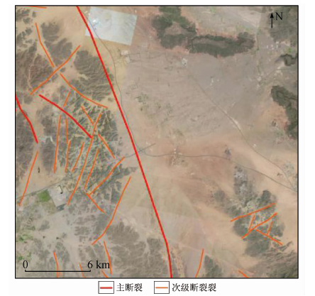
Abstract Northeastern Jeddah area of Saudi Arabia is located in Africa-Arab metallogenic area, which is characterized by rich mineral resources, complex geological structure and magmatic hydrothermal activities, thus having well-developed polymetallic mineralization and tremendous metallogenic potential. For the purpose of further prospecting for polymetallic areas and delineating favorable targets, the authors used the Landsat8 images to interpret linear-ring structures in the whole study area, and employed the “principal component analysis-optimal density segmentation” method by using iron mineralization alteration anomaly to extract polymetallic deposits. Based on the comprehensive analysis, the authors studied the remote sensing image geological characteristics of 7 iron mineralization alteration zones in the study area and selected favorable metallogenic linear-ring structures to predict the favorable location of prospecting in the northeastern Jeddah area of Saudi Arabia. Three iron prospective areas were delineated. GF-2 and Google Earth images were used to verify the prediction of metallogenic favorable sites in northeastern Jeddah of Saudi Arabia. The results obtained further prove that the magmatic intrusion in the annular tectonic zone and the fracture junction are favorable places for metallogenesis in the study area. The results obtained by the authors could provide the reference for the further prospecting prediction in this region.
|
| Keywords
linear-ring structure
alteration anomaly
optimal density segmentation
prospecting prediction
northeastern Jeddah
|
|
|
|
Issue Date: 30 August 2019
|
|
|
| [1] |
邹晓峰 . 遥感技术在地质工作中的应用[J]. 中国井矿盐, 2018,49(2):33-34.
|
| [1] |
Zou X F . The application of remote sensing technology in geological work[J]. China Well and Rock Salt, 2018,49(2):33-34.
|
| [2] |
郑雄伟, 杨金中, 陈玲 , 等. 国土资源卫星地质矿产应用成效[J]. 国土资源遥感, 2017,29(s1):1-7.doi: 10.6046/gtzyyg.2017.s1.01.
|
| [2] |
Zheng X W, Yang J Z, Cheng L , et al. A review on the effects of appling land and resources satellites to geology and mineral resources[J]. Remote Sensing for Land and Resources, 2017,29(s1):1-7.doi: 10.6046/gtzyyg.2017.s1.01.
|
| [3] |
赵英时 . 遥感应用分析原理与方法[M]. 北京: 科学出版社, 2003.
|
| [3] |
Zhao Y S. Analysis Principle and Method of Remote Sensing Application[M]. Beijing: Science Press, 2003.
|
| [4] |
王瑞军, 闫柏琨, 李名松 , 等. 甘肃红山地区重要控矿地质单元GF-1数据遥感解译与应用[J]. 国土资源遥感, 2018,30(2):162-170.doi: 10.6046/gtzyyg.2018.02.22.
|
| [4] |
Wang R J, Yan B K, Li M S , et al. Remote sensing interpretation of important ore-controlling geological units in Hongshan region of Gansu Province using GF-1 image and its application[J]. Remote Sensing for Land and Resources, 2018,30(2):162-170.doi: 10.6046/gtzyyg.2018.02.22.
|
| [5] |
王超 . 地质构造与遥感蚀变的相关性分析[J]. 产业与科技论坛, 2018,17(8):53-54.
|
| [5] |
Wang C . Correlation analysis of geological structure and remote sensing alteration[J]. Industrial and Science Tribune, 2018,17(8):53-54.
|
| [6] |
张志军, 潘思远, 李明 , 等. 北巴颜喀拉山地区岩性遥感解译标志建立[J]. 国土资源遥感, 2017,29(1):199-207.doi: 10.6046/gtzyyg.2017.01.30.
|
| [6] |
Zhang Z J, Pan S Y, Li M , et al. Establishment of lithological remote sensing interpretation keys in north Bayan Hara Mountain[J]. Remote Sensing for Land and Resources, 2017,29(1):199-207.doi: 10.6046/gtzyyg.2017.01.30.
|
| [7] |
颜林 . 地质矿产勘查遥感找矿技术分析[J].世界有色金属, 2017(23):107-108.
|
| [7] |
Yan L . Analysis of remote sensing prospecting technology for geological and mineral exploration[J].World Nonferrous Metals, 2017(23):107-108.
|
| [8] |
苗中杰, 申维, 荆林海 , 等. 新疆西昆仑甜水海—羚羊滩地区铅锌矿遥感找矿模型构建及成矿预测[J].金属矿山, 2017(8):138-145.
|
| [8] |
Miao Z J, Shen W, Jin L H , et al. Establishment of remote sensing prospecting model and metallogenic prediction of Pb-Zn deposit in Tianshuihai-Lingyangtan area,west Kunlun,Xinjiang[J].Metal Mine, 2017(8):138-145.
|
| [9] |
许文文, 成功, 鲁裕民 , 等. 马达加斯加索菲亚省BINARA地区铬铁矿遥感找矿预测[J]. 地质找矿论丛, 2018,33(1):108-114.
|
| [9] |
Xu W W, Cheng G, Lu Y M , et al. Remote sensing prospecting prediction about chromite in BINARA area of Sophia Province,Madagascar[J]. Contributions to Geology and Mineral Resources Research, 2018,33(1):108-114.
|
| [10] |
张元厚, 毛景文, 李宗彦 , 等. 岩浆热液系统中矿床类型、特征及其在勘探中的应用[J]. 地质学报, 2009,83(3):399-425.
|
| [10] |
Zhang Y H, Mao J W, Li Z Y , et al. Ore deposit types and characteristics of magmatic-hydrothermal systems and implication for exploration[J]. Acta Geologica Sinica, 2009,83(3):399-425.
|
| [11] |
赵宏峰 . 浅谈遥感解译中断裂构造的解译方法及解译标志[J].世界有色金属, 2016(7):64-65.
|
| [11] |
Zhao H F . On the interpretation method of fault structure in remote sensing interpretation and its solution[J].World Nonferrous Metals, 2016(7):64-65.
|
| [12] |
张晓亮, 郑国庆, 方同明 . 北京市遥感矿产地质构造解译与异常提取初步分析[J]. 城市地质, 2012,7(1):26-30.
|
| [12] |
Zhang X L, Zheng G Q, Fang T M . Preliminary study on the anomaly extraction of remote sensing interpretation about Beijing mineral resources and geological structure[J]. City Geology, 2012,7(1):26-30.
|
| [13] |
余晓霞, 高建国, 潘亚茹 , 等. 阿斯哈—按纳格地区线-环构造与有利成矿关系分析[J]. 国土资源遥感, 2015,27(3):128-135.doi: 10.6046/gtzyyg.2015.03.21.
doi: 10.6046/gtzyyg.2015.03.21
|
| [13] |
Yu X X, Gao J G, Pan Y R , et al. Analysis of line-ring structure and favorable relationships to mineraliztion in area from Asiha to Annage[J]. Remote Sensing for Land and Resources, 2015,27(3):128-135.doi: 10.6046/gtzyyg.2015.03.21.
|
| [14] |
史超, 李书, 任正情 , 等. 三维遥感影像在遥感地质构造解译中的应用——以福建平和植被覆盖区为例[J]. 地质找矿论丛, 2016,31(1):127-134.
|
| [14] |
Shi C, Li S, Ren Z Q , et al. The application of 3D remote sensing image in the interpretation of geological structure:A case of vegetation covered Pinghe area,Fujian[J]. Contributions to Geology and Mineral Resources Research, 2016,31(1):127-134.
|
| [15] |
莫测辉, 冯志文, 夏卫华 , 等. 江西银山金铜多金属矿床构造动力热液与火山岩浆热液双重藕合成矿作用[J]. 江西地质, 1995,9(2):93-102
|
| [15] |
Mo C H, Feng Z W, Xia W H , et al. Yinshan Au-Cu polymetallic ore deposit double coupling mineralization of tectono-dynamic and volcano-mangmatic hydrothermal solution[J]. Geology of Jiangxi, 1995,9(2):93-102.
|
| [16] |
杨梅珍, 陆建培, 付静静 , 等. 桐柏山老湾金矿带与燕山期岩浆作用有关的岩浆热液金多金属矿床成矿作用——来自地球化学、年代学证据及控矿构造地质约束[J]. 矿床地质, 2014,33(3):651-666.
|
| [16] |
Yang M Z, Lu J P, Fu J J , et al. Magmatic hydrothermal gold and polymetallic metallogenesis related to Yanshanian magmatism of Laowan gold belt,Tongbai Mountain:Evidence from geochemistry,geochronology and ore-controlling structural geological constraints[J]. Mineral Deposites, 2014,33(3):651-666.
|
| [17] |
杨金中, 方洪宾, 张玉君 , 等. 中国西部重要成矿带遥感找矿异常提取的方法研究[J]. 国土资源遥感, 2003,15(3):50-53.doi: 10.6046/gtzyyg.2003.03.12.
doi: 10.6046/gtzyyg.2003.03.12
|
| [17] |
Yang J Z, Fang H B, Zhang Y J , et al. Remote sensing anomaly extraction in important metallogenic belts of western China[J]. Remote Sensing for Land and Resources, 2003,15(3):50-53.doi: 10.6046/gtzyyg.2003.03.12.
|
| [18] |
张玉君, 杨建民 . 基岩裸露区蚀变岩遥感信息的提取方法[J]. 国土资源遥感, 1998,10(2):46-53.doi: 10.6046/gtzyyg.1998.02.07.
doi: 10.6046/gtzyyg.1998.02.07
|
| [18] |
Zhang Y J, Yang J M . The method of abstracting remote sensing information of alterated rocks in the uncovered bedrocks area[J]. Remote Sensing for Land and Resources, 1998,10(2):46-53.doi: 10.6046/gtzyyg.1998.02.07.
|
| [19] |
杨德生, 程钢, 卢小平 . 遥感地质解译及矿化蚀变信息提取在矿产资源评价中的应用研究[J]. 河南理工大学学报(自然科学版), 2010,29(2):184-189.
|
| [19] |
Yang D S, Cheng G, Lu X P . Application of geological interpretation and mineralization information extracting by remote-sensing in mineral resource evaluating[J]. Journal of Henan Polytechnic University(Natural Science), 2010,29(2):184-189.
|
| [20] |
陈利燕 . 最优密度分割法在西昆仑遥感蚀变提取中的应用[J]. 安徽农业科学, 2009,37(25):12144-12145.
|
| [20] |
Chen L Y . Application of optimal density segmentation in the remote sensing alteration extraction in west Kunlun Mountain[J]. Journal of Anhui Agricultural Sciences, 2009,37(25):12144-12145.
|
| [21] |
吴德文, 张远飞, 朱谷昌 . 遥感图像岩石信息提取的最优密度分割方法[J]. 国土资源遥感, 2002,14(4):51-54.doi: 10.6046/gtzyyg.2002.04.11.
doi: 10.6046/gtzyyg.2002.04.11
|
| [21] |
Wu D W, Zhang Y F, Zhu G C . The best density separation method for extracting rock information from remote sensing image[J]. Remote Sensing for Land and Resources, 2002,14(4):51-54.doi: 10.6046/gtzyyg.2002.04.11.
|
| [22] |
梅燕雄, 裴荣富, 杨德凤 , 等. 全球成矿域和成矿区带[J]. 矿床地质, 2009,28(4):383-389.
|
| [22] |
Mei Y X, Pei R F, Yang D F , et al. Global metallogenic domains and districts[J]. Mineral Deposits, 2009,28(4):383-389.
|
| [23] |
Roobol M J, Ramsay C R, Jackson N J , et al. Late Proterozoic lavas of the Central Arabian Shield—evolution of an ancient volcanic arc system[J]. Journal of the Geological Society, 1983,140(2):185-202.
|
|
Viewed |
|
|
|
Full text
|
|
|
|
|
Abstract
|
|
|
|
|
Cited |
|
|
|
|
| |
Shared |
|
|
|
|
| |
Discussed |
|
|
|
|
 2019,
Vol. 31
2019,
Vol. 31