|
|
|
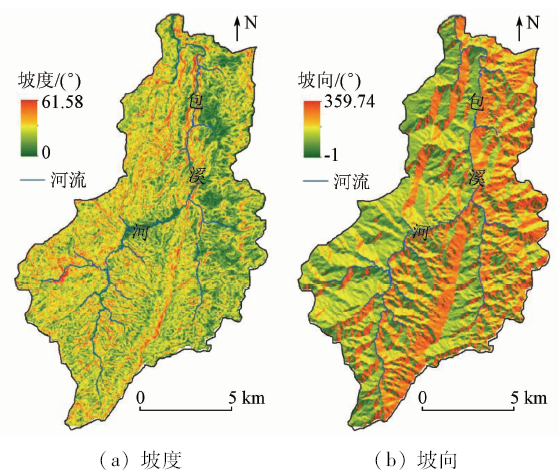
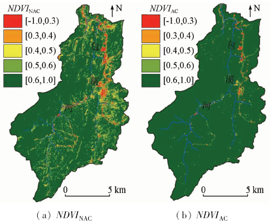
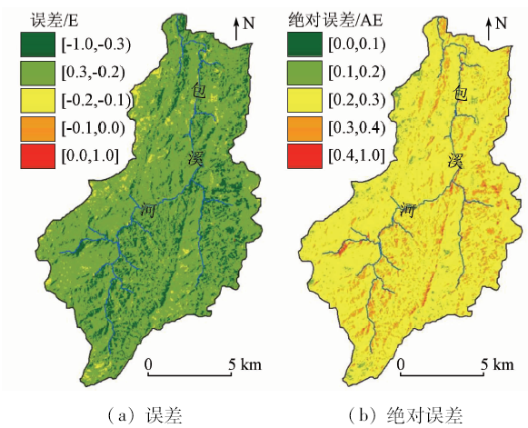
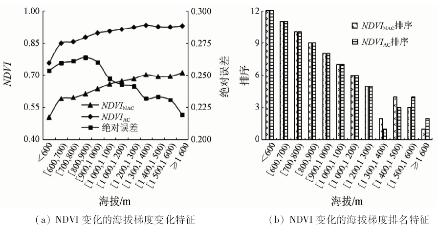
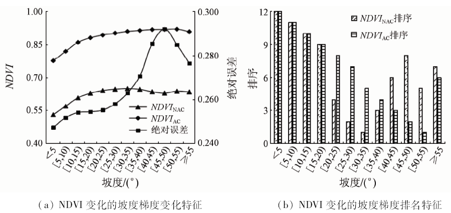
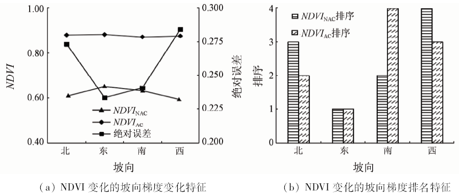
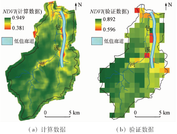
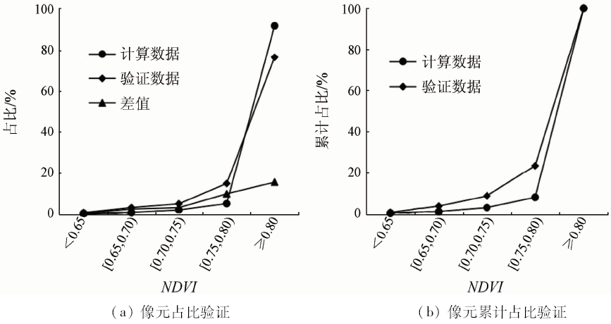
Abstract Atmospheric correction is an important part of remote sensing image processing. It is of theoretical significance to explore the characteristics of normalized difference vegetation index (NDVI) and its terrain gradient before and after atmospheric correction. This paper draws the following conclusions: ① The NDVI obtained without atmospheric correction is generally underestimated in space. ② The NDVI obtained without atmospheric correction cannot reflect the trend and proportional relationship of each stage. The NDVI without atmospheric correction has serious deviation, and the NDVI is more than 0.6. The absolute error is over 20%. ③ Whether the atmospheric correction is made or not affects the NDVI change trend and the numerical value of each altitude; the absolute error increases below 1 000 m, and the absolute error fluctuation decreases thereafter. ④ Whether the atmospheric correction is made or not has an effect on the slope NDVI trend and value; as the slope increases, the absolute error first rises and then falls, and the slope (45°, 50° ) absolute error is the largest. ⑤ Whether the atmospheric correction is made or not has an effect on the NDVI trend of each slope; the absolute error of west slope is the largest, and the east slope is the smallest.
|
| Keywords
NDVI
terrain gradient effect
atmospheric correction
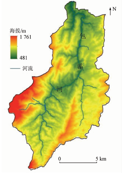
Baoxi River Basin
mountain basin
|
|
|
|
Corresponding Authors:
Xudong LI
E-mail: 616507732@qq.com
|
|
Issue Date: 14 March 2020
|
|
|
| [1] |
李卫国, 蒋楠, 王纪华 . 基于薄云雾去除的ETM+影像大气校正[J]. 农业工程学报, 2013,29(s1):82-88.
|
| [1] |
Li W G, Jiang N, Wang J H . Atmospheric correction for ETM+ image based on thin cloud removal[J]. Transactions of the Chinese Society of Agricultural Engineering, 2013,29(s1):82-88.
|
| [2] |
刘耀林, 赵翔, 马潇雅 , 等. TM/ETM+影像大气校正产品质量评价方法研究[J]. 测绘学报, 2012,41(4):549-555.
|
| [2] |
Liu Y L, Zhao X, Ma X Y , et al. Research on quality assessment of atmospheric correction products retrieved from TM /ETM+ imagery[J]. Acta Geodaetica et Cartographica Sinica, 2012,41(4):549-555.
|
| [3] |
周雪欣, 罗昊 . 基于GIS与RS技术的北盘江流域生态环境质量评价研究[J]. 环境科学与管理, 2018,43(7):178-182.
|
| [3] |
Zhou X X, Luo H . Ecological environment quality assessment of Beipanjiang Basin based on GIS and remote sense[J]. Environmental Science and Management, 2018,43(7):178-182.
|
| [4] |
吴端耀, 罗娅, 王青 , 等. 2001—2014年贵州省林草植被覆盖度时空变化及其与气温降水变化的关系[J]. 贵州师范大学学报(自然科学版), 2017,35(1):1-7,29.
|
| [4] |
Wu D Y, Luo Y, Wang Q , et al. Spatio-temporal variation of vegetation coverage in forest and grassland and its relationship with temperature and precipitation changes in Guizhou Province during 2001—2014[J]. Journal of Guizhou Normal University (Natural Sciences), 2017,35(1):1-7,29.
|
| [5] |
江颖慧, 焦利民, 张博恩 . 城市地表温度与NDVI空间相关性的尺度效应[J]. 地理科学进展, 2018,37(10):1362-1370
|
| [5] |
Jiang Y H, Jiao L M, Zhang B E . Scale effect of the spatial correlation between urban land surface temperature and NDVI[J]. Progress in Geography, 2018,37(10):1362-1370.
|
| [6] |
王涛, 田阳, 相如 . 不同NDVI年值提取方法对秦岭山地植被变化及其气候响应的影响[J]. 北方园艺, 2017(24):148-155.
|
| [6] |
Wang T, Tian Y, Xiang R . Impact of different extracted methods of annual NDVI on vegetation cover change and their response to climate change in Qinling Mountains[J]. Northern Horticulture, 2017(24):148-155.
|
| [7] |
廖顺宝, 岳艳琳 . 基于时序NDVI图谱库提高土地覆盖分类精度的方法[J]. 农业工程学报, 2018,34(7):241-248.
|
| [7] |
Liao S B, Yue Y L . Method of improving classification accuracy of land cover based on time series NDVI database[J]. Transactions of the Chinese Society of Agricultural Engineering, 2018,34(7):241-248.
|
| [8] |
刘建文, 周玉科 . 站点尺度的青藏高原时序NDVI重构方法比较与应用[J]. 地理科学进展, 2018,37(3):427-437.
|
| [8] |
Liu J W, Zhou Y K . Comparison and application of NDVI time-series reconstruction methods at site scale on the Tibetan Plateau[J]. Progress in Geography, 2018,37(3):427-437.
|
| [9] |
王学成, 杨飞, 高星 , 等. 基于NDVI阈值法的森林冰冻受灾范围精确提取[J]. 地球信息科学学报, 2017,19(4):549-558.
|
| [9] |
Wang X C, Yang F, Gao X , et al. Precise extraction of damaged forest range caused by ice-snow frozen disaster based on the NDVI threshold method[J]. Journal of Geo-Information Science, 2017,19(4):549-558.
|
| [10] |
郝震, 赵红莉, 蒋云钟 . 基于改进的NDVI密度分割方法的冬小麦面积信息提取[J]. 南水北调与水利科技, 2017,15(3):67-72,93.
|
| [10] |
Hao Z, Zhao H L, Jiang Y Z . Extraction of winter wheat area information based on the improved NDVI density slicing method[J]. South-to-North Water Transfers and Water Science and Technology, 2017,15(3):67-72,93.
|
| [11] |
徐新良 . 中国月度植被指数(NDVI)空间分布数据集[Z/OL]. 北京: 中国科学院资源环境科学数据中心数据注册与出版系统( http://www.resdc.cn/DOI), 2018.doi: 10.12078/2018060602.
url: http://www.resdc.cn/DOI
|
| [11] |
Xu X L. China monthly vegetation index (NDVI) spatial distribution data set[Z/OL]. Beijing: Chinese Academy of Sciences Resource and Environmental Science Data Center Data Registration and Publishing System( http://www.resdc.cn/DOI), 2018.doi: 10.12078/2018060602.
url: http://www.resdc.cn/DOI
|
| [12] |
尹红, 吕红梅, 杨广斌 . 基于CBERS02的毕节地区植被覆盖信息提取技术研究[J]. 贵州师范大学学报(自然科学版), 2009,27(2):43-45.
|
| [12] |
Yin H, Lyu H M, Yang G B . A study of extracting vegetation coverage in Bijie prefecture based on CBERS02 image[J]. Journal of Guizhou Normal University (Natural Sciences), 2009,27(2):43-45.
|
| [13] |
姚镇海, 邱新法, 施国萍 , 等. 我国近10年月平均NDVI空间分布特征分析[J]. 国土资源遥感, 2017,29(2):181-186.doi: 10.6046/gtzyyg.2017.02.26.
|
| [13] |
Yao Z H, Qiu X F, Shi G P , et al. An analysis of spatial distribution characteristics of monthly mean NDVI in the past ten years in China[J]. Remote Sensing of Land and Resources, 2017,29(2):181-186.doi: 10.6046/gtzyyg.2017.02.26.
|
|
Viewed |
|
|
|
Full text
|
|
|
|
|
Abstract
|
|
|
|
|
Cited |
|
|
|
|
| |
Shared |
|
|
|
|
| |
Discussed |
|
|
|
|
 2020,
Vol. 32
2020,
Vol. 32
 )
)