|
|
 |
|

|
|
|
Study of ore control information in Rongle area of Tibet based on high resolution remote sensing data |
| Lihua FU, Ce ZHANG |
| Airborne Survey and Remote Sensing Center of Nuclear Industry, Shijiazhuang 050002, China |
|
|
|
|
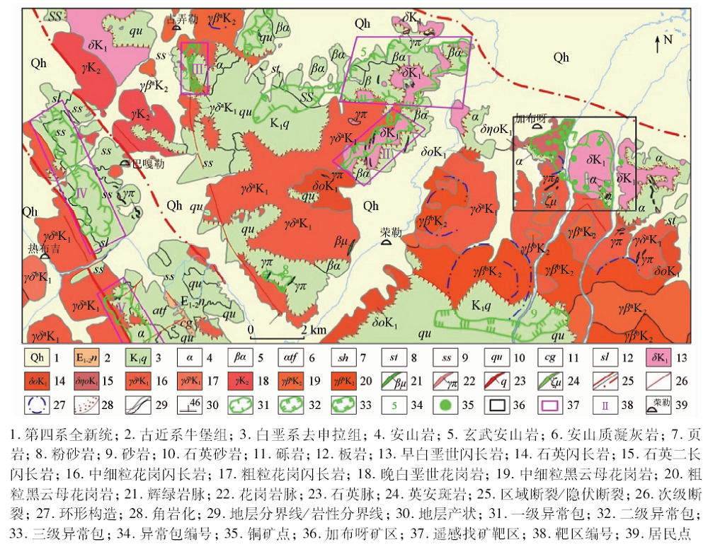
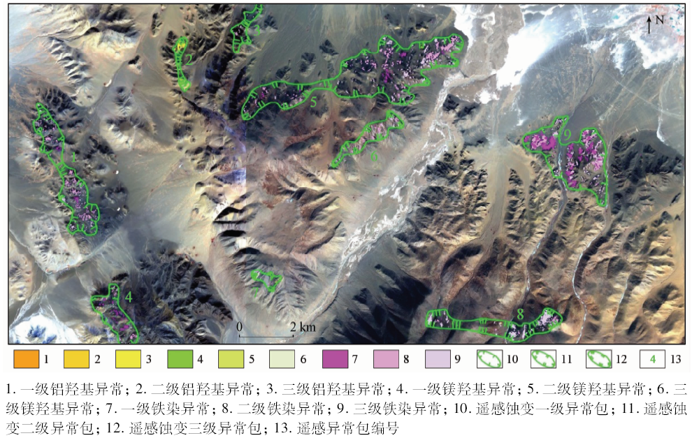
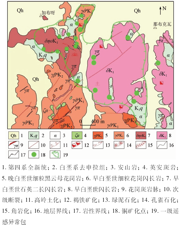
Abstract High-resolution remote sensing data have rich information and hence can be used to better identify micro-lithology, structure and other ore-controlling information. In order to study the extraction of ore-controlling information of high-resolution remote sensing data in Rongle area of Tibet where the elevation is high and the bedrock is exposed, the authors interpreted the ore-controlling information of strata, lithology, rock mass, structure, contact zone and other information closely related to copper polymetallic mineralization in this area on the basis of the best band combination determined by WorldView-2 high-resolution remote sensing data. Using ASTER data, the authors employed principal component analysis (PCA) to extract the mineralization-related remote sensing alteration information of iron stain, aluminum hydroxyl group and magnesium hydroxyl group. Based on comprehensive regional copper mineralization rules, the authors constructed a remote sensing prospecting model for ore-controlling information of magmatic hydrothermal copper deposits through human-computer interaction interpretation. Five prospecting targets were delineated and good mineralization clues were found through field investigation. The results provide basic information and reference basis for promoting local prospecting process. The results show that the high-resolution remote sensing data can meet the needs of mineral resources exploration and resource evaluation in the high-altitude environment hostile areas in Western China and highlight the fast, efficient and reliable application effect of high-resolution remote sensing.
|
| Keywords
high resolution remote sensing
ore control information
prospecting applications
Rongle area
|
|
|
|
Issue Date: 14 March 2020
|
|
|
| [1] |
张志军, 潘思远, 李明 , 等. 北巴颜喀拉山地区岩性遥感解译标志建立[J]. 国土资源遥感, 2017,29(1):199-207.doi: 10.6046/gtzyyg.2017.01.30.
|
| [1] |
Zhang Z J, Pan S Y, Li M , et al. Establishment of lithological remote sensing interpretation keys in north Bayan Hara Mountain[J]. Remote Sensing for Land and Resources, 2017,29(1):199-207.doi: 10.6046/gtzyyg.2017.01.30.
|
| [2] |
张微, 金谋顺, 张少鹏 , 等. 高分遥感卫星数据在东昆仑成矿带找矿预测中的应用[J]. 国土资源遥感, 2016,28(2):112-119.doi: 10.6046/gtzyyg.2016.02.18.
|
| [2] |
Zhang W, Jin M S, Zhang S P , et al. Application of high resolution remote sensing data to ore-prospecting prediction in East Kunlun metallogenic belt[J]. Remote Sensing for Land and Resources, 2016,28(2):112-119.doi: 10.6046/gtzyyg.2016.02.18.
|
| [3] |
付丽华, 张策, 魏本赞 , 等. 西藏达朵希巴地区成矿条件分析及遥感找矿预测[J]. 矿产勘查, 2015,6(5):535-541.
|
| [3] |
Fu L H, Zhang C, Wei B Z , et al. Analysis of metallogenic conditions and prospecting prediction by remote sensing technology in Daduoxiba area,Tibet[J]. Mineral Exploration, 2015,6(5):535-541.
|
| [4] |
张云峰, 李领军, 冯淳 . ASTER数据在北方铝土矿预普查中的应用——以豫西渑池地区为例[J]. 国土资源遥感, 2012,24(1):48-52.doi: 10.6046/gtzyyg.2012.01.09.
|
| [4] |
Zhang Y F, Li L J, Feng C . The application of ASTER data to bauxite deposit pre-survey in Northern China:A case study of Mianchi area,Western Henan[J]. Remote Sensing for Land and Resources, 2012,24(1):48-52.doi: 10.6046/gtzyyg.2012.01.09.
|
| [5] |
韩海辉, 王艺霖, 任广利 , 等. 基于ASTER数据的北山方山口地区蚀变矿物提取与找矿应用[J]. 遥感技术与应用, 2016,31(2):368-377.
|
| [5] |
Han H H, Wang Y L, Ren G L , et al. Extraction and application of altered mineral in prospecting from ASTER data in Fangshankou,Beishan[J]. Remote Sensing Technology and Application, 2016,31(2):368-377.
|
| [6] |
杨金中, 赵玉灵 . 遥感技术的特点及其在地质矿产调查中的作用[J]. 矿产勘查, 2015,6(5):529-534.
|
| [6] |
Yang J Z, Zhao Y L . Technical features of remote sensing and its application in the geological survey and mineral resources survey[J]. Mineral Exploration, 2015,6(5):529-534.
|
| [7] |
付丽华, 李名松, 王永军 , 等. 西藏玛那国地区遥感找矿预测[J]. 矿产勘查, 2015,6(2):171-177.
|
| [7] |
Fu L H, Li M S, Wang Y J , et al. Prospecting prediction by remote sensing approach in Managuo area,Tibet[J]. Mineral Exploration, 2015,6(2):171-177.
|
| [8] |
汪友明 . 革吉县幅(I44C004003)1∶25万区域地质调查报告[R]. 成都:四川省地质调查院, 2003.
|
| [8] |
Wang Y M . Geji County(I44C004003)1∶250 000 Regional Geological Survey Report[R]. Chengdu:Sichuan Geological Survey Institute, 2003.
|
| [9] |
王永军, 张策, 付丽华 , 等. 班公湖—怒江成矿带遥感地质调查成果报告[R]. 石家庄:核工业航测遥感中心, 2013.
|
| [9] |
Wang Y J, Zhang C, Fu L H , et al. Report on Remote Sensing Geological Survey Results of Bangonghu—Nujiang Metallogenic Belt[R]. Shijiazhuang:Airborne Survey and Remote Sensing Center of Nuclear Industry, 2013.
|
| [10] |
杨金中, 孙延贵, 秦绪文 , 等. 高分辨率遥感地质调查[M]. 北京: 测绘出版社, 2013: 45-47.
|
| [10] |
Yang J Z, Sun Y G, Qin X W , et al. High-Resolution Remote Sensing Geological Survey[M]. Beijing: Surveying and Mapping Publishing House, 2013: 45-47.
|
| [11] |
钱建平, 张渊, 赵小星 , 等. 内蒙古东乌旗遥感构造和蚀变信息提取与找矿预测[J]. 国土资源遥感, 2013,25(3):109-117.doi: 10.6046/gtzyyg.2013.03.19.
|
| [11] |
Qian J P, Zhang Y, Zhao X X , et al. Extraction of linear structure and alteration information based on remote sensing image and ore-prospecting prognosis for Dongwu Banner,Inner Mongolia[J]. Remote Sensing for Land and Resources, 2013,25(3):109-117.doi: 10.6046/gtzyyg.2013.03.19.
|
| [12] |
王瑞国 . 基于WorldView-2数据的乌东煤矿地质灾害遥感调查及成因分析[J]. 国土资源遥感, 2016,28(2):132-138.doi: 10.6046/gtzyyg.2016.02.21.
|
| [12] |
Wang R G . Remote sensing investigation and analysis of geological disasters in the Wudong coal mine based on WorldView-2 data[J]. Remote Sensing for Land and Resources, 2016,28(2):132-138.doi: 10.6046/gtzyyg.2016.02.21.
|
| [13] |
唐超, 陈建平, 张瑞丝 , 等. 基于ASTER遥感数据的班怒成矿带矿化蚀变信息提取[J]. 遥感技术与应用, 2013,28(1):122-128.
|
| [13] |
Tang C, Chen J P, Zhang R S , et al. Alteration from ASTER remote sensing data in Ban Nu metallogenic belt,Gaize,Tibet[J]. Remote Sensing Technology and Application, 2013,28(1):122-128.
|
| [14] |
范玉海, 王辉, 杨兴科 , 等. 基于高分辨率遥感数据的稀有金属矿化带勘查[J]. 国土资源遥感, 2018,30(1):128-134.doi: 10.6046/gtzyyg.2018.01.18.
|
| [14] |
Fan Y H, Wang H, Yang X K , et al. Application of high-resolution remote sensing technology to the prospecting for rare metal mineralization belt[J]. Remote Sensing for Land and Resources, 2018,30(1):128-134.doi: 10.6046/gtzyyg.2018.01.18.
|
| [15] |
夏清, 杨武年, 赵妮 . 青藏大陆北缘盆山耦合带库斯拉甫地区遥感蚀变信息提取[J]. 国土资源遥感, 2014,26(1):127-131.doi: 10.6046/gtzyyg.2014.01.22.
|
| [15] |
Xia Q, Yang W N, Zhao N . Extraction of remote sensing alteration information of Kosrap area in northern basin-mountain coupling zone of Tibetan Plateau[J]. Remote Sensing for Land and Resources, 2014,26(1):127-131.doi: 10.6046/gtzyyg.2014.01.22.
|
| [16] |
金谋顺, 王辉, 张微 , 等. 高分辨率遥感数据铁染异常提取方法及其应用[J]. 国土资源遥感, 2015,27(3):122-127.doi: 10.6046/gtzyyg.2015.03.20.
|
| [16] |
Jin M S, Wang H, Zhang W , et al. Method for extraction of ferric contamination anomaly from high-resolution remote sensing data and its applications[J]. Remote Sensing for Land and Resources, 2015,27(3):122-127.doi: 10.6046/gtzyyg.2015.03.20.
|
| [17] |
张志军, 甘甫平, 李贤庆 , 等. 基于ASTER数据的蚀变矿物信息提取——以哈密黄山铜镍矿区为例[J]. 国土资源遥感, 2012,24(2):85-91.doi: 10.6046/gtzyyg.2012.02.16.
|
| [17] |
Zhang Z J, Gan F P, Li X Q , et al. The extraction of altered mineral information based on ASTER data:A case study of the Huangshan copper-nickel ore district in Hami[J]. Remote Sensing for Land and Resources, 2012,24(2):85-91.doi: 10.6046/gtzyyg.2012.02.16.
|
| [18] |
别小娟, 张廷斌, 孙传敏 , 等. 藏东罗布莎蛇绿岩遥感岩矿信息提取方法研究[J]. 国土资源遥感, 2013,25(3):72-78.doi: 10.6046/gtzyyg.2013.03.13.
|
| [18] |
Bie X J, Zhang T B, Sun C M , et al. Study of methods for extraction of remote sensing information of rocks and altered minerals from Luobusha ophiolite in east Tibet[J]. Remote Sensing for Land and Resources, 2013,25(3):72-78.doi: 10.6046/gtzyyg.2013.03.13.
|
| [19] |
李伟 . 西藏改则地区去申拉组火山岩地球化学特征及锆石年代学制约[D]. 北京:中国地质大学(北京), 2012.
|
| [19] |
Li W . Geochemistry and Zircon U-Pb Chronology of Qushenla Group Volcanic in Cerze,Tibet[D]. Beijing:China University of Geosciences(Beijing), 2012.
|
| [20] |
曲晓明, 王瑞江, 辛洪波 , 等. 西藏西部与班公湖特提斯洋盆俯冲相关的火成岩年代学和地球化学[J]. 地球化学, 2009,38(6):523-535.
|
| [20] |
Qu X M, Wang R J, Xin H B , et al. Geochronology and geochemistry of igneous rocks related to the subduction of the Tethys oceanic plate along the Bangong Lake arc zone,the western Tibetan Plateau[J]. Geochimica, 2009,38(6):523-535.
|
| [21] |
胡隽, 万永文, 陶专 , 等. 班公湖—怒江缝合带西段特提斯洋盆南向俯冲的地球化学和年代学证据[J]. 成都理工大学学报(自然科学版), 2014,41(4):505-514.
|
| [21] |
Hu J, Wan Y W, Tao Z , et al. New geochemistry and geochronology evidences related to southward subduction of Tethys ocean basin in west segment of Bangonghu-Nujiang suture belt[J]. Journal of Chengdu University of Technology(Science and Technology Edition), 2014,41(4):505-514.
|
|
Viewed |
|
|
|
Full text
|
|
|
|
|
Abstract
|
|
|
|
|
Cited |
|
|
|
|
| |
Shared |
|
|
|
|
| |
Discussed |
|
|
|
|
 2020,
Vol. 32
2020,
Vol. 32