|
|
 |
|

|
|
|
Evolution trend and driving force analysis of the Chaerhan Salt Lake |
| Xianhua YANG1,2, Xiao XU3, Lixiao XIAO2,3, Li TIAN1,2, Lina HAO3, Peng XU2 |
1. Sichuan Key Laboratory of Evaluation and Utilization of Rare Earth Strategic Resources, Chengdu 610081, China
2. Sichuan Geological Survey Institute, Chengdu 610036, China
3. College of Earth Sciences, Chengdu University of Technology, Chengdu 610051, China |
|
|
|
|
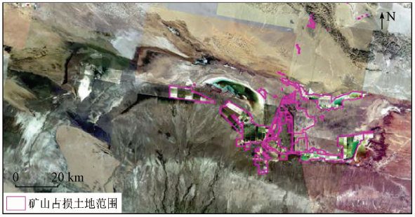
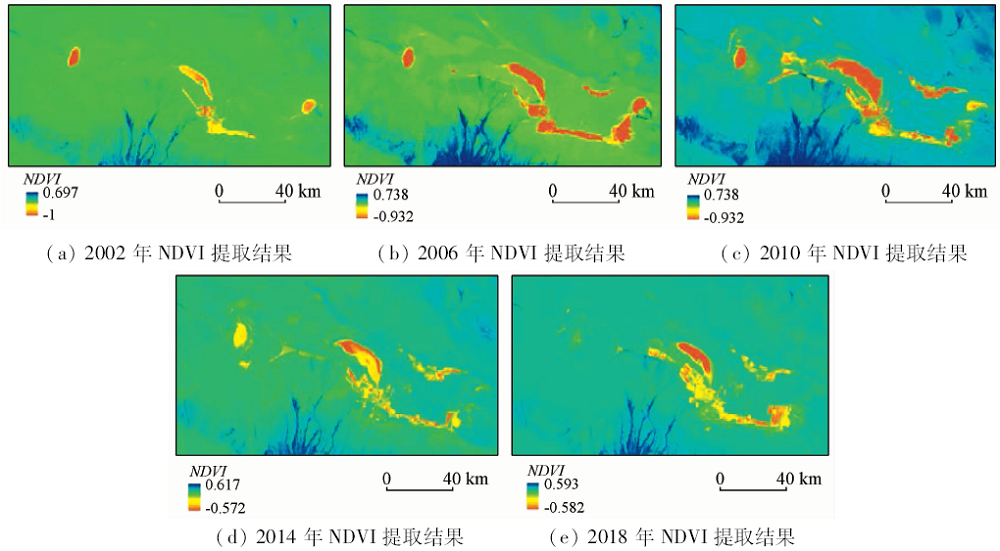
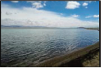
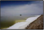
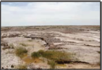
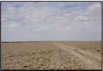
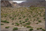
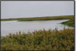
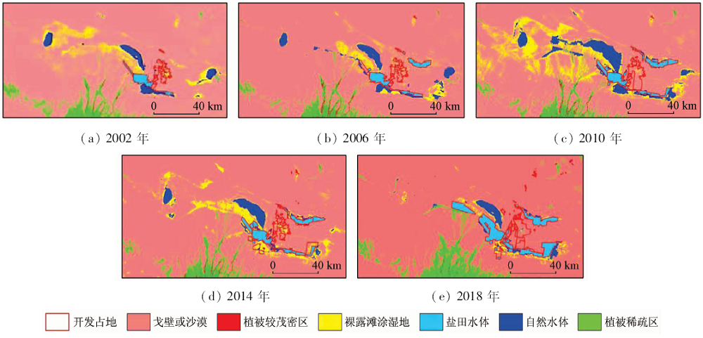
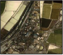
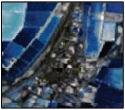
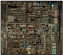
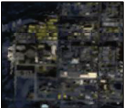
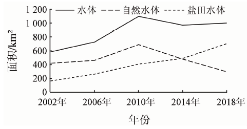
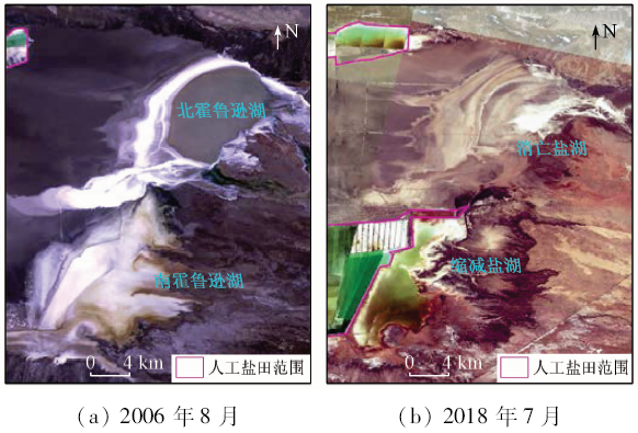
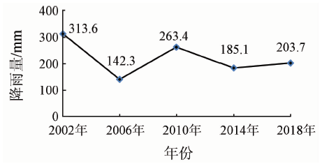
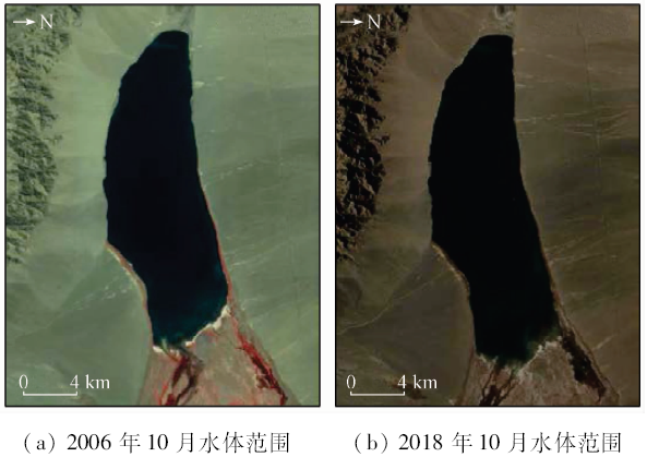
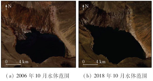
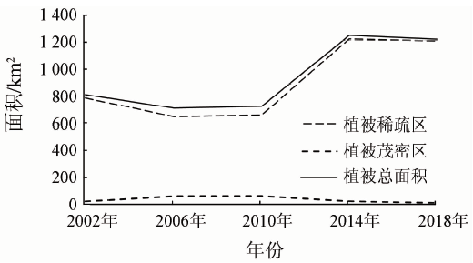
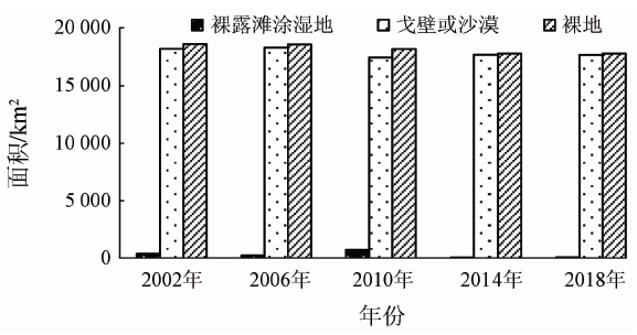
Abstract The Chaerhan Salt Lake contains abundant inorganic salts such as sodium chloride, potassium chloride and magnesium chloride, and it is also one of the mining bases in China. In recent years, with the rapid development of industrial mining activities in the Chaerhan Salt Lake and its surrounding salty field, the water quality of the salt lake has been polluted, and the lake water area has also rapidly decreased. By calculating the normalized vegetation index (NDVI) for the study area in 2002—2018, the authors obtained vegetation changes in the study area. Using remote sensing monitoring methods and combined with various factors such as rainfall and industrial development, the authors studied evolutionary trends and driving factors of the Chaerhan Salt Lake. Some conclusions have been reached: ① The development of salty field mine is the main factor causing the degradation of the Chaerhan Salt Lake. With the increase of the mining area of salt fields, the area of natural salt lakes has been greatly reduced, the amount of water has been reduced, and the salinization of water bodies has become serious. ② The area of the Chaerhan Salt Lake is affected by precipitation. In the years of abundant rainfall, the area of the salt lake has been larger, and smaller changes occur in the area of salt lakes in less rainy years. ③ Mining of salt fields will affect the growth of vegetation. According to the field investigation, salt field mining leads to serious salinization of salt lake water, and vegetation can hardly grow in the high salinity area, so there is less vegetation around the salt lake.
|
| Keywords
Chaerhan Salt Lake
NDVI
rainfall
mining
|
|
|
|
Issue Date: 14 March 2020
|
|
|
| [1] |
杨显华, 孙小飞, 黄洁 , 等. 青海木里煤矿区荒漠化的驱动因素及防治对策[J]. 中国地质灾害与防治学报, 2018,29(1):78-84.
|
| [1] |
Yang X H, Sun X F, Huang J , et al. Analysis of driving factors and prevention measures for desertification in muli coal mining area in Qinghai Province[J]. The Chinese Journal of Geological Hazard and Control, 2018,29(1):78-84.
|
| [2] |
王宏森 . 矿山开发过程中循环经济研究[J]. 现代冶金, 2009,37(2):9-10.
|
| [2] |
Wang H S . Research on circular economy in the process of mine development[J]. Modern Metallurgy, 2009,37(2):9-10.
|
| [3] |
赵玉灵 . 粤港澳大湾区自然资源遥感调查与保护建议[J]. 国土资源遥感, 2018,30(4):139-147.doi: 10.6046/gtzyyg.2017373.
|
| [3] |
Zhao Y L . Remote sensing survey and proposal for protection of the natural resources in Guangdong-Hong Kong-Macao Greater Bay Area[J]. Remote Sensing for Land and Resources, 2018,30(4):139-147.doi: 10.6046/gtzyyg.2017373.
|
| [4] |
陈丽新 . 国外矿山环境治理的思考[J]. 经济研究导刊, 2014(27):265-266.
|
| [4] |
Chen L X . Reflections on comprehensive ecological improvement of mines abroad[J]. Economic Research Guide, 2014(27):265-266.
|
| [5] |
杨显华, 黄洁, 田立 , 等. 矿山遥感监测在采空区稳定性分析中的应用[J]. 国土资源遥感, 2018,30(3):143-150.doi: 10.6046/gtzyyg.2018.03.20.
|
| [5] |
Yang X H, Huang J, Tian L , et al. Application of mine remote sensing monitoring to analysis of mine goaf stability[J]. Remote Sensing for Land and Resources, 2018,30(3):143-150.doi: 10.6046/gtzyyg.2018.03.20.
|
| [6] |
孟猛, 宗美娟 . 3S技术在矿山环境治理中的应用[J]. 中国矿业, 2011,20(9):59-61.
|
| [6] |
Meng M, Zong M J . The application of 3S technology in the treatments of mine environment[J]. China Mining Magazine, 2011,20(9):59-61.
|
| [7] |
岳媛媛, 苏敬勤 . 生态效率:国外的实践与我国的对策[J]. 科学研究, 2004,22(2):170-173.
|
| [7] |
Yue Y Y, Su J Q . Eco-efficiency:Foreign practice and our measure[J]. Studies in Science of Science, 2004,22(2):170-173.
|
| [8] |
赵振斌, 包浩生 . 国外城市自然保护与生态重建及其对我国的启示[J]. 自然资源学报, 2001,16(4):390-396.
|
| [8] |
Zhao Z B, Bao H S . Overseas urban nature conservation,ecological rehabilitation and enlightenments to China[J]. Journal of Natural Resources, 2001,16(4):390-396.
|
| [9] |
顾祝军, 曾志远, 史学正 , 等. 基于遥感图像不同辐射校正水平的植被覆盖度估算模型[J]. 应用生态学报, 2008,19(6):1296-1302.
|
| [9] |
Gu Z J, Zeng Z Y, Shi X Z , et al. Estimation models of vegetation fractional coverage (VFC) based on remote sensing image at different radiometric correction levels[J]. Chinese Journal of Applied Ecology, 2008,19(6):1296-1302.
|
| [10] |
黄敬峰, 王秀珍, 王人潮 , 等. 天然草地牧草产量与气象卫星植被指数的相关分析[J]. 农业现代化研究, 2000,21(1):33-36.
|
| [10] |
Huang J F, Wang X Z, Wang R C , et al. Relation analysis beween the production of natural grassland and satallite vegetation indices[J]. Research of Agricultural Modernization, 2000,21(1):33-36.
|
| [11] |
栾海军, 章欣欣, 田庆久 , 等. Landsat-7 ETM+归一化差分植被指数影像真实性检验[J]. 遥感信息, 2016,31(6):138-146.
|
| [11] |
Luan H J, Zhang X X, Tian Q J , et al. Validation of Landsat-7 ETM+NDVI imagery[J]. Remote Sensing Information, 2016,31(6):138-146.
|
| [12] |
杨金中, 秦绪文, 聂洪峰 , 等. 矿山遥感监测工作指南[M]. 北京: 中国大地出版社, 2009.
|
| [12] |
Yang J Z, Qin X W, Nie H F , et al. Mine Remote Sensing Monitoring Work Guide[M]. Beijing: China Land Press, 2009.
|
| [13] |
中国地质调查局. DD2011—06矿产资源开发遥感监测技术要求[S]. 北京:中国地质调查局, 2011.
|
| [13] |
China Geological Survey. DD2011—06 Technical Requirements for Remote Sensing Monitoring of Mineral Resources Development[S]. Beijing:China Geological Survey, 2011.
|
| [14] |
刘洪滨, 邵雪梅, 黄磊 , 等. 青海省海西州德令哈地区近千年来年降水量变化特征分析[J]. 第四纪研究, 2005,25(2):176-183.
|
| [14] |
Liu H B, Shao X M, Huang L , et al. Statistical characteristics of annual precipitation variation during the past 1 000 years in Delingha,Qinghai Province,China[J]. Quaternary Sciences, 2005,25(2):176-183.
|
| [15] |
李永顺 . 近35年德令哈市降水量日数的特征分析[J]. 青海气象, 2017(2):41-44.
|
| [15] |
Li Y S . Characteristic analysis of precipitation days in Delingha City in recent 35 years[J]. Qinghai Meteorology, 2017(2):41-44.
|
| [16] |
金爱兵, 孙金海, 吴顺川 . 露天矿深部开采边坡稳定性分析与治理方案研究[J]. 金属矿山, 2005(6):5-8.
|
| [16] |
Jin A B, Sun J H, Wu S C . Analysis of slope stability in deep mining of an open-pit mine and its control scheme[J]. Metal Mine, 2005(6):5-8.
|
| [17] |
宫成, 丁杨, 侯世占 . 矿山生态环境的恢复治理[J]. 煤炭技术, 2008,27(10):3-5.
|
| [17] |
Gong C, Ding Y, Hou S Z . Recovery and harnessing of the mine ecological environment[J]. Coal Technology, 2008,27(10):3-5.
|
| [18] |
关军洪, 郝培尧, 董丽 , 等. 矿山废弃地生态修复研究进展[J]. 生态科学, 2017,36(2):193-200.
|
| [18] |
Guan J H, Hao P Y, Dong L , et al. Review on ecological restoration of mine wasteland[J]. Ecological Science, 2017,36(2):193-200.
|
|
Viewed |
|
|
|
Full text
|
|
|
|
|
Abstract
|
|
|
|
|
Cited |
|
|
|
|
| |
Shared |
|
|
|
|
| |
Discussed |
|
|
|
|
 2020,
Vol. 32
2020,
Vol. 32