|
|
 |
|

|
|
|
Application of collaborative processing method to the analysis of remote sensing alteration abnormal causes: A case study of Fangshankou area in Beishan |
| Haihui HAN, Guangli REN, Yilin WANG, Min YANG, Anqiang YAO, Zhuan ZHANG |
| Key Laboratory for the Study of Focused Magmatism and Giant Ore Deposits, MNR, Xi’an Center of China Geological Survey/Northwest China Center for Geoscience Innovation, Xi’an 710054, China |
|
|
|
|
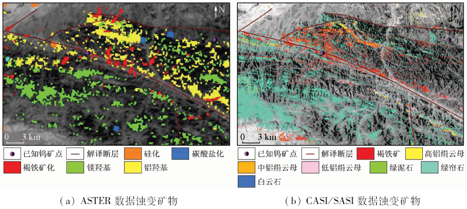
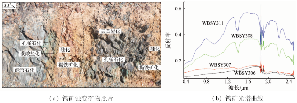
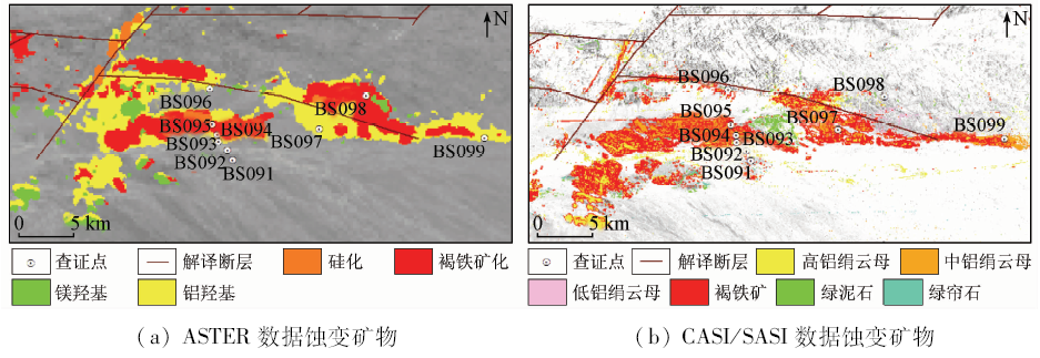
Abstract Remote sensing alteration anomaly is an important indicator of ore deposits. However, the previous studies of the geological genesis of remote sensing alteration anomaly and its indicative significance are insufficient and, as a result, the interpretation of remote sensing anomalies is often uncertain. In this paper, the authors established a multi-data source and multi-method collaborative processing method that can quantitatively explain the geological genesis and indication significance of remote sensing alteration anomaly. In this method, multi-spectral remote sensing is used to analyze the distribution characteristics of remote sensing alteration anomaly, hyperspectral remote sensing is used to decompose the remote sensing alteration anomaly information development pattern of typical geological bodies, and X-diffraction-rock identification-spectral solution is used to accurately identify altered mineral types. On the basis of the above experimental results, the geological genesis and indication significance are comprehensively explained. The test conducted in Fangshankou area of Beishan shows that the types of remote sensing alteration anomalies are basically consistent with the types of altered minerals developed on the surface, and the surrounding rock alterations of different ore-forming types of deposits can be effectively reflected by the specific altered mineral information combination. According to this regularity, lots of mineralization clues were discovered in this experiment, which realized the rapid transformation of remote sensing information into geological information. The study results show that this collaborative processing method would overcome the incompleteness of the analytical results of a single data source or a single method, and could improve the credibility of remote sensing alteration anomalies in geological applications.
|
| Keywords
collaborative processing
spectral analysis
X-diffraction
rock identification
remote sensing alteration anomaly
|
|
|
|
Issue Date: 14 March 2020
|
|
|
| [1] |
Van Der Meer F D, Van Der Werff H M A, Van Ruitenbeek F J A , et al. Multi-and hyperspectral geological remote sensing:A review[J]. International Journal of Applied Earth Observation and Geoformation, 2012,14(1):112-128.
|
| [2] |
Bishop C, Rivard B, De Souza Filho C , et al. Geological remote sensing[J]. International Journal of Applied Earth Observation and Geoinformation, 2018,64:267-274.
|
| [3] |
Asadzadeh S De Souza F C R . A review on spectral processing methods for geological remote sensing[J]. International Journal of Applied Earth Observation and Geoinformation, 2016,47:69-90.
|
| [4] |
Boissieu F F, Sevin B, Cudahy T . Regolith-geology mapping with support vector machine:A case study over weathered Ni-bearing peridotites,New Caledonia[J]. International Journal of Applied Earth Observation and Geoinformation, 2018,64:377-385.
|
| [5] |
Carrino T A, Crósta A P, Toledo C L B , et al. Hyperspectral remote sensing applied to mineral exploration in southern Peru:A multiple data integration approach in the Chapi Chiara gold prospect[J]. International Journal of Applied Earth Observation and Geoinformation, 2018,64:287-300.
|
| [6] |
汪子义, 张廷斌, 易桂花 , 等. Landsat8 OLI数据斑岩铜矿遥感蚀变矿物组合提取研究[J]. 国土资源遥感, 2018,30(3):89-95.doi: 10.6046/gtzyyg.2018.03.13.
|
| [6] |
Wang Z Y, Zhang T B, Yi G H , et al. Extraction of hydrothermal alteration mineral groups of porphyry copper deposits using Landsat8 OLI data[J]. Remote Sensing for Land and Resources, 2018,30(3):89-95.doi: 10.6046/gtzyyg.2018.03.13.
|
| [7] |
王瑞军, 闫柏琨, 李名松 , 等. 甘肃红山地区重要控矿地质单元GF-1数据遥感解译与应用[J]. 国土资源遥感, 2018,30(2):162-170.doi: 10.6046/gtzyyg.2018.02.22.
|
| [7] |
Wang R J, Yan B K, Li M S , et al. Remote sensing interpretation of important ore controlling geological units in Hongshan region of Gansu Province using GF-1 image and its application[J]. Remote Sensing for Land and Resources, 2018,30(2):162-170.doi: 10.6046/gtzyyg.2018.02.22.
|
| [8] |
范玉海, 王辉, 杨兴科 , 等. 基于高分辨率遥感数据的稀有金属矿化带勘查[J]. 国土资源遥感, 2018,30(1):128-134.doi: 10.6046/gtzyyg.2018.01.18.
|
| [8] |
Fan Y H, Wang H, Yang X K , et al. Application of high-resolution remote sensing technology to the prospecting for rare metal mineralization belt[J]. Remote Sensing for Land and Resources, 2018,30(1):128-134.doi: 10.6046/gtzyyg.2018.01.18.
|
| [9] |
江思宏 . 北山地区岩浆岩活动与金的成矿作用[D]. 北京:中国地质科学院, 2004.
|
| [9] |
Jiang S H . Magmatism and Gold Metallogeny in Beishan Mt.,Northwestern China[D]. Beijing:Chinese Academy of Geological Sciences, 2014.
|
| [10] |
杨合群, 李英, 杨建国 , 等. 北山造山带的基本成矿特征[J]. 西北地质, 2006,39(2):78-94.
|
| [10] |
Yang H Q, Li Y, Yang J G , et al. Main metallogenic characteristics in the Beishan orogen[J]. Northwestern Geology, 2006,39(2):78-94.
|
| [11] |
Kalinowski A, Oliver S . ASTER Mineral Index Processing Manual Compiled by Aleks Kalinowski[M]. Australia:Geoscience Australia, 2004: 36.
|
| [12] |
袁金国, 牛铮, 王锡平 . 基于FLAASH的Hyperion高光谱影像大气校正[J]. 光谱学与光谱分析, 2009,29(5):1181-1185.
|
| [12] |
Yang J G, Niu Z, Wang X P . Atmospheric correction of Hyperion hyperspectral image based on FLAASH[J]. Spectroscopy and Spectral Analysis, 2009,29(5):1181-1185.
|
| [13] |
叶发旺, 刘德长, 赵英俊 . CASI/SASI航空高光谱遥感测量系统及其在铀矿勘查中的初步应用[J]. 世界核地质科学, 2011,28(4):231-236.
|
| [13] |
Ye F W, Liu D C, Zhao Y J . Airborne hyper-spectral survey system CASI/SASI and its preliminary application in uranium exploration[J]. World Nuclear Geoscience, 2011,28(4):231-236.
|
| [14] |
韩海辉, 王艺霖, 任广利 , 等. 遥感蚀变异常非线性分析方法研究——以北山新、老金厂为例[J]. 国土资源遥感, 2017,29(1):43-49.doi: 10.6046/gtzyyg.2017.01.07.
|
| [14] |
Han H H, Wang Y L, Ren G L , et al. Nonlinear analysis method for remote sensing alteration anomalies:A case study of Xinjinchang and Laojinchang in Beishan[J]. Remote Sensing for Land and Resources, 2017,29(1):43-49.doi: 10.6046/gtzyyg.2017.01.07.
|
| [15] |
韩海辉, 王艺霖, 杨敏 , 等. 分维变点法在遥感蚀变异常提取中的应用[J]. 国土资源遥感, 2017,29(3):137-142.doi: 10.6046/gtzyyg.2017.03.20.
|
| [15] |
Han H H, Wang Y L, Yang M , et al. Application of fractal dimension-change point method to the extraction of remote sensing alteration anomaly[J]. Remote Sensing for Land and Resources, 2017,29(3):137-142.doi: 10.6046/gtzyyg.2017.03.20.
|
| [16] |
孙永君, 李大民 . 甘肃白峡尼山钨矿床成矿模式[J]. 甘肃科技, 2009,25(12):23-26.
|
| [16] |
Sun Y J, Li D M . Metallogenic model of the Baixianishan tungsten deposit in Gansu[J]. Gansu Science and Technology, 2009,25(12):23-26.
|
| [17] |
刘圣伟, 甘甫平, 闫柏琨 , 等. 成像光谱技术在典型蚀变矿物识别和填图中的应用[J]. 中国地质, 2006,33(1):178-186.
|
| [17] |
Liu S W, Gan F P, Yan B K , et al. Application of the imaging spectroscopic technique in mineral identification and mapping[J]. Geology in China, 2006,33(1):178-186.
|
|
Viewed |
|
|
|
Full text
|
|
|
|
|
Abstract
|
|
|
|
|
Cited |
|
|
|
|
| |
Shared |
|
|
|
|
| |
Discussed |
|
|
|
|
 2020,
Vol. 32
2020,
Vol. 32