|
|
 |
|

|
|
|
Spatio-temporal variation of land surface temperature and land cover responses in different seasons in Shengjin Lake wetland during 2000—2019 based on Google Earth Engine |
YE Wantong1( ), CHEN Yihong1, LU Yinhao1,2, Wu Penghai1,2,3() ), CHEN Yihong1, LU Yinhao1,2, Wu Penghai1,2,3() |
1. School of Resources and Environmental Engineering, Anhui University, Hefei 230601, China
2. Key Laboratory of Ecological Protection and Restoration of Wetland in Anhui Province, Anhui University, Hefei 230601, China
3. Institute of Physical Science and Information Technology, Anhui University, Hefei 230601, China |
|
|
|
|
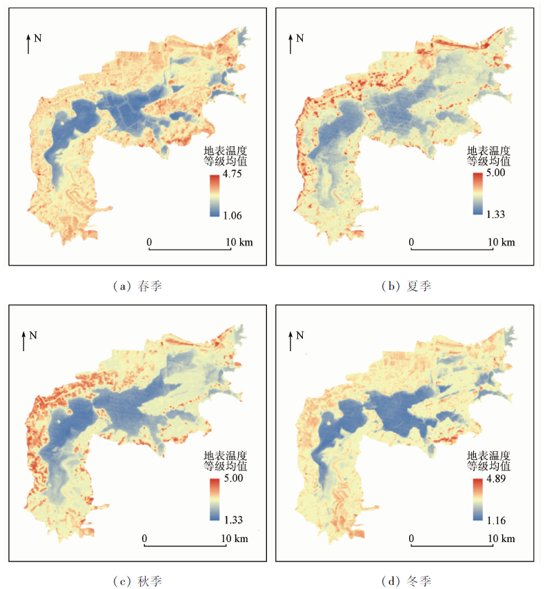
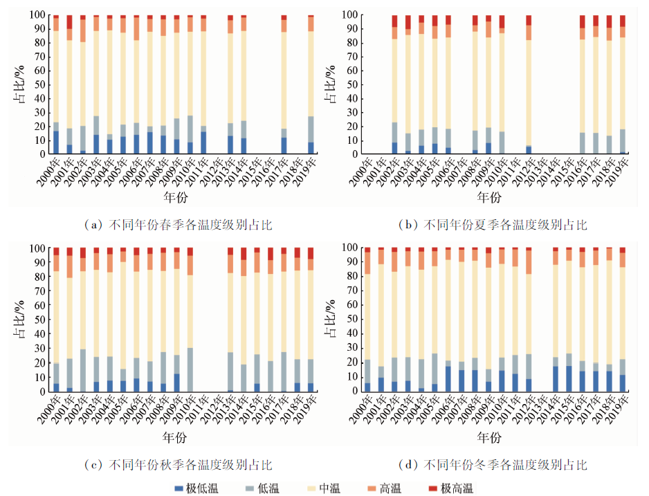
Abstract In order to better carry out the ecological protection and restoration of the wetland in the lower reaches of the Yangtze River, the authors selected the Landsat images of Shengjin Lake in different seasons from 2000 to 2019 as the research data with the support of Google Earth Engine (GEE) cloud platform. The land surface temperature (LST) was retrieved by a batch program using radiative transfer equation method. The spatio-temporal variation of LST and its responses to land cover in Shengjin Lake during the past 20 years were comprehensively analyzed. The results are as follows: ① From the perspective of space, the spatial distribution of different temperature grades has shown obvious differences with the seasonal changes. The high-temperature region is dispersed in spring, generally located in the northwest in summer and autumn, and mostly in the south in winter. The area of the lake varies with the seasons, but its temperature belongs to very low or low temperature grade at all seasons. ② From the perspective of time, in the past 20 years, affected by forest and water, the Shengjin Lake wetland has always been dominated by the medium and low temperature grades that account for a large proportion of 70%-85% or so. The area proportion of temperature grades varies with the time trend such as seasons and years. ③ There exist seasonal differences in the responses of LST to land cover. It is basically presented in the form of a descending order of artificial surface> cultivated land> forest and mudflat> water. ④ Non-urbanization factors have a certain impact on the surface temperature of natural wetland. The research results are certainly significant for the reasonable development of Shengjin Lake.
|
| Keywords
Google Earth Engine
Landsat
land surface temperature
spatio-temporal variation
Shengjin Lake
|
|
|
|
Corresponding Authors:
Wu Penghai
E-mail: gloria_998@163.com;wuph@ahu.edu.cn
|
|
Issue Date: 21 July 2021
|
|
|
| [1] |
杨永兴. 国际湿地科学研究的主要特点、进展与展望[J]. 地理科学进展, 2002(2):111-120.
|
| [1] |
Yang Y X. Main characteristics,progress and prospect of international wetland science research[J]. Progress in Geography, 2002(2):111-120.
|
| [2] |
孟宪民. 湿地与全球环境变化[J]. 地理科学, 1999(5):385-391.
|
| [2] |
Meng X M. Wetlands and global environmental change[J]. Scientia Geographica Sinica, 1999(5):385-391.
|
| [3] |
Turner S J. Landscape ecology concepts,methods and applications[J]. Landscape Ecology, 2005, 20(8):1031-1033.
doi: 10.1007/s10980-005-2076-7
url: http://link.springer.com/10.1007/s10980-005-2076-7
|
| [4] |
Larson D L. Effects of elimate on numbers of northern prairie wetlands[J]. Climate Change, 1995, 30:169-180.
doi: 10.1007/BF01091840
url: http://link.springer.com/10.1007/BF01091840
|
| [5] |
王艳慧, 肖瑶. 北京市1989—2010年地表温度时空分异特征分析[J]. 国土资源遥感, 2014, 26(3):146-152.doi: 10.6046/gtzyyg.2014.03.24.
doi: 10.6046/gtzyyg.2014.03.24
|
| [5] |
Wang Y H, Xiao Y. A temporal-spatial variation analysis of land surface temperature in Beijing[J]. Remote Sensing for Land and Resources, 2014, 26(3):146-152.doi: 10.6046/gtzyyg.2014.03.24.
doi: 10.6046/gtzyyg.2014.03.24
|
| [6] |
梁保平, 李晓宁. 城市LUCC时空格局对地表温度的影响效应研究——以广西柳州市为例[J]. 中国土地科学, 2016, 30(11):41-49,2.
|
| [6] |
Liang B P, Li X N. The effects of urban LUCC spatio-temporal structure on land surface temperatures:A case study in Liuzhou City[J]. China Land Sciences, 2016, 30(11):41-49,2.
|
| [7] |
Firozjaei M K, Kiavarz M, Alavipanah S K, et al. Monitoring and forecasting heat island intensity through multi-temporal image analysis and cellular automata-Markov chain modelling:A case of Babol City,Iran[J]. Ecological Indicators, 2018, 91:155-170.
doi: 10.1016/j.ecolind.2018.03.052
url: https://linkinghub.elsevier.com/retrieve/pii/S1470160X18302061
|
| [8] |
Chaudhuri G, Mishra N B. Spatio-temporal dynamics of land cover and land surface temperature in Ganges-Brahmaputra delta:A comparative analysis between India and Bangladesh[J]. Applied Geography, 2016, 68:68-83.
doi: 10.1016/j.apgeog.2016.01.002
url: https://linkinghub.elsevier.com/retrieve/pii/S0143622816300029
|
| [9] |
杜嘉, 张柏, 宋开山, 等. 基于Landsat-5 TM的洪河湿地地表温度估算方法对比研究[J]. 遥感技术与应用, 2009, 24(3):312-319,252.
|
| [9] |
Du J, Zhang B, Song K S, et al. A comparative study on estimated surface temperature based on Landsat-5 TM in the Honghe wetland[J]. Remote Sensing Technology and Application, 2009, 24(3):312-319,252.
|
| [10] |
邹骁, 李寅雷, 蒋景刚. 杭州市西溪湿地冬、夏季地表温度特征与地表类型关系分析[J]. 建设科技, 2013(2):76-80.
|
| [10] |
Zou X, Li Y L, Jiang J G. Analysis of the relationship between land surface temperature characteristics and land cover of Xixi wetland in winter and summer in Hangzhou[J]. Construction Science and Technology, 2013(2):76-80.
|
| [11] |
杜培军, 陈宇, 谭琨. 江苏滨海湿地土地利用/覆盖变化与地表温度响应遥感监测[J]. 国土资源遥感, 2014, 26(2):112-120.doi: 10.6046/gtzyyg.2014.02.19.
doi: 10.6046/gtzyyg.2014.02.19
|
| [11] |
Du P J, Chen Y, Tan K. The remote sensing monitoring of land use/cover change and land surface temperature responses over the coastal wetland in Jiangsu[J]. Remote Sensing for Land and Resources, 2014, 26(2):112-120.doi: 10.6046/gtzyyg.2014.02.19.
doi: 10.6046/gtzyyg.2014.02.19
|
| [12] |
郑慧祯, 陈燕红, 潘文斌, 等. 河口湿地表面温度扰动特征及其关键影响因素[J]. 生态学杂志, 2018, 37(8):2463-2473.
|
| [12] |
Zhen H Z, Chen Y H, Pan W B. Land surface temperature fluctuation characteristics and key influencing factors in estuarine wetland[J]. Chinese Journal of Ecology, 2018, 37(8):2463-2473.
|
| [13] |
李鑫, 董斌, 孙力, 等. 基于TM像元的湿地土地利用生态风险评价研究[J]. 水土保持研究, 2014, 21(4):114-118,321.
|
| [13] |
Li X, Dong B, Sun L, et al. Study on ecological risk assessment of Shengjing Lake wetland land use based on TM image pixels[J]. Research of Soil and Water Conservation, 2014, 21(4):114-118,321.
|
| [14] |
陈凌娜, 董斌, 彭文娟, 等. 升金湖自然湿地越冬鹤类生境适宜性变化研究[J]. 长江流域资源与环境, 2018, 27(3):556-563.
|
| [14] |
Chen L N, Dong B, Peng W J, et al. Study on the change of landscape pattern on habitat environment of winter cranes in Shengjin Lake nature wetland[J]. Resources and Environment in the Yangtze Basin, 2018, 27(3):556-563.
|
| [15] |
宋昀微, 周立志. 生境变化对升金湖越冬水鸟群落时空动态的影响[J]. 安徽农业大学学报, 2019, 46(4):610-617.
|
| [15] |
Song Y W, Zhou L Z. Effects of habitat changes on spatio-temporal pattern of the wintering waterbrid community at Shengjin Lake[J]. Journal of Anhui Agricultural University, 2019, 46(4):610-617.
|
| [16] |
陈广洲, 葛欢, 施金菊, 等. 4个时期升金湖湿地的土地利用动态研究[J]. 湿地科学, 2017, 15(1):20-24.
|
| [16] |
Chen G Z, Ge H, Shi J J, et al. Dynamic of land use of Shengjin Lake wetlands in four periods[J]. Wetland Science, 2017, 15(1):20-24.
|
| [17] |
张双双, 董斌, 杨斐, 等. 升金湖湿地景观格局变化对越冬鹤类地理分布的影响[J]. 长江流域资源与环境, 2019, 28(10):2461-2470.
|
| [17] |
Zhang S S, Dong B, Yang F, et al. Influence of landscape pattern change of Shengjin Lake wetland on the geographical distribution of overwintering cranes[J]. Resources and Environment in the Yangtze Basin, 2019, 28(10):2461-2470.
|
| [18] |
高燕, 梁泽毓, 王彪, 等. 基于无人机和卫星遥感影像的升金湖草滩植被地上生物量反演[J]. 湖泊科学, 2019, 31(2):517-528.
|
| [18] |
Gao Y, Liang Z Y, Wang B, et al. UAV and satellite remote sensing images based aboveground biomass inversion in the meadows of Lake Shengjin[J]. Journal of Lake Sciences, 2019, 31(2):517-528.
|
| [19] |
王行行, 王杰, 崔玉环. 基于Sentinel-2 MSI影像的河湖系统水体悬浮物空间分异遥感监测:以安徽省升金湖与连接长江段为例[J]. 环境科学, 2020, 41(3):1207-1216.
|
| [19] |
Wang H H, Wang J, Cui Y H. Remote sensing monitoring on spatial differentiation of suspended sediment concentration in a river-lake system based on Sentinel-2 MSI imaging:A case for Shengjin Lake and connected Yangtze River section in Anhui Province[J]. Environmental Science, 2020, 41(3):1207-1216.
|
| [20] |
Pereira O J R, Merino E R, Montes C R, et al. Estimating water pH using cloud-based Landsat images for a new classification of the Nhecolândia lakes (Brazilian Pantanal)[J]. Remote Sensing, 2020, 12(7):1090.
doi: 10.3390/rs12071090
url: https://www.mdpi.com/2072-4292/12/7/1090
|
| [21] |
Adeola F O, Gbenga A E, Oludapo O A, et al. Land use/land cover change and land surface temperature of Ibadan and environs,Nigeria[J]. Environmental Monitoring and Assessment, 2020, 192(2):109.
doi: 10.1007/s10661-019-8054-3
url: https://doi.org/10.1007/s10661-019-8054-3
|
| [22] |
Sengupta D, Chen R S, Meadows M E, et al. Mapping trajectories of coastal land reclamation in nine deltaic megacities using Google Earth Engine[J]. Remote Sensing, 2019, 11(22):2621.
doi: 10.3390/rs11222621
url: https://www.mdpi.com/2072-4292/11/22/2621
|
| [23] |
宋金春. 安徽升金湖国家级自然保护区湿地保护与恢复建设方案初探[J]. 华东森林经理, 2008(1):61-64.
|
| [23] |
Song J C. Preliminary discussion on wetland protection and restoration plan of Shengjin Lake national nature reserve in Anhui province[J]. East China Forest Management, 2008(1):61-64.
|
| [24] |
徐晗泽宇, 刘冲, 王军邦, 等. Google Earth Engine平台支持下的赣南柑橘果园遥感提取研究[J]. 地球信息科学学报, 2018, 20(3):396-404.
doi: 10.12082/dqxxkx.2018.170553
|
| [24] |
Xu H Z Y, Liu C, Wang J B, et al. Study on extraction of citrus orchard in Gannan region based on Google Earth Engine platform[J]. Journal of Geo-Information Science, 2018, 20(3):396-404.
|
| [25] |
朱娴飞, 陆雨婷, 吴鹏海, 等. 近30年长江下游升金湖湿地不同季节景观生态风险时空分析[J]. 湖泊科学, 2020, 32(3):813-825.
|
| [25] |
Zhu X F, Lu Y T, Wu P H, et al. Spatial-temporal analysis of landscape ecological risk in different seasons during the past 30 years in Lake Shengjin wetland,lower reaches of the Yangtze River[J]. Journal of Lake Sciences, 2020, 32(3):813-825.
|
| [26] |
赵国辉, 张耀南, 康建芳. 中巴经济走廊2013—2018年地表温度高分辨率反演数据集[J/OL]. 中国科学数据, 2018.( 2018- 10- 22). http://www.cnki.com.cn/Article/CJFDTotal-KXGZ201903007.htm
url: http://www.cnki.com.cn/Article/CJFDTotal-KXGZ201903007.htm
|
| [26] |
Zhao G H, Zhang Y N, Kang J F. A dataset of high-resolution land surface temperature inversion for the China-Pakistan Economic Corridor(2013-2018)[J/OL]. China Scientific Data, 2018.( 2018- 10- 22). http://www.cnki.com.cn/Article/CJFDTotal-KXGZ201903007.htm
url: http://www.cnki.com.cn/Article/CJFDTotal-KXGZ201903007.htm
|
| [27] |
Duan S B, Li Z L, Li H, et al. Validation of Collection 6 MODIS land surface temperature product using in situ measurements[J]. Remote Sensing of Environment, 2019, 225:16-29.
doi: 10.1016/j.rse.2019.02.020
url: https://linkinghub.elsevier.com/retrieve/pii/S0034425719300756
|
| [28] |
Sekertekin A, Bonafoni S. Land surface temperature retrieval from Landsat 5,7,and 8 over rural areas:Assessment of different retrieval algorithms and emissivity models and toolbox implementation[J]. Remote Sensing, 2020, 12(2):294.
doi: 10.3390/rs12020294
url: https://www.mdpi.com/2072-4292/12/2/294
|
| [29] |
徐涵秋. 新型Landsat8卫星影像的反射率和地表温度反演[J]. 地球物理学报, 2015, 58(3):741-747.
|
| [29] |
Xu H Q. Retrieval of the reflectance and land surface temperature of the newly-launched Landsat 8 satellite[J]. Chinese Journal of Geophysics, 2015, 58(3):741-747.
|
| [30] |
白洁, 刘绍民, 扈光. 针对TM/ETM+遥感数据的地表温度反演与验证[J]. 农业工程学报, 2008(9):148-154,2.
|
| [30] |
Bai J, Liu S M, Hu G. Inversion and verification of land surface temperature with remote sensing TM/ETM+ data[J]. Transactions of the Chinese Society of Agricultural Engineering, 2008(9):148-154,2.
|
| [31] |
史新, 周买春, 刘振华, 等. 基于Landsat 8数据的3种地表温度反演算法在三河坝流域的对比分析[J]. 遥感技术与应用, 2018, 33(3):465-475.
|
| [31] |
Shi X, Zhou M C, Liu Z H, et al. Comparative analysis on three land surface temperature inversion algorithm based on Landsat 8 data over Sanheba basin[J]. Remote Sensing Technology and Application, 2018, 33(3):465-475.
|
| [32] |
Ottle C, Stoll M. Effect of atmospheric absorption and surface emissivity on the determination of land surface temperature from infrared satellite data[J]. International Journal of Remote Sensing, 1993, 14(10):2025-2037.
doi: 10.1080/01431169308954018
url: https://www.tandfonline.com/doi/full/10.1080/01431169308954018
|
| [33] |
Barsi J A, Schott J R, Palluconi F D, et al. Validation of a web-based atmospheric correction tool for single thermal band instruments[J]. Proceedings of Spie the International Society for Optical Engineering, 2005, 5882.
|
| [34] |
乔治, 田光进. 北京市热环境时空分异与区划[J]. 遥感学报, 2014, 18(3):715-734.
|
| [34] |
Qiao Z, Tian G J. Spatiotemporal diversity and regionalization of the urban thermal environment in Beijing[J]. Journal of Remote Sensing, 2014, 18(3):715-734.
|
| [35] |
康晓明, 崔丽娟, 赵欣胜, 等. 北京市湿地缓解热岛效应功能分析[J]. 中国农学通报, 2015, 31(22):199-205.
|
| [35] |
Kang X M, Cui L J, Zhao X S, et al. Analysis of alleviation of urban heat island effect by wetlands in Beijing[J]. Chinese Agricultural Science Bulletin, 2015, 31(22):199-205.
|
|
Viewed |
|
|
|
Full text
|
|
|
|
|
Abstract
|
|
|
|
|
Cited |
|
|
|
|
| |
Shared |
|
|
|
|
| |
Discussed |
|
|
|
|
 2021,
Vol. 33
2021,
Vol. 33