|
|
 |
|

|
|
|
A study of mine site selection of the Duolong ore concentration area in Tibet based on RS and GIS technology |
ZHAO Longxian1( ), DAI Jingjing2(), ZHAO Yuanyi2, JIANG Qi3, LIU Tingyue3, FU Minghai1 ), DAI Jingjing2(), ZHAO Yuanyi2, JIANG Qi3, LIU Tingyue3, FU Minghai1 |
1. China University of Geosciences (Beijing) Chinese Academy of Geological Science,Beijing 100083, China
2. Institute of Mineral Resources, Chinese Academy of Geological Science, Beijing 100037, China
3. School of Earth Sciences and Resources, China University of Geosciences (Beijing), Beijing 100083, China |
|
|
|
|
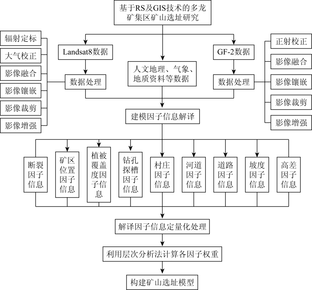
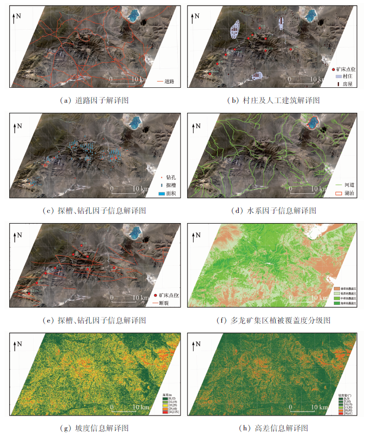
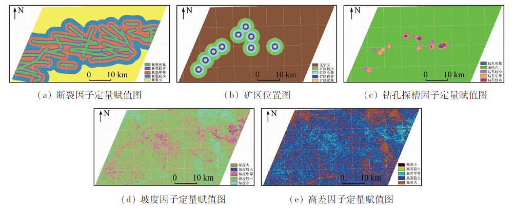
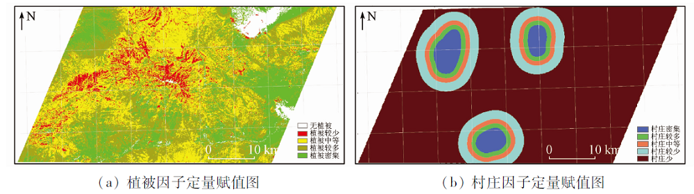
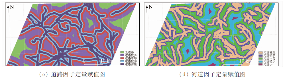
Abstract Mineral resources are an important part of natural resources and constitute an important material basis for the development of human society. With the rapid development of economic construction, the demand for mineral resources has become increasingly urgent, and the ecological environment destruction caused by mineral development has also become increasingly prominent. The construction of green mines and green development is the inevitable trend of mine development. In the construction of green mines, the site selection of mines is particularly important. With the Duolong ore concentration area as the study area and through the good grades ii and Landsat8 remote sensing satellite image preprocessing, the authors extracted information of a series of important environmental factors such as fault location, vegetation coverage, drilling and mining area and exploratory trench, village, river, road, slope and elevation difference for quantitative interpretation and normalized processing; finally the analytic hierarchy process (AHP) was used to calculate weight coefficient of each factor and construct the green mining location model in the study area. Specific layout planning was carried out for the mining stopes, waste rock sites, administrative living areas, mineral processing plants and tailings ponds of some mineral deposits in the Duolong ore concentration area of Tibet so as to provide basic data and reference suggestions for the development and construction of green mines.
|
| Keywords
Duolong ore concentration area
RS
GIS
analytic hierarchy process
mine location
|
|
|
|
Corresponding Authors:
DAI Jingjing
E-mail: 2428426555@qq.com;daijingjing863@sina.com
|
|
Issue Date: 21 July 2021
|
|
|
| [1] |
中国矿业联合会. 固体矿产绿色矿山建设指南(试行):T/CMAS 0001—2017[S]. 2017.
|
| [1] |
China Mining Association. ide for the construction of solid mineral Green Mines(for Trial Implementation):T/CMAS 0001—2017[S]. 2017.
|
| [2] |
Wagner T. Tunnel-site selection by remote sensing techniques[J]. Electromagnetism, 1972.
|
| [3] |
Kundu B S, Manchanda M L. Role of remote sensing in residential site selection:A case study of Hisar Town and its environs[J]. Journal of the Indian Society of Remote Sensing, 1994, 22(4):203-214.
doi: 10.1007/BF03026520
url: http://link.springer.com/10.1007/BF03026520
|
| [4] |
陈昌礼. 遥感和物探在核电站选址中的应用[J]. 物探与化探, 1985, 9(2):86-91.
|
| [4] |
Cheng C L. The application of remote sensing and geophysical prospecting to the choice of site for thenu clear power station[J]. Geophysical & Geochemical Exploration, 1985, 9(2):86-91.
|
| [5] |
Jagadeesha C J, Adiga S. Some aspects of selection of small hydro project sites using remote sensing and GIS[C]// 1st International Conference on Renewable Energy-Small Hydro. 1997.
|
| [6] |
蔡爱民. GIS在城市生活垃圾卫生填埋点选址中的应用研究——以芜湖市为例[D]. 芜湖:安徽师范大学, 2003.
|
| [6] |
Cai A M. Application research with GIS on site selecting of land fill of city life waste—A case study on Wuhu City[D]. Wuhu:Anhui Normal University, 2003.
|
| [7] |
李淑贞, 姚玲, 刘纬. GIS在城市生活垃圾卫生填埋场选址中的应用[J]. 地理空间信息, 2006(3):35-37.
|
| [7] |
Li S Z, Yao L, Liu W. Application of GIS to the Siting of City Refuse Landfill[J]. Geospatial Information, 2006(3):35-37.
|
| [8] |
陈寰, 毛楠. 基于GIS的生活垃圾填埋场选址的应用研究[J]. 环境工程, 2013(s1):513-516.
|
| [8] |
Chen H, Mao N.application of gis to site selection of municipal solid waste landfill[J]. Environmental Engineering, 2013(s1):513-516.
|
| [9] |
曾远文, 丁忆, 胡艳, 等. 农村居民点空间布局及优化分析——以重庆市合川区狮滩镇聂家村为例[J]. 国土资源遥感, 2018, 30(3):113-119.doi: 10.6046/gtzyyg.2018.03.16.
doi: 10.6046/gtzyyg.2018.03.16
|
| [9] |
Zeng Y W, Yi D, HU Y, et al. An analysis of spatial distribution and optimization of rural settlements:A case study of Niejia Village in Shitan Town,Hechuan District,Chongqing[J]. Remote Sensing for Land and Resources, 2018, 30(3):113-119.doi: 10.6046/gtzyyg.2018.03.16.
doi: 10.6046/gtzyyg.2018.03.16
|
| [10] |
李天华, 廖崇高, 杨武年, 等. 多类型遥感影像在高原机场选址中的应用初探[J]. 地质找矿论丛, 2006(3):220-223.
|
| [10] |
Li T H, Liao C G, Yang W N, et al. Application of multi-type remote sensing image in site selection of Plateau airport[J]. Discussion Series on Geological Prospecting, 2006(3):220-22
|
| [11] |
张瑞军. 遥感图像三维可视化在康定机场建设中的应用[D]. 成都:成都理工大学, 2006.
|
| [11] |
Zhang R J. Application of 3-d visualization of remote sensing image in the construction of Dartsendo airport[D]. Chengdu:Chengdu University of Technology, 2006.
|
| [12] |
郭俊, 牛铮. 遥感图像三维可视化在机场选址中的应用[J]. 工程地质计算机应用, 2007, 45(1):5-6.
|
| [12] |
Guo J, Niu Z. Application of 3-d visualization of remote sensing image in airport site selection[J]. Computer Applications in Engineering Geology, 2007, 45(1):5-6.
|
| [13] |
万里红. “3S”技术在西藏阿里机场工程地质勘察中的应用研究[D]. 成都:成都理工大学, 2007.
|
| [13] |
Wan L H. Application of “3 s” technology in engineering geological investigation of Ali Airport in Tibet[D]. Chengdu:Chengdu University of Technology, 2007.
|
| [14] |
杨金中. 遥感技术在工程地质选址工作中的应用[J]. 国土资源遥感, 2007, 19(4):90-94.doi: 10.6046/gtzyyg.2007.04.20.
doi: 10.6046/gtzyyg.2007.04.20
|
| [14] |
Yand J Z. The aplication of remote sensing to engineering geological site selection[J]. Remote Sensing for Land and Resources, 2007, 19(4):90-94.doi: 10.6046/gtzyyg.2007.04.20.
doi: 10.6046/gtzyyg.2007.04.20
|
| [15] |
戴晓爱, 杨武年, 刘汉湖, 等. 遥感图像三维可视化及在腾冲机场建设中的应用研究[J]. 遥感信息, 2008(2):60-63.
|
| [15] |
Dai X A, Yang W N, Liu H H, et al. 3d visualization of remote sensing images and its application in the construction of Tengchong City Airport[J]. Remote Sensing Information, 2008(2):60-63.
|
| [16] |
李天华, 杨武年. 遥感与GIS技术支持下的机场选址与工程地质分析[J]. 物探化探计算技术, 2011, 33(1):79-83.
|
| [16] |
Li T H, Yang W N. Airport site selection and engineering geological analysis based on RS and GIS Technology[J]. Geophysical and Geochemical Computing Technology, 2011, 331:79-83.
|
| [17] |
方洪宾, 赵福岳, 路云阁, 等. 青藏高原生态地质环境遥感调查研究[J]. 国土资源遥感, 2007, 19(4):61-65.doi: 10.6046/gtzyyg.2007.04.14.
doi: 10.6046/gtzyyg.2007.04.14
|
| [17] |
Fang H B, Zhao F Y, Lu Y G, et al. Investigation of eco-geological environment in Qinghai-Tibet Plateau by remote sensing[J]. Remote Sensing of Land and Resources, 2007, 19(4):61-65.doi: 10.6046/gtzyyg.2007.04.14.
doi: 10.6046/gtzyyg.2007.04.14
|
| [18] |
代晶晶, 王瑞江, 王润生, 等. 基于蚀变信息提取的西藏班公湖—怒江成矿带中段斑岩铜矿找矿预测[J]. 地球学报, 2012, 33(5):755-762.
|
| [18] |
Dai J J, Wang R J, Wang R S, et al. Prediction of porphyry copper deposits in the middle part of Bangonghu-Salween River metallogenic belt,Tibet,based on alteration information[J]. Journal of Earth Sciences, 2012, 335:755-762.
|
| [19] |
唐菊兴, 孙兴国, 丁帅, 等. 西藏多龙矿集区发现浅成低温热液型铜(金银)矿床[J]. 地球学报, 2014, 35(1):6-10.
|
| [19] |
Tang J X, Sun X G, Ding S, et al. Epithermal Cu-Au-Ag deposit discovered in the duolong ore concentration area,Tibet[J]. Journal of Earth Sciences, 2014, 35(1):6-10.
|
| [20] |
宁墨奂, 胡昌松, 温春齐, 等. 西藏班-怒成矿带多龙矿集区斑岩铜矿综合信息找矿预测[J]. 金属矿产, 2013, 49(1):58-66.
|
| [20] |
Ning M H, Hu C S, Wen C Q, et al. Metallogenic prognosis based on comprehensive information in the Duolong ore concentration area of the Bangonghu-Nujiang metallogenic belt,Tibet[J]. Geology and Exploration, 2013, 49(1):58-66.
|
| [21] |
刘雷震, 姚佛军, 武建军, 等. 多源数据在西藏多龙矿集区找矿实践中的应用[J]. 北京师范大学学报(自然科学版), 2016, 52(2):184-188.
|
| [21] |
Liu L Z, Yao F J, Wu J J, et al. Application of multi-source data to prospecting practice in the duolong ore concentration area of Tibet[J]. Journal of Beijing Normal University, 2016, 52(2):184-188.
|
| [22] |
孙振明. 西藏班—怒成矿带西段多龙矿集区铜金成矿作用与成矿规律[D]. 长春:吉林大学, 2015.
|
| [22] |
Sun Z M. Copper-gold mineralization and metallogenic regularity of duolong ore concentration area in the western part of Banfo NU metallogenic belt,Tibet[D]. Changchun:Jilin University, 2015.
|
| [23] |
祝向平, 陈华安, 马东方, 等. 西藏多不杂斑岩铜金矿床地质与蚀变[J]. 地质与勘探, 2012, 48(2):199-206.
|
| [23] |
Zhu X P, Chen H A, Ma D F, et al. Dobuza porphyry copper-gold Deposit,Tibet[J]. Geology and Exploration, 2012, 482(2):199-206.
|
| [24] |
Defries R, Townshend J. NDVI-derived land cover classification at global scales[J]. International Journal of Remote Sensing, 1994, 15(17):3567-3586.
doi: 10.1080/01431169408954345
url: https://www.tandfonline.com/doi/full/10.1080/01431169408954345
|
|
Viewed |
|
|
|
Full text
|
|
|
|
|
Abstract
|
|
|
|
|
Cited |
|
|
|
|
| |
Shared |
|
|
|
|
| |
Discussed |
|
|
|
|
 2021,
Vol. 33
2021,
Vol. 33