|
|
 |
|

|
|
|
Detection of active landslides in central Maoxian County using Sentinel-1 and ALOS-2 data |
ZHANG Teng1( ), XIE Shuai2, HUANG Bo3, FAN Jinghui4(), CHEN Jianping1, TONG Liqiang4 ), XIE Shuai2, HUANG Bo3, FAN Jinghui4(), CHEN Jianping1, TONG Liqiang4 |
1. School of Earth Sciences and Resources, China University of Geosciences, Beijing 100083, China
2. Beijing Municipal Commission of Transport, Beijing 100073, China
3. Hebei Hydrological Engineering Geological Exploration Institute, Shijiazhuang 050021, China
4. China Aero Geophysical Survey and Remote Sensing Centre for Natural Resources, Beijing 100083, China |
|
|
|
|
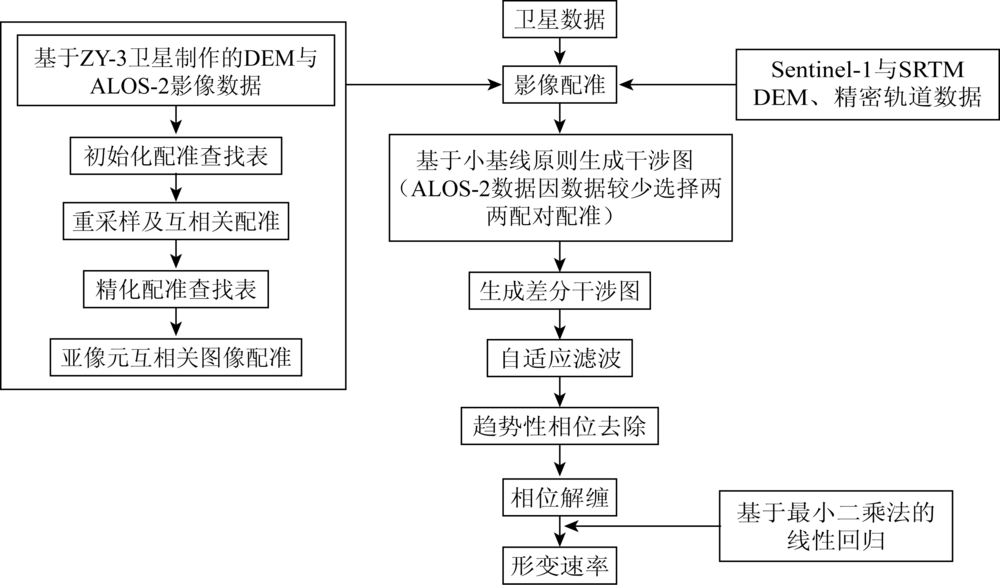
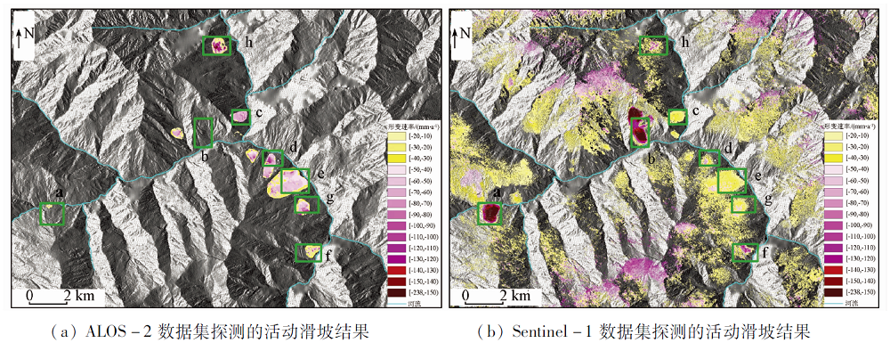
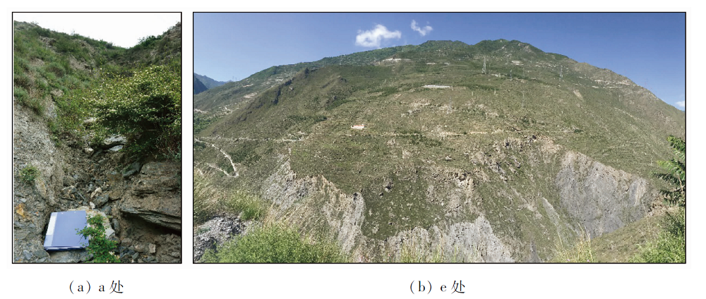
Abstract Based on satellite images of two different wavelengths acquired by ALOS-2 and Sentinel-1, the authors used DInSAR two-track method and stacking technology to analyze and delineate the active landslide that is undergoing surface deformation in the central part of Maoxian County, Sichuan Province. First, in view of the long time baseline of the ALOS-2 satellite and the small amount of image data, the two-track DInSAR method was used to detect landslide deformation. Secondly, on the basis of the short-time baseline multi-scene Sentinel-1 data, the stacking technology was used to detect landslide deformation. Finally, comprehensive analysis of the deformation rate results of the two data sets was conducted, and the potential landslide area in the middle of Maoxian County of Sichuan was delineated. The results show that the suspected active landslides in Baibu Village of Maoxian County and other places have obvious surface deformation, and the maximum absolute amount of radar line-of-sight deformation rate reaches 200 mm/a; combined with optical image characteristics and existing historical survey data, 8 active landslides were delineated, and the exploration result of two kinds of data shows that the detection results of the data can correspond to each other in the spatial distribution of 7 active landslides. Field surveys were conducted on 6 active landslides, and signs of ground deformation were found. The work in this paper shows that using a small number of long-band ALOS-2 images and the DInSAR two-track method can detect more obvious landslide surface deformation in mountainous areas with certain vegetation coverage; when C-band Sentinel-1 images are applied, accumulation of continuous multi-scene data is required; in addition, by applying time series analysis method, the detection effect is better than the two-track method using ALOS-2 images.
|
| Keywords
Maoxian County landslides
DInSAR
Stacking
ALOS-2
Sentinel-1
|
|
|
|
Corresponding Authors:
FAN Jinghui
E-mail: 1345872622@qq.com;jhfan2004@qq.com
|
|
Issue Date: 21 July 2021
|
|
|
| [1] |
邵崇建, 李芃宇, 李勇, 等. 茂县滑坡的滑动机制与震后滑坡形成的地质条件[J]. 成都理工大学学报(自然科学版), 2017, 44(4):385-402.
|
| [1] |
Shao C J, Li F Y, Li Y, et al. Sliding mechanism of Maoxian landslide and geological condition analysis of formation of post-earthquake landslide[J]. Journal of Chengdu University of Technology(Science & Technology Edition), 2017, 44(4):385-402.
|
| [2] |
范景辉. 三峡库区范家坪滑坡地表形变InSAR监测与综合分析[J]. 地质通报, 2017, 36(9):1665-1673.
|
| [2] |
Fan J H. InSAR monitoring and synthetic analysis of the surface deformation of Fanjiaping landslide in the Three Gorges Reservoir area[J]. Geological Bulletin of China, 2017, 36(9):1665-1673.
|
| [3] |
Liu G, Guo H, Perski Z, et al. Landslide movement monitoring with ALOS-2 SAR data[J]. IOP Conference Series Earth and Environmental Science, 2019, 227:062015.
doi: 10.1088/1755-1315/227/6/062015
url: https://iopscience.iop.org/article/10.1088/1755-1315/227/6/062015
|
| [4] |
王振林, 廖明生, 张路, 等. 基于时序Sentinel-1数据的锦屏水电站左岸边坡形变探测与特征分析[J]. 国土资源遥感, 2019, 31(2):204-209.doi: 10.6046/gtzyyg.2019.02.28.
doi: 10.6046/gtzyyg.2019.02.28
|
| [4] |
Wang Z L, Liao M S, Zhang L, et al. Detecting and characterizing deformations of the left bank slope near the Jinping hydropower station with time series Sentinel-1 data[J]. Remote Sensing for Land and Resources, 2019, 31(2):204-209.doi: 10.6046/gtzyyg.2019.02.28.
doi: 10.6046/gtzyyg.2019.02.28
|
| [5] |
Intrieri E, Raspini F, Fumagalli A, et al. The Maoxian landslide as seen from space:Detecting precursors of failure with Sentinel-1 data[J]. Landslides, 2017, 15(3):1-10.
|
| [6] |
高思远, 黄诗峰, 孙亚勇, 等. Sentinel-1 SAR数据在四川茂县山体滑坡灾害监测中的应用研究[J]. 中国水利水电科学研究院学报, 2019, 17(2):132-138.
|
| [6] |
Gao S Y, Huang S F, Sun Y Y, et al. Research on the application of Sentinel-1 SAR data in monitoring of landslide disaster in Maoxian County Sichuan[J]. Journal of China Institute of Water Resources and Hydropower Research, 2019, 17(2):132-138.
|
| [7] |
许强, 李为乐, 董秀军, 等. 四川茂县叠溪镇新磨村滑坡特征与成因机制初步研究[J]. 岩石力学与工程学报, 2017, 36(11):2612-2628.
|
| [7] |
Xu Q, Li W L, Dong X J, et al. The Xinmocun landslide on June 24,2017 in Maoxian,Sichuan:Characteristics and failure mechanism[J]. Chinese Journal of Rock Mechanics and Engineering, 2017, 36(11):2612-2628.
|
| [8] |
温铭生, 陈红旗, 张鸣之, 等. 四川茂县“6·24”特大滑坡特征与成因机制分析[J]. 中国地质灾害与防治学报, 2017, 28(3):1-7.
|
| [8] |
Wen M S, Chen H Q, Zhang M Z, et al. Characteristics and formation mechanism analysis of the “6·24” catastrophic landslide of the June 24 of 2017,at Maoxian,Sichuan[J]. The Chinese Journal of Geological Hazard and Control, 2017, 28(3):1-7.
|
| [9] |
Liang C, Liu Z, Fielding E J, et al. InSAR time series analysis of L-band wide-swath SAR data acquired by ALOS-2[J]. IEEE Transactions on Geoscience and Remote Sensing, 2018, 56(8):4492-4506.
doi: 10.1109/TGRS.2018.2821150
url: https://ieeexplore.ieee.org/document/8353781/
|
| [10] |
Dong Y, Chen W, Chang H, et al. Assessment of orthoimage and DEM derived from ZY-3 stereo image in Northeastern China[J]. Survey Review, 2016, 48(349):247-257.
doi: 10.1179/1752270615Y.0000000027
url: https://www.tandfonline.com/doi/full/10.1179/1752270615Y.0000000027
|
| [11] |
李健强, 韩海辉, 高婷, 等. 资源三号卫星在地质灾害调查评价中的应用——以宝鸡黄土区为例[J]. 国土资源遥感, 2017, 29(s1):73-80.doi: 10.6046/gtzyyg.2017.s1.12.
doi: 10.6046/gtzyyg.2017.s1.12
|
| [11] |
Li J Q, Han H H, Gao T, et al. The application of ZY-3 satellite to geological hazards survey and evaluation:A case study of Baoji loess area[J]. Remote Sensing For Land and Resources, 2017, 29(s1):73-80.doi: 10.6046/gtzyyg.2017.s1.12.
doi: 10.6046/gtzyyg.2017.s1.12
|
| [12] |
张晓博, 赵学胜, 葛大庆, 等. 基于Sentinel TOPS模式Stacking技术监测淮南矿区沉降[J]. 国土资源遥感, 2018, 30(4):200-205.doi: 10.6046/gtzyyg.2018.04.30.
doi: 10.6046/gtzyyg.2018.04.30
|
| [12] |
Zhang X B, Zhao X S, Ge D Q, et al. Subsidence monitoring of Huainan coal mine from Sentinel TOPS images based on Stacking technique[J]Remote Sensing for Land and Resources, 2018, 30(4):200-205.doi: 10.6046/gtzyyg.2018.04.30.
doi: 10.6046/gtzyyg.2018.04.30
|
| [13] |
郑万基, 孙倩, 刘小鸽. 利用Sentinel-1A数据和TCP-InSAR技术监测金沙江中游兴培当至草可都段滑坡[J]. 测绘工程, 2018, 27(9):51-58,63.
|
| [13] |
Zheng W J, Sun Q, Liu X G. Monitoring landslide movements in Xingpeidang-Caokedu section of middle Jinsha River with TCP-InSAR and Sentinel-1 data1[J]. Engineering of Surveying and Mapping, 2018, 27(9):51-58,63.
|
|
Viewed |
|
|
|
Full text
|
|
|
|
|
Abstract
|
|
|
|
|
Cited |
|
|
|
|
| |
Shared |
|
|
|
|
| |
Discussed |
|
|
|
|
 2021,
Vol. 33
2021,
Vol. 33